Your browser does not fully support modern features. Please upgrade for a smoother experience.
Please note this is an old version of this entry, which may differ significantly from the current revision.
The techniques of agriculture and animal husbandry at Tell Humeida, a Middle Uruk Period (Late Chalcolithic) site on the middle Syrian Euphrates, were studied using stable isotopes of bone collagen of domestic and wild mammals and from cereal and ruderal plant seeds.
- Tell Humeida
- archaeological site
- stable isotopes
1. Tell Humeida and Its Archaeological Context
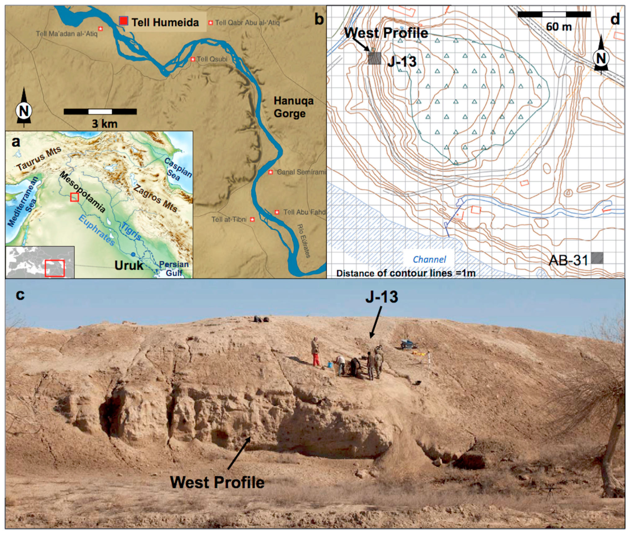
Tell Humeida is located on the left bank of the Euphrates River, 75 km north of the Syrian city of Deir ez-Zor (Figure 1). The research at the site was part of the Middle Syrian Euphrates Archaeological Project (PAMES, acronym in Spanish), a scientific initiative coordinated and launched by the University of A Coruña and the General Directorate of Antiquities and Museums in Damascus in 2005. The geographical setting of this project was the basalt gorge of Hanuqa (Figure 1b) in the Syrian province of Deir ez-Zor [1]. The fieldwork consisted of four archaeological survey campaigns in the region around the gorge (2005–2009), as well as three excavation campaigns at Tell Qabr Abu al-’Atiq (2008–2010) and one at Tell Humeida (2011).
The work carried out showed the historical importance of the Hanuqa Gorge in both pre-classical and classical times [2]. This fact was directly related to the strategic value of this geographical feature, which marked a turning point in the Middle Euphrates basin in Syria. In the fourth millennium BC, people from southern Mesopotamia settled at Tell Humeida, the entrance to Hanuqa. Their presence must be explained in the context of the complex expansion process of the so-called Uruk culture [3]. The actual reasons that led to this phenomenon remain a controversial question, for which various explanations have been proposed [4]. As a hypothesis, Ref. [5] proposed that the Uruk settlements documented in the Middle Euphrates Valley in Syria can be classified into three different habitat types based on their material culture, namely, colonies founded ex novo by people coming from the south (intrusion culture), trade enclaves founded in pre-existing indigenous settlements (hybrid culture), and trade sites frequented by Uruk merchants (with local cultural dominance).

Figure 1. (a) General location map. The inset marks the detailed area in (b), the Hanuqa Gorge and Tell Humeida on the Middle Euphrates. (c) General view of the site from the west. (d) Detailed topographical map of Tell Humeida showing the excavation sites. Contour lines: 1 m.
Tell Humeida was most likely a colony of Uruk whose main purpose was to control the main waterway (the Euphrates and its tributary Habur), which provided access to raw materials that were in short supply in Lower Mesopotamia. Research at this archaeological site sheds new light on various aspects of material culture and lifestyle in the so-called Middle and Late Uruk Period, also known as Late Chalcolithic 4-5 (c. 3600–3000 BC). Noteworthy, for example, are new contributions on the production and function of beveled rim bowls (BRB), a little-known type of ceramic vessel that is nevertheless considered an identity marker of the entire culture [6][7][8][9][10].
Fieldwork at Tell Humeida has been interrupted since March 2011 due to the outbreak of the political conflict in Syria. Due to this suspension, people only had scarce study materials, including a series of skeletal remains of animals, most of which were difficult to identify due to their fragmented state. However, the application of analytical techniques such as taxonomic identification by means of peptide fingerprinting and stable isotope analysis allowed us to overcome this problem. The research present the results of these analyses, together with the study of carpological remains and the dating of charcoals and sediments, in order to obtain as much information as possible as the inaccessibility of the site prevents progress in its investigation.
2. The Site and the Archaeological Surveys
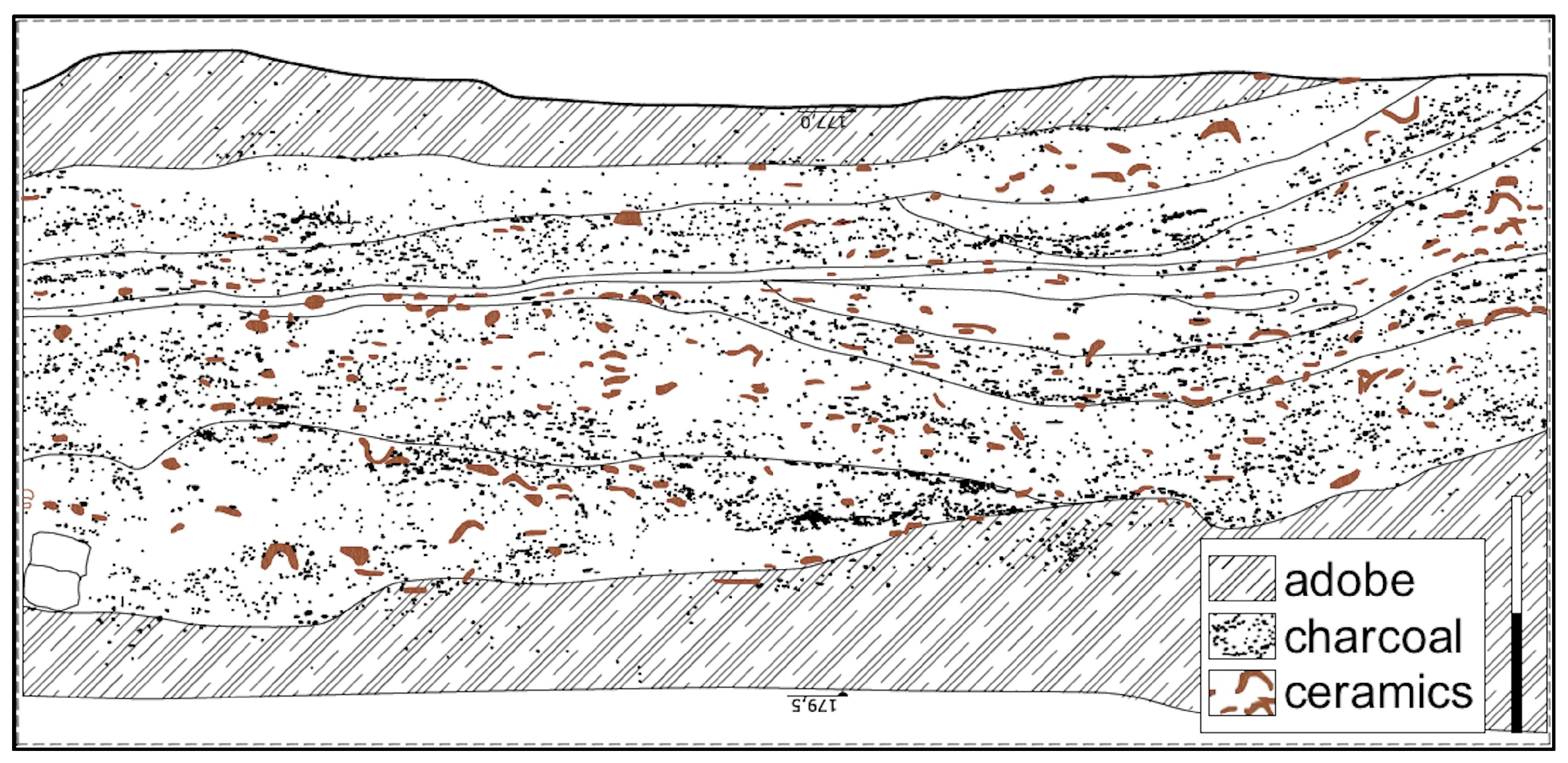
The archaeological site of Tell Humeida, which occupies an area of 6 ha, consists of two sectors (Figure 1d): a roughly circular mound (150 m in diameter) and a lower area extending 260 m to the east. The western part of the mound suffered from considerable erosion, probably caused by the nearby waters of the Euphrates. Consequently, a large stratigraphic section 3 m high and 17 m long emerged, which people call the West Profile (WP). In this profile, the abundance of ceramics, including the beveled rim bowls characteristic of the Middle–Late Uruk period, was visible to the naked eye. Bone remains and charcoal were also present. The arrangement and type of material suggested that this was a midden area (Figure 2).

Figure 2. Section of the west profile (WP).
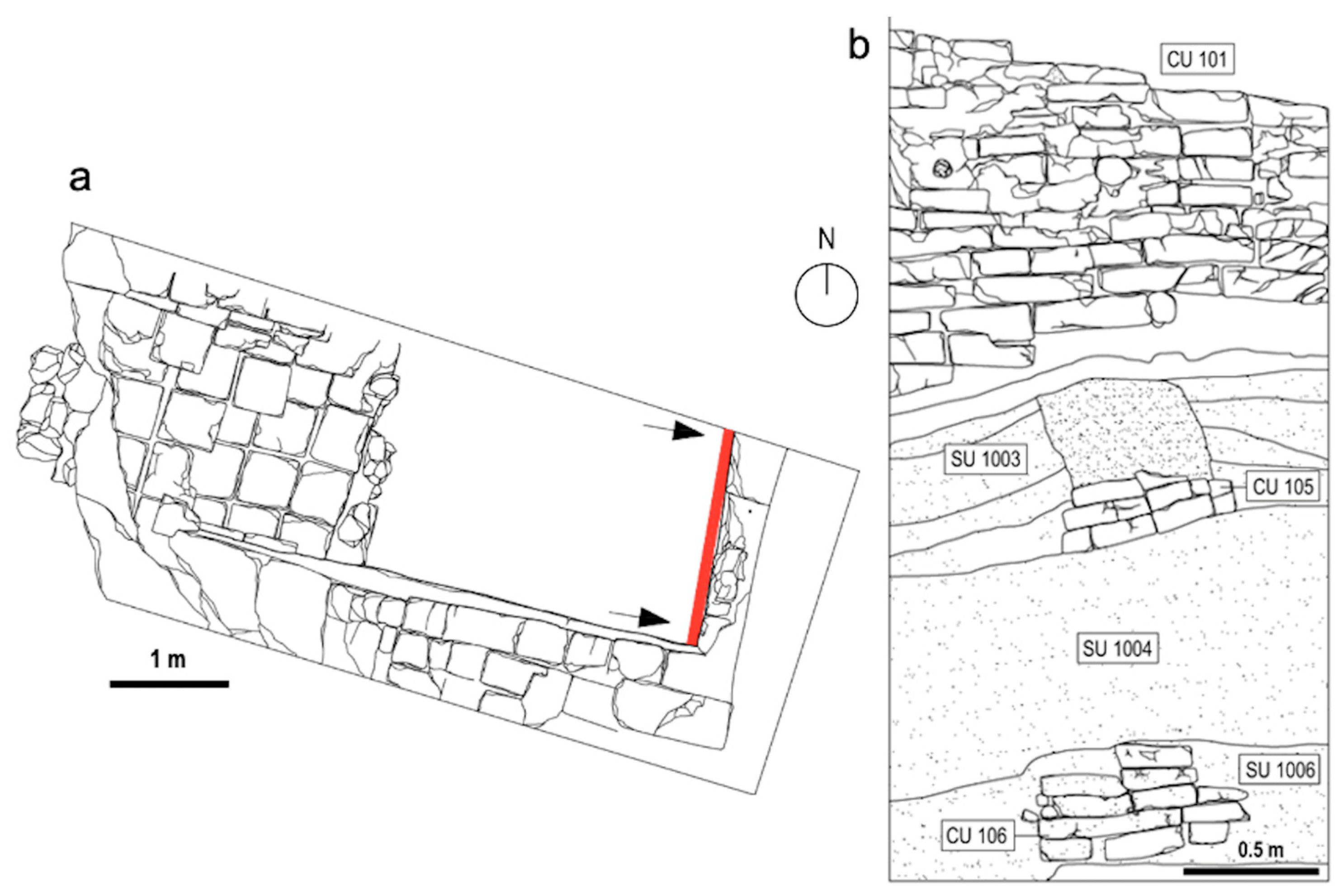
During the 2011 campaign, two archaeological surveys were carried out at Tell Humeida: a test sounding of 5 × 5 m in the square J-13, on the mound, just above WP (Figure 3), and AB-31, in the lower area. In J-13, two periods of occupation were excavated: Palaeobyzantine (sixth to seventh cal AD) and Middle Uruk, with three phases of occupation [11]. The most recent phase consisted of Stratigraphic Unit 1003 (SU 1003), which holds a wall or Constructive Unit 105 (CU 105), preserving three courses of mud bricks of modest size (22 × 11 × 9 cm), a type of Uruk-period brick known as riemchen. The second phase was SU 1004, together with SU 1005 and SU 1006, in which charcoal, ashes, animal bones, and pottery abounded, especially the characteristic beveled rim bowls. This midden-like level apparently corresponded to that revealed in WP. Finally, the remains of an adobe wall documented beneath this debris fill composed the third phase (CU 106). The second survey in the lower area (see Figure 1d), AB-31 (10 × 10 m), yielded no evidence from the Uruk period.

Figure 3. (a) Plan and (b) section of the west profile (WP) showing the main stratigraphic units (SU) and constructive units (CU). In this profile, SU 1005 is not visible but consists of the same materials of SU 1004 disturbed at the contact with the Byzantine wall.
3. Stable Isotopes Rationale
A good option for studying past economies when the bone record is poor, as in this case, is to resort to stable isotope analysis. Stable carbon (δ13C) and nitrogen (δ15N) isotope ratios of bone collagen have become a routine method for the study of human and animal nutrition [12][13]. In addition, the C and N isotope signatures of plant remains (grains, seeds, chaff, etc.) reflect environmental conditions at the time, such as human-mediated or non-mediated water availability or manure fertilization [14]. Thus, the combination of the isotopic data of animals and plants from a site provides important data on the economy of ancient societies, their farming methods, and the husbandry of their animals [15]. The study of trophic relationships between organisms using stable isotopes is possible due to isotopic fractionation, the phenomenon whereby the isotopic composition of an element in a given compound changes as it transitions from one physical state or chemical composition to another [16][17]. An example is the change in isotope ratio values (δ13C, δ15N) that occurs between an organism and its diet, often referred to as the trophic offset. This is due to the preferential mobilization of the light isotope and retention of the heavy isotope during food assimilation and tissue synthesis, in this case, of bone collagen [18].
The relative composition of carbon stable isotopes in plants is determined by the values in atmospheric CO2, which changed considerably from pre-industrial times to the present day due to the burning of fossil fuels. While the value of atmospheric CO2 today is about −8‰, values between −6‰ and −6.5‰ were recorded in the Chalcolithic [19]. The isotope values in the plant depend directly on the type of photosynthesis carried out, which can be of the C3, C4, or CAM type [20][21]. C3 plants are herbaceous and shrubby plants of temperate or cold climates, including most cereals. When taking up CO2, C3 plants discriminate strongly against 13CO2 and prefer to take up molecules with 12C. Therefore, the δ13C values of the plant are lower than those of the air (between −12.4‰ and −37.0‰ [16]). During water stress, C3 plants close the stomata to prevent water loss through evapotranspiration. This leads to a lower discrimination ability of the plants toward CO2 molecules with the heavy isotope and thus to an increase in the δ13C signature. Thus, variations in plant δ13C relative to atmospheric CO2 levels values (∆13C) reflect greater or lesser availability of water depending on climate and plant irrigation [19][22][23][24]. In contrast, C4 plants (warm-climate herbaceous plants, including various crops such as millet, sorghum, sugarcane, maize, etc.) are better adapted to dry climates. Because they decouple photosynthesis from CO2 uptake, C4 plants have systematically higher δ13C values (between −2.0‰ and −14.0‰ [16]). The CAM plants, Crassulaceae, show an intermediate metabolism and intermediate δ13C values. The bone collagen of primary consumers is enriched by +5‰ over the plants they feed on [25]. From herbivores and up the food chain, the trophic offset between prey and predator is lower, varying from +0.8‰ to +1.3‰, according to [26].
Several factors have a significant influence on nitrogen isotopic values in plants. Soil nitrogen synthesis is crucial because microbial activity depends on climate, i.e., on the chronology and geographical location, specifically latitude and altitude [27][28]. Plants of the family Fabaceae take up N directly from the air through symbiotic bacteria and usually have lower δ15N values than the rest of the vegetation [29]. In plants from agricultural systems, fertilization of crops with manure or slash and burn agriculture produces an increase in δ15N in the crop by as much as 2 to 5‰ [14][30]. The relative composition of nitrogen isotopes in bone collagen is related to the position of the individual in the food web as each trophic level is characterized by an average increase in the value between 3 and 5‰ [26]. In addition to the diet type, individual nitrogen metabolism also influences the isotopic signature recorded in mammalian bone collagen. In mammals living in arid areas, high δ15N values have been reported, which have been attributed to the mammals’ own physiology under water stress conditions [31][32] or to their preference for certain types of plants [33].
This entry is adapted from the peer-reviewed paper 10.3390/d15060709
References
- Montero Fenollós, J.L. Le défilé de Khanuqa. Géographie e histoire au Moyen Euphrate méridional. Isimu 2011, 13, 125–136. Available online: http://hdl.handle.net/10486/667759 (accessed on 9 December 2019).
- Fenollós, J.L.M.; Caramelo, F.; Masó, F. De Uruk a Bizancio. Investigaciones del Proyecto Arqueológico Medio Éufrates Sirio (2005–2011); Sociedade Luso-Galega de Estudos Mesopotámicos: Ferrol, Spain, 2012.
- Algaze, A. The Uruk World System: The Dynamics of Expansion of Early Mesopotamia; University of Chicago Press: Chicago, IL, USA, 2005.
- Butterlin, P. Architecture et Société au Proche-Orient Ancient; Picard: Paris, France, 2018; pp. 407–427.
- Montero Fenollós, J.L. De Uruk a Mari. Innovaciones tecnológicas de la Primera Revolución Urbana en el Medio Éufrates meridional. Anejos Nailos Estud. Interdiscip. Arqueol. 2014, 1, 139–155. Available online: https://nailos.org/index.php/nailos/article/view/81 (accessed on 9 December 2019).
- Sanjurjo Sánchez, J.; Montero Fenollós, J.L.; Prudêncio, M.I.; Barrientos, V.; Marques, R.; Dias, M.I. Geochemical study of beveled rim bowls from the Middle Syrian Euphrates sites. J. Archaeol. Sci. Rep. 2016, 7, 808–881.
- Sanjurjo Sánchez, J.; Montero Fenollós, J.L.; Barrientos, V.; Polymeris, G.S. Assessing the firing temperature of Uruk pottery in the Middle Euphrates Valley (Syria): Bevelled rim bowls. Microchem. J. 2018, 142, 43–53.
- Sanjurjo Sánchez, J.; Montero Fenollós, J.L.; Polymeris, G.S. Technological aspects of Mesopotamiam Uruk pottery: Esti-mating firing temperatures using mineralogical methods, thermal analysis and luminescence techniques. Archaeol. Anthropol. Sci. 2018, 10, 849–864.
- Sanjurjo Sánchez, J.; Kaal, J.; Montero Fenollós, J.L. Organic matter from bevelled rim bowls of the Middle Euphrates: Results from molecular characterization using pyrolysis-GC–MS. Microchem. J. 2018, 141, 1–6.
- Montero Fenollós, J.L.; Sanjurjo-Sánchez, J. El proceso de fabricación de los cuencos con borde biselado mesopotámicos. Nuevas aportaciones desde la arqueología experimental. Spal 2021, 30.2, 103–123.
- Montero Fenollós, J.L.; Caramelo, F.; Márquez Rowe, I.; al-Abdalleh, Y. Excavaciones arqueológicas en Tall Humeida (Siria). In Informes y Trabajos 7. Excavaciones en el Exterior 2010; Ministerio de Educación, Cultura y Deporte de España: Madrid, Spain, 2012; pp. 309–315. Available online: https://www.libreria.culturaydeporte.gob.es/ebook/3746/free_download/ (accessed on 9 December 2019).
- Schwarcz, H.P.; Schoeninger, M.J. Stable isotope analyses in human nutritional ecology. Am. J. Phys. Anthr. 1991, 34, 283–321.
- Hedges, R.E.M.; Reynard, L.M. Nitrogen isotopes and the trophic level of humans in archaeology. J. Archaeol. Sci. 2007, 34, 1240–1251.
- Bogaard, A.; Heaton, T.H.E.; Poulton, P.; Merbach, I. The impact of manuring on nitrogen isotope ratios in cereals: Archaeological implications for reconstruction of diet and crop management practices. J. Archaeol. Sci. 2007, 34, 335–343.
- Szpak, P. Complexities of nitrogen isotope biogeochemistry in plant-soil systems: Implications for the study of ancient agricultural and animal management practices. Front. Plant Sci. 2014, 5, 288.
- Michener, R.; Lajtha, K. Stable Isotopes in Ecology and Environmental Science, 2nd ed.; Wiley: Hoboken, NJ, USA, 2008.
- Faure, G.; Mensing, T. Isotopes: Principles and Applications, 3rd ed.; Wiley: Delhi, India, 2004; p. 928.
- Koch, P.L.; Fogel, M.L.; Tuross, N. Tracing the diets of fossil animals using stable isotopes. In Stable Isotopes in Ecology and Environmental Science; Lajtha, K., Michener, R.H., Eds.; Blackwell Scientific Publications: Boston, MA, USA, 1994; pp. 63–92.
- Wallace, M.; Jones, G.; Charles, M.; Fraser, R.; Halstead, P.; Heaton, T.H.E.; Bogaard, A. Stable carbon isotope analysis as a direct means of inferring crop water status and water management practices. World Archaeol. 2013, 45, 388–409.
- Van der Merwe, N.J. Carbon Isotopes, Photosynthesis, and Archaeology. Am. Sci. 1982, 70, 596–606. Available online: http://www.jstor.org/stable/27851731 (accessed on 17 December 2022).
- Farquhar, G.D.; Ehleringer, J.R.; Hubick, K.T. Carbon Isotope Discrimination and Photosynthesis. Annu. Rev. Plant Physiol. Plant Mol. Biol. 1989, 40, 503–537.
- O’Leary, M.H. Carbon isotope fractionation in plants. Phytochemistry 1981, 20, 553–567.
- Araus, J.L.; Febrero, A.; Catala, M.; Molist, M.; Voltas, J.; Romagosa, I. Crop water availability in early agriculture: Evidence from carbon isotope discrimination of seeds from a tenth millennium BP site on the Euphrates. Glob. Change Biol. 1999, 5, 201–212.
- Araus, J.L.; Ferrio, J.P.; Voltas, J.; Aguilera, M.; Buxó, R. Agronomic conditions and crop evolution in ancient Near East agriculture. Nat. Commun. 2014, 5, 3953.
- Ambrose, S.H.; Norr, L. Experimental Evidence for the Relationship of the Carbon Isotope Ratios of Whole Diet and Dietary Protein to Those of Bone Collagen and Carbonate. In Prehistoric Human Bone; Lambert, J.B., Grupe, G., Eds.; Springer: Heidelberg, Germany, 1993.
- Bocherens, H.; Drucker, D. Trophic level isotopic enrichment of carbon and nitrogen in bone collagen: Case studies from recent and ancient terrestrial ecosystems. Int. J. Osteoarchaeol. 2003, 13, 46–53.
- Amundson, R.; Austin, A.T.; Schuur, E.A.G.; Yoo, K.; Matzek, V.; Kendall, C.; Uebersax, A.; Brenner, D.; Baisden, W.T. Global patterns of the isotopic composition of soil and plant nitrogen. Glob. Biogeochem. Cycles 2003, 17, 1031.
- Männel, T.T.; Auerswald, K.; Schnyder, H. Altitudinal gradients of grassland carbon and nitrogen isotope composition are recorded in the hair of grazers. Glob. Ecol. Biogeogr. 2007, 16, 583–592.
- Dawson, T.E.; Mambelli, S.; Plamboeck, A.H.; Templer, P.H.; Tu, K.P. Stable Isotopes in Plant Ecology. Annu. Rev. Ecol. Syst. 2002, 33, 507–559.
- Fraser, R.A.; Bogaard, A.; Heaton, T.; Charles, M.; Jones, G.; Christensen, B.T.; Halstead, P.; Merbach, I.; Poulton, P.R.; Sparkes, D.; et al. Manuring and stable nitrogen isotope ratios in cereals and pulses: Towards a new archaeobotanical approach to the inference of land use and dietary practices. J. Archaeol. Sci. 2011, 38, 2790–2804.
- Heaton, T.H.E.; Vogel, J.C.; Von La Chevallerie, G.; Collett, G. Climatic influence on the isotopic composition of bone nitrogen. Nature 1986, 322, 822–823.
- Cormie, A.; Schwarcz, H. Effects of climate on deer bone δ15N and δ13C: Lack of precipitation effects on δ15N for animals consuming low amounts of C4 plants. Geochim. Cosmochim. Acta 1996, 60, 4161–4166.
- Hartman, G. Are elevated δ15N values in herbivores in hot and arid environments caused by diet or animal physiology? Funct. Ecol. 2010, 25, 122–131.
This entry is offline, you can click here to edit this entry!
