Your browser does not fully support modern features. Please upgrade for a smoother experience.
Please note this is an old version of this entry, which may differ significantly from the current revision.
Subjects:
Geochemistry & Geophysics
Certain areas of the Kingdom of Saudi Arabia (KSA) are assessed in order to map potential geothermal energy zones. To evaluate high-resolution aerial magnetic data, spectral depth analysis using a modified centroid approach was used. The calculated geothermal parameters were gridded in order to delineate the regions characterised by a shallow Curie point depth (CPD) and a high geothermal gradient (GG) as well as a high heat flow (HF).
- Curie point depth
- heat flow
- centroid depth
- geothermal gradient
1. Introduction
The Red Sea geodynamic processes control the tectonics and geology of the Kingdom of Saudi Arabia (KSA) and have caused the formation of a new oceanic crust along the axial trough, which is strongly supported by geophysical and geological results [1]. The Kingdom of Saudi Arabia is thought to be rich in geothermal energy resources, particularly the Neoproterozoic Arabian Shield, which is characterized by vast thermal springs, lava fields and volcanic and tectonic activities [2].
Early assessments of the geothermal potential in the KSA, conducted with geothermometers and geochemical, geological and geophysical approaches, found a wide range of reservoir temperatures (130–220 °C) and heat flows (120–210 W/m2) linked with hot springs [3]. These hot springs and minerals exist in the neighbourhood of the magmatic intrusions of the Precambrian to the Recent age [4]. Previous geophysical studies have shown that the major Northwest–Southeast-, Northeast–Southwest- and East–West-directed fault zones control the geothermal systems and the deposition of gold, base metals and other precious metals [4,5,6,7]. Several geoscience investigations in the KSA focused on hydrocarbon and mineral explorations [8]. However, a few geothermal investigations have been conducted in the KSA [3,9,10]. These recent geothermal investigations are expected to help the KSA to become completely powered by renewable and low-carbon energies, hence freeing up more hydrocarbon for export to boost the economy [9]. Nevertheless, the KSA has a high electricity production of about 240 terawatts with about 192 terawatts and 17 million kWh applied for cooling purposes and desalination processes, respectively [3]. These activities and others have increased the CO2 released from fuel combustion in the KSA from 252,000 Gg (in the year 2000) to about 446,000 Gg, presently [3].
Several recent geoscience studies all over the world are centred on reconnaissance explorations for geothermal resources [11,12,13] using magnetic data. Seismic, magnetotelluric, electrical resistivity, transient electromagnetic and bottom-hole temperature techniques, on the other hand, can be used in geothermal research and monitoring [14]. Overall, the magnetic method is an effective exploratory tool for determining the presence, lateral extent and depth of natural resources in the subsurface [15,16,17,18,19]. Likewise, magnetic data have been successfully applied in mapping the subsurface bedrock topography [2] and sediment thicknesses [20,21,22], in the early phases of geothermal developments. The magnetic data have significantly reduced the quantity of drilled wells needed to evaluate feasible geothermal fields. This method is the least expensive geophysical procedure for delineating the geothermal system of a region [23]. The aero-magnetic method is an operative tool in defining the regional surficial geologic borders [19] as well as the basement framework [24]. Likewise, it can be used for isolating anomalous geologic structures and bodies triggered by magnetic disparities [25]. In addition, magnetic data can be applied for mineral assessment programs, delineating hydrothermally altered rocks and geologic structures [26]. Additionally, it can be used in petroleum explorations, archaeological investigations and detection of unexploded ordnance [27,28]. Furthermore, lineaments and rift minerals interconnected with igneous intrusions can be explored by applying magnetic data [2,16]. This technique has been valuable in delineating geothermal reservoirs, basement framework, igneous intrusions [20] and magma chambers interconnected with the geothermal system source of heat [29]. Additionally, the magnetic method can be used to locate regions with diminished magnetization caused by thermal events, hydrothermal system assessment [30], concealed anomalies originated by granitic as well as magmatic structures [16] and associated lineaments [31,32,33]. Over the years, the various procedures involved in magnetic data acquisition, corrections, enhancements, presentations and interpretations have been considerably upgraded [19]. On the other hand, this method is normally connected with ill-posed inverse problems and characterized by unstable and non-unique solutions [19,20,34,35]. Nevertheless, reliable solutions to magnetic results can be acquired by applying enhanced procedures combined with a proper knowledge of geology [19].
In this investigation, Magsat satellite-generated magnetic data flown by NASA were used to offer insights into the subsurface geothermal anomalies [36]. The data that have the potential to probe different rock properties were applied to locate and determine the trend of geothermal systems and structures within the KSA. The world is composed of continents with various crustal blocks. These crustal blocks have different compositions, tectonic histories, ages and wide range of magnetic susceptibilities caused mostly by igneous intrusions [37]. Magnetic properties associated with various crustal blocks can be measured at satellite altitudes [38,39]. Previous studies have shown that igneous intrusion and extrusion have distinct magnetic content [19]. The satellite magnetic data can be used to detect anomalies over oceanic rises, plateaux and subduction regions that are in general inferred for induced magnetization effects [40]. These magnetic anomalies ordinarily and absolutely match to bathymetric structures with anomaly peaks over rises and plateaux, and trough over the basins [41]. Magnetic anomaly maps using a regional to continental scale are becoming readily accessible from terrestrial, shipborne and airborne surveys [42]. Satellite-generated magnetic data are generally well-thought-out to seal the coverage lacunas in the regional assembling of these near-surface surveys. All in all, crustal magnetic anomaly maps at satellite heights can be analysed simply for regional geologic structures [42]. Nevertheless, for analyses and deductions involving smaller-scale magnetic structures, satellite height anomalies are normally enhanced downwards [42]. On the other hand, aeromagnetic techniques flown from aircrafts or drones are routinely conducted around the world for various applications, as the magnetometer is, today, a standard instrument on any airborne geophysical survey. For example, many continents, such as North America, are entirely covered with aeromagnetic surveys with lines spaced from 0.1 to 1 km.
2. Geothermal Anomalies in the Neoproterozoic Arabian Shield
The studied geological region is a section of the Arabian Shield (AS) in Saudi Arabia. It is geographically situated between latitudes 16.0°–30.0° N and longitudes 35.0°–48.0° E (Figure 1). The study location is bordered by Jordan, Iraq and Kuwait, Iran and Arabian Gulf, Rub’Al Khali Desert, Oman, Yemen, Egypt and Red Sea, and Eritrea to the northwest, north, northeast, east, southeast, south, west and southwest, respectively. The Kingdom of Saudi Arabia is characterized by two geological provinces: the Arabian Shield in the west and the Arabian Shelf in the east. The Arabian Shield (SA) is dominated by Precambrian (igneous and metamorphic) rocks classified into the Asir, Jeddah, Afif, Ad Dawadimi, Ar Rayn, Ha’il, Hijaz and Midyan terranes on the basis of their formation modes [43]. There are pockets of Archean and Paleoproterozoic lithologies inside the prevalent Neoproterozoic lithologies, which arose over 300 million years of the tectonic crustal expansion that commenced 850 Ma ago [44]. A sequence of magmatic arcs, sedimentary and volcanic basins, and granitic intrusions were produced by at least three continental collisions over the course of 300 million years. The opening of the Mozambique Ocean was triggered by the breakup and separation of Rodinia between 900 and 800 Ma ago, and intra-oceanic subduction is frequent [45].
The island arcs above them were accreted to the AS by the convergence of cratonic blocks during Cryogenian–Ediacaran, and the accretion zone is exposed on the surface as suture zones. With the formation of Gondwana, the accretions began in the southern AS, progressed north and finally concluded in the northeast AS. In the eastern AS, where the halt of accretion is poorly understood, no pre-EAO blocks are recorded. The Arabian Shelf is a succession of Paleozoic and newer sediments that were predominantly deposited along passive borders and contain up to 10 km of limestones and siliciclastics [44,45].
The Paleozoic series contains the world-famous oil and gas fields [46]. With the collision of east and west Gondwana, the NW-trending Najd fault system, crustal-scale sinistral strike-slip faults and ductile shear zones formed and had an effect on the AS [47]. This Najd fault system (NFS), which is approximately 2000 km long, 400 km wide and partially covered by Cenozoic lavas and alluvium [48], is comprised of a network of parallel and en echelon faults as well as secondary structures, such as strike-slip, oblique-slip, thrust and normal faults as well as folds and dike swarms. As a result of movement along the Najd fault system, the Dokhan volcanic, granite plutonism and molasse basins have been revealed and developed [47]. In some instances, the Najd fault system reactivates older Neo-Proterozoic terranes by traversing them. The NFS has predominantly brittle deformation, while the south-eastern AS contains a tectonic fabric that penetrates the fault zone. In addition, strike-slip faults with a north–south orientation in the southern AS (Asir Terrane) and eastern AS [44] are part of crustal-scale fault systems. Within the Jeddah Terrane, strike-slip faults have a northeast–southwest orientation [48]. These prominent geological structures serve as weak zones for igneous intrusions as well as pathways for hot springs and harrats. The geophysical information and wells drilled in the Rub’ Al Khali indicate the existence of a basin beneath the Quaternary sand [49].
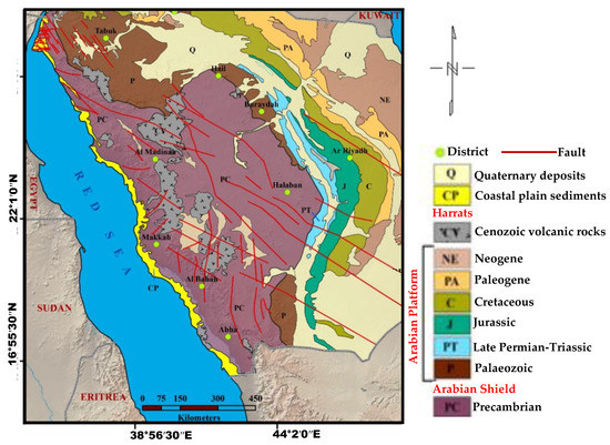
Figure 1. Geological setting of the study location.
This entry is adapted from the peer-reviewed paper 10.3390/min13050694
This entry is offline, you can click here to edit this entry!