Coherence of Bangui Magnetic Anomaly: Comparison
Please note this is a comparison between Version 1 by Polina Lemenkova and Version 2 by Camila Xu.

The interactions between the geophysical processes and geodynamics of the lithosphere play a crucial role in the geologic structure of the Earth’s crust. The Bangui magnetic anomaly is a notable feature in the lithospheric structure of the Central African Republic (CAR) resulting from a complex tectonic evolution.

  • programming
  • geophysics
  • GMT
  • mapping
  • Africa
  • geology

1. Introduction

1.1. Background

The problem of feature matching in Earth studies can be described as matching the extent, direction and intensity of the geophysical and geologic processes, objects and phenomena visualised on the maps. A particular geophysical orgeologic feature is associated with a coordinate position in a cartographic domain identifying its location, and variables representing its appearance either by the points for discrete objects or by the fields for continuum processes. For analysis of correlation and links between diverse geologic and geophysical variables, matched feature points and continued fields represented on the maps should maintain similar regional appearance as well as relative spatial relationships with other processes, e.g., variation in topography or geoid and regional distribution of the geologic units. Analysis of correlation between geophysical and geological variables has extensive uses in integrated geophysical and seismic analysis [1], hydrological and engineering geological studies [2][3][4][2,3,4], geophysical anomalies [5], mineral exploration [6], or landslide hazard risk assessment in the areas with complex geology [7][8][7,8].
Each cartographic-matching method supports either a specific data format, e.g., such as ArcGIS shape files [9][10][11][9,10,11] or the tiled format for image processing in remote sensing software [12][13][12,13] or a limited set of converted and imported data formats from the multi-source data [14][15][16][14,15,16]. Scripting and programming methods also showed their effectiveness in matching tasks and coherence analysis when dealing with topographic and geophysical datasets since they optimise the workflow via smooth, automated and rapid approaches in data processing. For instance, scripts facilitate the modelling of geochemical–geophysical inversion to investigate the issues of dynamic topography [17], enable automated and optimised isolines approximation and mesh gradation in topographic data processing [18], or support detailed topographic analysis through 3D cross-sections [19][20][19,20].

2. Regional Geology

The geology of CAR is notable by the presence of the two prominent greenstone belts formed during the Archaean Eon as metamorphosed mafic volcanic sequences within the granite–gneiss volumes [21][37]. The greenstone belts are located to the north of Bouca in the West Zaire Precambrian Belt (Figure 12) as narrow subparallel bands of the extrusive igneous rocks (basalts and andesites) placed on a sialitic basement [22][38]. The first one is a 250-km long Bandas belt composed of volcanic and metasedimentary rocks [23][39] and the second is located in the west—a 150-km long Bogoin-Boali belt with anomalously high gold deposits [24][40]. They further include the tholeiitic basalts, dolerites from the Proterozoic dyke swarms and sills and andesites formed during crystallization of the basaltic magma [25][41].
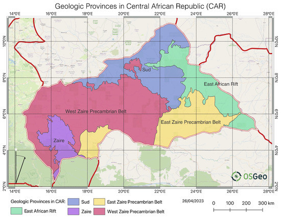
Figure 12.
Geologic provinces in CAR. Data source: USGS. Background topographic map: OSGeo.
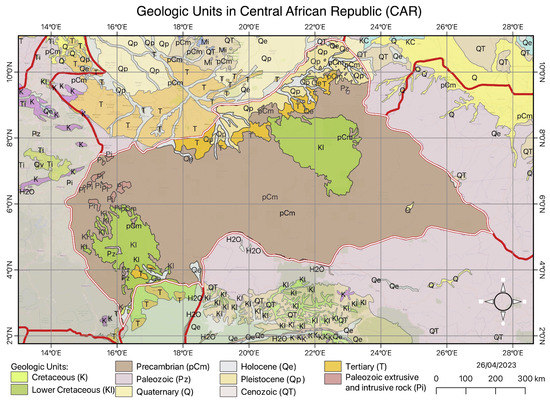
The geochemistry of the greenstone belts also includes the metamorphic minerals of the greenschist facies, pyroxenes and olivines [26][42]. The presence of back-arc tholeiites and arc-related greywackes argues for a compressive margin plate boundary for the greenstone belts indicating high tectonic activity in the marginal areas of the Congolese Craton [27][43]. Further, the arc-related ultramafic origin of the bulk rocks caused by complex tectonic activity in the past, is also proved by [28][44] who reported on the geochemistry and petrogenesis of ultramafic rocks in the Precambrian terrane of the northern CAR. They indicate that the presence of olivine and pyroxene, magnesio-hornblende and magnetite in the West Zaire Precambrian Belt (Figure 12) indicates intense Precambrian mafic magmatism processes in the past. The magnesian intrusive of Paleoproterozoic age is also found in the Tamkoro-Bossangoa Massif in the northwest intruded into a strike-slip shear zone. They are composed by gneisses with grained quartz diorites and biotite granites [29][45]. The deposits of the Bangui basin in the southern region of the CAR are dominated by the granodiorites which belong to the foreland of the Pan-African Oubanguides belt in the stratum deposited during the Proterozoic period of the Precambrian (pCm) [30][46]. The metamorphic rocks of the Bossangoa-Bossembélé area in the north of the country consist of the sedimentary and igneous units which are indicative of granulite facies conditions deposited on an old Paleoproterozoic continental crust [31][32][47,48]. The Precambrian carbonate platforms are widely distributed in CAR as the remaining evidence of the paleoenvironment. For instance, these include the carbonate deposits in the Ombella-M’poko Formation consisting of metamorphosed carbonate facies (calcite, dolomite and quartz) on top of the fluvioglacial sediments covered by siliciclastics [33][49]. Later examples of the palaeogeographic formations include the Carnot—a Mesozoic fluvio-lacustrine detrital formation located in the western part of the CAR and presented by clastic material formed before the end of the Cretaceous [34][50]. More details on alluvial deposits of Carnot sandstones are given in [35][51]. Active tectonic movements and volcanic eruptions during the Cretaceous resulted in distribution of the typical morphological bodies of the intrusives igneous rocks—dykes and sills [36][52]. Regional stratigraphy of the CAR is illustrated in Figure 23. The stratigraphic succession is presented by the oldest rocks from the Precambrian (Pc) and following Paleozoic (Pz) periods; the Mesozoic successions comprised of rocks from the Cretaceous (K) and Lower Cretaceous (Kl) periods; Cenozoic (QT) successions comprised of rocks from the Pleistocene (Qp), Holocene (Qe), Quaternary (Q) and Tertiary (T) periods. The Precambrian (pCm) metamorphic formation is most exposed with dominating quartzite-schistose and upper quartzite (Bangui and Nola) series. The granitic bodies and associated gneisses of Lower Proterozoic age of Precambrian period intruding the upper series were tectonized during the period of orogeny and form the basement in the south-central CAR [37][53]. The greenstone belt of pCm, covered by a series of conglomerates, is distributed on a granitized gneiss basement and includes volcanites and schists [38][54].
Figure 23.
Geologic units and lithology in CAR. Data: USGS.
The southern region of CAR lithology continues along the northern border of the Congo Craton and is presented by the Lower Cretaceous (Kl) and Precambrian (pCm) successions (Figure 23). It is mostly composed of tholeitic basalts and gabbros of mafic and ultramafic rocks corresponding to the oceanic basalts and gabbros associated with iron-rich sediments and gneisses [39][55]. The Lower Cretaceous (Kl) succession, the second widely distributed in CAR, includes the fluvio-lacustrine deposits on the Central African shield [22][38]. Further, the interfluves of the dense fluvial network of rivers in CAR correspond to the series of plateaus with the presence of the polymorphic sandstones Tertiary (T) with the valleys composed of soft sandstone and argillites of Cretaceous (K) [40][56]. Further, the Bangui region is characterised by the Plutonic massifs distributed in the Ngouaka-Gbago area which include the gabbro, granodiorite, and granites that experienced the processes of the greenschist facies metamorphism [41][57]. The Paleozoic (Pz) period is notable for the emergence and geomorphic erosion in the earlier reliefs which resulted in the upper hilly surface of argillites in the northern regions of CAR [42][58]. The alluvium and colluvium from the Pleistocene (Qp) valleys with modern sediments of Holocene (Qe) form the basin of the modern Aouk river and its tributaries which create a natural border between CAR and Chad, Figure 23. The formations in the alluvial deposits also include notable intrusions of diamonds formed as a result of the ascent of the upper mantle and related magmatic processes during the geological history of CAR [43][44][45][46][59,60,61,62]. The geological development with favourable environmental setting of CAR situated in the equatorial, humid tropical and subequatorial climate resulted in its diverse natural resources. Rich mineral resources include gold-mining fields in the quartz veins in greenschist facies of the Paleoproterozoic formations [47][63] and alluvial diamonds [48][64]. The latter ones are distributed in the south-western and north-eastern regions in the Carnot and Mouka-Ouadda Sandstone formations [45][49][61,65]. The geomorphology of most of the CAR is represented by flat or hilly plateaus with dominated savannah [50][66] and dense ombrophile forest in the southern regions of the country [51][67] and the extreme northeast regions of CAR are a steppe. The northern region near the Bamingui and Bangoran rivers is presented by the Sahel-tropical forest [52][68]. The distribution of crops and related agriculture activities correspond to the different types of soil within various regions of the country which is in turn largely controlled by the regional setting of the geologic basement [53][54][55][69,70,71]. For instance, the organic matter in soil is controlled by the underlying geology as determining its chemical and physical nature. As a result, the extent and types of habitats and vegetation patterns vary accordingly [56][57][72,73]. Further, carbonated bed formations favour the development of karsts with typical relief and limestone soils in the southern regions of the Oubangui Basin [58][74].
Video Production Service