1. Rearch Areas of DAUE
1. The Booming of DAUE Study and Transition of Involved Research Institutions
The key research areas of current DAUE include (1) exploring the qualitative/quantitative relationship between urban expansion and certain driving factors; (2) identifying the major driving factors of urban expansion from socio-economic, policy, topographic, and other perspectives; (3) understanding the spatiotemporal dynamics of driving effects or mechanisms during the process of long-term urban expansion; and (4) providing theoretical support for urban expansion modelling.
1.1. Three Identified Development Stages of DAUE
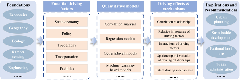
Figure 1. Road map for DAUE study.
2. The Booming of DAUE Study and Transition of Involved Research Institutions
2.1. Three Identified Development Stages of DAUE
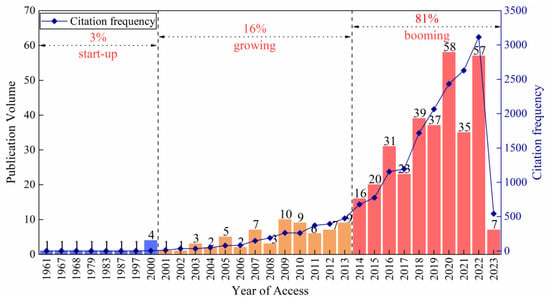
As Figure 2 illustrates, from January 1961 to March 2023, the annual publication volume (including early accessed paper) and total citation frequency of DAUE studies undergo an overall exponential increase. Three development stages of DAUE can be identified: the start-up stage (1961–2000), growing stage (2001–2013) and booming stage (2014–2023). The publication volume in these three stages accounts for 3%, 16%, and 81%, respectively of the total publications. In the start-up stage, only one DAUE paper was published per year; during the growing stage, the number of publications increased slowly and unsteadily, with the count of annual publications at no more than ten, and the citation frequency generally below 500. Comparatively, during the booming stage, the annual publication volume and total citation frequency underwent an obviously explosive growth, indicating that DAUE attracted extensive attention and experienced rapid development during this stage.
Figure 2.
Annual publication volume (including early-access papers) and citation frequency of DAUE.
2.2. Increasingly Multidisciplinary Subjects of DAUE
1.2. Increasingly Multidisciplinary Subjects of DAUE
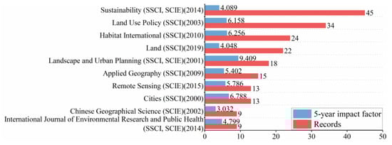
The DAUE papers in the database were published in a total of 116 different journals. Figure 3 presents the top ten most influential journals, in which 202 papers were published, accounting for about 51% of the total. The most popular journals in the field of DAUE include Sustainability, Land Use Policy, Habitat International, Land, Landscape and Urban Planning, and Applied Geography. Among these, Land Use Policy, Landscape and Urban Planning, Habitat International, and Applied Geography, with their high 5-year impact factor (IF5), have witnessed an impressive total number of DAUE-related publications thus far. In addition, DAUE case studies are mainly published in the journals of SCIE and SSCI. However, it can be observed that the average volume and IF5 of SSCI journals in the top ten journals are higher than those of SCIE journals. This indicates that although DAUE is a multidisciplinary research field, it exerts a more significant influence on social science.
Figure 3. Top ten influential journals for publications in DAUE. The number in brackets indicates the year that a DAUE paper was first published in this journal.
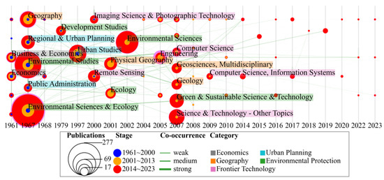
Since each journal indexed by WOS CC has been classified into at least one subject category by specific algorithms or professional experts, analysing the chronological extension of these subjects can aid in the understanding of the research domains involved in DAUE.
Figure 4 demonstrates that the subjects of these 116 DAUE-related journals can be further divided into five categories: economics, urban planning, geography, environmental protection, and frontier technology. The earliest researchers (e.g.,
[1][20]) mainly analysed the driving mechanism of urban expansion from the perspective of economics, and subsequent studies were also constantly influenced by economic theories (e.g.,
[2][21]). Later, with the continuous development of DAUE, the subjects were gradually enriched, especially those related to environmental protection and sustainable development. Since 2000, DAUE research has begun to address the subjects of “frontier technology”, such as remote sensing, engineering and computer science.
Figure 4.
Development of primary DAUE-related WOS categories.
2.3. The Transition of Involved DAUE Research Institutions
1.3. The Transition of Involved DAUE Research Institutions
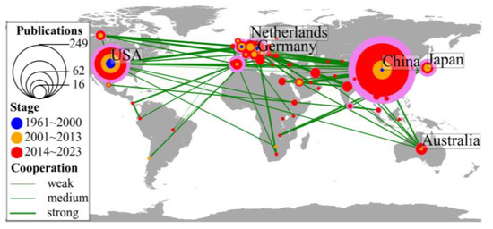
Figure 5 shows the major countries that have contributed to DAUE study, along with the cooperative network built from them. Before the year 2000, most publications came from Germany and the USA; since 2000, however, the hotspot of DAUE publications has gradually shifted to China, which has become the most important hub for the knowledge exchange and research cooperation of DAUE study (as indicated by the thickest violet outer ring). Furthermore, as shown in Table 1, Chinese institutions have conducted the highest number of DAUE studies overall, followed by institutions in the USA. Judging from the betweenness centrality of institutions, the Chinese Academy of Sciences has contributed most to DAUE publications.
Figure 5.
Cooperative network of major countries involved in DAUE.
Table 1.
Top 10 active institutions.
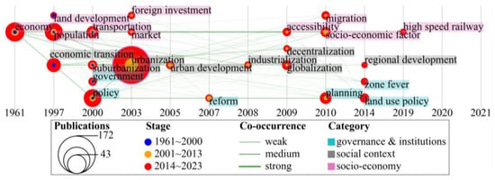
3][4][22,23]. Later, against the backdrop of China’s reform and opening up, the core research focus transferred to China, meaning that the driving factors analysed were greatly influenced by China’s urbanization strategy and policy (e.g., government, foreign investment, markets, and high-speed railway). Recently, moreover, some factors that quantify spatial interaction, such as accessibility and migration, have also attracted widespread attention.
Figure 9.
Development of themes indicating “driving factors”.
3.2. Burst Detection for Hot Themes
2.2. Burst Detection for Hot Themes
Four hot themes in DAUE are captured as burst terms: namely, economic transition, remote sensing, GIS, and cellular automata (Table 2). Among them, economic transition describes the social context of urban expansion; remote sensing is an important data source for DAUE; GIS is the technical support platform; and finally, cellular automata can be regarded as a typical application scenario of DAUE.
Table 2.
Results of burst detection.
3. Evolution of DAUE Hot Themes
2. Evolution of DAUE Hot Themes
3.1. Hot Research Themes and Their Diachronic Extension
2.1. Hot Research Themes and Their Diachronic Extension
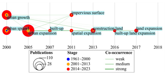
As shown in Figure 6, keywords related to urban expansion have evolved from relatively narrow to more diverse, and from implicit to explicit. For example, “urban expansion” involves more expansion patterns beyond the special form of “urban sprawl”, and clearly stresses the spatial characteristic of urban land change compared with “urban growth”. Moreover, many of the themes that developed later, such as built-up expansion, impervious surface and construction land, clarify the specific land cover change types of urban expansion in current research.
Figure 6.
Development of “keywords of urban expansion”.
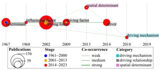
Figure 7 shows that although the specific content of driving analysis has gradually become more in-depth and complex, studies addressing driving mechanisms (how the driving factors impact urban expansion) are far fewer than those merely focusing on the driving effects/relationships (to what extent driving factors influence urban expansion). In the selection of driving factors, since approximately 2013, researchers have explicitly extended their sphere of interest from only considering city-level macro driving factors to further exploring how “spatial determinants” at the parcel or pixel level (such as distance to rivers) impact urban structure and urban land allocation.
Figure 7.
Development of themes indicating “driving analysis”.
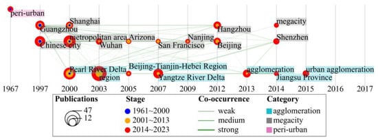
Figure 8 shows that DAUE researchers have gradually come to pay considerable attention to urban agglomerations and the megacities within them, such as Guangzhou in the Pearl River Delta, Wuhan in the Yangtze River Middle Reaches Urban Agglomeration, and Beijing in the Beijing–Tianjin–Hebei Urban Agglomeration. Increasingly complicated urban systems prompt multilevel and interactive urban expansion processes; thus, the study area tends to be diversified and multi-scale, extending from peri-urban areas to single cities, metropolitan areas or megacities, and subsequently to urban agglomerations with complex internal structures.
Figure 8.
Development of themes indicating “study area”.
Figure 9 shows that the driving factors constructed in DAUE can be classified as factors related to socio-economics, governance and institutions, and social context. The earliest involved factors such as economy, population, land development and transportation are relevant to discussions of suburbanization and urban sprawl in American and European countries [
The economic transition’s burst stage ranges from 2015 to 2017, mainly owing to the transformation of economic development during China’s reform and opening-up. Moreover, it also refers to the economic restructuring in the process of urban development
[5][24] or the economic transformation of resource-based cities resulting from the depletion of resources, e.g., coal, oil, etc.
[6][25].
GIS was applied as an important data analysis and processing tool that attracted a lot of attention in DAUE research from 2005 to 2013. Remote sensing (RS) datasets, especially Landsat data collections, were also widely employed as a new data source from 2002 to 2013. In the earlier stages of DAUE study, the advanced technologies of GIS and RS could meet researchers’ needs for data supplementation, processing, and modelling. After being mastered by more researchers, they have since become basic and indispensable research tools, and are thus no longer highlighted in new DAUE publications after 2013.
The burst stage of cellular automata (CA) ranges from 2017 to 2020. CA has a strong capability to simulate the spatiotemporal dynamics of land use change in complex urban systems. Although CA-based urban simulation places more emphasis on model accuracy, the essence of model calibration in CA is inherently related to DAUE. From approximately 2017 to 2020, some researchers in CA-based urban simulation began to pay close attention to DAUE in order to improve the performance of CA models (e.g.,
[7][8][9][26,27,28]), or to take DAUE as an auxiliary work in CA (e.g.,
[10][29]).