Your browser does not fully support modern features. Please upgrade for a smoother experience.
Please note this is a comparison between Version 2 by Sirius Huang and Version 1 by Emmanuel Chidera Alozie.
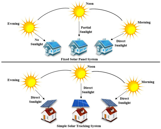
Maximum solar power can be generated only when the Sun is perpendicular to the solar panel, which can be achieved only for a few hours when using a fixed solar panel system, hence the development of an automatic solar tracking system. Over the years, different solar tracking systems have been proposed and developed.
- solar tracker
- single-axis tracker
- dual-axis tracker
- active tracker
- passive tracker
1. Introduction
Renewable energy sources are energies that come from the Sun directly, such as thermal, photochemical, and photoelectric energy, or indirectly, such as wind, hydropower, and photosynthetic energy stored in biomass, as well as other climate regulation and natural motions, such as geothermal and tidal energy; these are then converted into usable forms of energy, such as electricity, heat, and fuels [1]. The most abundant renewable energy that is directly obtained from the Sun is solar energy, which also serves as a regulator of the hydrological cycle and a source of wind energy because the Sun’s heating effect on the atmosphere causes air to move [2,3][2][3].
Solar power, also known as solar energy, can be generated by a solar panel, which largely depends on the amount of sunlight it is exposed to. Solar photovoltaic energy has a much higher installed capacity than other renewable energy concepts and technologies due to its abundance, versatility, and ease of implementation with minimal negative environmental impact in terms of land use [4,5][4][5]. Maximum solar power can be obtained only when the Sun is directly on the panel. Due to the variation of the position of the Sun throughout the day, there is a need to adjust the solar panel so that it is always aimed precisely at the Sun. A solar tracker is a device employed to operate a solar photovoltaic panel, particularly in solar cell applications, and requires a high level of precision to ensure that sunlight is directed accurately onto the power device [6]. Solar tracking systems also play an important role in the advancement of solar concentration applications such as solar-pumped lasers and parabolic concentrators [7,8][7][8]. These trackers can improve the efficiency of the overall solar photovoltaic system, reducing the size and the cost per kilowatt hour (kWh).
To increase the efficiency of photovoltaic (PV) systems, several solar tracking systems have been developed over the years.
2. Solar Photovoltaic Tracking Systems
The amount of sunlight received varies throughout the year as a result of the motions of the Earth; however, the amount of solar energy received over a certain period on a surface that is perpendicular to the radiation’s path of propagation outside of the atmosphere at the mean earth–sun distance is known as the solar constant [14][9] and can be expressed mathematically as given in Equation (1):
Figure 1.
Comparison between Fixed and Simple Solar Tracking Systems.

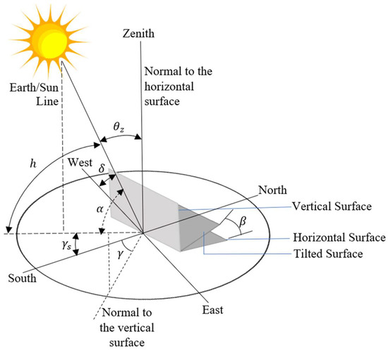
Figure 2.
Solar Angles.
References
- Ellabban, O.; Abu-Rub, H.; Blaabjerg, F. Renewable Energy Resources: Current Status, Future Prospects and Their Enabling Technology. Renew. Sustain. Energy Rev. 2014, 39, 748–764.
- Oghogho, I.; Sulaimon, O.; Egbune, D.; Abanihi, K. V Solar Energy Potential and Its Development for Sustainable Energy Generation in Nigeria: A Road Map to Achieving This Feat. Int. J. Eng. Manag. Sci. 2014, 5, 61–67.
- Mustafa, F.I.; Shakir, S.; Mustafa, F.F.; Naiyf, A.T. Simple Design and Implementation of Solar Tracking System Two Axis with Four Sensors for Baghdad City. In Proceedings of the 2018 9th International Renewable Energy Congress (IREC), Hammamet, Tunisia, 20–22 March 2018.
- Choudhary, P.; Srivastava, R.K. Sustainability Perspectives—A Review for Solar Photovoltaic Trends and Growth Opportunities. J. Clean. Prod. 2019, 227, 589–612.
- El Hammoumi, A.; Chtita, S.; Motahhir, S.; El Ghzizal, A. Solar PV Energy: From Material to Use, and the Most Commonly Used Techniques to Maximize the Power Output of PV Systems: A Focus on Solar Trackers and Floating Solar Panels. Energy Rep. 2022, 8, 11992–12010.
- Ray, S.; Tripathi, A.K. Design and Development of Tilted Single Axis and Azimuth-Altitude Dual Axis Solar Tracking Systems. In Proceedings of the 2016 IEEE 1st International Conference on Power Electronics, Intelligent Control and Energy Systems (ICPEICES), Delhi, India, 4–6 July 2016; ISBN 9781467385879.
- Costa, H.; Liang, D.; Almeida, J.; Catela, M.; Garcia, D.; Tibúrcio, B.D.; Vistas, C.R. Seven-Rod Pumping Concept for Highly Stable Solar Laser Emission. Energies 2022, 15, 9140.
- Tibúrcio, B.D.; Liang, D.; Almeida, J.; Garcia, D.; Catela, M.; Costa, H.; Vistas, C.R. Tracking Error Compensation Capacity Measurement of a Dual-Rod Side-Pumping Solar Laser. Renew. Energy 2022, 195, 1253–1261.
- Maatallah, T.; El Alimi, S.; Nassrallah, S. Ben Performance Modeling and Investigation of Fixed, Single and Dual-Axis Tracking Photovoltaic Panel in Monastir City, Tunisia. Renew. Sustain. Energy Rev. 2011, 15, 4053–4066.
- AL-Rousan, N.; Isa, N.A.M.; Desa, M.K.M. Advances in Solar Photovoltaic Tracking Systems: A Review. Renew. Sustain. Energy Rev. 2018, 82, 2548–2569.
More
