Your browser does not fully support modern features. Please upgrade for a smoother experience.
Please note this is a comparison between Version 1 by Edilson Silva and Version 2 by Rita Xu.
The upland lakes (ULs) in Carajás, southeastern Amazonia, have been extensively studied with respect to their high-resolution structural geology, geomorphology, stratigraphy, multielement and isotope geochemistry, palynology and limnology.
Os lagos de terras altas (ULs) em Carajás, sudeste da Amazônia, têm sido extensivamente estudados no que diz respeito à sua geologia estrutural de alta resolução, geomorfologia, estratigrafia, geoquímica de multielementos e isótopos, palinologia e limnologia.
- upland lakes
- Carajás mountain range
- landscape evolution
1. Introductiçãon
TheOs upland lakegos de terras altas (ULs) in the Brazilian Amazon arena Amazônia brasileira são formas de relevo singular mid-es de média altitude (fromde 400 m toa 800 m) landforms formed over iron and ironformadas sobre crostas lateríticas de ferro e ferro-aluminous lateritic crusts as a result of cyclic tectonic, weathering and thsas como resultado de processos tectônicos cíclicos, intemperismo e erosional processes under tropical climate conditionão em condições climáticas tropicais [1][2][3][1,2,3]. ThEstese lakes are lagos são classified as active and inactive lake systems, the lattercados como sistemas lacustres ativos e inativos, corresponding to upland swamendo este último a pântanos de terras altas [4].
A deposição [4].
Thde sediment deposition in ULs is highly em ULs é altamente influenced by the natural and local chaiada pelas caracteristics of the catchment basinísticas naturais e locais da bacia hidrográfica, including theindo a geology, ia, a cobertura vegetation cover, primaryl, a productivity of thetividade primária da bacia central basin [5][6][7] [5,6,7] e a idande relative lake agea do lago [3]. DApespite thear da relativea homogeneity, the drainage basins in southeastern Amazoniadade, as bacias hidrográficas do sudeste amazônico apresentam locally present various lithotypes andmente vários litotipos e cenários geomorphological settingsfológicos. Consequently, they hold plant communities with difemente, eles mantêm comunidades vegetais com diferent structures andes estruturas e compositionções [8]. MAlém disso, oreover,s processos diagenetic processes have modifiedéticos modificaram a composição dos sediment compositionos [5]. All Todof these factors haves esses fatores têm controlled the geochemical andado as características geoquímicas e limnological characteristics of these ULs over timeógicas desses MSs ao longo do tempo [9][10][9,10].
Th
Os depósitos Qquaternary deposits in Amazonian ULs have difários em ULs amazônicos têm espessuras diferent thicknesses. Some display continuouses. Alguns apresentam sedimentation, asção contínua, como evidenced in thiado nas serras de Seis Lagos (northwestern Amazooeste da Amazônia), Maicuru/Maraconaí (central-northeastern Amazonia) ando-nordeste da Amazônia) e Carajás (southeastern Amazonia) mountain rangeudeste da Amazônia) [4,11,12,13,14,15,16,17,18]. As [4][11][12][13][14][15][16][17][18]. The investigationções conducted at theserealizadas nessas localities have allowed an evaluation of the effects of the lastdades permitiram avaliar os efeitos dos últimos períodos glacial ande interglacial periods onna Amazônia tropical Amazonia. ULs may become more similar to terrestrial. Os ULs podem se tornar mais semelhantes aos habitats during theterrestres durante o período negative watero de balance periodço hídrico produced by prolonged water zido pelo estress, which may affect the ecological attributes of water-e hídrico prolongado, o que pode afetar os atributos ecológicos da biota dependent biote da água [19][20][19,20]. InEm contrast, moree, ULs mais resilient ULs may act ases podem atuar como microrefuges for suchrrefúgios para esses organisms. Thus, both the physical and biological aspects, as well as their dynamic nature, must be carefully evaluated over shorter (annual toos. Assim, tanto os aspectos físicos quanto biológicos, bem como sua natureza dinâmica, devem ser cuidadosamente avaliados em escalas de tempo mais curtas (anuais a decadal) and longer (century to millennial) time scalesis) e mais longas (século a milenar).
Geologyia, Physiography andFisiografia e Climate
ThA área de study area is located in the eastern portion ofestudo está localizada na porção leste da Província de Carajás Province, southeastern Amazo, sudeste da Amazônia (Figure 1a 1), e and the geology isia é represented byada por: (1) Mesoarcheanséries tonalite–a-trondhjemite–a-granodioriteo mesoarqueano (TTG) series and e unidades granulitic units (íticas (Ortogranulito Xikrin-Cateté Orthogranulite) [21][22][36,37]; (2) NSeoarcheanquências metavoulcano-sedimentary sequencees neoarqueanas [23][38]; (3) NeRoarcheanchas intrusive as neoarqueanas [39] e corpocks [24] estratificand mafic–os máfico-ultramafic stratified bodieáficos [25][40]; (4) PaleoproterRozoicchas sedimentary rockes [26]; pand (5) Paleoproterozoic as [41]; e (5) intrusões anorogeênic intrusionas paleoproterozoicas [27][42].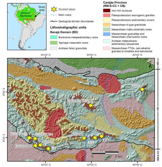
Figurea 1. UMapper map with study area in the a superior com área de estudo no context of South America and Amazon Rainforest (green area: forest cover, red areo da América do Sul e Floresta Amazônica (área verde: cobertura florestal, áreas vermelhas: deforestation). Lower map with smatamento). Mapa inferior com legendas associated legends: geological map showing the main lithological units of thdas: mapa geológico mostrando as principais unidades litológicas da cordilheira de Carajás mountain range in the Brazilian Amazon. The studied lakes are located in the, na Amazônia brasileira. Os lagos estudados estão localizados nas crostas lateritic crusts in the Sul (active lakeíticas do Sul (lagos ativos: Três Irmãs, Amendoim, Violão; filled lakelagos cheios: R1, R2, R4, R5), Norte (filled lakelago cheio: Trilha da mata), Leste (active lakelago ativo: lagoa Serra Leste— – LSL), Tarzan (active lakelago ativo: Tarzan) ande Bocaína (filled lakelagos cheios: LB3, LB4) plateaus; Província de Carajás (RM + S-CC + CB: Rio Maria + Sapucaia + domínios Canaã dos Carajás + Bacia do Carajás).
2. LakProcessos de Formation Prção do Lagocesses
The
As crostas lateriític crusts of the Sul mountain range are displaced by sets of E–W faults that are as da cordilheira do Sul são deslocadas por conjuntos de falhas E-W que são responsible for the morphology of the plateaus, NW–SE normal faults to NE–SW fractures, and áveis pela morfologia dos planaltos, falhas normais NW-SE para fraturas NE-SW e falhas sinistral—normal fault-normais [3]. TheA dissolução partial dissolution of thecial da crosta lateritic crust ítica oriented by these fractures and faultada por essas fraturas e falhas formed karst-like features, such as caves, sinkholes and underground streamou características cársticas, como cavernas, sumidouros e córregos subterrâneos [1]. AUma series of fault reactivationérie de reativações de falhas promoted the collapse of blocks along theveu o colapso de blocos ao longo das falhas normal faults, which formed the shallow upland lakes.
This, que formaram os lagos rasos de terras altas. A dissolução parcial da crosta laterítica e o escoamento shallow-water seismicintenso, particularmente durante a estação chuvosa, favorecem o transects and their reflection porte e a deposição de sedimentos clásticos no lago [44]. Em alguns chasos, a sobrecaracteristics, as well as the sedimga da base dos lagos, juntamente com reativações de falhas, promoveu novos colapsos e aumentou o espaço de acomodação dos lagos [44].
Os transenct cores, allowed researchers toos sísmicos em águas rasas e suas características de reflexão, bem como os núcleos sedimentares, permitiram identify theicar a geometry of the seia das unidades sismostratigraphic unitáficas deposited in thadas nas ULs de Carajás ULs[3] [3] (Figurea 2). TheAs acoustic features arecaracterísticas acústicas estão associated with the morphometry and morphology of the bedrockdas à morfometria e morfologia do reflector, debris flows, synsedimentarytor do leito rochoso, fluxos de detritos, estruturas deformational structures, planecionais sinsedimentares, refletores plano-parallel reflectors and multipleelos e múltiplos reflectors from the watertores da interface água-substrate interface o (Figurea 2). TheA interface between the bottomentre os sediments and theos de fundo e a crosta lateritic crust is marked by a total acousticítica é marcada por uma reflection of the crust, whichxão acústica total da crosta, que produces strong-amplitude lake-bottom multiples (bedrock reflectors). The basal fine-grained deposits located near the main drainage inflows z múltiplos de fundo de lago de forte amplitude (refletores de rocha). Os depósitos basais de grão fino localizados perto das principais entradas de drenagem correspond to the fault-collapsed, basinwardem aos clinoformes de prograding clinoformação em direção à bacia colapsados por falhas related to thecionados aos ventiladores delta fans. Underflow . Os processes areos de subfluxo são responsible for carrying fine-grained particles toward the lakeáveis pelo transporte de partículas de grão fino em direção ao depocenterro do lago, interrupted byompidas por leitos siderite beds. The top deposits are related to massive. Os depósitos superiores estão relacionados à lama maciça aggradatcional and structureless mud with some scattered peat fragmente sem estrutura com alguns fragmentos de turfa dispersos (Figurea 2). ThiIss facies ano cria um arrangement thatjo que produces fining and thinning upward cycles, which might vary in thicknessz ciclos ascendentes de aletamento e desbaste, que podem variar em espessura depending on the rate of the accommodation spaceendo da taxa do espaço de acomodação.
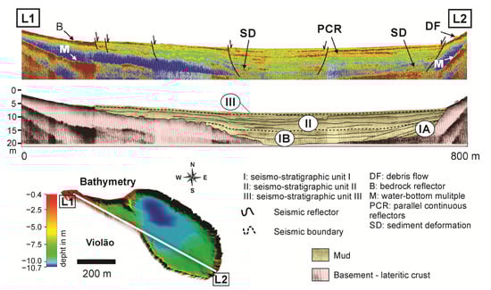
Figurea 2. NW–SETransectos sísmicos longitudinal seismic transects showing the different observed morphologic levels,is NW-SE mostrando os diferentes níveis morfológicos observados, unidades depositional units, basement and multiple reflectors, and fault. The secionais, refletores basais e múltiplos e falha. A interpretação sismostratigraphic interpretation in the lower part of the figure. Upper figure (shallow seismic image), middle figure (seáfica na parte inferior da figura. Figura superior (imagem sísmica rasa), figura média (interpretação sismostratigraphic interpretation) and loweráfica) e figurea inferior (legends and location of the seismic profile in the lake bathymetryas e localização do perfil sísmico na batimetria do lago).
3. Geologia de Surface Geology and perfície e Geobotany of the Catchment Basinânica das Bacias Hidrográficas
The
As crostas lateriític crusts of the study area are as da área de estudo são geneticallymente classified as structured (iron orecadas como crostas estruturadas (minério de ferro), detrital and Al-rich crustsíticas e ricas em Al [28][48] (Figurea 3). SCrostas estructured and detrital crusts were formed by theturadas e detríticas foram formadas pela lateritization of BIF and the weathering of the structured crustsção do BIF e pelo intemperismo das crostas estruturadas, respectively, and containamente, e contêm hematitea, magnetitea, goethite and secondarilya e, secundariamente, minerais de quartz and clay mineralso e argila [9]. TheEssase crusts are generally thick and more crostas são geralmente espessas e mais resistant tentes ao intemperismo modern weatheringo, forming only Petric Pando apenas plinthosols/Petroferric Asolos petrânicos/acrustox, which petroférricos, que dominate the higherm os níveis topographic levels. Conversely, the Al-rich crusts formed by theáficos mais altos. Por outro lado, as crostas ricas em Al formadas pela lateritization of mafic rocks are richer in clay ção de rochas máficas são mais ricas em minerals andis argilosos e gibbsitea, especially close to thmente perto do horizonte saprolite horizon. Additionally, they are lesólito. Além disso, são menos resistant to weathering and occur on lower quotas than structured and detrital crusts. Thus, these crusts mayentes ao intemperismo e ocorrem em cotas mais baixas do que crostas estruturadas e detríticas. Assim, essas crostas podem produce thicker soils (i.e.zir solos mais espessos (ou seja, Ferrasols/OxisolLatossolos).
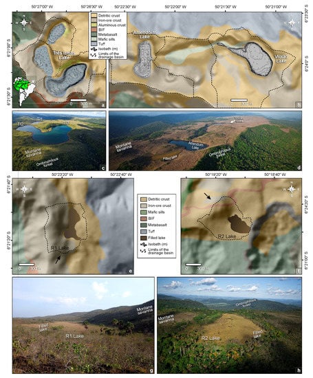 The detrital and structured crusts have some peculiar characteristics, including shallow, patchy and acidic soils, with low water retention and nutrient availability and high insolation and temperature [30][31][49,50], which allowed the widespread development of canga vegetation and hindered the colonization of tree species (Figure 3a–d), such as SDF and HETF [8][30][8,49]. This interpretation is supported by the high δ13C values of the canga vegetation compared to soils in neotropical forests, which are related to more pronounced water shortages in cangas than forests [32][51]. Mafic sills and dikes are predominant on the slopes of the Carajás mountain range and marginal to the Três Irmãs and Violão lakes, extending toward Amendoim Lake (Figure 3a–d). Palms and macrophytes occur extensively in filled lakes (Figure 3e–h). Moreover, macrophytes, especially Isoëtes cangae, which is a very rare and endemic species, are widely found at the bottom of Amendoim Lake at depths up to 7 m [33][52]. The dominant plant species of each physiognomy are described in Table 1.
Figure 3. (a,b) Digital elevation model (DEM) integrated with bathymetric data showing the western and eastern portions of the Serra Sul Plateau and the main lithotypes described in the catchment basins of active ULs. Aerial photograph of (c) Três Irmãs (TI1, TI2 and TI3), (d) Amendoim (AM) and Violão lakes (VL). (e,f) DEM showing the main lithotypes described in the catchment basins of filled ULs, also a detail (black arrow) for the direction of view of photo (e,f). (g,h) Aerial photograph of the filled ULs.
Table 1. Main plant species of canga vegetation, SDF (semideciduous tropical dry forests) HETF (humid evergreen tropical forest) and filled lakes according to their based on [9][34][9,30], reviewed according to Carajás Flora Project [35][53].
| Vegetation Type | Species | |||||||||||||||||||||||||||||||||||||
|---|---|---|---|---|---|---|---|---|---|---|---|---|---|---|---|---|---|---|---|---|---|---|---|---|---|---|---|---|---|---|---|---|---|---|---|---|---|---|
| Canga | Dyckia duckei | (Bromeliaceae), | Ipomoea marabensis | (Convolvulaceae), | Erythroxylum nelson-rosae | (Erythroxylaceae), | Bauhinia pulchella | , | Mimosa acutistipula var. ferrea | and | M. skinneri var. carajarum | (Fabaceae), | Byrsonima chrysophylla | (Malpighiaceae), | Norantea goyasensis | (Marcgraviaceae), | Tibouchina edmundoi | and | Pleroma carajasensis | (Melastomataceae), | Sobralia liliastrum | (Orchidaceae), | Axonopus carajasensis | , | Panicum millegrana | , | Paspalum cangarum | , | P. carajasense | and | Sporobolus multiramosus | (Poaceae), | Borreria | (Rubiaceae), | Vellozia glauca | (Velloziaceae) | , Callisthene microphylla | (Vochysiaceae). |
| SDF | Licania blackii | (Chrysobalanaceae), | Aparisthmium cordatum | and | Maprounea guianensis | (Euphorbiaceae), | Myrcia splendens | (Myrtaceae), | Henriettea ramiflora | , | Miconia chrysophylla | (Melastomataceae), | Matayba inelegans | (Sapindaceae). | ||||||||||||||||||||||||
| HETF | Tapirira guianensis | (Anacardiaceae), | Guatteria punctata | and | G | . | tomentosa | (Annonaceae), | Oenocarpus distichus | (Arecaceae), | Cordia sellowiana | (Boraginaceae), | Licania laxiflora | (Chrysobalanaceae), | Deguelia negrensis | , | Pseudopiptadenia suaveolens | (Fabaceae), | Emmotum nitens | (Icacinaceae), | Sacoglottis mattogrossensis | (Humiriaceae), | Mezilaurus itauba | (Lauraceae), | Miconia piperifolia | (Melastomataceae), | Myrcia silvatica | (Myrtaceae), | Neea ovalifolia | (Nyctaginaceae), | Matayba arborescens | (Sapindaceae), | Erisma uncinatum | (Vochysiaceae). | ||||
| Filled lakes | Mauritiella armata | (Arecaceae), | Eleocharis pedroviane | , | Cyperus, Scleria | (Cyperaceae), | Hydrochorea corymbosa | (Fabaceae), | Miconia alternans | (Melastomataceae), | Styrax griseus | (Styracaceae). |
4. Modern Sedimentation Patterns: Basin Morphology and Source-to-Sink Relationship
The active Carajás ULs have mid-altitude ranges (695–725 m), very small surface areas (<0.5 km2), shallow to very shallow depths (<10 m: mean depth) and catchments with relatively high declivities (>20° and maximum of ~60°) [36][21]. The Violão (VL) and Amendoim (AM) lakes are separated by an intermediate basin that prevents any surface connection of water between them (Figure 3b). The catchment of Amendoim Lake was composed of two lakes (Figure 3d), but the smaller lake, located in the western portion, was progressively filled by detritic and organic sediments and currently represents a filled lake (swamp) colonized by macrophytes [34][30]. In contrast, the three lakes (TI1, TI2 and TI3) of Três Irmãs are connected, and the water flow follows the elevation gradient from TI1 to TI3 (Figure 3c), forming a small waterfall between the lakes [36][21].
The statistical distribution of the major and trace elements in the lake sediments shows that there is considerable variation in the chemical elements among the lakes, which is reinforced by the Kruskal–Wallis test, which indicated p values of <0.05 for most of the elements. Si was the highest in VL and the lowest in TI2, which had the highest total organic carbon (TOC) values. The concentrations of Al, P, Ti and Zr are mainly enriched in TI1, followed by VL. This enrichment is due to the presence of Al-enriched lateritic crusts (including basalts) and soils. When compared to upper the continental crust (UCC) values, Fe is highly enriched in all of the lake sediments, followed by P and Se, while the concentrations of Na, K and Ca are highly depleted. The strong depletion of these mobile elements is due to intense chemical weathering in the source areas, which is an indication of a typical lateritic environment.
Integrating the geochemical data from active ULs, based on principal components analysis (PCA), five major groups of geochemical associations are distinguished (Figure 4a), with the major detritic groups being similar to the catchment basin laterites [29][25]. The Ti-Zr-Hf-Y-Nb-HREE (Gp-1) corresponds to resistant minerals, which possibly remained stable during lateritization, while the different behavior of the LREE (Gp-2) relative to the HREE indicates their relative mobility during laterite formation and reprecipitation by REE-bearing minerals. The Al-Sc-V-Cr association (Gp-3) in the sediments reflects the signature of the local country rock, such as mafic sills. TOC-SO3-Hg-Se (Gp-4) is controlled by organic matter, while the Fe-P-Mo-As-Zn (Gp-5) in the sediments is influenced by Fe-oxyhydroxide precipitation.
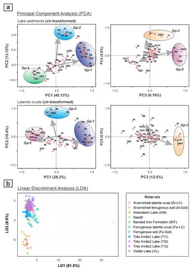
Figure 4. Principal component analysis (PCA) biplot of PC1 vs. PC2 and PC3 vs. PC4 for active lake sediments and catchment lateritic crusts, based on centered log-ratio (clr)-transformed data, showing the different geochemical associations and the major detrital signatures that are similar among them (a); and linear discriminate analysis (LDA) showing the distribution of lake sediments and the relationship with catchment basin materials (b).
The detritic association of Gps 1, 2 and 3, similar to the catchment rocks indicates a strong influence on the catchment basin lithology and laterization processes. The multivariate analysis, such as the linear discriminant analysis (LDA), further indicates that the detritic sediments are not directly derived from the parent rocks (Figure 4b), but are well correlated with the underlying weathered crusts (mainly ferruginous) and soils, while the ferruginous laterite crusts are the major source of detrital sediments. This inference demonstrates that lake sediments can be a potential tool for identifying and describing the catchment processes and basin lithology.
PCA performed on the centered log-ratio (clr)-transformed data was also employed to evaluate the relationships of the geochemistry of the bottom sediments among the filled lakes (Figure 5). The Bocaína (LB3 and LB4) lakes were mostly differentiated from the others as they loaded weakly positively on the PC2. This feature is related to the dominance in that area of Al-enriched lateritic crusts that were formed mostly from metavolcanic rocks. Thus, the geochemical signature of the Bocaína lake sediments shows higher concentrations of Al, Ga, Ti, Cr, V, Sc and REEs [37][24]. In these sediments, there is different geochemical behavior between the LREE and HREE, which is due to their different mobilities during lateralization [29][25]. Similar high enrichment of the detritic elements, such as Al, V, Ga and Cr, which are moderate to highly loaded on PC2, were also observed in the lakes from the Norte mountain range—Trilha da Mata Lake (LTM, LTP and LTD).
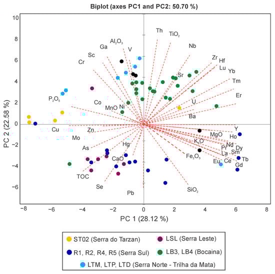
Figure 5. Principal component analysis (PCA) performed on centered log-ratio (clr)-transformed data for all filled lakes (sediment cores).
The sediments from Tarzan Lake (ST02) show mostly negative loading on PC1 and positive loading on PC2. This result is partly associated with Fe, suggesting that the crusts are similar to the Sul mountain range, but the high enrichment of Co, Cu, Mo, P, Cr and P in these sediments indicates a strong influence of mafic rocks, which is not exactly similar to that observed in the Bocaína lake sediments.
The sediments from Leste Lake (LSL) are negatively loaded on both PC1 and PC2 and seem very different from the sediments of the other lakes. The high enrichment of TOC in the detritic sediments of these lakes points to the control of different geomorphological and lithological characteristics of the basin. Moreover, in the Leste Lake sediments, As is more enriched, similar to the sediments from Tarzan lakes, suggesting the presence of sulfide minerals in the catchment rocks.
The filled lakes in the Sul mountain range (R1, R2, R4 and R5) have widely variable geochemical compositions, with the samples being positively and negatively loaded on PC1. Most of them are associated with Fe, as well as Si, thus indicating that the crusts developed mainly from iron formations, which have significant concentrations of Fe, while the Si contribution comes from BIF.
All of this fundamental knowledge of the modern lake sedimentary processes of Amazonian ULs and their catchment interactions can thus provide crucial insights for the interpretation of source—sink relationships and paleoclimate reconstruction.
5. Environmental Influences on Limnology and Water Quality
Regarding the ULs in the Carajás region, the lake waters are mostly acidic (avg. pH of 4.9–5.9), with high total Fe (up to 1.52 mg/L) and low SO42− and other metal concentrations [10]. The low pH can be explained by the trivial level of carbonate minerals and the total dominance of ferruginous lateritic material in the catchment, as well as high sedimentary organic carbon in the lake bottom, which releases CO2 and H2S via bacterial decomposition, making the water acidic [38][54]. The high levels of Fe in the lake water are related to the weathering and erosion of the catchment ferruginous soils and lateritic crusts. This evidence indicates that the catchment geology is the dominant factor influencing the lake water chemistry.
These ULs are shallow, weakly stratified (Figure 6a) and classified as polymictic, which controlled the vertical mixing of the limnological parameters [10]. Although the water quality index (WQI) shows good water quality and high similarity among the studied lakes, the trophic state of these lakes varied significantly between ultraoligotrophic and eutrophic (Figure 6b), with lower values observed for Amendoim Lake [10]. High trophic states are due to nutrient concentrations, mainly total phosphorous (TP), promoting algal growth. The sources of TP for these lakes are associated with the presence of mafic rocks and caves with high guano volume [7][10][7,10]. Although Chl-a and cyanobacteria are mainly influenced by nutrients such as TP, this is not the case for these lakes; rather, they are controlled by additional factors, such as the seasonal climate conditions, catchment lithology specificities and lake morphology [10].
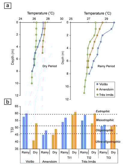
Figure 6. Vertical temperature profile in Violão, Amendoim and Três Irmãs lakes during the dry and rainy seasons showing the thermal stratification of the lakes (a), and trophic state index (TSI) of the lakes during both dry and rainy seasons (b), showing the significant variation in trophic state among lakes.
The Phytoplankton taxa in the lakes are characterized by small Chroococcales groups and desmids, together with filamentous algae, which are more commonly observed in the dry season. The Phytoplankton composition also varies among the lakes based on the differences in the water depth and nutrient concentration [10]. The studies conducted thus far have contributed to understanding the common limnological characteristics of the Amazonian ULs and their role in controlling the geochemical distribution of the elements and diagenetic processes in the sediments.