Your browser does not fully support modern features. Please upgrade for a smoother experience.
Please note this is a comparison between Version 1 by Jeremy Wang and Version 2 by Sirius Huang.
Since the shorelines are important geographical boundaries, monitoring shoreline change plays an important role in integrated coastal management. With the evolution of remote sensing technology, many studies have used optical images to measure and to extract shoreline. However, some factors limit the use of optical imaging on shoreline mapping. Considering that airborne LiDAR data can provide more accurate topographical information, they are used to map shorelines. There are two major types of airborne LiDAR systems that are commonly used in shoreline area surveys: the airborne laser topographic scanning system (ALT) and the airborne laser bathymetric scanning system (ALB).
- airborne LiDAR
- laser scanning system
- shoreline mapping
- shoreline extraction
1. Introduction
Shorelines are the physical interface that separates the land from the ocean. This interface is surrounded by a wealth of ocean resources. The desired economic development forces most coastal countries around the world to exploit these ocean resources [1]. Approximately 50% of the population around the world lives within 100 km of a shoreline, and aims to tap into these ocean resources along the shoreline for economic and social benefits [2][3][2,3]. However, natural factors and excessive human intervention have caused varying degrees of damage to coastal zones, making it somewhat vulnerable, especially the evidence that has been demonstrated in shoreline changes.
Due to the dynamic changes of shorelines depending on the temporal and spatial scale, the shoreline is not an invariable line. Thus, coastal scientists undertake studies to analyze variability and erosion-accretion trends for shorelines. Traditional measurement techniques such as ground surveys or aerial photogrammetry can be used for measuring the coastal beach erosion to track fluctuations in shoreline position [4]. However, there are some limitations of the traditional shoreline measurement, including limited spatial resolution, large expense, time-consuming, and the requirement of a large amount of well-trained manpower [4][5][6][7][4,5,6,7]. With the progress of remote sensing technology, such as optical, microwave, and Light Detection and Ranging (LiDAR) sensors, high precision coastal maps can be obtained accurately and efficiently [4][8][9][4,8,9], which have been applied in practical scenarios including the generation of accurate navigation charts, the determination of marine boundaries, the monitoring of shoreline erosion and accumulation, and delineating the intertidal zones, wetlands, and other coastal ecosystems [10][11][10,11].
In terms of shoreline measurement, optical satellite remote sensing and airborne LiDAR have been widely used in modern surveying [12][13][14][15][16][17][18][19][12,13,14,15,16,17,18,19]. A comparison between optical satellite remote sensing and airborne LiDAR is shown in Table 1. Optical satellite as passive sensor technology requires daylight and optimal weather conditions for shoreline measurement. Otherwise, the collection of optical images would be affected by adverse weather conditions, such as haze, clouds, and poor light conditions [20]. Meanwhile, it may be difficult to acquire suitable images for the study area due to the revisit of time, depending on the operational cycle of the satellite [21]. In addition, most common optical images lack vertical information [22], which cannot deal with the various tide-level results. Thus, the shoreline extracted is instantaneous. When studying the trend of shoreline change, we need to correct the instantaneous shoreline using the tidal level data. In addition, different coastal types also can affect the accuracy of optical satellite imagery-derived shorelines [23].
Table 1.
Comparison of airborne LiDAR and optical satellite remote sensing.
| Characteristic | Airborne LiDAR | Optical Satellite | |
|---|---|---|---|
| System | Sensor technology | Active | Passive |
| Performance | Spatial Resolution | Relatively High | Relatively Low |
| Dataset scale | National and regional | Global | |
| Vertical accuracy | High | Low | |
| Temporal resolution | Low | High | |
| Operation Restriction | Lighting conditions | Day and Night | Daytime |
| Cloud condition | No impact | Impact | |
| Terrain Condition | No impact | Impact | |
| Data | Type | Point cloud | Raster Imagery |
| Mapping Quality | Spatial information | Three-dimensional | Two-dimensional |
| Shoreline extraction | Directly extract from point cloud or Image-processing techniques | Visual interpretation or image-processing techniques | |
In contrast, airborne LiDAR, as an active remote sensing technology, has the advantage of high speed and high precision of measurement, and it is not affected by lighting conditions [24]. More importantly, the real-time three-dimensional spatial information can be highly automated and captured to support rapid deployment in the coastal zone, due to the ability of LiDAR allowing for the observation of targets without terrain limitation [12][25][12,25]. For example, the U.S. Army Corps of Engineers has developed the SHOALS project to map coastal areas in a large-scale region [26], and has developed the Coastal Zone Mapping and Imaging LiDAR (CZMIL) system to improve survey efficiency and system reliability in coastal areas [27]. Canada implemented a national LiDAR project called FUDOTERAM to assess topographic and bathymetric elevation characteristics in 2006 [28]. The latest news collected is that National Oceanic and Atmospheric Administration (NOAA) has provided over 800 new coastal LiDAR datasets covering 1.4 million km2 in 2022 (https://www.opentopography.org/news/noaa-coastal-lidar-data-now-available-academic-users-through-opentopography (accessed on 8 December 2022)). Moreover, LiDAR technology has another advantage that can be used as a standalone measurement device or that can combine with with other remotely sensed devices. However, it is a pity that the temporal resolution of airborne LiDAR is closely related to the project requirements, where the operation time depends on the project period (Table 1). It is lower than that of optical satellite remote sensing, which operates all day long and visits regularly, such as SPOT [14].
The investigation of shoreline changes is one of the main applications using remote sensed devices in coastal mapping. However, shorelines changes over time with the tidal and complex coastal environment increase the difficulty of mapping in coastal areas. The shoreline extracted from the airborne LiDAR data provides an efficient, highly accurate, useful, and fast solution [29][30][29,30]. This is because it provides not only more accurate geometrics information for the topography, but it also provides a richer radiometric information such as the intensities from different channels, which help to better distinguish between the water and land [24][31][24,31]. Although airborne LiDAR demonstrates the good performance of shoreline measuring according to some studies [32][33][34][32,33,34], its main drawback is that it cannot directly obtain the positions of shorelines due to it storing and organizing the data as unordered discrete points which are also called point clouds [12]. Thus, how to appropriately adopt and accurately use the airborne LiDAR data for shoreline extraction is an important topic for monitoring shoreline changes.
2. Airborne LiDAR Systems Development and Datasets Availability for Shoreline Mapping
Airborne LiDAR consists of a series of components, of which there are three core pieces of equipment, namely, laser scanning system, differential GPS/GNSS, and Inertial Measurement Unit (IMU). This system allows for the instant collection of a three-dimensionality (3D) point cloud by capturing the reflectance energy emitted by the sensor [35][36][37][36,37,38]. As the most important equipment of airborne LiDAR, the laser ranging system makes it easy to be operated both day and night, which undertakes the role of sending and receiving laser signals. It can detect and record laser energy in different ways, including discrete-return, full-waveform, and photon-counting. Although the theory of laser was first introduced by Townes and Schawlow in 1958 [38][39]; it was not widely used until the 1990s. This development allows airborne LiDAR as an ideal choice for measuring shoreline environmental parameters, especially for the topography, ground objects, and vegetation classification in both surface and submerged areas [39][40]. More stable data of shoreline measurement (e.g., datum-derived contours) from airborne LiDAR are obtained than in High Water Line (HWL) measurements from aerial photographs, which benefit by being not subject to the effects of short-term fluctuations in wave energy and water level [40][41].2.1. Airborne Laser Topographic and Bathymetric Scanning System for Shoreline Measurement
Currently, there are two major types of airborne LiDAR systems that are commonly used in shoreline area surveys, including the airborne laser topographic scanning system (ALT) and the airborne laser bathymetric scanning system (ALB). Table 2 and Table 3 summarized the development of airborne laser scanning systems, including ALT and ALB, which were used in shoreline mapping and monitoring applications.Table 2.
A summary of the airborne laser topographic scanning system (ALT) used in shoreline-related studies.
| Year | Sensor | Laser Range | Pulse Repetition Frequency | Vertical Accuracy | Horizontal Accuracy | Operation Altitude | |||||||
|---|---|---|---|---|---|---|---|---|---|---|---|---|---|
| Year | Sensor | Laser Range | Related Studies | ||||||||||
| Pulse Repetition Frequency | Depth Accuracy | Vertical Accuracy | Horizontal Accuracy | Operation Altitude | Related Studies | ||||||||
| 1996 | ATM | 1064 nm | 10 kHz | 0.15 m | 0.8 m | Typically 400–800 m | |||||||
| 2001 | EAARL | Coastal mapping and monitoring | [ | 13 | ] | [ | 41][42][13,42,45] | 532 nm, shoreline extraction [43 | 3–10 kHz] | [ | 5–10 cm44][43,44] | ||
| <1 m | Nominal 300 m | Shoreline mapping | [ | 49 | ] | [ | 65 | ][62,63], coastal monitoring [66][64] | 1998 | Optech ALTM 1210 | 1100 nm | Max 10 kHz | 0.15 m |
| 2003 | Optech SHOALS 1000T | 0.8 m | 532 nm + 1064 nm | Max 10 kHz | 0.52+ | Up to 1.2 km | (0.013×depth)2−−−−−−−−−−−−−−−−−−√ m | 2.5 m (1σ)Shoreline mapping [40][41] | |||||
| 200–400 m | Seafloor mapping | [ | 67 | ] | [ | 78 | ] | , shoreline mapping [ |
Diagram of waveform reflected from ALB.
2.2. Datasets Availability in Coastal Areas
Under the environment of more and more governments, organizations, companies willing to share, and open data, more and more countries provide the airborne LiDAR data online. After broad searching, some available datasets are summarized in Table 4. The main resources of this table are from OpenTopography (https://www.opentopography.org/ (accessed on 8 December 2022)), and the government websites. These datasets are usually initiated by national or regional projects, and are conducted by the lower-level municipal governments or organizations such as provinces or states. For example, the province New Brunswick is in the eastern coastal area of Canada, and Airborne Lidar data were collected from 2015 to 2018 within the province, which fully covered the coastal area of the whole province and is open access. (https://geonb.snb.ca/li/ (accessed on 8 December 2022)).Table 4.
A summary of available airborne LiDAR datasets in coastal area.
| Country | Data Format | Spatial Resolution | Surveyed Year | Coverage | Additional Note | Reference | |||||||||||||
|---|---|---|---|---|---|---|---|---|---|---|---|---|---|---|---|---|---|---|---|
| Australia | Airborne LiDAR-derived DTM | 5 m | 2001–2015 | 45,000 km2 | Cover Australia’s populated coastal zone; floodplain surveys within the Murray Darling Basin, and individual surveys of major and minor population centers. | https://www.ga.gov.au/ | |||||||||||||
| Canada | Airborne LiDAR point clouds | 1–2 m | 2013–present | Partially covered eastern coastal area and Great Lakes area | Provincial-based nationwide project covering most major cities. | https://open.canada.ca/ | 49 | ][62] | |||||||||||
| 1999 | Optech ALTM 1225 | 1024 nm | Max 25 kHz | 0.15 m | Up to 2 km | Coastal application [45][67] and shoreline extraction [46][47][56,68] | |||||||||||||
| 2006 | Optech SHOALS 3000T-H | 532 nm + 1064 nm | 20 kHz | 0.25 m (1σ) | 0.25 m (1σ) | 2 m (1σ) 1/500 × altitude (1σ) |
300–400 m | Coastal mapping [68][79] and shoreline extraction [69][80] | |||||||||||
| Japan | Airborne LiDAR point clouds | Just launched | 35,000 km of coastline | Map of the Sea Project launched in 2022 | 2000 | Optech ALTM 1233 | 1100 nm | Max 33 kHz | Coastal application | ||||||||||
| https://www.jha.or.jp/en/jha/ | (accessed on 8 December 2022) | 2010 | Optech CZMIL | [ | 532 nm + 1604 nm | 10 kHz (green), 70 kHz (infrared) | 0.32+(0.013×depth)2−−−−−−−−−−−−−−−−−−√ m, 245][67], Shoreline changes and features extraction [32], Beach segmentation [48][69], Inland water boundary extraction [21] | ||||||||||||
| σ | , 0–30 m | 0.15 m (2 | σ | ) | 1 m (2 | σ) | Nominal 400 m, up to 1 km | Coastal mapping and monitoring [15][ | |||||||||||
| Scotland | Airborne LiDAR point clouds | 4 points/m 2 | 27 | ] | 2011–2021 | [ | 15 | [70],27,65] | More than 45,078 km2 in total area | 5 phases, covering the partial coastal area | https://remotesensingdata.gov.scot (accessed on 8 December 2022) | 2002 | Optech ALTM 2050 | 1064 nm | Max 50 kHz | 0.15 m (1200 m AGL) | |||
| USA | Up to 2 km | Shoreline mapping | [ | 49 | ] | [ | 50 | ||||||||||||
| 2015 | Leica Chiroptera II | ] | 515 nm + 1064 nm | 35 kHz (green), 500 kHz (infrared) | [ | 0.15 m | 2 cm (1σ)62 | 0.20 m (1σ) ,70] |
|||||||||||
| (400 m AGL) | 400–600 m, up to 1.6 km | Coastal mapping | Airborne LiDAR point clouds | 0.15–3 m | 1999–present | [ | 71 | Fully covered inland USA coastal area and Great Lakes area, partially covered Alaska[71] | |||||||||||
| ] | [ | 58 | ] | and shoreline monitoring | [ | 72 | ] | [81]) | Surveyed by the U.S. Army Corps of Engineers, NOAA, and U.S. Geological Survey | https://coast.noaa.gov/digitalcoast/data/jalbtcx.html (accessed on 8 December 2022) | 2003 | Optech ALTM 30/70 | 1064 nm | Max 70 kHz | 0.15 m (1200 m AGL) | 1/2000 × altitude (1σ) | Up to 3 km | ||
| 2018 | Riegl VQ-880G | 532 nm + 1064 nm | Max 550 kHz | 0.32+(0.013×depth)2−−−−−−−−−−−−−−−−−−√ m | Shoreline mapping | [ | 51][55], coastal erosion and accretion [52 | 10 cm] | Max 800 m | Coastal mapping [73][66] | 2004 | Optech ALTM 3100 | 1064 nm | Max 100 kHz | 0.15 m (1200 m AGL) | 1/5500 × altitude (1σ) | Up to 3.5 km | Coastal mapping [53][50] and shoreline extraction [54][55][49,51] | |
| 2008 | RIEGL Q680i-D | 1550 nm | Max 400 kHz | 0.02 m (1σ) (250 m AGL) |
Up to 1.6 km | Shoreline extraction [56][57][72,73] and volumetric changes of soft cliff coast [58][74] | |||||||||||||
| 2012 | Optech Pegasus HA500 | 1064 nm | Max 500 kHz | 0.05–0.2 m (1σ) | 1/7500 × altitude (1σ) | Up to 5 km | Shoreline extraction [59][60][46,47] |
Some parameters of ALT are referenced from Shan and Toth [61][57], Bakuła [62][75], García-Quijano et al. [63][76], Pfennigbauer and Ullrich [64][77].
With the development of the ALT, the accuracy of the data has been improved (Table 2). Many studies have confirmed that shoreline extracted from the ALT can actually deliver a satisfied and accurate shoreline position, and also be suitable for larger scale shoreline extraction projects [41][42][43][44][42,43,44,45]. Recently, the Optech Pegasus has updated a sensor with horizontal and vertical accuracy, respectively, at 16 cm and 5–20 cm, at 1200 m Above Ground Level (AGL), providing better detection results between the ground and the water surface [59][60][46,47].
Compared to traditional measurement techniques, shoreline positions generated using ALT are sufficiently accurate and support further analysis [53][54][55][74][75][48,49,50,51,52]. They have the ability to collect the cross-environmental profiles of coastal topography [12][38][76][77][12,39,53,54]. White et al. [55][51] introduced that there are less requirements for the tide window to conduct shoreline surveys using the ALT. Moreover, practices have proven that the ALT can easily approach areas that are difficult to access [51][55]. This capacity has made it possible to conduct annual high-resolution shoreline surveys [46][56]. However, there are some cases that show that ALT may not be able to make some detections in specific areas, such as immersed lands, jetties, and very shallow water [53][50].
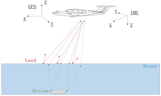
The ALT provides very detailed terrain information, but its lasers cannot penetrate the water surface itself. Considering the features of coastal areas, and with the development of airborne LiDAR technology, it was able to integrate more advanced sensors for collecting more accurate and informative point clouds from different wavelengths, such as Optech CZMIL and Riegl VQ-880G for measuring shoreline characteristics [24][61][71][24,57,58]. The ALB commonly employs two laser rangefinders with different wavelengths, near-infrared (NIR) and green [78][59], as shown in Table 3. The measuring principle of the ALB is the NIR beam, which can measure the land and water surface [78][59], and the green beam can penetrate the water [79][60] and is reflected back from the seabed or lakebed, as shown in Figure 1. The measuring depth can vary over a range of 25–70 m, depending on the different systems [61][57]. ALB is becoming a fundamental tool for coastal scientists within coastal studies, due to its bathymetric ability to distinguish topographic (high density) and bathymetric (low density) LiDAR points, providing the elevation data that are critical to producing datum-based shoreline, and that are suitable for measuring the features in coastal areas [13][25][13,25].
Another example is the Scotland LiDAR project, which was conducted for five phases (still ongoing). Phase I was initialed by the Scottish Government, Scottish Environmental Protection Agency (SEPA), and Scottish Water, collaboratively. Phase 3 was initially captured by Fugro for the Scottish Power Energy Network (www.spatialdata.gov.scot (accessed on 8 December 2022)). The collaboration between the cross-functional organizations to collect the dataset may occur because the cost of collecting airborne LiDAR data is relatively high. Similarly, well-developed countries such as the USA, where LiDAR data have fully covered the coastal area nationwide, have more open airborne LiDAR-based data of the coastal area. Therefore, even though airborne LiDAR has demonstrated the ability and advantage in shoreline mapping tasks, data availability is still a challenge.
Table 3.
A summary of airborne laser bathymetric scanning system (ALB) used in shoreline related studies.
Figure 1.
| New Zealand | |||||
| Airborne LiDAR point clouds | |||||
| 1 m | 2010–present | More than half coastal line | Still ongoing to collect the data | https://www.linz.govt.nz/products-services/data/types-linz-data/elevation-data/provincial-growth-fund-LiDAR-data-collection-now-progress | (accessed on 8 December 2022) |