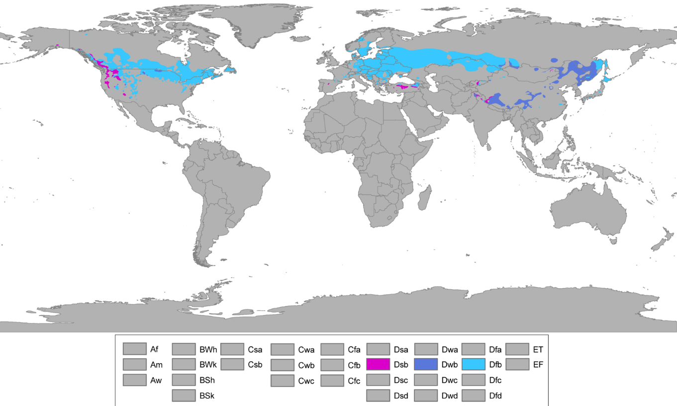
A humid continental climate is a climatic region defined by Russo-German climatologist Wladimir Köppen in 1900, typified by four distinct seasons and large seasonal temperature differences, with warm to hot (and often humid) summers and cold (sometimes severely cold in the northern areas) winters. Precipitation is usually distributed throughout the year. The definition of this climate regarding temperature is as follows: the mean temperature of the coldest month must be below −3 °C (26.6 °F) and there must be at least four months whose mean temperatures are at or above 10 °C (50 °F). In addition, the location in question must not be semi-arid or arid. The Dfb, Dwb and Dsb subtypes are also known as hemiboreal. Humid continental climates are generally found roughly between latitudes 40° N and 60° N, within the central and northeastern portions of North America, Europe, and Asia. They are much less commonly found in the Southern Hemisphere due to the larger ocean area at that latitude and the consequent greater maritime moderation. In the Northern Hemisphere some of the humid continental climates, typically in Hokkaido, Northern Honshu, Sakhalin island, Scandinavia, Nova Scotia, and Newfoundland are heavily maritime-influenced, with relatively cool summers and winters being just below the freezing mark. More extreme humid continental climates found in northeast China , southern Siberia, the Canadian Prairies, and the Great Lakes region of the American Midwest and Central Canada combine hotter summer maxima and colder winters than the marine-based variety.
- hemiboreal
- seasonal temperature
- continental climate
1. Definition
Using the Köppen climate classification, a climate is classified as humid continental when the temperature of the coldest month is below −3 °C [26.6 °F] and there must be at least four months whose mean temperatures are at or above 10 °C (50 °F).[1] These temperatures were not arbitrary. In Europe, the −3 °C (27 °F) average temperature isotherm (line of equal temperature) was near the southern extent of winter snowpack. The 10 °C (50 °F) average temperature was found to be the minimum temperature necessary for tree growth.[2] Wide temperature ranges are common within this climate zone.[3]
Second letter in the classification symbol defines seasonal rainfall as follows: [1]
- s: A dry summer—the driest month in the high-sun half of the year (April to September in the Northern Hemisphere, October to March in the Southern Hemisphere) has less than 30 millimetres (1.18 in)/40 millimetres (1.57 in) of rainfall and has exactly or less than 1⁄3 the precipitation of the wettest month in the low-sun half of the year (October to March in the Northern Hemisphere, April to September in the Southern Hemisphere),
- w: A dry winter—the driest month in the low-sun half of the year has exactly or less than one‑tenth of the precipitation found in the wettest month in the summer half of the year,
- f: Without dry season—does not meet either of the alternative specifications.
while the third letter denotes the extent of summer heat:[1]
- a: Hot summer, warmest month averages at least 22 °C (71.6 °F),
- b: Warm summer, warmest month averages below 22 °C (71.6 °F) and at least four months averages above 10 °C (50.0 °F).
1.2. Associated Precipitation
Within North America, moisture within this climate regime is supplied by the Great Lakes, Gulf of Mexico and adjacent western subtropical Atlantic.[4] Precipitation is relatively well distributed year-round in many areas with this climate (f), while others may see a marked reduction in wintry precipitation,[2] which increases the chances of a wintertime drought (w).[5] Snowfall occurs in all areas with a humid continental climate and in many such places is more common than rain during the height of winter. In places with sufficient wintertime precipitation, the snow cover is often deep. Most summer rainfall occurs during thunderstorms,[2] and in North America and Asia an occasionally tropical system. Though humidity levels are often high in locations with humid continental climates, the "humid" designation means that the climate is not dry enough to be classified as semi-arid or arid.
1.3. Vegetation
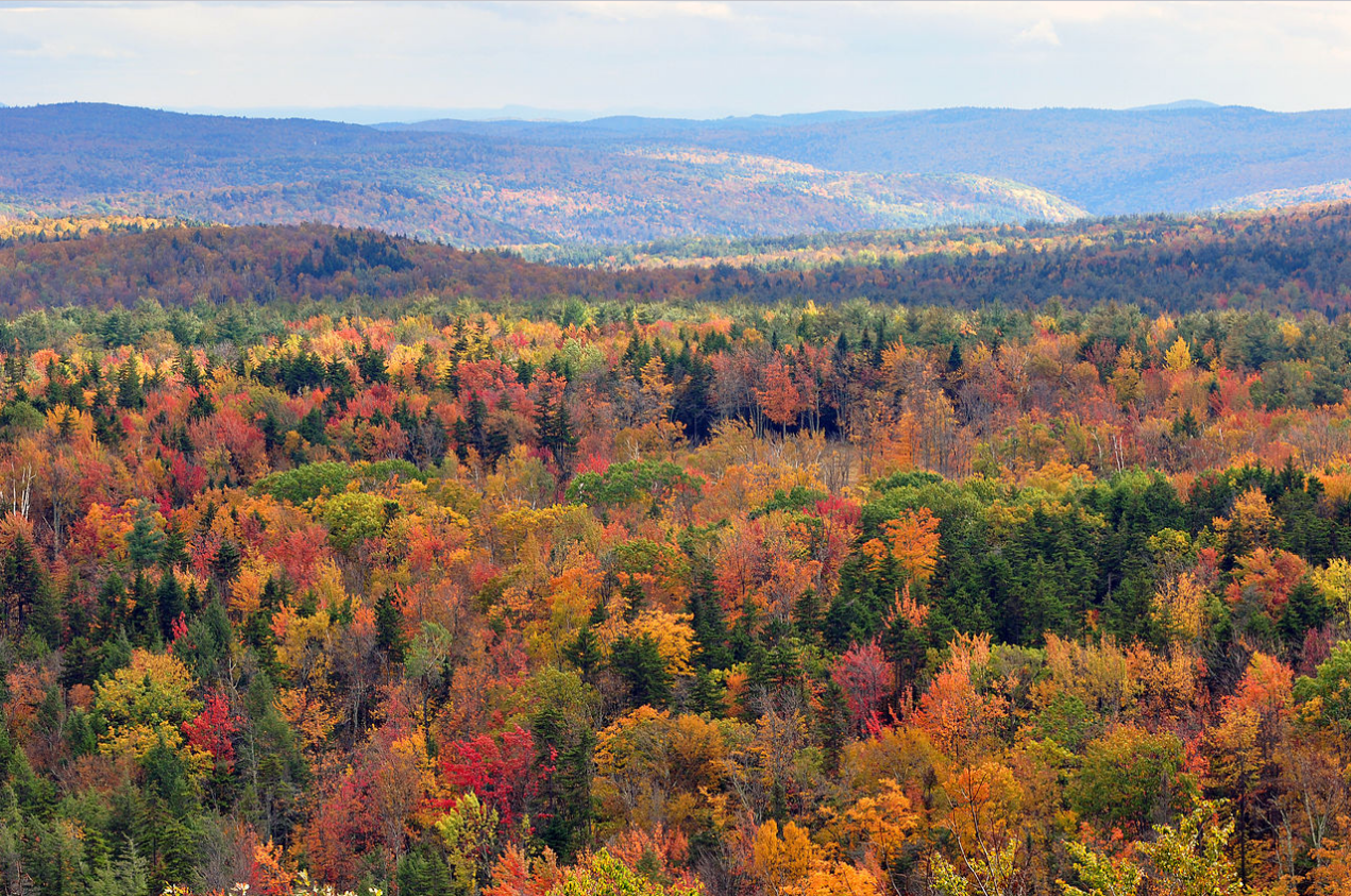
By definition, forests thrive within this climate. Biomes within this climate regime include temperate woodlands, temperate grasslands, temperate deciduous, temperate evergreen forests,[4] and coniferous forests.[6] Within wetter areas, maple, spruce, pine, fir, and oak can be found. Fall foliage is noted during the autumn.[2]
2. Hot Summer Subtype

A hot summer version of a continental climate features an average temperature of at least 22 °C (71.6 °F) in its warmest month.[7] Since these regimes are limited to the Northern Hemisphere, the warmest month is usually July or August. High temperatures in the warmest month tend to be in the high 20s or low 30s °C (80s or low 90s °F), while average January afternoon temperatures are near or well below freezing. Frost free periods normally last 4–7 months within this climate regime.[2]
Within the United States , this climate includes small areas from the lower Midwest eastward to the lower Great Lakes, parts of the western United States. In Canada it consist of Southern Ontario and Greater Montreal. Precipitation increases further eastward in this zone and is less seasonally uniform in the west. The western states of the central United States (namely Montana, Wyoming, parts of southern Idaho, most of Lincoln County in Eastern Washington, parts of Colorado, parts of Utah, western Nebraska, and parts of western North and South Dakota) have thermal regimes which fit the Dfa climate type, but are quite dry, and are generally grouped with the steppe (BSk) climates.
In the Eastern Hemisphere, this climate regime is found within interior Eurasia, east-central Asia, and parts of India . Within Europe, the Dfa climate type is present near the Black Sea in southern Ukraine , the Southern Federal District of Russia , southern Moldova, Serbia, parts of southern Romania, and Bulgaria,[8][9] but tends to be drier and can be even semi-arid in these places. In East Asia, this climate exhibits a monsoonal tendency with much higher precipitation in summer than in winter, and due the effects of the strong Siberian High much colder winter temperatures than similar latitudes around the world, however with lower snowfall, the exception being western Japan with its heavy snowfall. Tōhoku, between Tokyo and Hokkaidō and Western coast of Japan also has a climate with Köppen classification Dfa, but is wetter even than that part of North America with this climate type. A variant which has dry winters and hence relatively lower snowfall with monsoonal type summer rainfall is to be found in northern China including Manchuria and parts of North China, and over much of the Korean Peninsula; it has the Köppen classification Dwa. Much of central Asia, northwestern China, and southern Mongolia have a thermal regime similar to that of the Dfa climate type, but these regions receive so little precipitation that they are more often classified as steppes (BSk) or deserts (BWk).
Dsa climates are rare; they are generally restricted to elevated areas adjacent to Mediterranean climate regions with a Csa climate well inland to ensure hot summers and cold winters.
This climate zone does not exist at all in the southern hemisphere, where the only landmass that enters the upper-middle latitudes, South America, tapers too much to have any place that gets the combination of snowy winters and hot summers. Marine influences preclude Dfa, Dwa, and Dsa climates in the southern hemisphere.
3. Warm Summer Subtype
Also known as Hemiboreal climate, areas featuring this subtype of the continental climate have an average temperature in the warmest month below 22 °C (72 °F). Summer high temperatures in this zone typically average between 21–28 °C (70–82 °F) during the daytime and the average temperatures in the coldest month are generally far below the −3 °C (27 °F) (or 0 °C (32.0 °F)) isotherm. Frost-free periods typically last 3–5 months. Heat spells lasting over a week are rare. Winters are long, cold, and severe.[2]
The warm summer version of the humid continental climate covers a much larger area than the hot subtype. In North America, the climate zone covers from about 42°N to 50°N latitude mostly east of the 100th meridian, including most of southern Canada , The Maritimes, and Newfoundland, as well as the northern United States from the eastern North Dakota east to Massachusetts . However, it can be found as far north as 54°N, and further west in the Canadian Prairie Provinces and below 40°N in the high Appalachians. In Europe this subtype reaches its most northerly latitude at nearly 61° N.
High-altitude locations as South Lake Tahoe, California, and Aspen, Colorado, in the western United States exhibit local Dfb climates. The south-central and southwestern Prairie Provinces also fits the Dfb criteria from a thermal profile, but because of semi-arid precipitation portions of it are grouped into the BSk category.
In Europe, it is found in much of Eastern Europe and southern parts of Scandinavia not bathed by the Atlantic Ocean or North Sea: Ukraine (the whole country except the Black Sea coast), Belarus , Poland (one third of the east), Russia , Sweden (historical region of Svealand), Finland (south end, including the three largest cities),[9] Norway (most populated area),[1] Estonia, Latvia, Lithuania, Slovakia, Romania (generally above 100 m) and Hungary (generally above 100 m).[8] It has little warming or precipitation effects from the northern Atlantic.[9] The cool summer subtype is marked by mild summers, long cold winters and less precipitation than the hot summer subtype; however, short periods of extreme heat are not uncommon. Northern Japan has a similar climate.
In the Southern Hemisphere it exists in well-defined areas only in the Southern Alps of New Zealand, in the Snowy Mountains of Australia in Kiandra, New South Wales (only dashes)[10] and the Andes Mountains of Argentina and Chile .[11]
4. Use in Climate Modeling
Since climate regimes tend to be dominated by vegetation of one region with relatively homogenous ecology, those that project climate change remap their results in the form of climate regimes as an alternative way to explain expected changes.[12]
References
- Peel, M. C.; Finlayson B. L.; McMahon, T. A. (2007). "Updated world map of the Köppen−Geiger climate classification". Hydrol. Earth Syst. Sci. 11 (5): 1633–1644. doi:10.5194/hess-11-1633-2007. ISSN 1027-5606. Bibcode: 2007HESS...11.1633P. http://www.hydrol-earth-syst-sci.net/11/1633/2007/hess-11-1633-2007.pdf.
- C. Donald Ahrens; Robert Henson (2015). Meteorology Today (11 ed.). Cengage Learning. pp. 491–492. ISBN 978-1305480629. https://books.google.com/books?id=5Dx-BAAAQBAJ&pg=PT516.
- Steven Ackerman; John Knox (2006). Meteorology: Understanding the Atmosphere. Cengage Learning. p. 419. ISBN 978-1-305-14730-0. https://books.google.com/books?id=_ceVBAAAQBAJ&pg=PA413.
- Andy D. Ward; Stanley W. Trimble (2003). Environmental Hydrology, Second Edition. CRC Press. pp. 30–34. ISBN 978-1-56670-616-2. https://books.google.com/books?id=yANwmTjf588C&pg=PA30.
- Vijendra K. Boken; Arthur P. Cracknell; Ronald L. Heathcote (2005). Monitoring and Predicting Agricultural Drought : A Global Study: A Global Study. Oxford University Press. p. 349. ISBN 978-0-19-803678-4. https://books.google.com/books?id=y6r9jUTzJiYC&pg=PA349.
- Timothy Champion; Clive Gamble; Stephen Shennan; Alisdair Whittle (2009). Prehistoric Europe. Left Coast Press. p. 14. ISBN 978-1-59874-463-7. https://books.google.com/books?id=bMMMlPReRm4C&pg=PA14.
- Gordon B. Bonan (2008). "6. Earth's Climate". Ecological Climatology: Concepts and Applications. Cambridge University Press. ISBN 978-1-107-26886-9. https://books.google.com/books?id=VMdxa1idt1YC.
- Joseph Hobbs (2012). Fundamentals of World Regional Geography. Cengage Learning. p. 76. ISBN 978-1-285-40221-5. https://books.google.com/books?id=IfMKAAAAQBAJ&pg=PA76.
- Michael Kramme (2012). Exploring Europe, Grades 5 - 8. Carson-Dellosa Publishing. p. 12. ISBN 978-1-58037-670-9. https://books.google.com/books?id=28VpAgAAQBAJ&pg=PA43.
- Crosbie, R. S.; Pollock, D. W.; Mpelasoka, F. S.; Barron, O. V.; Charles, S. P.; Donn, M. J. (2012-09-18). "Changes in Köppen-Geiger climate types under a future climate for Australia: hydrological implications". Hydrology and Earth System Sciences (Copernicus GmbH) 16 (9): 3341–3349. doi:10.5194/hess-16-3341-2012. ISSN 1607-7938. Bibcode: 2012HESS...16.3341C. https://dx.doi.org/10.5194%2Fhess-16-3341-2012
- "Updated Köppen-Geiger climate map of the world". https://people.eng.unimelb.edu.au/mpeel/koppen.html.
- Michal Belda; Eva Holtanová; Tomáš Halenka; Jaroslava Kalvová (2014-02-04). "Climate classification revisited: from Köppen to Trewartha". Climate Research 59 (1): 1–14. doi:10.3354/cr01204. Bibcode: 2014ClRes..59....1B. https://www.int-res.com/articles/cr_oa/c059p001.pdf.