Bluetooth Low Energy (BLE) is a positioning technology that is commonly used in indoor positioning systems (IPS) such as shopping malls or underground parking lots, because of its low power consumption and the low cost of Bluetooth devices. It also maintains high positioning accuracy. However, it is necessary to configure a large number of devices in the environment to obtain accurate positioning results. A planar model that conforms to the signal strength in the environment was generated, wherein the database comparison method is replaced by an equation solution, to improve various costs but diminish the positioning accuracy. WeResearchers propose to further replace the planar model with a cost-effective fitting model to both save costs and improve positioning accuracy
- indoor positioning
- RSS
- BLE
- fitting model
1. Introduction
2. Related Works
Whether it is Wi-Fi, BLE, RFID, or others, distance measurement and positioning are achieved through the path loss characteristics of radio waves; that is, signal strength gradually decreases with increased distance. However, in indoor environments, signals are easily affected by multipath propagation, making IPS research challenging. Nowadays, there are many studies related to positioning measurement methods, which can be divided into three categories, namely time-based methods, angle-based methods, and received signal strength-based methods. These three methods were explained in [4][3]. The popular received signal strength-based methods and other positioning systems are explained below.2.1. Received Signal Strength-Based Methods
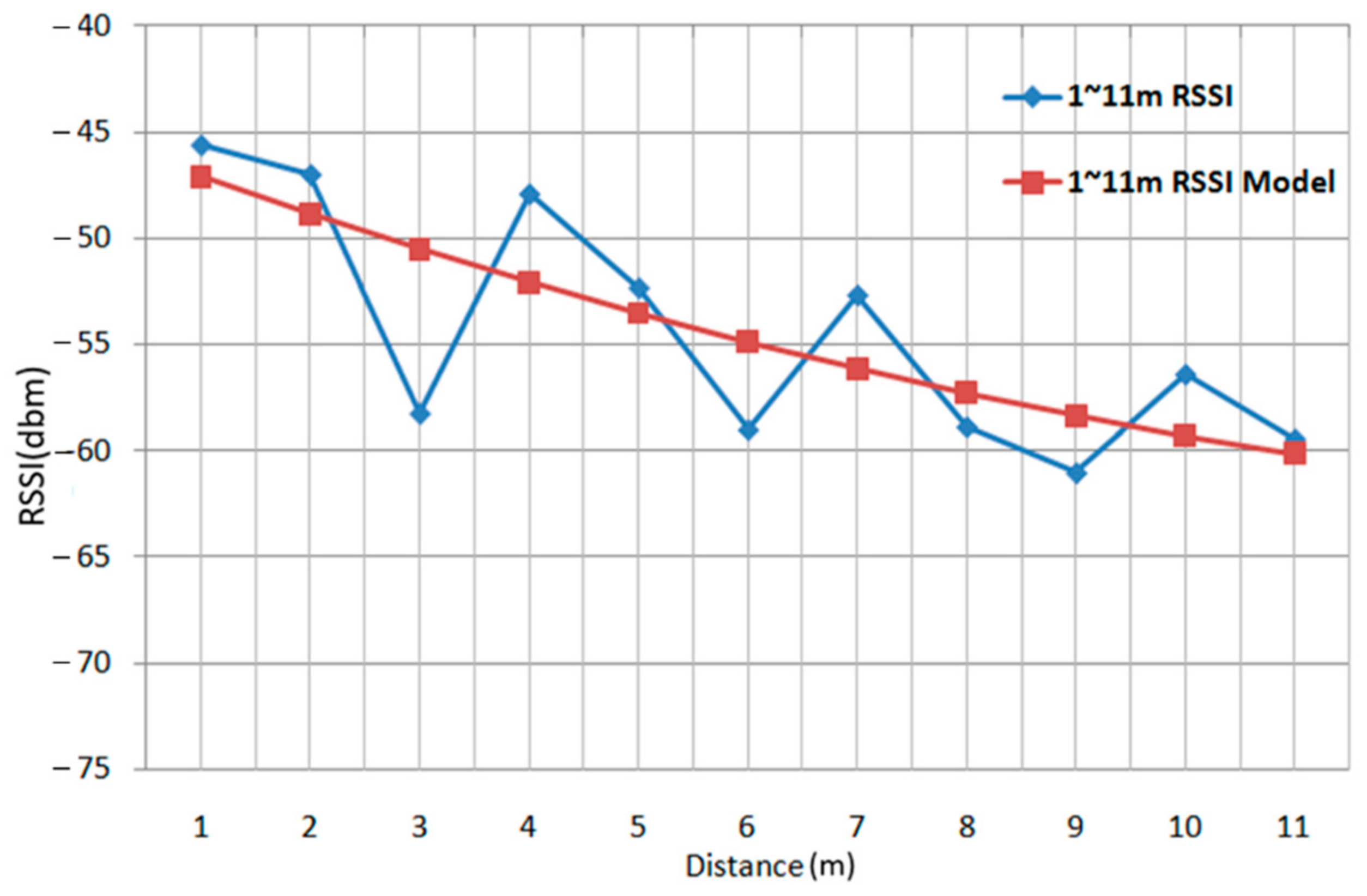
Most of the positioning technology developed using received signal strength (RSS) technology is based on the attenuation value of signal strength between the transmitter and the receiver to measure the distance. The prediction model [2] for calculating distance based on signal transmission is shown in Formula (1). P(d) is the signal strength value of the user’s location; d is the distance from the wireless BS; P(d0) is the signal strength of the reference point; d0 is the distance between the reference point and the wireless BS; n is parameter related to the signal strength attenuation due to the distance; nW is the number of walls; C is the maximum allowable number of walls; WAF is the wall attenuation factor; WAF will vary depending on the wall material. This model was proposed as RADAR by Microsoft in order to reduce the cost of the offline stage in IPS. It requires considerable time and manpower to collect the signal strength characteristics of each reference point, and these costs will be proportional to the size of the environment. Microsoft uses radio signals from indoor Wi-Fi wireless base stations for IPS using RADAR positioning technology, as published by IEEE INFOCOM in 2000. The RADAR system is the RSS positioning method based on signal strength, which can be divided into two stages, namely the offline stage and the online stage [2]. In the offline stage, the RSSI of each reference point (i.e., access point, AP) is collected multiple times. Because the signal strength received for each reference point is different, the characteristics of the individual signal patterns can be obtained and sorted for the database. In the subsequent online stage, the signal strength received through the current location is compared with the signal pattern database created in the offline stage to derive the user’s position based on a comparison result from the signal pattern matching. Thus, this is called a signal pattern-matching method as shown in Figure 1. The RSSI received during the online stage is compared with the database created in the offline stage to obtain the user’s position. The Euclidean distance Formula (2) is used for calculation with the RSSI obtained online and all RSSIs in the database, where X is the RSSI of the user’s location; Y is the RSSI of the reference point in the database; n is the number of base stations; and d(x) is the comparison between the user and the database reference point after calculation. As a result, the number of reference points in the database is the number of d(x) solutions, and from all d(x), the reference point closest to the user can be calculated. The signal pattern-matching method is currently a common and highly accurate method for IPS. However, because the positioning method continuously compares the data in the database, the amount of calculation is complex. When the positioning environment is larger, more signal pattern data are required for comparison; thus, the calculation complexity also increases. Therefore, reducing the computational complexity has become a problem that needs to be considered to effectively improve the signal pattern-matching IPS, and the use of models to replace the comparison method has become an effective means to reduce the computational complexity. Numerous studies have explored the relationship between signal strength and the distance between wireless base stations and devices [5[4][5][6],6,7], and have found the relationship to be inversely proportional. However, the curve in the relationships fluctuates up and down without the rule of linearity. In order to reduce the computational complexity, an equation is used instead of signal pattern comparison; the linear model obtained from the equation is used to replace the signal strength curve, as shown in Figure 2.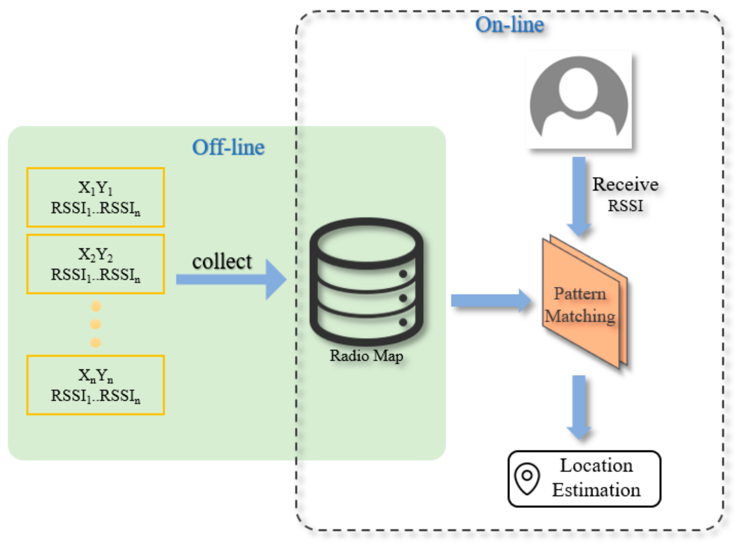
2.2. Other Positioning Systems
The ZigBee positioning system uses the triangulation method for positioning; it does not use signal transmission and reception time difference for distance conversion, rather it uses the signal and distance relationship model to convert the signal strength into distance. Equation (3) presents the ZigBee model based on the relationship between signal strength and distance [9]. where RSSI is the signal strength at the receiver; d is the distance between the receiver and the transmitter; d0 is the distance in measurement units; n is the signal attenuation value; and A is the signal strength per unit distance. Using this model, the relationship between ZigBee signal strength and distance can be obtained, and triangulation can be used for positioning. However, because there are many obstacles in most rooms, shadowing effects, or signal diffraction and reflection easily occur. The resulting multipath effect leads to error between the calculated transmission distance and the actual distance, so the calculated position is relatively inaccurate. Radio frequency identification (RFID) positioning technology detects a tag through the RFID reader, and knows the range of the RFID reader where the tag is located. However, the range of RFID is quite limited. The ultra-high frequency (UHF) RFID tag can only reach a transmission distance of 5 m. This equipment is mostly used to determine whether an object is present at or passes through a preset position; it is impossible to detect exactly where the object is. RFID is not suitable for indoor positioning due to its small transmission range. The iBeacon [10], a BLE device officially launched by Apple, is based on Bluetooth-based positioning technology. Compared with other technologies such as Wi-Fi, due to its small size, low power consumption and low cost, it is more suitable for applications in various commercial environments and indoor venues. Nowadays, most Bluetooth positioning technologies use multiple iBeacons installed inside as base stations to transmit signal strength, that is, RSS. Similar to Wi-Fi, different transmission distances will have different degrees of attenuation. After receiving the signal strength, the receiving port can calculate the distance between the receiving port and each iBeacon, and then apply a triangulation method to obtain the location of a mobile phone in the area. However, the positioning accuracy and stability of BLE is still affected by human body shadowing and multipath interference. Studies in [11,12,13,14,15][11][12][13][14][15] are related to Bluetooth indoor positioning technology in recent years. The study in [11] added the Bluetooth signal strength to the weighting, and used a signal pattern comparison method for positioning. Ref. [12] used iBeacon combined with polynomial regression model (PRM), fingerprinting (FP) and extended Kalman filter technology for indoor positioning. Using FP and PRM to estimate the position of the target and the distance between the target and iBeacon, respectively, algorithm achieved an accuracy of less than 2.56 m when the beacons were densely deployed (one iBeacon per nine meters). Ref. [13] combined Wi-Fi and BLE technologies with radio fingerprinting to allow users to create radio maps and update them continuously. Ref. [14] used signal-to-noise ratio (SNR) and Bluetooth signal strength to perform positioning calculations through a machine learning service provided by Amazon Web Services (AWS). Ref. [15] proposed a particle filter-based indoor positioning system to localize tags that can broadcast BLE beacon messages. To reduce fluctuations of RSSI data, they design a Kalman filter to smooth those data. Based on the smoothed RSSI data, they propose a particle filter to conduct IPS tasks. Though the above methods are all aimed at improving positioning accuracy, they also increase the burden of computational complexity. Comparisons of characteristics in various positioning technologies are summarized in Table 1. Table 1.| Wireless Position System | Localization Technique | Range | Accuracy |
|---|---|---|---|
| DOLPHIN (RF with Ultrasonic) | ToA, trilateration | Indoor | 2 cm |
| RFID/INS | RSS/INS | Indoor | 2 m |
| UWB | TDoA/ToA, trilateration | 15 m | 10 cm |
| RFID/FPM | RSS/INS | Indoor | 1.7 m |
| Land Marc | RSS, triangulation | 50 m | 1~2 m |
| GPS | ToA, trilateration | Global | 1~5 m |
| Radar | RSS, triangulation | Indoor | Indoor |
| Cricket | ToA, trilateration | 10 m | 2 cm |
| Active Bats | ToA, trilateration | 50 m | 9 cm |
| Active Badge | ToA, trilateration | 5 m | 7 cm |
| COMPASS | RSS, triangulation | 15 m | 1.65 m |
| WhereNet (RF) | RSS, triangulation | 20 m | 2~3 m |
| LiFS | Fingerprinting database | Indoor | 9 m |
| Bluetooth | RSSI fingerprinting/RSSI theoretical propagation model | Indoor | 2~5 m |
References
- Parkinson, B.W.; Enge, P.; Axelrad, P.; Spilker, J.J., Jr. Global Positioning System: Theory and Applications; American Institute of Aeronautics and Astronautics: Reston, VA, USA, 1996; Volume II.
- Bahl, P.; Padmanabhan, V.N. RADAR: An in-Building RF-Based User Location and Tracking System. In Proceedings of the IEEE INFOCOM 2000, Conference on Computer Communications, Nineteenth Annual Joint Conference of the IEEE Computer and Communications Societies (Cat. No.00CH37064), Tel Aviv, Israel, 26–30 March 2000; Volume 2, pp. 775–784.
- Zhang, D.; Xia, F.; Yang, Z.; Yao, L.; Zhao, W. Localization Technologies for Indoor Human Tracking. In Proceedings of the 2010 International Conference on Future Information Technology, Busan, Korea, 20–24 May 2010; pp. 1–6.
- Yeh, S.C.; Chiou, Y.S.; Peng, Y.J. A Research for Indoor LBS Technology Based on RSSI Prediction Model. J. Inform. Electron. 2006, 1, 1–8.
- Wang, C.L.; Chiou, Y.S.; Yeh, S.C. A Location Algorithm Based on Radio Propagation Modeling for Indoor Wireless Local Area Networks. In Proceedings of the 2005 IEEE Vehicular Technology Conference, Stockholm, Sweden, 30 May–1 June 2005; Volume 5, pp. 2830–2834.
- Chen, Y.; Kobayashi, H. Signal Strength Based Indoor Geolocation. In Proceedings of the 2002 IEEE International Conference on Communications, New York, NY, USA, 28 April–2 May 2002; pp. 436–439.
- Chen, Y.-S.; Hsu, C.-S.; Chung, R.S. A Semi-Supervised 3D Indoor Localization Using Multi-Kernel Learning for WiFi Networks. Sensors 2022, 22, 776.
- Lu, T.-T.; Yeh, S.-C.; Wu, S.-H. Actualizing real-time indoor positioning systems using plane models. Int. J. Commun. Syst. 2015, 29, 874–892.
- Loganathan, A.; Ahmad, N.S.; Goh, P. Self-Adaptive Filtering Approach for Improved Indoor Localization of a Mobile Node with Zigbee-Based RSSI and Odometry. Sensors 2019, 19, 4748.
- iBeacon. Available online: http://www.ibeacon.com/ (accessed on 1 February 2020).
- Pu, Y.-C.; You, P.-C. Indoor positioning system based on BLE location fingerprinting with classification approach. Appl. Math. Model. 2018, 62, 654–663.
- Zhuang, Y.; Yang, J.; Li, Y.; Qi, L.; El-Sheimy, N. Smartphone-Based Indoor Localization with Bluetooth Low Energy Beacons. Sensors 2016, 16, 596.
- Kriz, P.; Maly, F.; Kozel, T. Improving Indoor Localization Using Bluetooth Low Energy Beacons. Mob. Inf. Syst. 2016, 2016, 2083094.
- Terán, M.; Carrillo, H.; Parra, C. WLAN-BLE Based Indoor Positioning System using Machine Learning Cloud Services. In Proceedings of the 2018 IEEE 2nd Colombian Conference on Robotics and Automation, Barranquilla, Colombia, 1–3 November 2018; pp. 1–6.
- Shen, Y.; Hwang, B.; Jeong, J.P. Particle filtering-based indoor positioning system for beacon tag tracking. IEEE Access 2020, 8, 226445–226460.
- Yeh, S.; Lai, C.; Tsai, F.; Chiou, Y. Research on calibration-free fingerprinting positioning techniques based on terrestrial magnetism databases for indoor environments. IET Radar Sonar Navig. 2022, 16, 896–911.