A morpho-functional classification of the humipedons could be defined as this: 1) Classification: = ordering things = summarizing the complexity of reality = putting nature in boxes, to "possess" nature, to "enumerate", divide, understand nature, get to know our home (oikos) = putting a name on things (just like names for people); 2) Type of classification: Momorpho-functional; not : researchers do not put objects in the boxes but "machines" has to be classified, "running s= systems", "natural that turn = clocks" full of interconnected cogwheels and that may indicate the time, system = machines that inform us about how they livesomething works; morpho stays forwhy? because researchers want to find visible forms that characterize eachthe "machine" and which cto communicate withbetween us: if there are those visible forms,forms then we are facingit is that type of "systemmachine"; 3) Some soil scientistsResearchers classify (morpho-functionally) only humipedons ( = not all the soil profiles), but only the organic (H and O) and organo-mineral (A) horizons of the soil profile. Because theyresearchers think these horizons are highly y are the ones most connected to the present day evolutionfunctioning of the ecosystems. The other parts of the soil are very important too, but they don't work at the speed that interests present day evolutionus most, tens of years, to be more precise, from one to 100 years.
- humipedon
- humus system
- humus form
- humusica
- carbon cycle
- soil classification
- global change
- soil biodiversity
1. Introduction: A Humipedon Classification Is Needed
2. The Environment in Which the Targeted Humipedon Is Found
Soil organisms and biota activities evolve with the environment and generate horizons and subunits in tune with it. Once the vertical structure of the soil is unveiled and the humipedon is circumscribed, it is necessary to establish in which main “ecological frame” the observed topsoil is located. On a large scale, five sets of humipedons can be identified:-
Terrestrial: humipedons that never submerged for more than a few days per year; peaty and water-filled horizons absent. These humipedons belong to Mull or non-Mull systems (Moder, Mor, Amphi, and Tangel);
-
Histic Semiterrestrial: submerged humipedons characterized by peaty horizons; presence of a water table (perched or not). These humipedons belong to Fibrimoor, Mesimoor, Amphimoor, Saprimoor, and Anmoor systems;
-
Aqueous Semiterrestrial: humipedons by the sea in tidal area, or submerged;
-
Para systems: humipedons connected to the other three groups (Para = next to) in a dynamic way; they either precede the others in time or develop with them (overlapped, juxtaposed). These are Archaeo (extremophile microorganisms), Anaero (submerged organotrophic microorganisms), Crusto (cyanobacteria, lichens, algae, fungi), Rhizo (roots, rhizoids), Bryo (mosses), and Ligno (decaying wood agents) systems.
-
Anthropic systems: Agro (natural humipedons anthropogenically transformed for agricultural purposes) and Techno (manmade imitation of natural humipedons, e.g., compost, or without a specific purpose (waste dumps, etc.)).
3. TerrHum: Humusica in Your Phones and Tablets
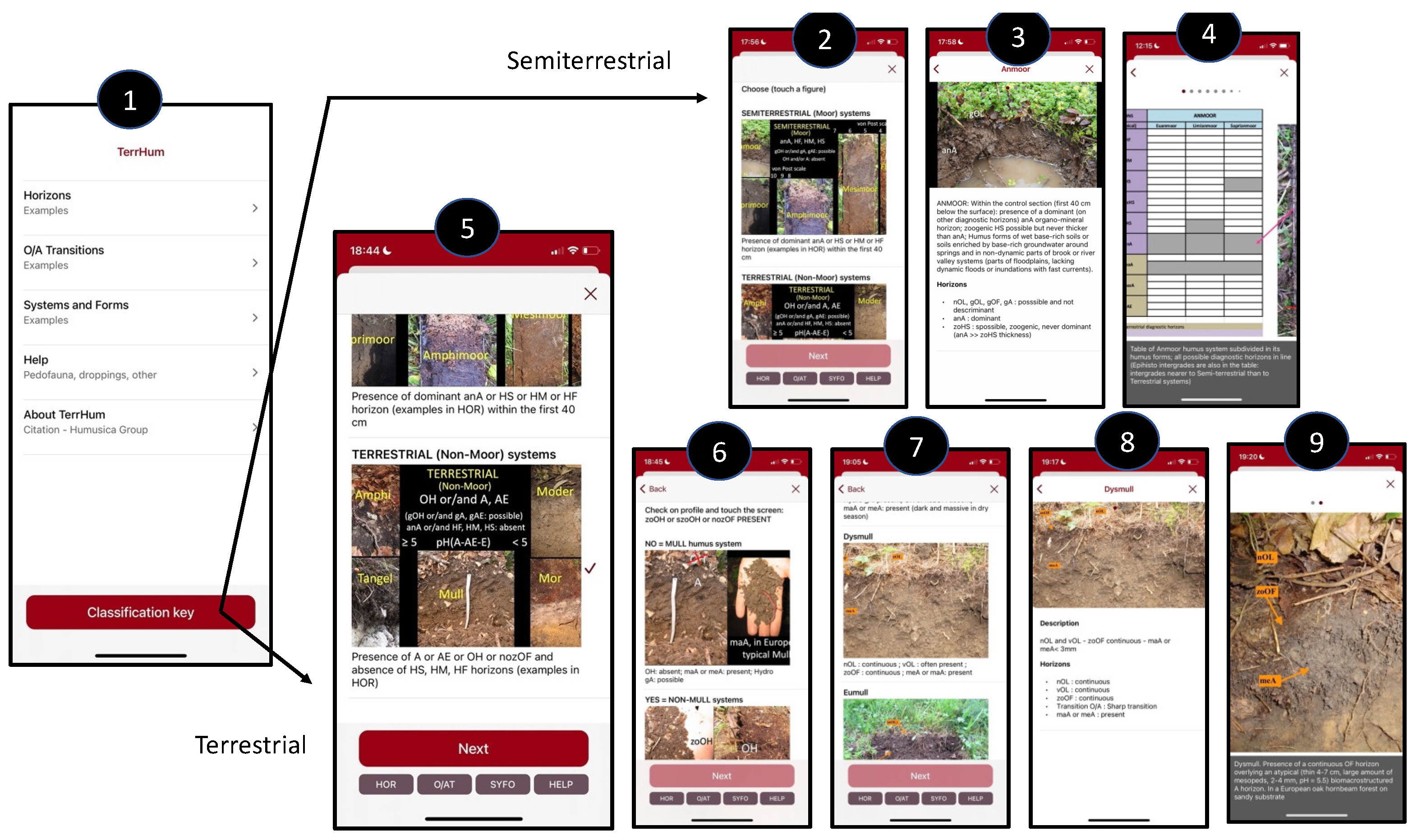
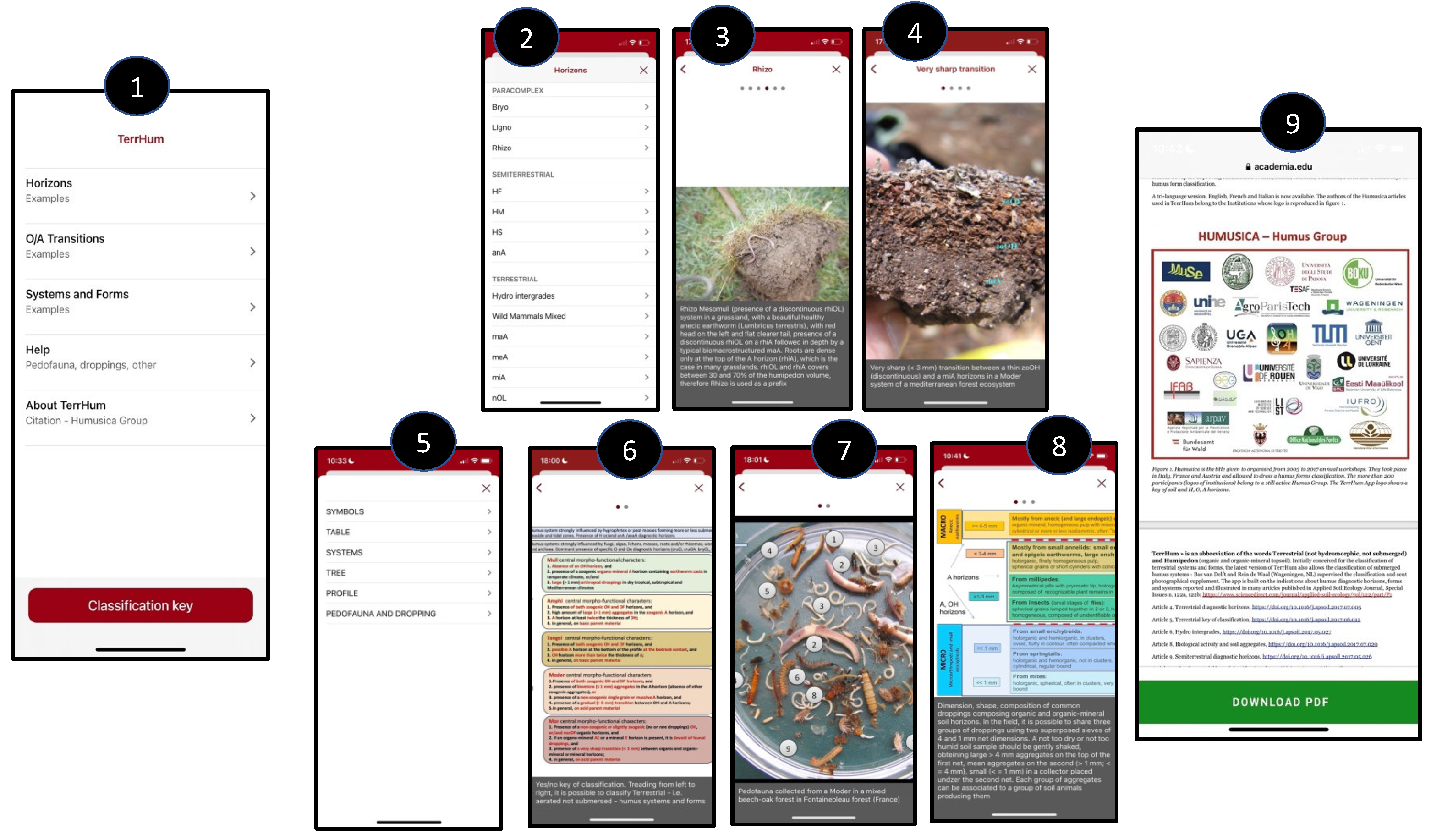
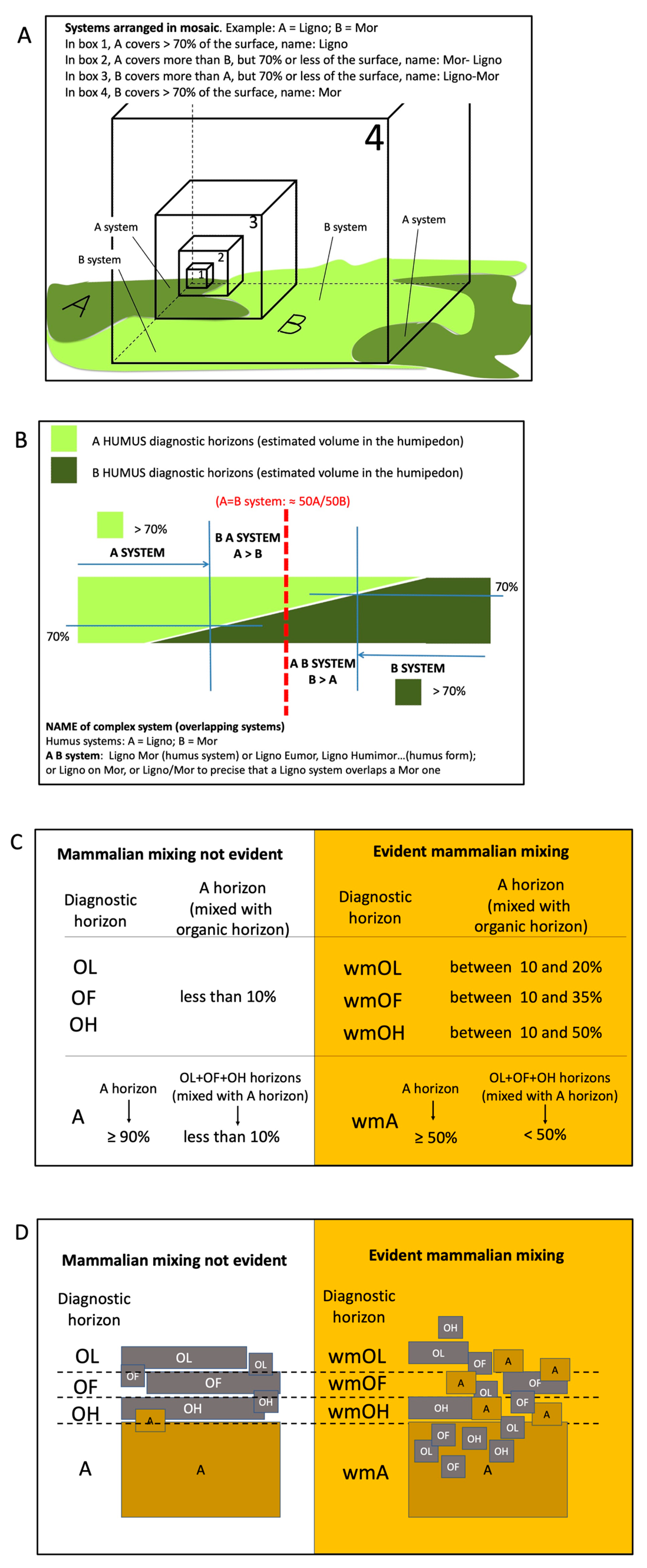
The TerrHum name assembles the abbreviated words Terra (planet Earth in Italian) and Humipedon (organic and organomineral humus horizons). With this application, a user can classify the Terrestrial and Histic semiterrestrial humipedons of our planet. It also contains some information on the diagnostic horizons of Para systems, such as the Bryo, Rhizo and Ligno, and on horizons disrupted by wild mammals. The application is built on the indications on the diagnostic horizons reported and illustrated in articles 4, 5, 6, 9, 10, 11, and 13. The App is freely available on the iOS (App Store) and Android (Google Play) platforms in English, French, and Italian. TerrHum makes use of many figures that are stored in a cloud and downloaded on cellphones the first time the users recall them. Once all figures (about 140) have been opened, devices do not need to be connected to run the application. Instead of describing the App, researchers show some figures that illustrate how it works (Figure 1, Figure 2 and Figure 3).


References
- Certini, G.; Scalenghe, R.; Amundson, R. A view of extraterrestrial soils. Eur. J. Soil Sci. 2009, 60, 1078–1092.
- Zanella, A.; Ponge, J.-F.; Gobat, J.-M.; Juilleret, J.; Blouin, M.; Aubert, M.; Chertov, O.; Rubio, J.L. Humusica 1, article 1: Essential bases–Vocabulary. Appl. Soil Ecol. 2018, 122, 10–21.
- Ponge, J.F. Humus: Dark side of life or intractable ‘aether’? Pedosphere 2022, 32, 660–664.
- Paul, E.A. The nature and dynamics of soil organic matter: Plant inputs, microbial transformations, and organic matter stabilization. Soil Biol. Biochem. 2016, 98, 109–126.
- Churchland, C.; Grayston, S.J. Specificity of plant-microbe interactions in the tree mycorrhizosphere biome and consequences for soil C cycling. Front. Microbiol. 2014, 5, 261.
- Tecon, R.; Or, D. Biophysical processes supporting the diversity of microbial life in soil. FEMS Microbiol. Rev. 2017, 41, 599–623.
- Dwivedi, D.; Riley, W.; Torn, M.; Spycher, N.; Maggi, F.; Tang, J. Mineral properties, microbes, transport, and plant-input profiles control vertical distribution and age of soil carbon stocks. Soil Biol. Biochem. 2017, 107, 244–259.
- Rumpel, C.; Kögel-Knabner, I. Deep soil organic matter—A key but poorly understood component of terrestrial C cycle. Plant Soil 2011, 338, 143–158.
- Pombubpa, N.; Pietrasiak, N.; De Ley, P.; Stajich, J.E. Insights into dryland biocrust microbiome: Geography, soil depth and crust type affect biocrust microbial communities and networks in Mojave Desert, USA. FEMS Microbiol. Ecol. 2020, 96, fiaa125.
- Hao, J.; Chai, Y.N.; Lopes, L.D.; Ordóñez, R.A.; Wright, E.E.; Archontoulis, S.; Schachtman, D.P. The Effects of Soil Depth on the Structure of Microbial Communities in Agricultural Soils in Iowa (United States). Appl. Environ. Microbiol. 2021, 87, e02673-20.
- Frey, R.W. Concepts in the Study of Biogenic Sedimentary Structures. J. Sediment. Res. 1973, 43, 6–19.
- Freppaz, M.; Pintaldi, E.; Magnani, A.; Viglietti, D.; Williams, M.W. Topsoil and snow: A continuum system. Appl. Soil Ecol. 2018, 123, 435–440.
- Berg, B.; McClaugherty, C. Plant Litter; Springer International Publishing: Cham, Switzerland, 2020.
- Korkina, I.; Vorobeichik, E. Humus Index as an indicator of the topsoil response to the impacts of industrial pollution. Appl. Soil Ecol. 2018, 123, 455–463.
- Kukuļs, I.; Nikodemus, O.; Kasparinskis, R.; Žīgure, Z. Humus forms, carbon stock and properties of soil organic matter in forests formed on dry mineral soils in Latvia. Est. J. Earth Sci. 2020, 69, 63.
- Büks, F.; van Schaik, N.L.; Kaupenjohann, M. What do we know about how the terrestrial multicellular soil fauna reacts to microplastic? Soil 2020, 6, 245–267.
- Bani, A.; Pioli, S.; Ventura, M.; Panzacchi, P.; Borruso, L.; Tognetti, R.; Tonon, G.; Brusetti, L. The role of microbial community in the decomposition of leaf litter and deadwood. Appl. Soil Ecol. 2018, 126, 75–84.
- Zanella, A.; Ponge, J.-F.; Matteodo, M. Humusica 1, article 7: Terrestrial humus systems and forms—Field practice and sampling problems. Appl. Soil Ecol. 2018, 122, 92–102.
- Lovelock, J.E.; Margulis, L. Atmospheric homeostasis by and for the biosphere: The gaia hypothesis. Tellus 1974, 26, 2–10.
- Barlow, J.; França, F.; Gardner, T.A.; Hicks, C.; Lennox, G.D.; Berenguer, E.; Castello, L.; Economo, E.P.; Ferreira, J.; Guénard, B.; et al. The future of hyperdiverse tropical ecosystems. Nature 2018, 559, 517–526.
- Ripple, W.J.; Wolf, C.; Newsome, T.M.; Barnard, P.; Moomaw, W.R. World scientists’ warning of a climate emergency. Bioscience 2019, 70, 8–12.
- Ali, A.; Chen, H.Y.; You, W.-H.; Yan, E.-R. Multiple abiotic and biotic drivers of aboveground biomass shift with forest stratum. For. Ecol. Manag. 2019, 436, 1–10.
- Frazão, J.; Goede, R.; Brussaard, L.; Faber, J.H.; Groot, J.; Pulleman, M.M. Earthworm communities in arable fields and restored field margins, as related to management practices and surrounding landscape diversity. Agric. Ecosyst. Environ. 2017, 248, 1–8.
- Ponge, J.-F. Biodiversité et biomasse de la faune du sol sous climat tempéré. Comptes Rendus De L’académie D’agriculture De Fr. 2000, 86, 129–135.
- Blakemore, R.J. Critical Decline of Earthworms from Organic Origins under Intensive, Humic SOM-Depleting Agriculture. Soil Syst. 2018, 2, 33.
- Fournier, B.; Samaritani, E.; Frey, B.; Seppey, C.V.; Lara, E.; Heger, T.; Mitchell, E.A. Higher spatial than seasonal variation in floodplain soil eukaryotic microbial communities. Soil Biol. Biochem. 2020, 147, 107842.
- European Commission. The Factory of Life: Why Soil Biodiversity Is so Important; Office for Official Publications of the European Union: Luxembourg, 2010; Available online: https://ec.europa.eu/environment/archives/soil/pdf/soil_biodiversity_brochure_en.pdf (accessed on 27 June 2022).
- Joergensen, R.G.; Wichern, F. Alive and kicking: Why dormant soil microorganisms matter. Soil Biol. Biochem. 2018, 116, 419–430.
- Eisenhauer, N.; Antunes, P.M.; Bennett, A.E.; Birkhofer, K.; Bissett, A.; Bowker, M.A.; Caruso, T.; Chen, B.; Coleman, D.C.; de Boer, W.; et al. Priorities for research in soil ecology. Pedobiologia 2017, 63, 1–7.
- Zanella, A.; Ponge, J.-F.; Jabiol, B.; Sartori, G.; Kolb, E.; Gobat, J.-M.; Le Bayon, R.-C.; Aubert, M.; De Waal, R.; Van Delft, B.; et al. Humusica 1, article 4: Terrestrial humus systems and forms—Specific terms and diagnostic horizons. Appl. Soil Ecol. 2018, 122, 56–74.
- Zanella, A.; De Waal, R.; Van Delft, B.; Ponge, J.-F.; Jabiol, B.; De Nobili, M.; Ferronato, C.; Gobat, J.-M.; Vacca, A. Humusica 2, Article 9: Histic humus systems and forms—Specific terms, diagnostic horizons and overview. Appl. Soil Ecol. 2018, 122, 148–153.
- Damptey, F.G.; Birkhofer, K.; Nsiah, P.K.; De La Riva, E.G. Soil Properties and Biomass Attributes in a Former Gravel Mine Area after Two Decades of Forest Restoration. Land 2020, 9, 209.
- Keke, H.; Bo, Z. Leaching is the dominant route for soil organic carbon lateral transport under crop straw addition on sloping croplands. Plant Soil Environ. 2018, 64, 344–351.
- Moroni, M.T.; Hagemann, U.; Beilman, D.W. Dead Wood is Buried and Preserved in a Labrador Boreal Forest. Ecosystems 2010, 13, 452–458.
- Sofo, A.; Ricciuti, P.; Fausto, C.; Mininni, A.N.; Crecchio, C.; Scagliola, M.; Malerba, A.D.; Xiloyannis, C.; Dichio, B. The metabolic and genetic diversity of soil bacterial communities depends on the soil management system and C/N dynamics: The case of sustainable and conventional olive groves. Appl. Soil Ecol. 2019, 137, 21–28.
- Yang, Z.; Wullschleger, S.D.; Liang, L.; Graham, D.E.; Gu, B. Effects of warming on the degradation and production of low-molecular-weight labile organic carbon in an Arctic tundra soil. Soil Biol. Biochem. 2016, 95, 202–211.
- Chen, S.; Wang, W.; Xu, W.; Wang, Y.; Wan, H.; Chen, D.; Tang, Z.; Tang, X.; Zhou, G.; Xie, Z.; et al. Plant diversity enhances productivity and soil carbon storage. Proc. Natl. Acad. Sci. USA 2018, 115, 4027–4032.
- Batjes, N.H.; Batjes, N.H. Technologically achievable soil organic carbon sequestration in world croplands and grasslands. Land Degrad. Dev. 2019, 30, 25–32.
- Ping, C.L.; Jastrow, J.D.; Jorgenson, M.T.; Michaelson, G.J.; Shur, Y.L. Permafrost soils and carbon cycling. Soil 2015, 1, 147–171.
- Chiti, T.; Gardin, L.; Perugini, L.; Quaratino, R.; Vaccari, F.P.; Miglietta, F.; Valentini, R. Soil organic carbon stock assessment for the different cropland land uses in Italy. Biol. Fertil. Soils 2012, 48, 9–17.
- Zhao, Z.; Dong, S.; Jiang, X.; Zhao, J.; Liu, S.; Yang, M.; Han, Y.; Sha, W. Are land use and short time climate change effective on soil carbon compositions and their relationships with soil properties in alpine grassland ecosystems on Qinghai-Tibetan Plateau? Sci. Total Environ. 2018, 625, 539–546.
- Bojko, O.; Kabala, C. Organic carbon pools in mountain soils—Sources of variability and predicted changes in relation to climate and land use changes. Catena 2017, 149, 209–220.
- Zanella, A.; Katzensteiner, K.; Ponge, J.; Jabiol, B.; Sartori, G.; Kolb, E.; Le Bayon, R.; Aubert, M.; Ascher-Jenull, J.; Englisch, M.; et al. TerrHum: An iOS Application for Classifying Terrestrial Humipedons and Some Considerations about Soil Classification. Soil Sci. Soc. Am. J. 2019, 83, S42–S48.
- Zanella, A.; Ponge, J.-F.; Jabiol, B.; Sartori, G.; Kolb, E.; Le Bayon, C.; Gobat, J.-M.; Aubert, M.; De Waal, R.; Van Delft, B.; et al. Humusica 1, article 5: Terrestrial humus systems and forms—Keys of classification of humus systems and forms. Appl. Soil Ecol. 2018, 122, 75–86.
- Zanella, A.; Ponge, J.-F.; Briones, M.J. Humusica 1, article 8: Terrestrial humus systems and forms—Biological activity and soil aggregates, space-time dynamics. Appl. Soil Ecol. 2018, 122, 103–137.
