景观元素因其对热环境的直接影响而成为提高居民生活质量的重要手段,但景观元素的选择和表征在不同气候条件下对人体的热舒适度有不同的影响。本研究以西藏拉萨典型居民区为研究对象,采用正交试验方法制备实验方案,利用ENVILandscape elements have become an important means to improve the quality of life of residents because of their direct influence on the thermal environment, but the selection and configuration of landscape elements have different effects on human thermal comfort in different climate conditions. Therefore, in this study, in order to better understand the impact of residential landscape elements on the outdoor thermal environment and thermal comfort in a high-met进行模拟,探索高寒气候条件下绿色植被、水域、地面折射的侵入度,以及它们与冬夏热环境的相互作用。以生理当量温度(PET)为优化指标,确定了住宅景观元素协同效应的最优设计方案。结果如下。(altitude cold climate area, the typical residential area of Lhasa in Tibet was taken as the research object,the thermal environment of a residential area with different landscape element configurations was numerically simulated based on the orthogonal experimental design method. The PET was taken as the optimization objective, and the simulation results were analyzed with intuitive analysis and variance analysis. The main objectives were as follows:
(1)景观构象因子的顺序如下:绿色构象>水域面积>夏季叶面积指数>地面折射。在冬季,目>水域面积>地面反射率>叶面积指数(LAI)进行绿色构象。() To clarify the primary and secondary effects and advantages of various landscape elements on an outdoor thermal comfort under high altitude and cold climate conditions.
(2)通过正交试验和数值模拟的结合驱动,确定了景观构件的最优方案,即“灌木草坪,水域面积比16%,地面折射率为0) To clarify the synergistic relationship between landscape elements and their interaction with outdoor thermal comfort under high altitude and cold climate conditions.5,LAI
(3) To put forward the experimental scheme and strategy of landscape =element 3 m2/m3”。(3)最后,针对拉萨居民区典型户外活动空间提出了景观构象的最优设计策略。allocation optimization in a residential area for the conditions of high altitude and a cold climate.
- high altitude
- landscape elements
- outdoor thermal comfort
- orthogonal experiment
1. Background
1. The plane of the city of Lhasa is distribu
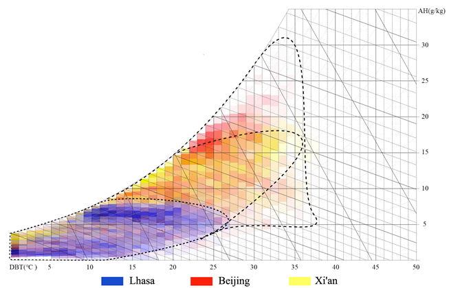
Lhasa is located in the middle of the Qinghai Tibet Plateau, with an altitude of 3650 meters. The plane of the city of Lhasa is distributed in a belt from east to west. Two mountains (South Mountain and North Mountain of Lhasa) sandwich the city, and a river (Lhasa River) passes through the city. It is a typical axial development city. According to the Chinese standard meteorological data, the hottest month is June, and the coldest month is January. The monthly average maximum temperature is above 20°C, the monthly average minimum temperature is below −3°C, and the annual temperature difference is 18.1°C . Lhasa belongs to the cold region in China's architectural climate zoning, but because it is located in the Qinghai Tibet Plateau, the climate conditions of Lhasa are significantly different from those of Beijing, Xi'an, Lanzhou (cold climate region), and other cities. By comparing the enthalpy and humidity diagrams of the three cities , it can be seen that the annual temperature and the humidity of Lhasa are relatively lower, and the annual temperature difference is also relatively smaller. Beijing and Xi'an also have coexisting heat and humidity, but Lhasa has a dry climate, so there is no such phenomenon.
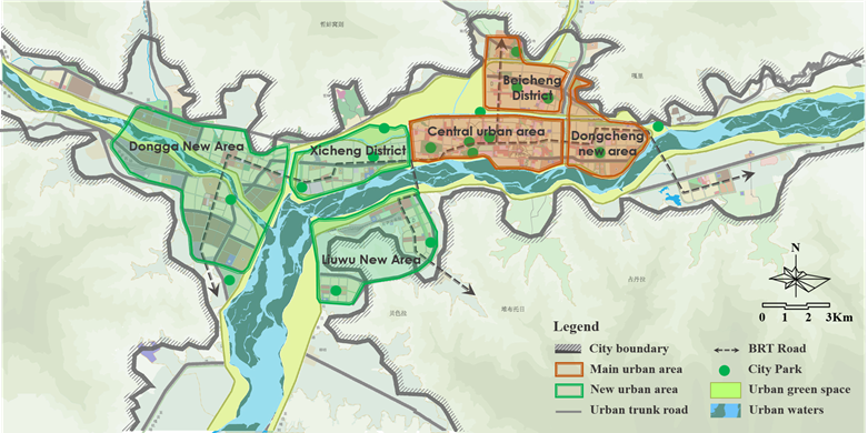
In this research, 60 residential areas were investigated and analyzed based on the following two factors . (1) Architectural layout: most of the architectural layout forms were the determinant at high south and low north as well as the mixed type of peripheral and determinant combination, and the number of building floors was mainly that for multilayer and small high-rise buildings. (2) The current situation of the landscape element allocations in residential areas, which is as follows: The common greening forms of green space are trees, shrubs, and grass. The types of underlying surfaces mainly include floor tiles, permeable bricks, gravel roads, grass planting bricks, permeable plastic, and lawns. The number of waterscape layout areas is small, the waterscape form is relatively single, and the shapes are mostly still water and fountains.
2. Literature Review
2.2. Characteristics of residents' behavior habits
The Lhasa area is affected by strong radiation, and the demand for shade space in summer is greater than that in winter. There is also a greater objective demand for the comfort of the outdoor space thermal environment in summer and winter (Figure 3). In this study, through a questionnaire survey, we examined the behavioral characteristics of outdoor activities of the local residents in Lhasa. The content of the questionnaire mainly included two parts: (1) basic information about respondents (gender, age, name, and ethnicity); and (2) respondents' behavior habits (activity time, activity form, and preferred activity venue).
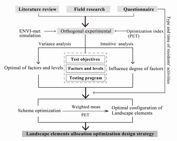
2.3. Research framework
因此,本研究为了更好地理解高海拔寒冷气候区住宅景观要素对室外热环境和热舒适性的影响,以拉萨为例,基于正交实验设计方法,对具有不同景观要素构象的居民区热环境进行了数值模拟。以PET为优化目标,采用直观分析和方差分析对仿真结果进行分析。主要目标如下:
(he research framework of this study is shown in this Figure : (1)阐明高海拔和寒冷气候条件下各种景观元素对室外热舒适性的主要和次要影响和优势。
() The landscape elements model of the residential area was grouped with the orthogonal design method to determine the experimental scheme. (2)阐明高海拔和寒冷气候条件下景观元素及其与室外热舒适相互作用的协同关系。
() ENVI-met, a three-dimensional urban microclimate simulation software jointly developed by Michael Bruse and Heriberfleet of Bochum University in Germany, was used for numerical simulation. This study used ENVI-met version v4.4.3 for the calculation to study the influence degree and the order of different landscape elements and their interaction with the thermal environment in residential areas. (3)提出高海拔、寒冷气候条件下居民区景观要素配置优化的试验方案和策略。
) The experiment optimization scheme with the collaborative action of landscape elements in a residential area was determined by taking the PET as the test index, and finally, the optimal design strategy was put forward.