1. International Governance Framework for the Sea
1.1. United Nations Convention for the Law of the Sea (UNCLOS)
The United Nations, in the context of its founding principles and in order to contribute to the preservation of peace and justice in all the countries, confirmed at the Geneva Conferences in 1958 and 1960 that there should be an acceptable convention for the law of the sea. The complete version of the United Nations Convention on the Law of the Sea (UNCLOS) was presented in 1982 in Montego Bay, Jamaica (
https://treaties.un.org/Pages/Treaties.aspx?id=21&subid=0&lang=en&clang=_en (accessed on 8 May 2022)), entered into force in 1994, and is today the world’s most recognized maritime law regime. The central idea of the UNCLOS convention is that maritime problems are interconnected and should be tackled as a whole. The provisions of the UN convention apply to all areas of marine affairs, including the organization and development of productive activities and the emergence of marine entrepreneurship.
1.2. Sea Zones in Accordance with UNCLOS Provisions
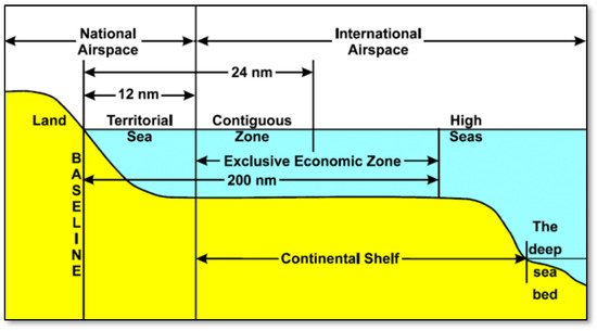
According to UNCLOS
[12][1] the following maritime zones can be distinguished (
Figure 2) in marine areas:
- Internal Waters include the sum of the stagnant or flowing surface water and groundwater located on the landward side relative to the territorial sea baseline. Inland waters are dominated by the coastal state and ships from other countries are not allowed to freely pass.
- Territorial Sea (or coastal zone) is the zone extending over a range of up to 12 nautical miles from the shoreline (baseline), involving the water column, bottom, subsoil, and airspace, within which states are free to impose any rule of law, regulate any use, and exploit any resource. In the territorial waters, the right of “innocent passage” of ships and aircraft is permitted (continuous, fast transit that does not disturb the peace and security of the coastal state).
- Contiguous Zone is the zone having an internal boundary outside the territorial waters and an external boundary of up to 24 nm from the baseline of territorial waters. In this border zone, the coastal state does not have complete authority, but has the necessary control to prevent specific infringements concerning its national legislation in the field of health, customs, migration, and economic matters.
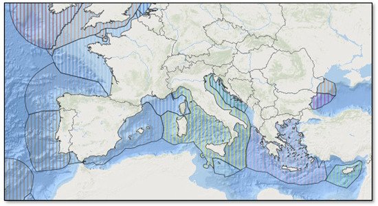
- Exclusive Economic Zone (EEZ) is the seabed and its subsoil extending beyond territorial waters to (potentially) a distance of 200 nm from the baseline (Figure 3). In the EEZ, the state does not exercise full sovereignty but sovereign rights. The EEZ regime covers all natural resources, whether living or not, as well as their economic exploitation, research, and environmental protection activities. In the case that the EEZs touch each other, it is up to the countries that are demanding them to jointly define maritime borders.
According to UNCLOS, an EEZ has only the inhabited islands, resulting from the presence of inhabitants, a lighthouse guardian, farm animals, cultivated land, and anything else that proves economic activity. However, for all other islands and rocks, the article of 12 nautical miles of the coastal zone is normally applied. A state’s rights in the EEZ are only created after a declaration of its sovereign rights to the UN. The EEZ regime explicitly permits the construction and use of artificial islands, installations and other structures, scientific research, and the protection and preservation of the marine environment. Within the EEZ of one state, all states have the right to navigate, flight, cable and pipe laying, and other uses in accordance with the international law of the sea.
- Continental Shelf is the seafloor and the subsurface extending beyond territorial waters up to (potentially) 200 nautical miles (and up to the outer boundary of the continental shelf if it extends over the 200 nm). In the continental shelf, the state does not exercise full authority but has the rights to extract and make use of the natural resources. Its meaning is weakened because it overlaps with that of the exclusive economic zone (EEZ).
- High Seas are located beyond the boundary of the continental shelf and where the premise of innocent passage, fishing, cable laying, and scientific research pipelines applies.
1.3. Delimitation of Maritime Zones
According to this article
[13][2], the UNCLOS mandated delimitation of marine zones is a driver of economic development, a management tool for the marine environment, and the foundation for spatial planning. Maritime regions and limits determine the borders of coastal nations, and their precise demarcation and cartographic portrayal is obligatory for every state. Even though the UN convention is a legislative document, its execution is purely technical, requiring scientific and practical knowledge of geoinformatics for those engaged.
1.4. The UNEP Regional Seas Programme
The concept of regional seas is used to identify and describe policies aimed at establishing and supporting multilateral, transnational cooperation networks in maritime clusters addressing common environmental issues. The ultimate goal is to create networks and partnerships between states to promote sustainability and identify the benefits of cooperative management of marine areas. The United Nations plays a central role in supporting such cooperation networks, and from the early 1970s has been trying to tackle integrated marine environmental problems through the Regional Seas Programme (RSP) (
https://www.unep.org/explore-topics/oceans-seas/what-we-do/regional-seas-programme (accessed on 8 May 2022)), currently developed for 13 marine areas. This program is being implemented in the context of the United Nations Environment Programme (UNEP) (
https://www.unep.org/ (accessed on 8 May 2022)), a central body for establishing the global agenda for the environment.
2. European Governance Framework for the Sea
2.1. Directive on the Conservation of Natural Habitats
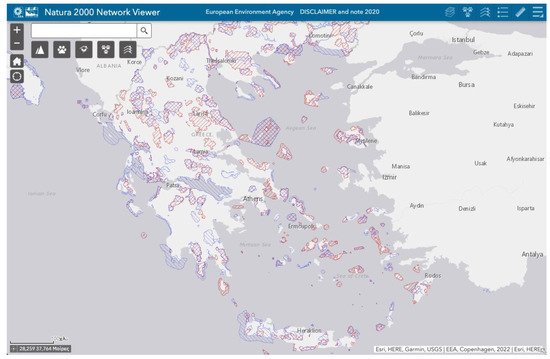
The EU Directive on the Conservation of Natural Habitats and of Wild Fauna and Flora (92/43/EEC) sets out the various procedures and commitments regarding the management of nature conservation in Natura 2000 sites, habitats, and species therein, including marine areas. For intance in Greece (Figure 4), the total marine area covers about 22% of national territorial waters.
2.2. Integrated Maritime Policy
The European Union (EU), recognizing the significant growth opportunity and dynamics of the seas, introduced the Integrated Maritime Policy (IMP), in order to organize and develop maritime cross-sections
[15][3]. Due to the maritime space having many peculiarities, including demarcation of knowledge and available data for geomorphology and environmental status, the pursuit of a new policy was a complex endeavor. The IMP was formally introduced in 2007, laying the foundations for a new European space development strategy, and to date, significant developments have been recorded. IMP defines MSP as a cross-sector policy instrument enabling public authorities and stakeholders to adopt a coordinated, integrated, and cross-border approach. The Marine Strategy Framework Directive (2008/56/EU) is the environmental pylon of the integrated policy that immediately followed and was incorporated in Greek law 3893/2011 (Government Gazette 144/A/17-6-2011).
2.2.1. Blue Growth Strategy
In 2012, EU introduced a long-term strategic planning focused towards long-term sustainability of the marine economic sectors. The strategy was introduced with the communication “Blue Growth: opportunities for marine and maritime sustainable growth”
[16][4], having as the main idea that the oceans are vital parameters for the development of the European economy, with comparative advantages in the fields of innovation and employment. Through the Blue Growth initiative, IMP could achieve the objectives set under the Europe 2020 strategy
[17][5] for smart, sustainable, and inclusive growth. The strategy consists of three components:
- (a)
-
Developing the marine sectors with the promise for long-term jobs creation and expansion.
-
- (b)
-
Providing knowledge, regulatory stability, and confidence in the ocean economy.
-
- (c)
-
Implementing sea basin policies to ensure states’ collaboration.
-
2.2.2. Data and Knowledge about the Sea
In August 2012, the green paper “Marine Knowledge 2020: from seabed mapping to ocean forecasting” was published
[18][6]. The Knowledge of the Sea 2020 Strategy, in addition to providing a comprehensive methodological framework and guidelines for marine data, aimed to make a real contribution to knowledge through the gathering of data from various sources. The ultimate goal was to facilitate the access of all interested public authorities and research organizations to marine data and to exploit the development of the Union’s maritime policy priorities for exploring new areas of activity.
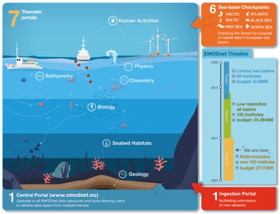
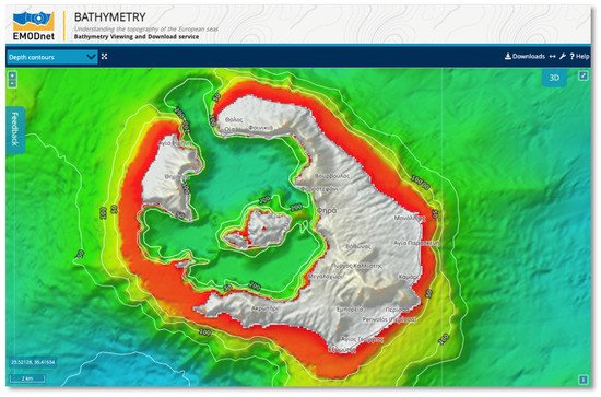
On this direction, the EU has undertaken the recording of marine data, at Union level, through the European Maritime Observation Network (EMODnet). This network is in its third phase of implementation by recording data across the marine area (surface, water column, bottom, and subsurface) with the participation of 150 research organizations (see
Figure 5). Through seven thematic websites (
Figure 6), EMODnet facilitates access to maritime data. As outlined in
[19][7], EMODnet’s goals are to:
-
Enhance efficiency in all operations that use marine data by minimizing data recollection and the expenses for gathering.
-
Boost competitiveness and creativity in existing and emerging maritime industries.
-
Decrease ambiguity in our understanding of the oceans and increase our ability to forecast.
2.3. Marine Spatial Planning Directive
In 2014, the EU adopted the Directive 2014/89/EU
[20][8] on the creation of a common framework for maritime planning in Europe. The Directive was incorporated as national law by the end of 2016, and all Member States should have maritime spatial planning studies in place by March 2021.
According to the preamble to Directive 2014/89/EU:
-
The rising interest for marine space for various marine activities, such as energy plants, oil and gas extraction, shipping, fishing, biodiversity conservation, tourism, and underwater cultural heritage, in conjunction with the numerous demands on coastal resources necessitate a holistic approach to planning and management of marine domain.
-
Adopting an ecosystem-based approach will aid in the long-term development and expansion of marine and coastal economies and the responsible use of coastal and marine resources.
-
To encourage the sustained coexisting of activities and, when applicable, the proper placement of complementary uses in the marine region, a framework is needed that typically includes the acceptance and execution by Member States of marine spatial planning outcomes in appropriate charts.
Environmental Impact Assessments
Special reference is made in the preamble of EU Directive 2014/89 to Directive 2001/42/EU, establishing the environmental impact assessment as a significant instrument for incorporating environmental concerns into project planning and programs approval, and it is noted that where maritime spatial plans:
-
Have a serious environmental impact, they are subject to Directive 2001/42/EU.
-
Incorporate Natura 2000 sites and to prevent overlap, the environmental impact assessment shall be supplemented with the criteria of Article 6 of Directive 1992/43/ EU.
The Mediterranean Action Plan
The Mediterranean coastal countries are included in the Mediterranean Action Plan (MAP), which is the first project implemented under the UN Regional Seas Program. In 1976, the Mediterranean Action Plan was ratified by fourteen Mediterranean countries and has since become institutionalized through the Barcelona Convention (
https://ec.europa.eu/environment/marine/international-cooperation/regional-sea-conventions/barcelona-convention/index_en.htm (accessed on 8 May 2022)). The Mediterranean Action Plan was amended in 1995 (MAPII) and the revised Barcelona Convention has been in force ever since. The headquarters of the Mediterranean Action Plan—Coordination Unit is in Athens, being responsible for the Barcelona Convention Secretariat, and develops general strategies, the latest being the Mid-Term Strategy (MTS) (
https://wedocs.unep.org/bitstream/handle/20.500.11822/6071/16ig22_28_22_01_eng.pdf (accessed on 8 May 2022)) 2016–2021. The goal of this strategy is “a healthy Mediterranean with marine and coastal ecosystems that are productive and biologically diverse contributing to sustainable development for the benefit of present and future generations”.