Driving is based on effective navigation. When using a navigation device, the user interface, the amount and quality of the underlying data and its representation all effect the quality of navigation. This study evaluates whether drivers in three different countries consider these devices to be useful and what functionality they would prefer. An online questionnaire was used to assess built-in navigation systems. The findings from 213 respondents show that current car GPSs are overloaded with features. Regardless of country, drivers simply require more basic functionality in the interface. It was also noted that the embedded functions in these devices are not fully utilized. In addition, many people use the navigation service to enter a new address while the car is moving. It may be worth examining how this option can be better implemented.
- car navigation
- built-in GPS
- GPS interface
1. Introduction
2. Brief History In-Car Navigation Devices
Specialized devices research specifically examines built-in GPS systems in cars. These types of navigation systems have been the subject of only a minimal amount of academic researchfor navigation assistance have been available for over a century. An advertisement dated 30 December 1909 describes a scrolling map associated with a steering wheel. By 1930, the Italian “Touring Club Italiano” worked on a simple principle: before starting, the driver selected and threaded the appropriate map sheets, and then the device rolled these sheets from one roll to another. The primary purpose of this research was to determine what should be implemented ioblem was that when the vehicle deviated from the route or came to a fork, the driver had to change the map sheet and find the current position a[2][3]. In new1966, generation of car navigation devices. We wanted to obtain answers to the following general questions:-
What do GPS systems look like today and how are they used?
-
Do drivers consider these devices to be appropriate? If not, what would they prefer?
-
Are there any differences in the preferences between countries with different economic backgrounds?
2. Our questionnaire
In viewBy of the guidelines for questionnaire design, we designed the survey to1985, the Etak Navigator, which used ‘dead reckoning’ to determine the vehicle’s position reach[2][6], was many people as possible in the threthe world’s first publicly available, in-car navigation system. GPS-based different countries. The same questions were asked in order to make the results comparable between countriesnavigation based on the US satellite configuration was introduced in 1990 in the Mazda Eunos Cosmo as part of the touch-screen car control system [7]. Two years later, the questions were translatworld’s first GPS with voice navigation was introduced in such a way to capture the identical meaning of each questionthe Toyota Celsior (Lexus LS—luxury sedan). In Europe, the BMW E38 incorporated GPS navigation in 1994 [8]). GooglIn the Forms was used because most people have familiarity with this online platform. Three separate “tiles” were created for the questionnaire. General US, it was introduced a year later by Oldsmobile, and called GuideStar. Selective availability was removed by the US government in 2000, making GPS signals more accurate, and GPS-based navigation of all forms became more prevalent. More and more car companies, businesses and tech giants have since entered the automotive GPS market.3. Evaluation of In-Car Navigation
A quvariestions were asked on the first sheet. Wty of studies have examined the effectiveness of in-car navigation. In 2009, TomTom users were asked about the presence or use of a built-in GPSuse of their navigation device [9]. iIn the last two questions. Those who answered “NO” to 2011, a Hungarian-founded company, NNG—which developed the iGO Navigation Engine—used a question about the usennaire to evaluate its system [10]. A Rofmanian study an in-carexamined traffic in reference to navigation systems w[11]. With the incre simply asked why they do not use it. The “YES” usage path consisted of 50 questions divided into three parts (see https://mercator.elte.hu/~vorosfanni/navigation.html).ased use of smartphones, free navigation applications have become popular. Hu et al., (2015) examined if drivers are willing to sacrifice some of the affordances of modern navigation systems in order to Aproltogether, 1557 replies were received from the three countriesong the phone’s battery life. The study also acquired data about the prevalence of phone-based GPSs and voice/visual preference [12]. ITo get was found that a large percentage of respinformation on prototypes of Google Maps Navigation during real-world usage, an Android-based feedback mechanism was developed [13]. Accordindents did not use ag to the 41 participants, most used the built-in car navigation system as a supplemental application [14].4. Spatial Knowledge Acquisition
3. Results
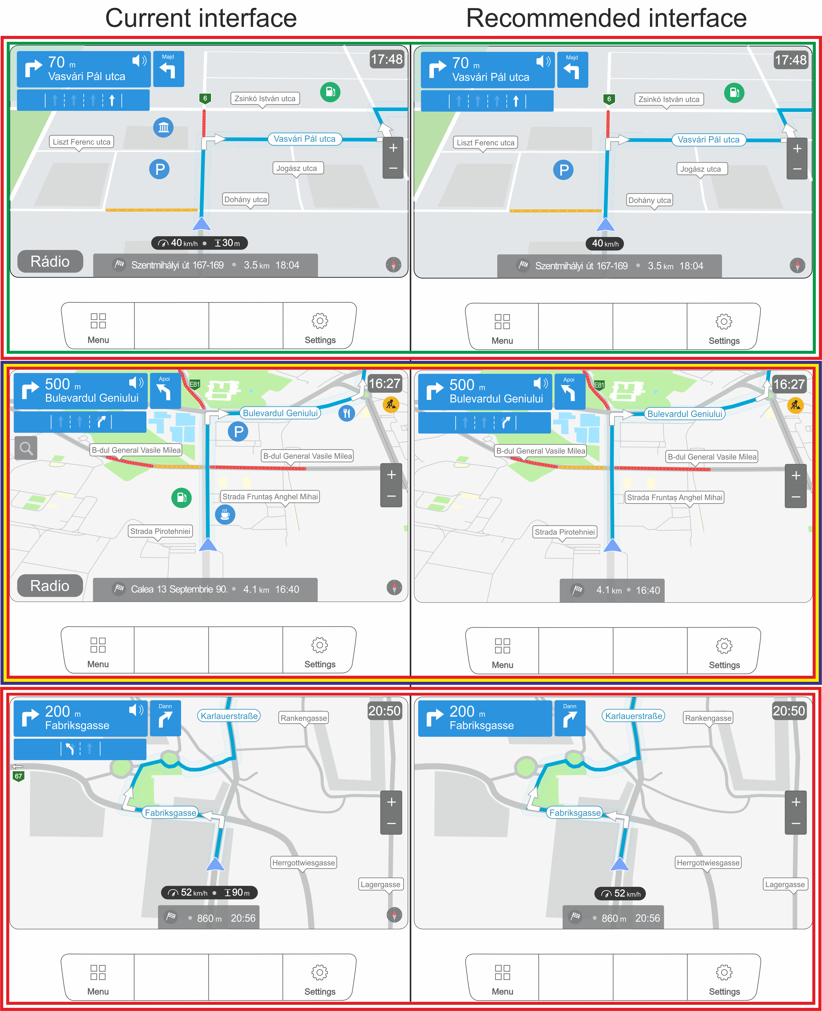
3.1. Current interfaces
ThDifferences last two optional questions of the questionnaire coin the spatial acquisition of knowledge between verbal instructions and mobile maps during driving were investigated in 2005 [15]. Münczerned what drivers see now on the built-in GPS “map” et al. compared three electronic navigation systems with paper maps [1]. It view and what they want to see. Similar answers were given to both questions. The responses were organas found that although navigation system users have poor survey knowledge, they have good route knowledge. It was also shown that the size of the map display has an effect on spatial knowledge acquisition [16]. ‘Wizeard into four groups: “I have it and I want it”,of Oz’ prototyping—a design methodology “I have it, but I don’t want it”, “I don’t have it but I want it” anused “I don’t have it and I don’t want it”.to Fimpror each country, two user interfaces were created from thesve user experience (UX)—was used in the research, e.g., no GPS was used. To compare spatial knowledge acquisition, Ishikawa et al. [17] included groups.3.2. Recommended interfaces
We used all four groups to create the proposed ideal interface, but we merged the values into two groups: I want it = “I have it and I want it” + “I don’t have it, but I want it” and I don’t want it = “I have it, but I don’t want it” + “I don’t have it and I don’t want it”.
 4. Discussion
We summarized the 213 answers of the three countries for all the 24 questions (4023 answers). The results are presented in Figure 11. Hungarian is used in the illustration. “Utca” means street and “Majd” means then. For other terms or help labels, the English meaning is shown in gray.
-
-
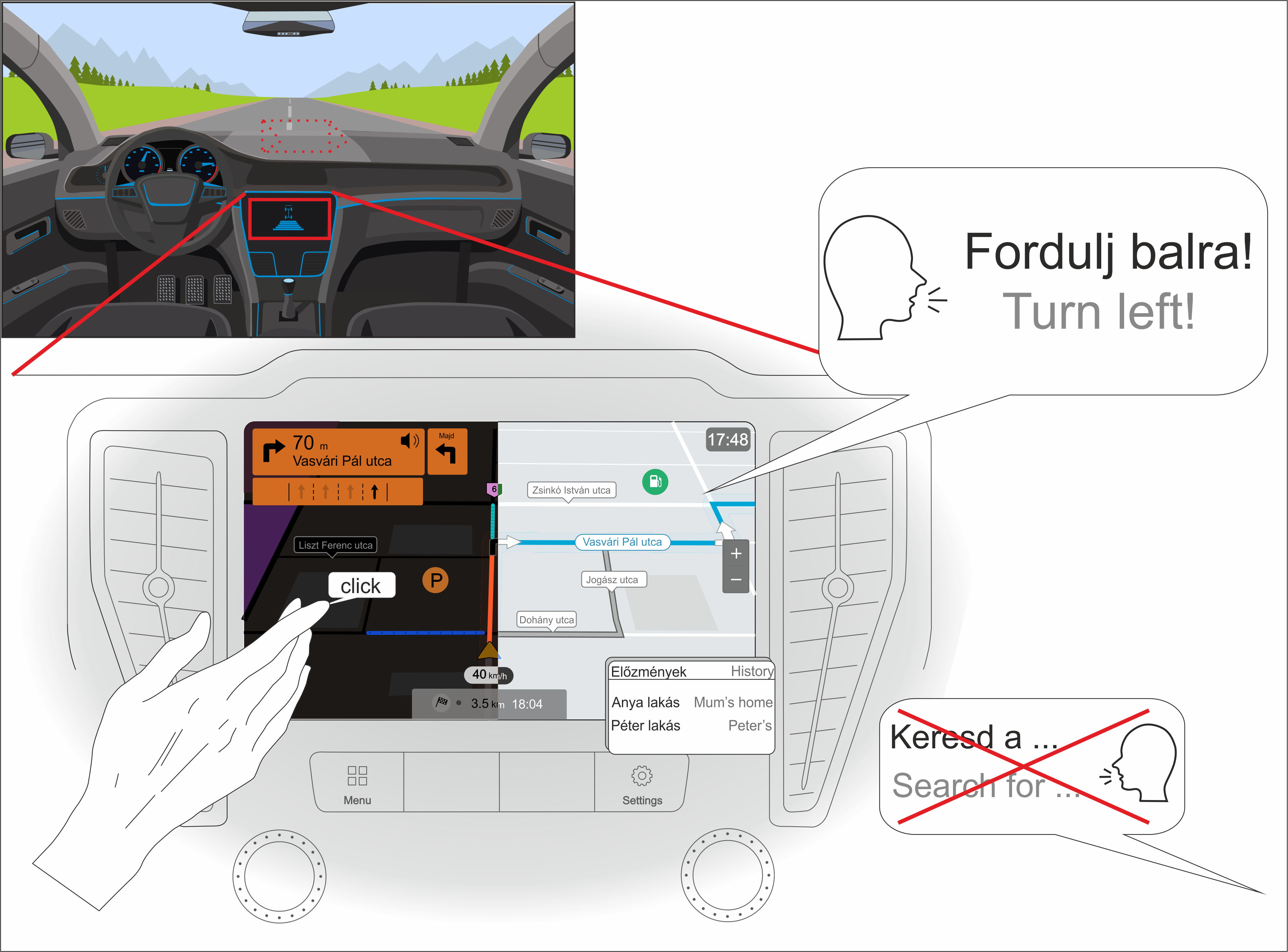
The device speaks the user’s native language most of the time but cannot handle voice commands—even if it implements voice recognition, it is more common that drivers do not take advantage of this feature.
-
Most people use a perspective view (with the facing direction to the north).
-
Although it was not specifically asked what input method was preferred (just what they currently have), we can conclude that: (A) many people are bothered by the navigation knob (it makes it difficult to enter text); and (B) voice navigation is not widely used. Based on these questions, the touchscreen has been designated as the required input.
-
Since only a small percentage of users (~30) indicated that they are specifically bothered by the click sound when they select something on the interface, we concluded that users will also want this sound to some extent.
-
Most would prefer the current placement of the navigation interface. The top of the center console also received a similar percentage, so we marked it with a dashed line.
-
Users prefer the night mode and they usually check the alternative routes during planning (gray line in the illustration).
-
Although it is not connected to the map view of the interface, most drivers use history for frequently visited addresses (mostly addresses of family or friends).
5. Conclusions
Inmap-based GPS general, it seems that car and navigation companies have likely navigation systems in their research (in addition to paper maps and direct travel experience).5. Location-Based Services
Lot carried out the necessary research to make built-in navigtion-based services (LBS) are mobile applications that give information devices really useful to a broadepending on the location and context of the user base[18][19]. Thise research can serve as a starting point. The specific findings are as follows:- (1)
-
Glargest and probably the most popular LBS applications (including driver assistance, passengerally speaking, the built-in GPSs currently on t information and vehicle management) are the mobile (car or pedestrian) navigation systems [20]. These market are overloaded with featuressystems are created and designed to help people during wayfinding activities in different environments [21]. Location-based Oinformation can the one hand,be conveyed to users themselves (regardless of country) seem to require less functionality in therough an overview map or as turn-by-turn instructions. According to Gartner [22], linmiterface, and on the other hand, the existing fund-sized screens provide a limited overview. This can be compensated with good wayfinding instructions [23]. Fabre not fullikant and Goldsberry ut[24] highlized either.
-
- (2)
-
Frghted that bottom-up a cartographic point of view,nd top-down mechanisms drive human visual attention. Unexperienced users desire theprocess animated display of fewer and fewer objectss based on perceptual salience and need them representeot thematic relevance [25]. Accord in thg to Ware [26], usimplest possible form. Furtrs can detect a maximum of four moving objects simultaneously. The ‘Geogr simplificaphic Information may be a necessary as a car navigation system is primarily intended to facilitate drivingDisplays’ (GID) offered by smartphones can be examined from (a) GIScience, (b) cartographic and (c) a cognitive science perspective [27].
- (3a)
-
The main downside challenge—from the GIScience perspective—is the price of these built-in devi‘context’ (information for a person, place or object characterization)—that is, adaptation, inference, management and modeling [28]. According to Griffin est al. Many[29], people’s also do not pay to update the data. Thus, these built-in devices will become less useful over timebehavior will change if they receive more information about the environment (e.g., spatial and task contexts often alter during navigation). Technical systems should solve this problem.
- (4b)
-
OInly a few users take advantage of t order to help the user’s understanding, graphic elements on the display should change according to many visual variables [30][31]. The more sophisticated the features in these devices. Those who do so do itvisualizations are, the better the performance of a navigation-related task. To this end, new functions have been developed, e.g., multi-scale traversal routes in a simultaneous representation, reducing the need to zoom in and out for orientation c[32]. The extent of a visualization task’s perfidentlyormance depends on expertise [33][34][35] and regularlymotional context [36].
- (5c)
-
GIDue to the different economic backgrounds in the counts should support the user’s mental representation of the variety of spatial conditions that can be used during navigation [27]. For navies surveyed, there are difgation, spatial information must be translated from one reference frame to another [37]. GIDs can facin the desired interfacelitate this transition by providing a track-up map that improves navigation efficiency [38]. With However, when looking at usagethe help of the GID’s instructions, the decision-making process of the user decreases [39][40], or rather distrabits, these differences become muccts the visual attention from the environment—the space is less experienced directly by the users [41][42].
6. User Experience
The more negligible.-
- (6)
-
Nterm “user experience” (UX) has av wigation software companiesde range of meanings [43]. shAccould notrding to Alben [44], ‘experience that a lot of people use the GPS while driving, especially to enter a new address. It may be worth re-thinking this feature to minimiz’ refers to the way interactive products are used: the sense of ownership, the feeling of use, how well the tools serve their purpose, whether they are understood to work and how well the tool fits into the environment in which it is used. The UX is (1) the potential for accidentsconsequence of the user’s internal state (expectations, needs, motivations, moods, etc.
-
-
-
-
-
-
References
- Münzer, S.; Zimmer, H.D.; Schwalm, M.; Baus, J.; Aslan, I. Computer-assisted navigation and the acquisition of route and survey knowledge. J. Environ. Psychol. 2006, 26, 300–308.
- Krausz, N.; Csepinszky, A.; Potó, V.; Barsi, Á. Az autós térképtől az önvezetésig: A járműnavigáció története. Geodézia Kartográfia 2019, 71, 14–18.
- Leite, J.P. A Brief History of GPS In-Car Navigation. Available online: https://ndrive.com/brief-history-gps-car-navigation/?fbclid=IwAR3Ddr2-kte_fkHCJhmEVp (accessed on 26 January 2022).
- Miller, T. 1966 In-Car Navigation System Looks Very Familiar Today. Available online: https://www.wheels.ca/news/1966-in-car-navigation-system-looks-very-familiar-today/ (accessed on 26 January 2022).
- Murph, D. Honda’s 1981 Electro Gyrocator: Vintage Navigation at Its Finest. Available online: https://www.engadget.com/2007-11-30-hondas-1981-electro-gyrocator-vintage-gps-at-its-finest.html?guce_referrer_us=aHR0cHM6Ly9lbi53aWtpcGVkaWEub3JnLw&guce_referre (accessed on 26 January 2022).
- Edwards, B. Who Needs GPS? The Forgotten Story of Etak’s Amazing 1985 Car Navigatigation System. Available online: https://www.fastcompany.com/3047828/who-needs-gps-the-forgotten-story-of-etaks-amazing-1985-car-navigation-system (accessed on 26 January 2022).
- Evans, S. 1993 Eunos/Mazda Cosmo Classic Drive. Available online: https://www.motortrend.com/reviews/12q2-1993-eunos-mazda-cosmo-drive/ (accessed on 26 January 2022).
- Gulde, D. 20 Jahre Navigation: Was Ist Aus Ihnen Geworden? Available online: https://www.auto-motor-und-sport.de/technik/20-jahre-navigation-was-ist-aus-ihnen-geworden/ (accessed on 26 January 2022).
- Al Mahmud, A.; Mubin, O.; Shahid, S. User experience with in-car GPS navigation systems. In Proceedings of the 11th International Conference on Human-Computer Interaction with Mobile Devices and Services, Bonn, Germany, 15–18 September 2009.
- Varga, G. Navigációs rendszerek használata: Felhasználói szokások és interakciók vizsgálata. BME Mob. Innovációs Központ 2011, 185. Available online: https://www.researchgate.net/publication/338374649_A_hazai_gepkocsivezetok_beepitett_GPS_hasznalati_szokasai_-javaslat_egy_uj_navigacios_felhasznaloi_feluletre (accessed on 20 February 2022).
- Mihai, P. Obiceiuri si atitudini in traficul din Romania. Rap. Cont. Futur. Motion 2018. Available online: https://www.promotor.ro/stiri-auto/obiceiuri-si-atitudini-in-traficul-din-romania-studiul-care-dezvaluie-ce-ii-deranjeaza-cel-mai-mult-pe-soferi-in-trafic-17789880 (accessed on 20 February 2022).
- Hu, S.; Choudhury, R.R.; Abdelzaher, T.F.; Su, L.; Li, S.; Wang, S.; Pan, C.; Gu, S.; Al Amin, M.T.; Liu, H.; et al. Experiences with eNav: A low-power vehicular navigation system. Exp. Enav. 2015, 433–444.
- Nakhimovsky, Y.; Miller, A.T.; Dimopoulos, T.; Siliski, M. Behind the scenes of google maps navigation. Assoc. Comput. Mach. 2010, 3763–3768.
- Wang, L.; Ju, D.Y. Concurrent use of an in-vehicle navigation system and a smartphone navigation application. Soc. Behav. Pers. 2015, 43, 1629–1640.
- Ortag, F. Sprachausgabe vs. Kartendarstellung in der Fußgängernavigation; Vienna University of Technology: Vienna, Austria, 2005.
- Gartner, G.; Hiller, W. Impact of restricted display size on spatial knowledge acquisition in the context of pedestrian navigation. Lect. Notes Geoinf. Cartogr. 2009, 155–166.
- Ishikawa, T.; Fujiwara, H.; Imai, O.; Okabe, A. Wayfinding with a GPS-based mobile navigation system: A comparison with maps and direct experience. J. Environ. Psychol. 2008, 28, 74–82.
- Raper, J.; Gartner, G.; Karimi, H.; Rizos, C. A critical evaluation of location based services and their potential. J. Locat. Based Serv. 2007, 1, 5–45.
- Brimicombe, A.; Chao, L. Location-Based Services and Geo-Information Engineering; John Wiley & Sons.: West Sussex, UK, 2009.
- Raper, J.; Gartner, G.; Karimi, H.; Rizos, C. Applications of location–based services: A selected review. J. Locat. Based Serv. 2007, 1, 89–111.
- Huang, H.; Gartner, G.; Krisp, J.M.; Raubal, M.; Van de Weghe, N. Location based services: Ongoing evolution and research agenda. J. Locat. Based Serv. 2018, 12, 63–93.
- Gartner, G. Location-based mobile pedestrian navigation services—The role of multimedia cartography. Methods 2003, B, 155–184.
- Giannopoulos, I.; Kiefer, P.; Raubal, M.; Richter, K.F.; Thrash, T. Wayfinding decision situations: A conceptual model and evaluation. Lect. Notes Comput. Sci. (Incl. Subser. Lect. Notes Artif. Intell. Lect. Notes Bioinform.) 2014, 8728, 221–234.
- Fabrikant, S.I.; Goldsberry, K. Thematic Relevance and Perceptual Salience of Dynamic Geovisualization Displays. In Proceedings of the 22th ICA/ACI International Cartographic Conference, A Coruña, Spain, 9–16 July 2005; Volume 1, pp. 11–16.
- Boucheix, J.M.; Lowe, R.K. An eye tracking comparison of external pointing cues and internal continuous cues in learning with complex animations. Learn. Instr. 2010, 20, 123–135.
- Ware, C. Information Visualisation: Perception for Design, 4th ed.; Kaufmann, M., Ed.; Elsevier: San Francisco, CA, USA, 2013; ISBN 978-0-12-812875-6.
- Thrash, T.; Fabrikant, S.I.; Brügger, A.; Do, C.T.; Huang, H.; Richter, K.F.; Lanini-Maggi, S.; Bertel, S.; Credé, S.; Gartner, G.; et al. The future of geographic information displays from giscience, cartographic, and cognitive science perspectives. In Proceedings of the 14th International Conference on Spatial Information Theory (COSIT 2019), Regensburg, Germany, 9–13 September 2019; Volume 142.
- Dey, A.K. Understanding and using context. Pers. Ubiquitous Comput. 2001, 5, 4–7.
- Griffin, A.L.; White, T.; Fish, C.; Tomio, B.; Huang, H.; Sluter, C.R.; Bravo, J.V.M.; Fabrikant, S.I.; Bleisch, S.; Yamada, M.; et al. Designing across map use contexts: A research agenda. Int. J. Cartogr. 2017, 3, 90–114.
- Bertin, J.; William, J.B.; Wainer, H. Semiology of graphics: Diagrams, Networks, Maps, Volume 1; University of Wisconsin Press: Madison, WI, USA, 1983.
- Roth, R.E. Visual Variables. Int. Encycl. Geogr. 2017, 1–11.
- Delikostidis, I.; Van Elzakker, C.P.J.M.; Kraak, M.J. Overcoming challenges in developing more usable pedestrian navigation systems. Cartogr. Geogr. Inf. Sci. 2016, 43, 189–207.
- Scaife, M.; Rogers, Y. External cognition: How do graphical representations work? Int. J. Hum. Comput. Stud. 1996, 45, 185–213.
- Hegarty, M.; Smallman, H.S.; Stull, A.T.; Canham, M.S. Naïve cartography: How intuitions about display configuration can hurt performance. Cartographica 2009, 44, 171–186.
- Maggi, S.; Fabrikant, S.I.; Imbert, J.P.; Hurter, C. How do display design and user characteristics matter in animations? An empirical study with air traffic control displays. Cartographica 2016, 51, 25–37.
- Gardony, A.; Brunyé, T.T.; Mahoney, C.R.; Taylor, H.A. Affective states influence spatial cue utilization during navigation. Presence Teleoperators Virtual Environ. 2011, 20, 223–240.
- Thorndyke, P.W.; Hayes-Roth, B. Differences in spatial knowledge acquired from maps and navigation. Cogn. Psychol. 1982, 14, 560–589.
- Münzer, S.; Zimmer, H.D.; Baus, J. Navigation assistance: A trade-off between wayfinding support and configural learning support. J. Exp. Psychol. Appl. 2012, 18, 18–37.
- Bakdash, J.Z.; Linkenauger, S.A.; Itt, D.P. Comparing decision-making and control for learning a virtual environment: Backseat drivers learn where they are going. In Proceedings of the Human Factors and Ergonomics Society Annual Meeting; SAGE Publications: Los Angeles, CA, USA, 2008; Volume 3, pp. 2117–2121.
- Chung, J.; Pagnini, F.; Langer, E. Mindful navigation for pedestrians: Improving engagement with augmented reality. Technol. Soc. 2016, 45, 29–33.
- Gardony, A.L.; Brunyé, T.T.; Mahoney, C.R.; Taylor, H.A. How Navigational Aids Impair Spatial Memory: Evidence for Divided Attention. Spat. Cogn. Comput. 2013, 13, 319–350.
- Gardony, A.L.; Brunyé, T.T.; Taylor, H.A. Navigational Aids and Spatial Memory Impairment: The Role of Divided Attention. Spat. Cogn. Comput. 2015, 15, 246–284.
- Forlizzi, J.; Battarbee, K. Understanding experience in interactive systems. DIS2004—Des. Interact. Syst. Across Spectr. 2004, 261–268.
- Alben, L. Quality of experience: Defining the criteria for effective interaction design. Interact. Stud. Commun. Cult. 1996, 3, 11–15.
- Leshed, G.; Velden, T.; Rieger, O.; Kot, B.; Sengers, P. In-car GPS navigation: Engagement with and disengagement from the environment. In Proceedings of the SIGCHI Conference on Human Factors in Computing Systems, Florence, Italy, 5–10 April 2008; pp. 1675–1684.