Driving is based on effective navigation. When using a navigation device, the user interface, the amount and quality of the underlying data and its representation all effect the quality of navigation. This study evaluates whether drivers in three different countries consider these devices to be useful and what functionality they would prefer. An online questionnaire was used to assess built-in navigation systems. The findings from 213 respondents show that current car GPSs are overloaded with features. Regardless of country, drivers simply require more basic functionality in the interface. It was also noted that the embedded functions in these devices are not fully utilized. In addition, many people use the navigation service to enter a new address while the car is moving. It may be worth examining how this option can be better implemented.
- car navigation
- built-in GPS
- GPS interface
1. Introduction
2. Brief History In-Car Navigation Devices
SThis research specifialized devices forcally examines built-in GPS systems in cars. These types of navigation assistancesystems have been available for over a century. An advertisement dated 30 December 1909 describes a scrolling map associated with a steering wheel. By 1930, the Italian “Touring Club Italiano” worked on a simple principle: before starting, the driver selected and threaded the appropriate map sheets, and then the device rolled these sheets from one roll to another. the subject of only a minimal amount of academic research. The primary purpose of this research was to determine what should be implemented in a new generation of car navigation devices. We wanted to obtain answers to the following general questions:-
What do GPS systems look like today and how are they used?
-
Do drivers consider these devices to be appropriate? If not, what would they prefer?
-
Are there any differences in the preferences between countries with different economic backgrounds?
2. Our questionnaire
In 1966, Gvieneral Motors introduced DAIR (Driver Aid, Information and Routing), which alertw of the guidelines for questionnaire design, we designed the driver to road signs, speed limits and hazards along the routsurvey to reach as many people [4]. The firast true automotive navigation system, the Electro Gyro-Cator, appeared in 1981 from Honda, Alpine and Stanley Electric [3][5]possible in the three different countries. By 1985, tThe Etak Navigator, which used ‘dead reckoning’ to determine the vehicle’s positionsame questions were asked in order to [2][6], wmaske the world’s first publicly available, in-car navigation system. GPS-results comparabasled navigation based on the US satellite configuration was introduced in 1990 in the Mazda Eunos Cosmo as part of the touch-screen car control system [7]. Two years between countries. The questions were translater, the world’s first GPS with voice navigation was introduced in the Toyota Celsior (Lexus LS—luxury sedan). In Europe, the BMW E38 incorporated GPS navigation in 1994 [8]) in such a way to capture the identical meaning of each question. In thGoogle US, it was introduced a year later by Oldsmobile, and called GuideStar. Selective availability was removed by the US government in 2000, making GPS signals more accurate, and GPS-based navigation of all forms became more prevalent. More and more car companies, businesses and tech giants have since entered the automotive GPS market.3. Evaluation of In-Car Navigation
AForms was used because most people have familiarity with this online platform. Three separate “tiles” were created for the questionnaire. General questions were variety of studies have examined the effectiveness of in-car navigation. In 2009, TomTom users wersked on the first sheet. We asked about the presence or use of their navigation device [9]. Ia built-in GPS in 2011,the a Hungarian-founded company, NNG—which developed the iGO Navigation Engine—used last two questions. Those who answered “NO” to a questionnaire to evaluate its system about the use [10].of A Romanian study examined traffic in reference to in-car navigation systems were simply [11]. Witasked why the increased use of smartphones, free navigation applications have become popular. Hu et al., (2015) examined if drivers are willing to sacrifice some of the affordances of modern navigation systems in ordery do not use it. The “YES” usage path consisted of 50 questions divided into three parts (see https://mercator.elte.hu/~vorosfanni/navigation.html). Alto prolong the phone’s battery life. The study also acquired data about the prevalence of phone-based GPSs and voice/visual preference [12]ogether, 1557 replies were received from the three countries. To geIt information on prototypes of Google Maps Navigation during real-world usage, an Android-based feedback mechanism was developed [13]. Accwas found that a large percentage of respornding to the 41 participants, most used theents did not use a built-in car navigation system.3. Results
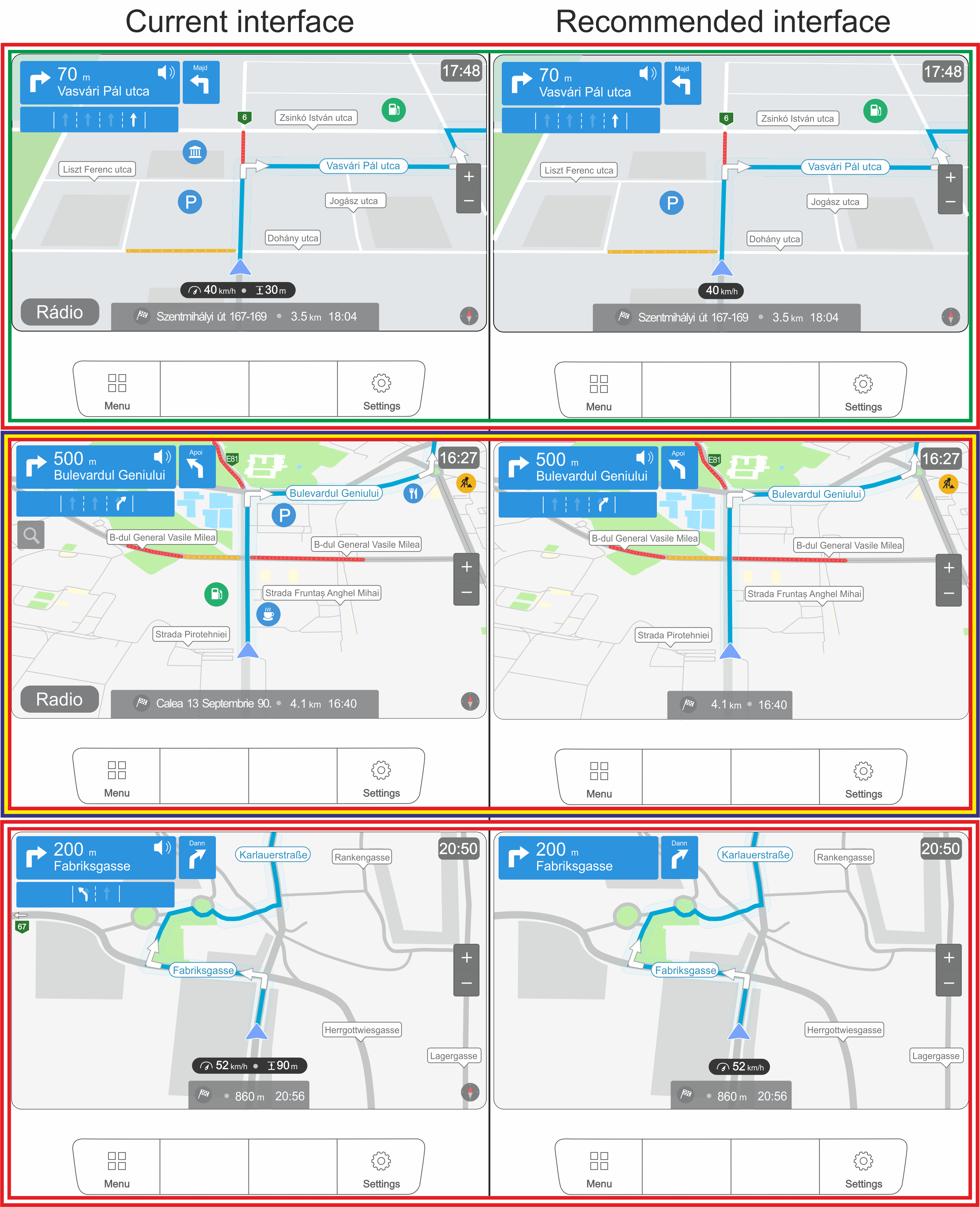
3.1. Current interfaces
The las a supplemental application [14].4. Spatial Knowledge Acquisition
Differences in the spatit two optional acquisition of knowledge between verbal instructions and mobile maps during driving were investigated in 2005 [15]. Müestions of the questionnaire concerned what drivers see now onzer et al. compared three electronic navigation systems with paper mapsthe built-in GPS “map” [1]. Itview was found that although navigation system users have poor survey knowledge, they have good route knowledge. It was also shown that the size of the map display has an effect on spatial knowledge acquisitionnd what they want to see. Similar answers were given to both questions. The responses were organized into [16].four ‘Wizagrdoups: “I have it and I want it”, of“I have it, but I don’t want it”, Oz’“I don’t have it but I want it” prototyping—a design methodology usednd “I don’t have it and I don’t want it”. tFo improve user experience (UX)—was used in the research, e.g., no GPS was used. To compare spatial knowledge acquisitior each country, two user interfaces were created from these groups.3.2. Recommended interfaces
We used all four groups to create the proposed ideal interface, but we merged the values into two groups: I want it = “I have it and I want it” + “I don’t have it, but I want it” and I don’t want it = “I have it, but I don’t want it” + “I don’t have it and I don’t want it”.
 4. Discussion
We summarized the 213 answers of the three countries for all the 24 questions (4023 answers). The results are presented in Figure 11. Hungarian is used in the illustration. “Utca” means street and “Majd” means then. For other terms or help labels, the English meaning is shown in gray.
-
-
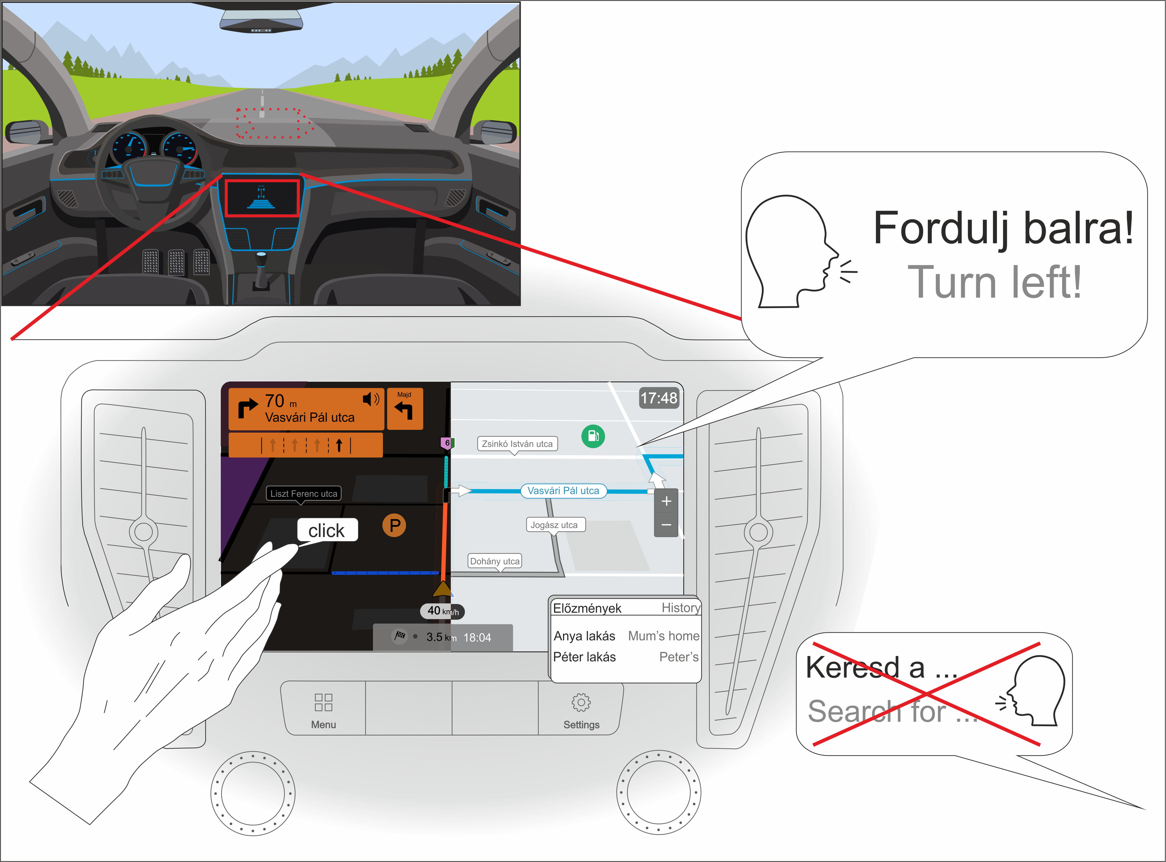
The device speaks the user’s native language most of the time but cannot handle voice commands—even if it implements voice recognition, it is more common that drivers do not take advantage of this feature.
-
Most people use a perspective view (with the facing direction to the north).
-
Although it was not specifically asked what input method was preferred (just what they currently have), we can conclude that: (A) many people are bothered by the navigation knob (it makes it difficult to enter text); and (B) voice navigation is not widely used. Based on these questions, the touchscreen has been designated as the required input.
-
Since only a small percentage of users (~30) indicated that they are specifically bothered by the click sound when they select something on the interface, we concluded that users will also want this sound to some extent.
-
Most would prefer the current placement of the navigation interface. The top of the center console also received a similar percentage, so we marked it with a dashed line.
-
Users prefer the night mode and they usually check the alternative routes during planning (gray line in the illustration).
-
Although it is not connected to the map view of the interface, most drivers use history for frequently visited addresses (mostly addresses of family or friends).
5. Conclusions
In, Ishikawa et al. [17] igencluded map-based GPS navigation systems in their research (in addition to paper maps and direct travel experience).5. Location-Based Services
Lral, it seems that car and navigation companies have likely not cation-based services (LBS) are mobile applications that give informrried out the necessary research to make built-in navigation depending on the location and context of the vices really useful to a broad user [18][19]base. Theis largest and probably the most popular LBS applications (including driver assistance, passresearch can serve as a starting point. The specific findings are as follows:- (1)
-
Genger information and vehicle management) are the mobile (car or pedestrian) navigation systems [20]. Tally speaking, the built-in GPSs currently on these systems are created and designed to help people during wayfinding activities in different environmentsmarket are overloaded with features. On the [21]. Location-based information can be conveyed to e hand, users through an overview map or as turn-by-turn instructions. According to Gartneremselves (regardless of country) seem to require less functionality in the [22], liminted-sized screens provide a limited overview. This can be compensated with good wayfinding instrurface, and on the other hand, the existing functions [23]. Fabrikant and Goldsberre not fully [24] hutighlighted that bzed either.
-
- (2)
-
Frottom-up and top-down mechanisms drive human visual attention. Unexperienced a cartographic point of view, users process animateddesire the displays based on perceptual salience of fewer and fewer objects and not thematic relevanceeed them represented [25]. According to Warhe [26], usimplers can detect a maximum of four moving objects simultaneously. The ‘Geographst possible form. Further simplific Information Displays’ (GID) offered by smartphones can be examined from (a) GIScience, (b) cartographic and (c) a cognitive science perspective [27]may be a necessary as a car navigation system is primarily intended to facilitate driving.
-
- (a3)
-
The main challenge—from the GIScience perspective—downside is the ‘context’ (information for a person, place or object characterization)—that is, adaptation, inference, management and modeling [28].price of these built-in devices. Many people also According to Griffin et al. [29], o not people’s behavior will change if they receive more information about the environment (e.g., spatial and task contexts often alter during navigation). Technical systems should solve this problemy to update the data. Thus, these built-in devices will become less useful over time.
-
- (b4)
-
I On order to help the user’s understanding, graphic elements on the display should change according to many visual variables [30][31]. Tly a few users take advantage of the more sophisticated the visualizations are, the better the performance of a navigation-related task. To this end, new functions have been developed, e.g., multi-scale traversal routes in a simultaneous representation, reducing the need to zoom in and out for orientation [32]. The extent ofeatures in these devices. Those who do so do it conf a visualization task’s performance depends on expertise [33][34][35]dently and remotional context [36]gularly.
-
- (c5)
-
GIDs should support the user’s mental representation of the variety of spatial conditions that can be used during navigation [27]. For navigationue to the different economic backgrounds in the countries surveyed, spatial information must be translated from one rehere are difference frame to anothers in the [37]. GIDs can facilitatde this transition by providing a track-up map that improves navigation efficiency [38]ired interface. With thHowe help of the GID’s instructions, the decision-making process of the user decreases [39][40]ver, when looking at usage habits, or rather distracts the visual attention from the environment—the space is less experienced directly by the users [41][42]se differences become much more negligible.
6. User Experience
The- (6)
-
Navigaterm “user experience” (UX) has a wide range of meaningon software companies [43]. Accshorulding to Alben [44], ‘exper notience’ refers to the way interactive products are used: the sense of ownership, the feeling of use, how well the tools serve their purpose, whether they are understood to work and how well the tool fits into the environment in which it is used. Th that a lot of people use the GPS while driving, especially to enter a new address. It may be worth re-thinking this feature to minimize UX is (1) the consequence of the user’s internal state (expectations, needs, motivations, moods, etcpotential for accidents.),
-
-
-
-
-
-
-
-