To assess Mars’ potential for both harboring life and providing useable resources for future human exploration, it is of paramount importance to comprehend the water situation on the planet. Therefore, studies have been conducted to determine any evidence of past or present water existence on Mars. While the presence of abundant water on Mars very early in its history is widely accepted, on its modern form, only a fraction of this water can be found, as either ice or locked into the structure of Mars’ plentiful water-rich materials. Water on the planet is evaluated through various evidence such as rocks and minerals, Martian achondrites, low volume transient briny outflows (e.g., dune flows, reactivated gullies, slope streaks, etc.), diurnal shallow soil moisture (e.g., measurements by Curiosity and Phoenix Lander), geomorphic representation (possibly from lakes and river valleys), and groundwater, along with further evidence obtained by probe and rover discoveries. One of the most significant lines of evidence is for an ancient streambed in Gale Crater, implying ancient amounts of “vigorous” water on Mars. Long ago, hospitable conditions for microbial life existed on the surface of Mars, as it was likely periodically wet. However, its current dry surface makes it almost impossible as an appropriate environment for living organisms; therefore, scientists have recognized the planet’s subsurface environments as the best potential locations for exploring life on Mars. As a result, modern research has aimed towards discovering underground water, leading to the discovery of a large amount of underground ice in 2016 by NASA, and a subglacial lake in 2018 by Italian scientists. Nevertheless, the presence of life in Mars’ history is still an open question. In this unifying context, the current review summarizes results from a wide variety of studies and reports related to the history of water on Mars, as well as any related discussions on the possibility of living organisms' existence on the planet.
- Mars
- water
- solar system
1. Introduction
1. Content
While a substantial portion of the existing water on Mars today is as ice, tiny water amounts are present as vapor in the atmosphere or as low-volume liquid brine that can be found in shallow soil areas. Bright material inferred to be ice can also be seen visually in exposures within new impact craters at high latitudes imaged by HiRISE (high-resolution imaging science experiment). On the surface of Mars, water can only be seen at the northern polar ice caps. Other places on Mars that contain significant amounts of water are at the south pole, where there is a permanent carbon dioxide ice cap, as well as in the shallow subsurface, where more moderate conditions exist. Detection of water on Mars’ surface, or close to it, shows the existence of more than 21 million km3 of ice, which would be able to cover the planet with water 35 m (115 ft.) deep. Much more ice is probably frozen into the profound subsurface.
Although some liquid water can be found now on the Martian surface, as a challenging environment for known life, it is confined to thin layers or dissolved atmospheric moisture. Since the average atmospheric pressure on the planet’s surface is approximately 600 pascals (0.087 psi), lower than the melting point of water’s vapor pressure, no significant amount of liquid water exists on the surface; typically, if pure water on the Martian surface were heated to more than its melting point, it would become vapor; otherwise, it would freeze. In addition, brines have a significant impact on lowering water activity/vapor pressure over solution, and hence reducing the evaporation rate and prolonging the lifetime of liquid water/brine exposed to the Martian atmosphere. Mars probably had higher surface temperatures, as well as a denser atmosphere, 3.8 billion years ago, which resulted in large amounts of surface water that may have contained a vast ocean, possibly covering one-third of the planet. It seems that there was water flowing across the surface for short amounts of time at different periods in Mars’ history. According to NASA’s report on December 9, 2013, obtained from the Curiosity rover, which is studying Aeolis Palus, an aged freshwater lake used to exist in Gale Crater, where there may have been an environment for microbial life. Much evidence shows the notable role of water ice in Mars’ geologic history, due to a considerable amount of it on the planet.
Additionally, Martian achondrites provide clear evidence for the water presence over time. These rocks can be considered the key to get clues about the primary geologic processes at work in Mars, identify its ancient hydrothermal environments, search for traces of life forms, and study the interaction of water in sample returned rocks. In addition, as they can be accurately dated, they can provide a message in a bottle: unique information of the key regions in which future missions should focus to extract the maximum scientific information on the key questions to be answered in future robotic and manned sample-return missions to the red planet.
2. Evidence from Rocks and Minerals
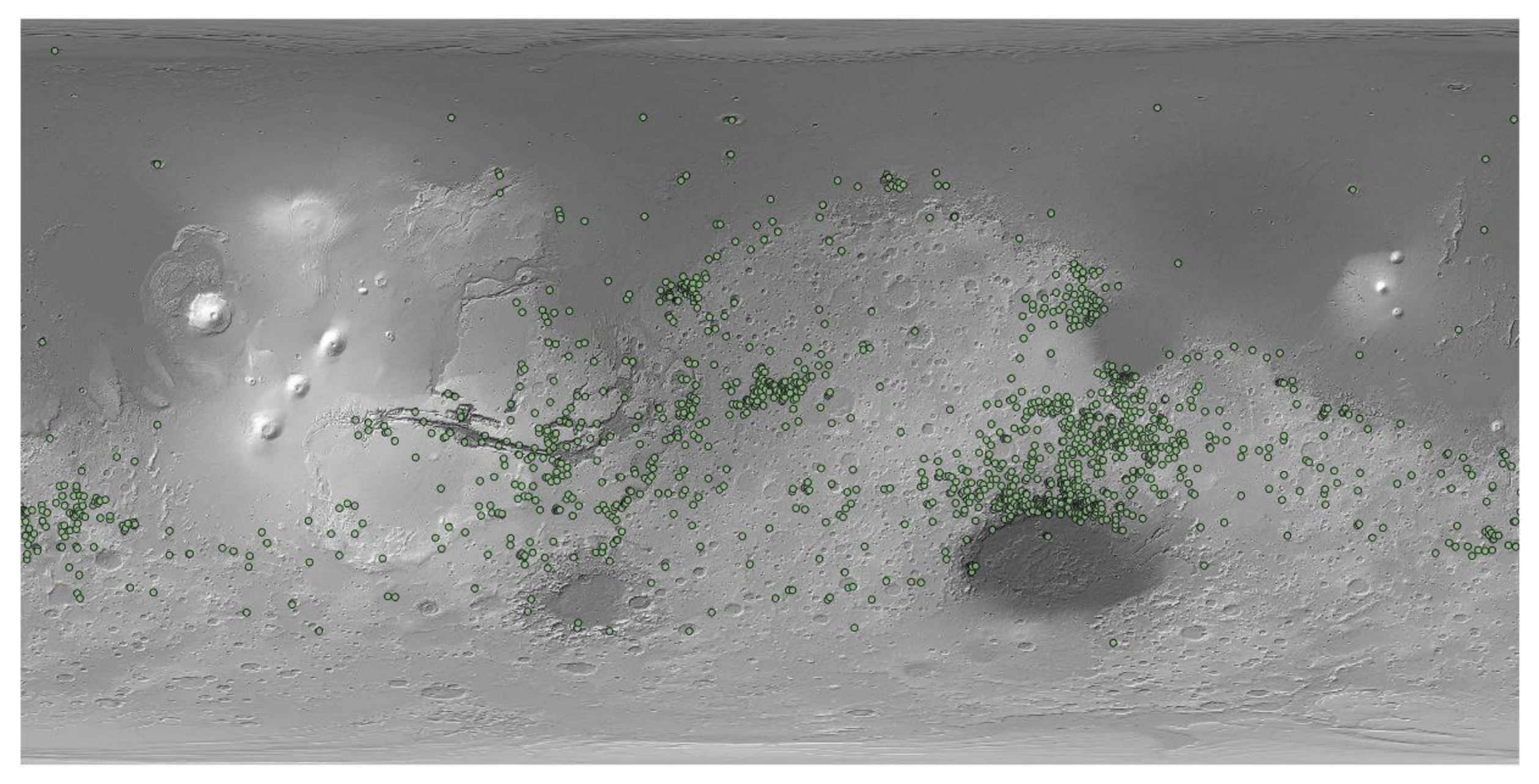
Regardless of the existence of abundant water rather early in Mars’ history, which is widely accepted, none of those vast areas of liquid water remain. Modern Mars has a fraction of this water as either ice, or clogged in the structures of plentiful water-rich materials, comprised of sulfates and clay minerals (phyllosilicates). The principal sources of water on Mars, which is equivalent to 6% to 27% of the Earth’s present ocean, are asteroids and comets from more than 2.5 astronomical units (AU), based on investigations of hydrogen isotopic ratios. The spectro-imaging instrument (OMEGA) on Mars Express provided the first detection of hydrated minerals on Mars. The data indicated that large amounts of liquid water had once survived for long periods on the planet’s surface. The OMEGA has mapped almost the entire surface of the planet (Figure 1), typically at a resolution between one and five kilometers, with some areas at sub-kilometer resolution.
Figure 1. Mars’ hydrated minerals map.
3. Geomorphic Evidences
A revolution in ideas, concerning water on Mars, was caused by the 1971 Mariner 9 spacecraft, which discovered immense valleys in many areas (Figure 2). Breaking through dams, eroding grooves into bedrock, and carving deep valleys are some physical change examples caused by water floods that were displayed in its images. Given the areas of branched streams that were seen in the southern hemisphere of the planet, falling rain in the past is probable. The number of identified valleys has increased through time. Maps of 40,000 river valleys on Mars were shown by research published in June 2010, which is approximately four times more than the number of river valleys recognized earlier.
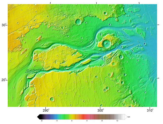
Figure 2. Kasei Valles—a major outflow channel—seen in Mars orbiter laser altimeter (MOLA) elevation data. The flow was from the bottom left to right. The image is approx. 1600 km across. The channel system extends another 1200 km south of this image to Echus Chasma.
Inverted relief, probably occurring due to cementation, leads to increased resistance of deposits on stream beds from erosion and can be found in some parts of Mars; thus, when the covering layer is ultimately removed by erosion, the former streams become visible. Figure 3 shows this phenomenon.
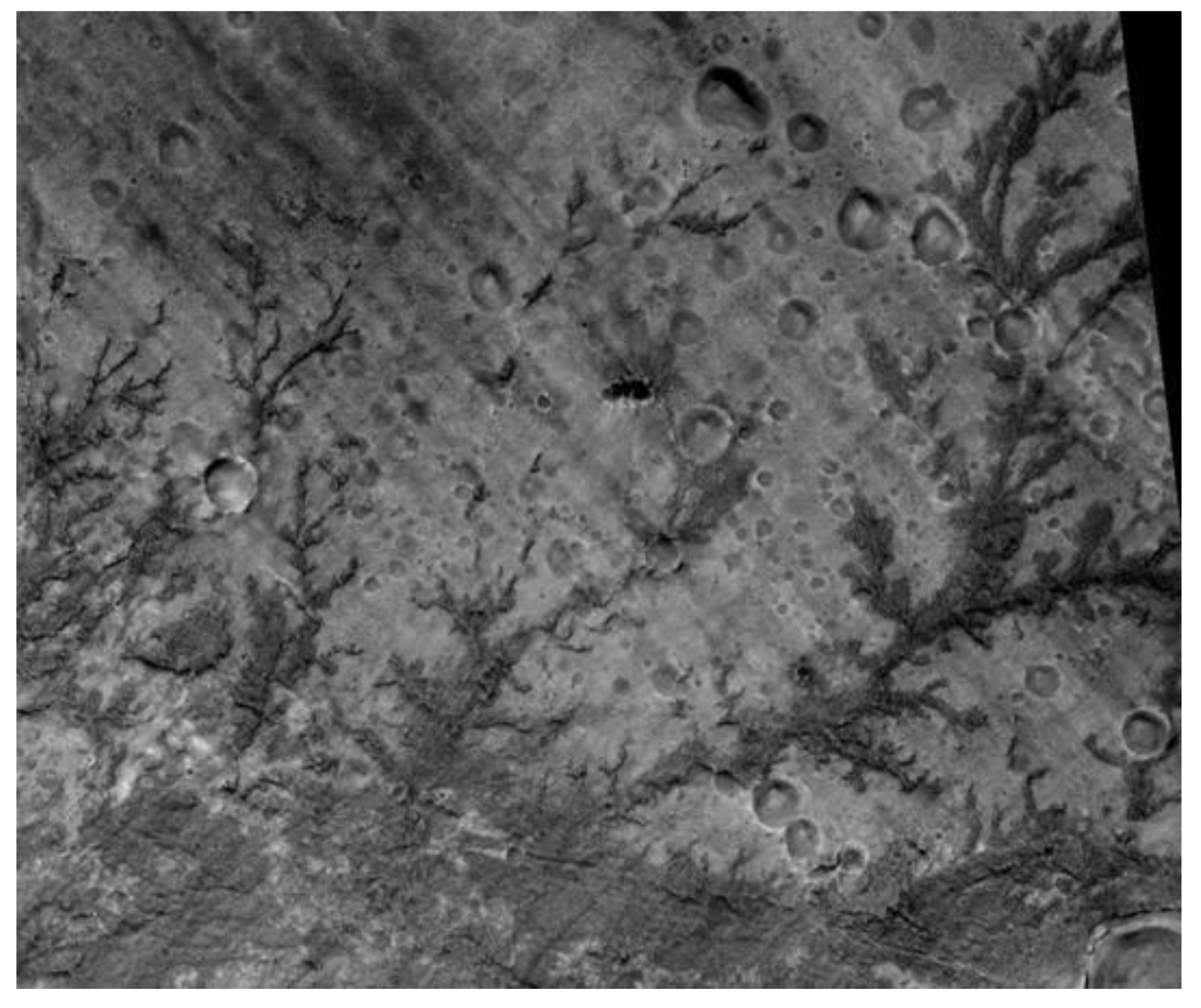 Figure 3. Inverted stream channels in Antoniadi Crater. Location is Syrtis Major quadrangle.
A hypothesized ancient lake is Eridania Lake, having a surface area of approximately 1.1 million square kilometers. Its volume is about 562,000 km3, and its depth, in the deepest part, reaches up to 2400 m (Figure 4). It had more water compared with all other Martian lakes collectively and was larger than the Caspian Sea, which is the largest landlocked sea on Earth. In fact, the amount of water once held by Eridania Lake would have been nine times greater than all of the Great Lakes, located in North America.
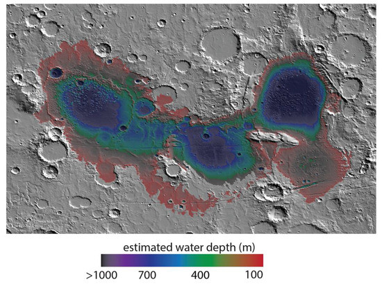
Figure 4. Map showing estimated water depth in different parts of the Eridania Sea. This map is about 530 miles across.
De Map shosits with thicknesses greater than 400 m, found by research with the compact reconnaissance imaging spectrometer for Mars (CRISM), contained Fe- and Mg-serpentine, Fe-rich mica (for instance, glauconite-nontronite), Mg-Fe-Ca-carbonate, Fe-sulfide, saponite, and talc-saponite (Figure 5)wing estimated water depth in different parts of the Eridania Sea. This map is about 530 miles across.
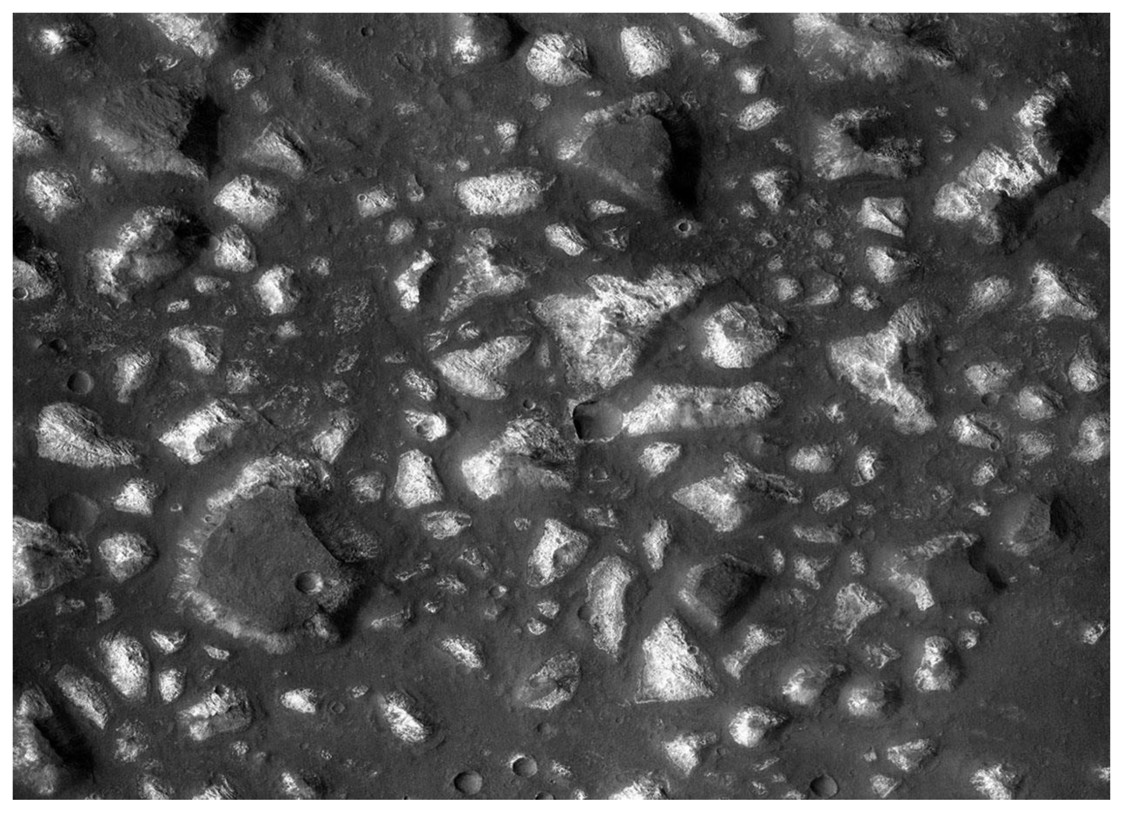
Figure 5. Deep-basin deposits from the floor of the Eridania Sea. The mesas on the floor are there because they were protected against intense erosion by deep water/ice cover. CRISM measurements show minerals may be from seafloor hydrothermal deposits.
Several deltas formed in Martian lakes have been reported by researchers (Figure 6). The existence of a significant amount of liquid water can be inferred by finding deltas. In order to form deltas, it is necessary to have deep water over a long period of time.
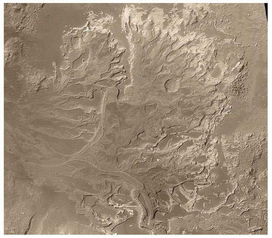
Figure 6. Delta in Eberswalde crater.
It is now accepted, by most authors, that groundwater seepage processes at least somewhat affect and shape most valley networks. Additionally, groundwater may have had an important impact on controlling large-scale sedimentation patterns and processes on Mars. Based on this hypothesis, when groundwater that contained dissolved minerals reached to the surface, it helped to cement sediments and form layers by adding minerals, especially sulfate. In fact, groundwater may form some layers by cementing loose aeolian sediments and raising depositing minerals (Figure 7).
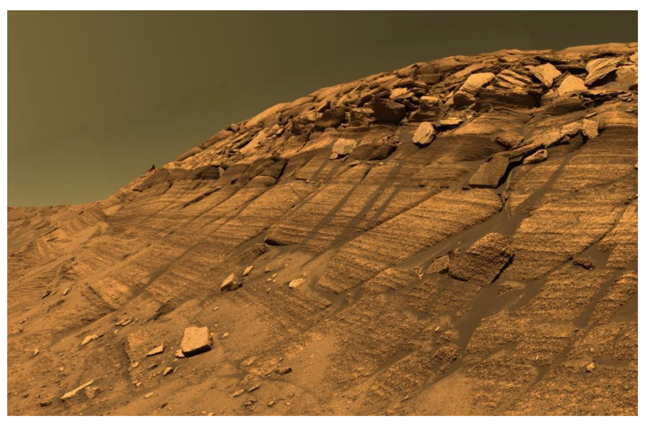
Figure 7. The preservation and cementation of aeolian dune stratigraphy in Burns Cliff in Endurance Crater are thought to have been controlled by the flow of shallow groundwater.
It is still controversial among scientists whether a primordial Martian ocean exists on Mars or not (Figure 8). Additionally, the challenge remains to better interpret some of its characteristics as ‘ancient shorelines’. Evidence for the existence of an ancient Martian ocean was first announced by scientists in March 2015.
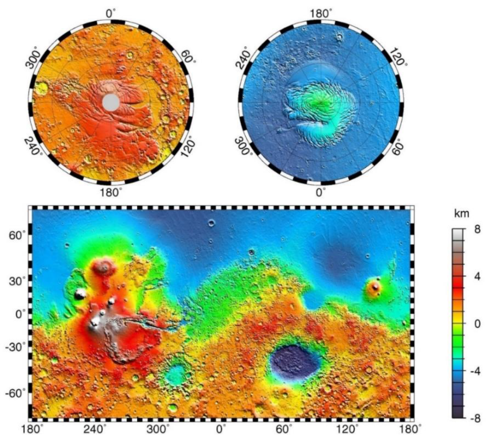
Figure 8. The blue region of low topography in the Martian northern hemisphere is hypothesized to be the site of a primordial ocean of liquid water.
NASA’s Mars Exploration Program has prepared the Subsurface Water Ice Mapping (SWIM) (Figure 9) for the Northern Hampshire of Mars. In Figure 9, Blue shaded regions show where the data are consistent with the presence of subsurface ice, while the red ones indicate inconsistencies between data and the presence of subsurface ice.

Figure 9. Subsurface water ice consistency map for the northern hemisphere of Mars.
During the winter, the thickness of the northern (Planum Boreum) and southern (Planum Australe) polar ice caps increases, but they partially decrease in the summer, owing to sublimation (Figure 10).
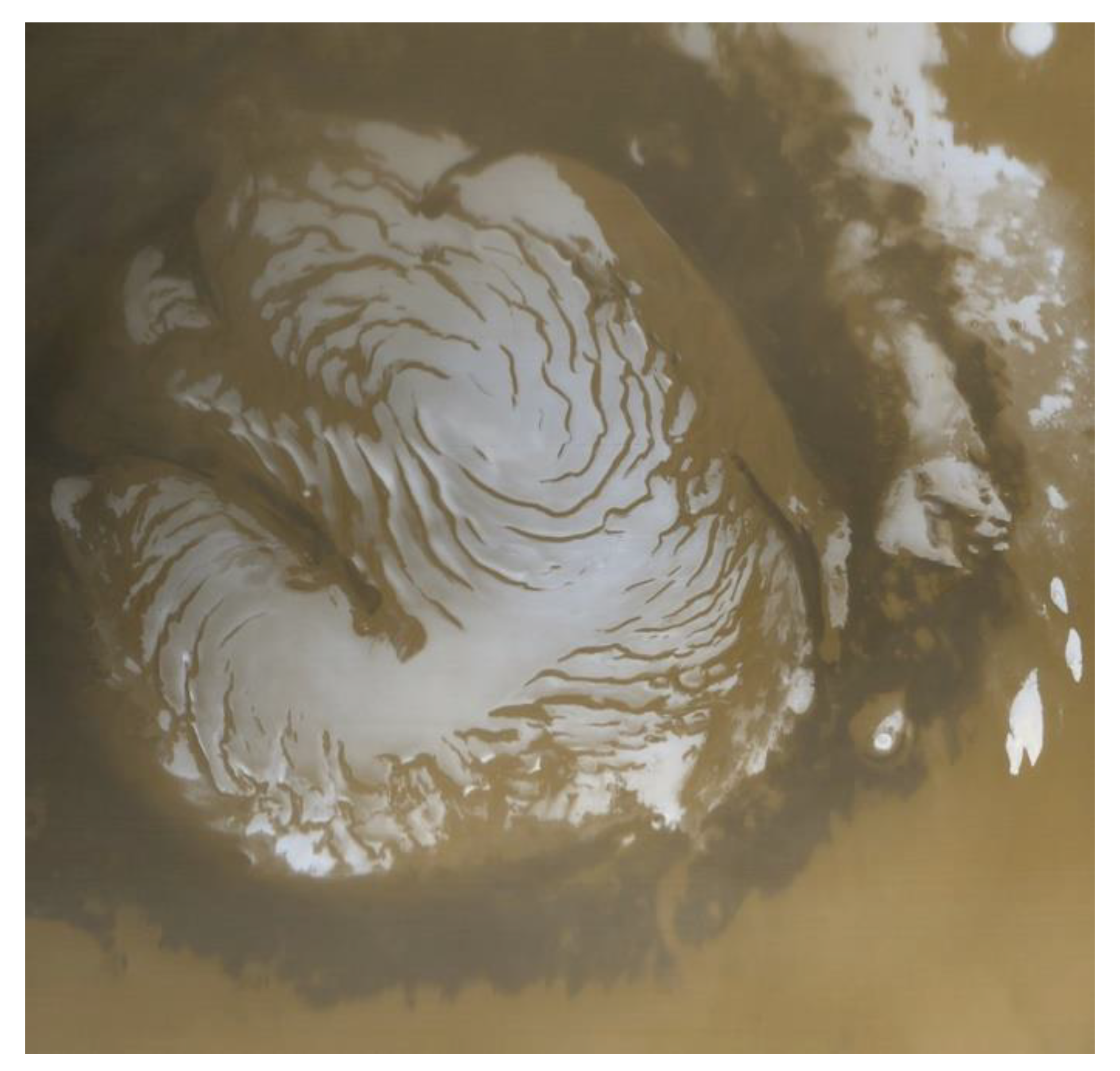
Figure 10. The Mars Global Surveyor acquired this image of the Martian north polar ice cap in early northern summer.
Expansion of the ice depth to up to 3.7 km (2.3 mi) below the surface in the southern polar cap was reported in 2004 by the Mars advanced radar for subsurface and ionosphere sounding (MARSIS) radar sounder from the Mars Express satellite (Figure 11).
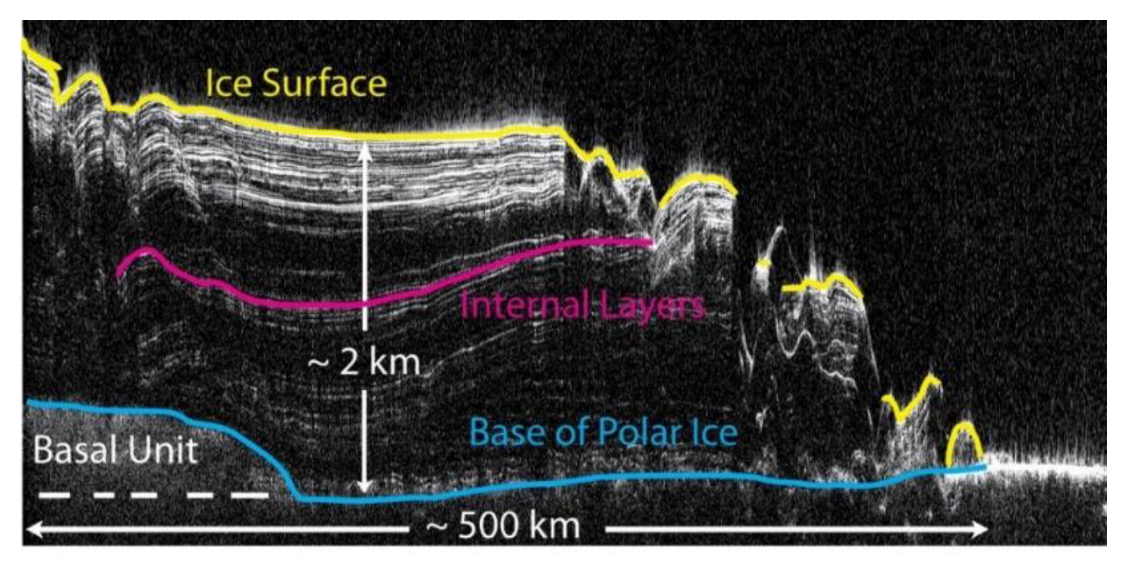
Figure 11.
In 2017, an image from the HiRISE camera onboard the Mars Reconnaissance Orbiter (MRO) demonstrated at least eight eroding slopes, indicating exposed water ice sheets with 100-m thickness, coated by one or two meters of a soil layer (Figure 12).
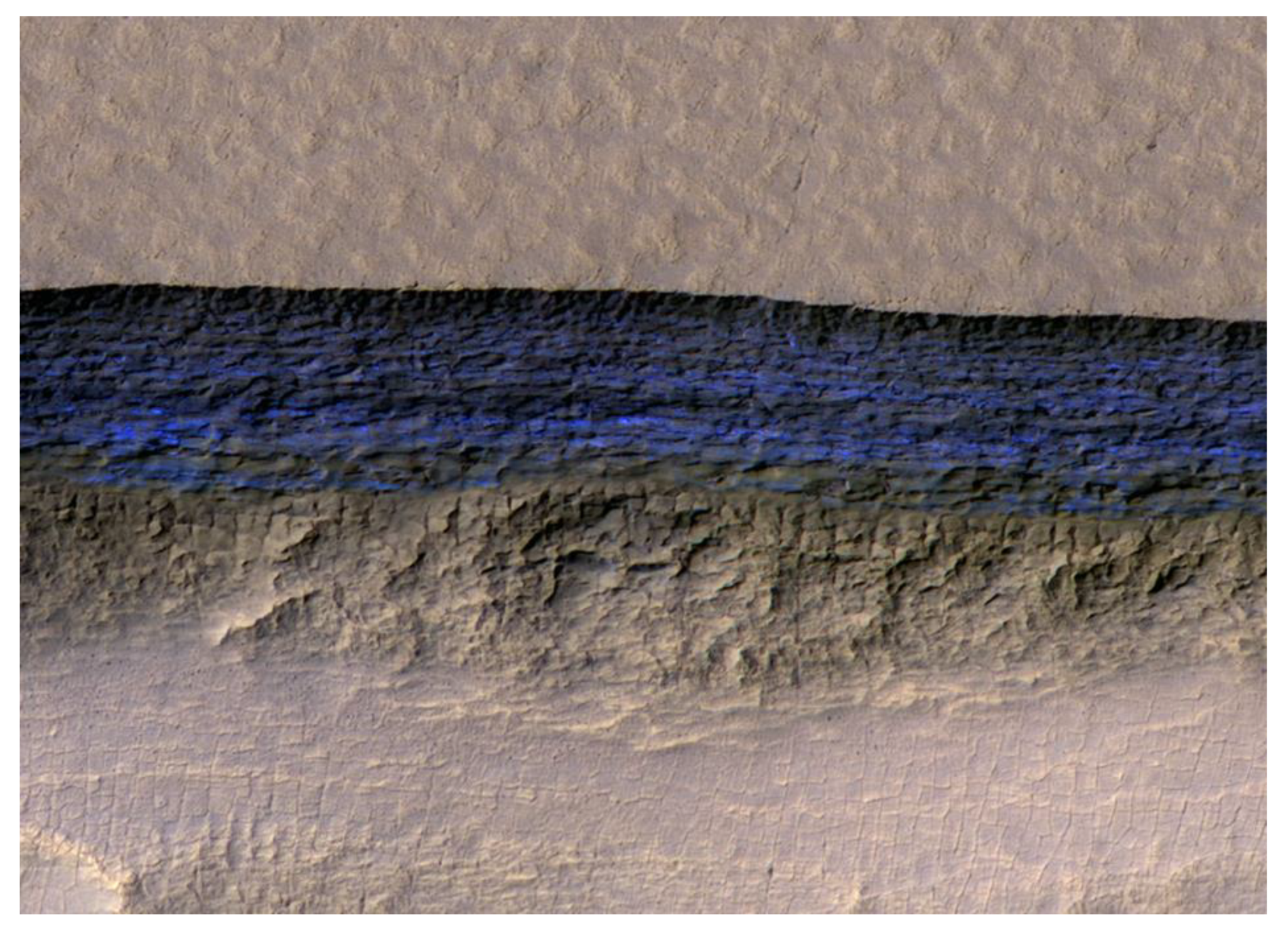 Figure 12. A cross-section of underground water ice is exposed at the steep slope that appears bright blue in this enhanced-color view from the Mars Reconnaissance Orbiter (MRO). The scene is about 500 m wide. The scarp drops about 128 m from the level ground. The ice sheets extend from just below the surface to a depth of 100 m or more [177,178].
When ice moves, it transfers rock materials. This phenomenon usually occurs at the snout or edges of the glacier (Figure 13). This characteristic is known as moraines on Earth; on Mars, however, it is commonly identified as concentric ridges, arcuate ridges, or moraine-like ridges.
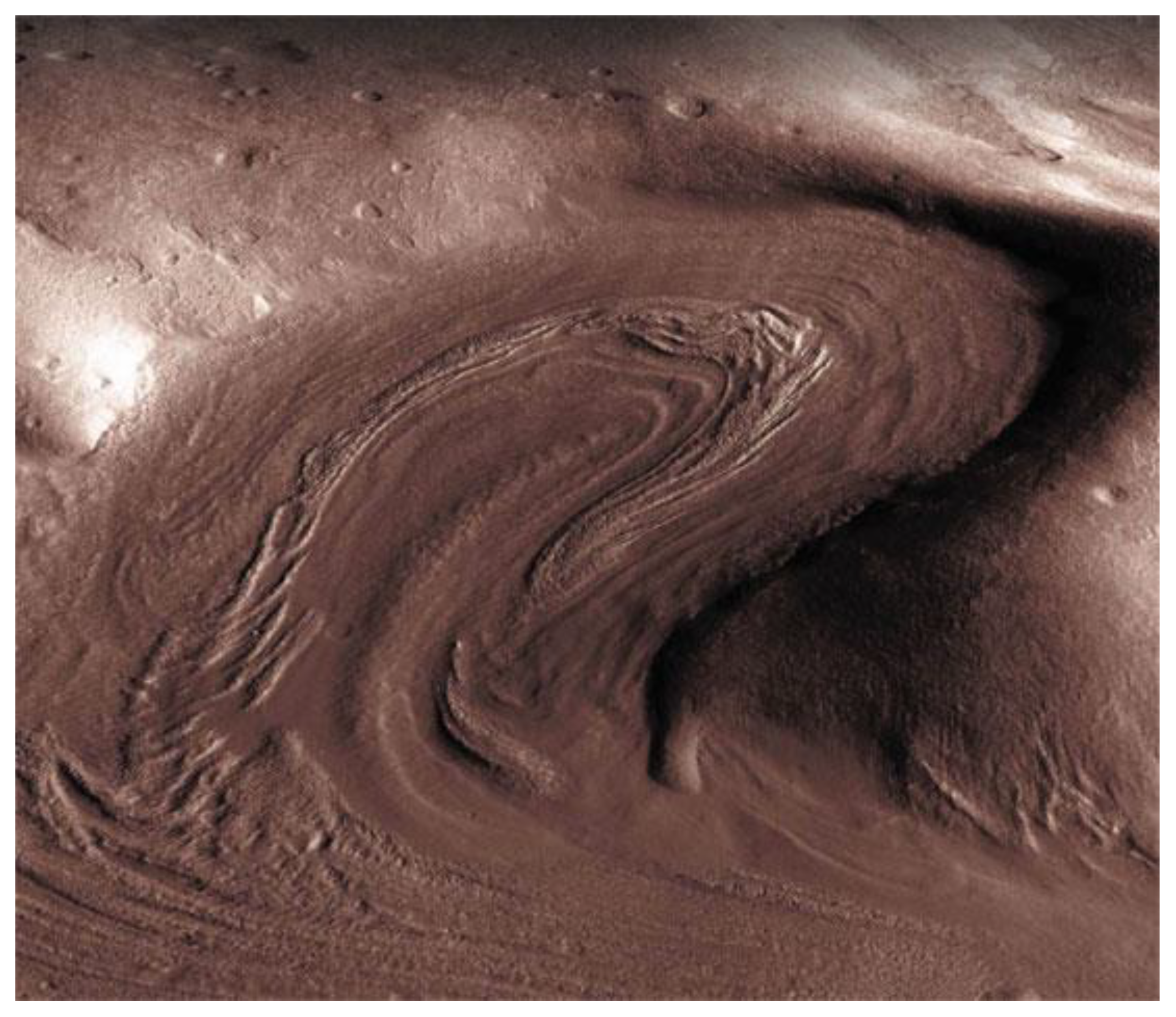 Figure 13. View of a 5-km-wide, glacial-like lobe deposit sloping up into a box canyon. The surface has moraines, deposits of rocks that show how the glacier advanced.
4. Evidence for Recent Flows
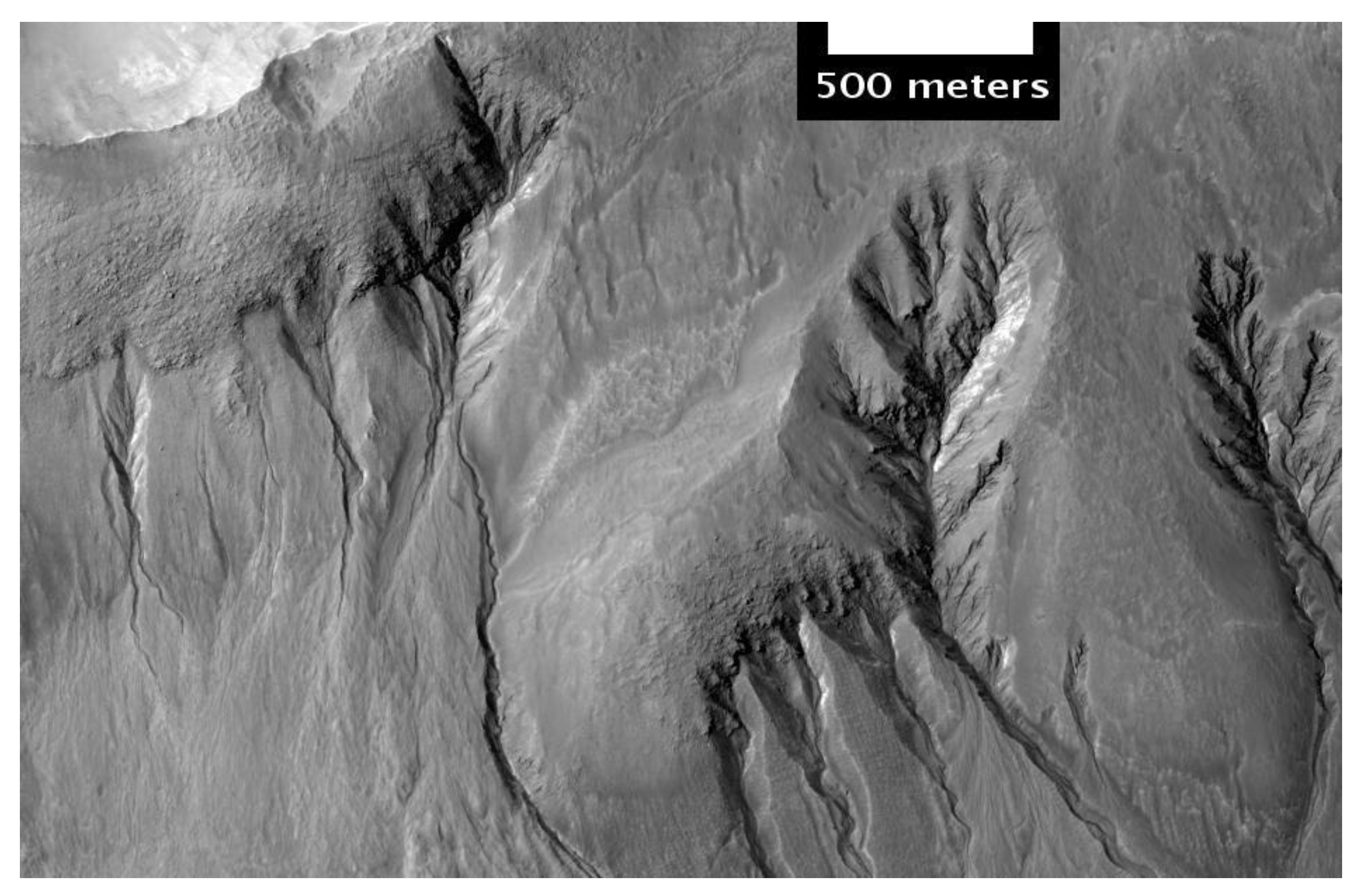
The current low temperature and atmospheric pressure make it improbable for pure liquid water to exist in a stable form on Mars. However, water may be located at the lowest elevations for short periods of time. Hence, after the observation of gully deposits by NASA’s Mars Reconnaissance Orbiter in 2006, which were not present ten years earlier, a geological mystery began. During the warm months on Mars, liquid brine flows on the surface, which may play the primary role in forming these gullies (Figure 14)
The first direct indication of Mars having water in the past comes from dry river beds and canyons found from the images obtained using the Mariner 9 Mars orbiter after its launch in 1971. These include over 4020 km (2500 mi) of canyons in a system, which is called Valles Marineris (Figure 15).
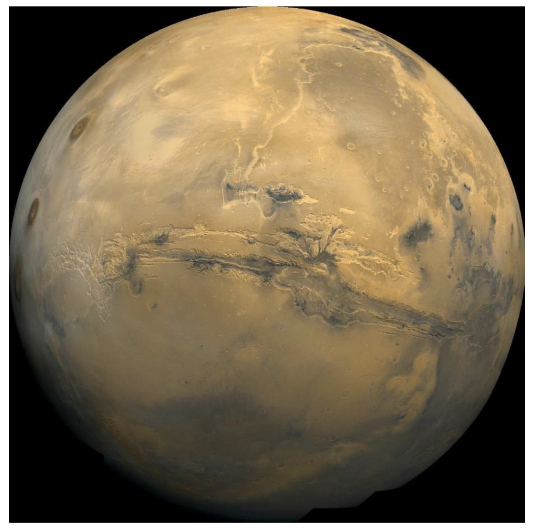 Figure 15. The Valles Marineris canyon system.
Mars’ surface mineral composition could be specified from the Mars Global Surveyor’s Thermal Emission Spectrometer (TES), which can provide information related to the history of water’s presence or absence on Mars. Further, TES was used in studying the formation of Nili Fossae, which is comprised of the mineral olivine (Figure 16).
 Figure 16. Map showing the distribution of hematite in Sinus Meridiani. This data was used to target the landing of the Opportunity rover that found definite evidence of past water.
Calculations based on available data in 2002 showed that a layer of water covering all soil surfaces would be equivalent to a global layer of water (GLW) 0.5–1.5 km (0.31–0.93 mi) deep. Evidence from many images provided by the Odyssey orbiter indicate that there were once large amounts of water flowing across Mars’ surface. Layers that probably formed under lakes, as well as patterns of branching valleys, and river and lake deltas, can all be inferred from the images (Figure 17).
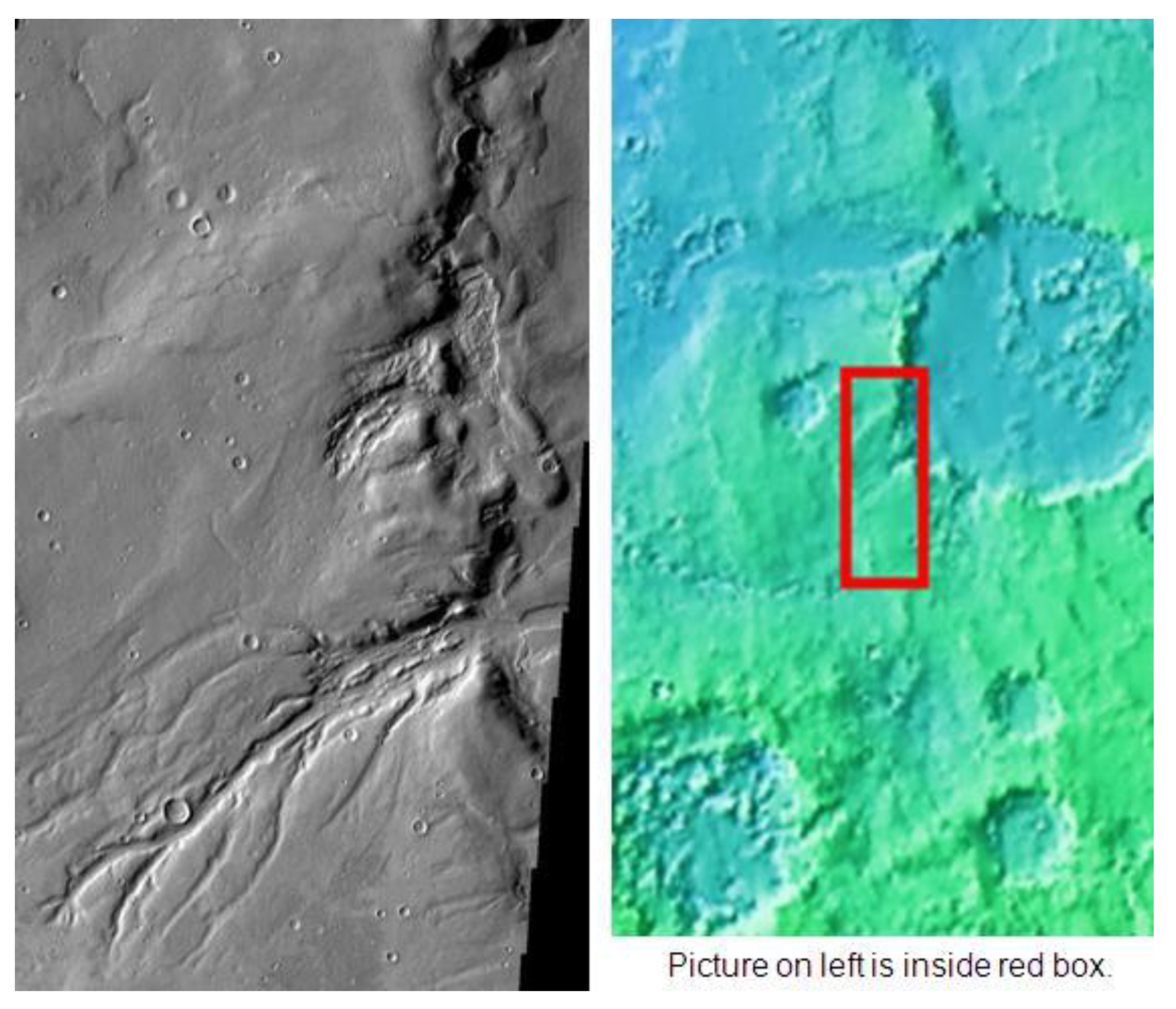 Figure 17. The complex drainage system in Semeykin Crater. Location is the Ismenius Lacus quadrangle.
Soil and melting ice were splashed onto the vehicle due to the retrorockets during the Phoenix’s landing (Figure 18). This left material on the landing struts during landing, as shown by photographs. This material then expanded in a way that resembled deliquescence, as it got darker before it disappeared, which is what happens when something liquefies and then drips. The material was probably liquid brine droplets, which can be inferred from the thermodynamic evidence and these observations.
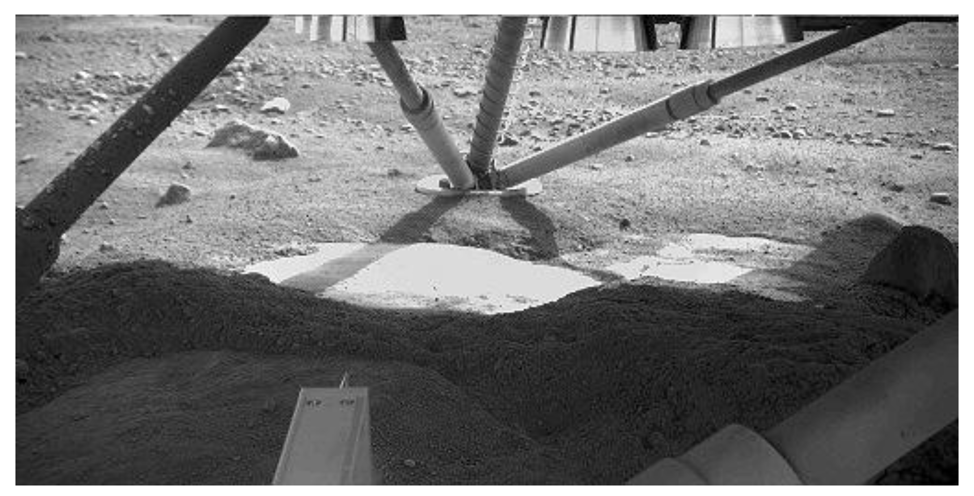 Figure 18. View underneath Phoenix lander showing water ice exposed by the landing retrorockets.
It seemed from the camera that the landing site was flat. However, there were some polygons that were surrounded by what appeared to be troughs 20–50 cm (7.9–19.7 in) deep (Figure 19). Expansion of ice in the soil and its contraction, owing to notable temperature variations, are the main reasons for polygons to be formed.
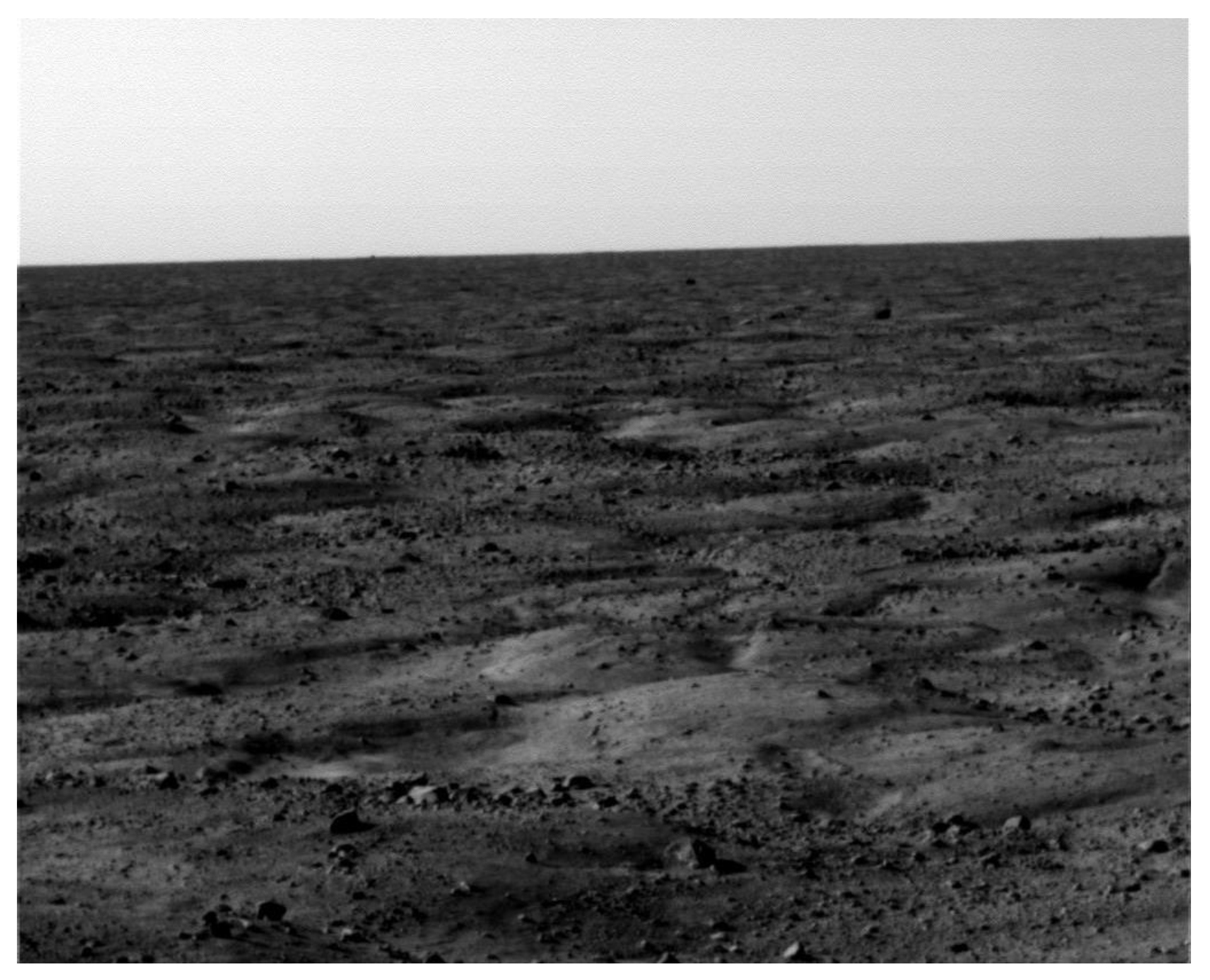 Figure 19. Permafrost polygons imaged by the Phoenix lander.
A significant amount of hematite was shown from orbit in a site to which the Opportunity rover was directed. Hematite concretions and layered rocks that were marbled, were also found by the rover (Figure 20). On Opportunity’s transverse, in the Burns Cliff area of the Endurance Crater, the rover examined aeolian dune stratigraphy. Opportunity’s operators realized that shallow groundwater played a principal role in the preservation and cementation of the outcrops (Figure 21).
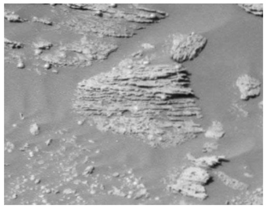
Figure 20. Thin rock layers, not all parallel to each other.
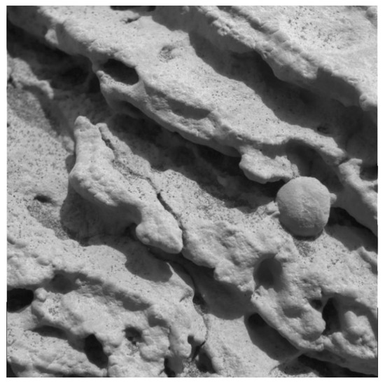
Figure 21. Close-up of a rock outcrop.
The Mars Reconnaissance Orbiter’s HiRISE instrument obtained several images that show strong evidence that on Mars, there is a history of water-related processes. Obtaining an indication of ancient hot springs was its main discovery (Figure 22).
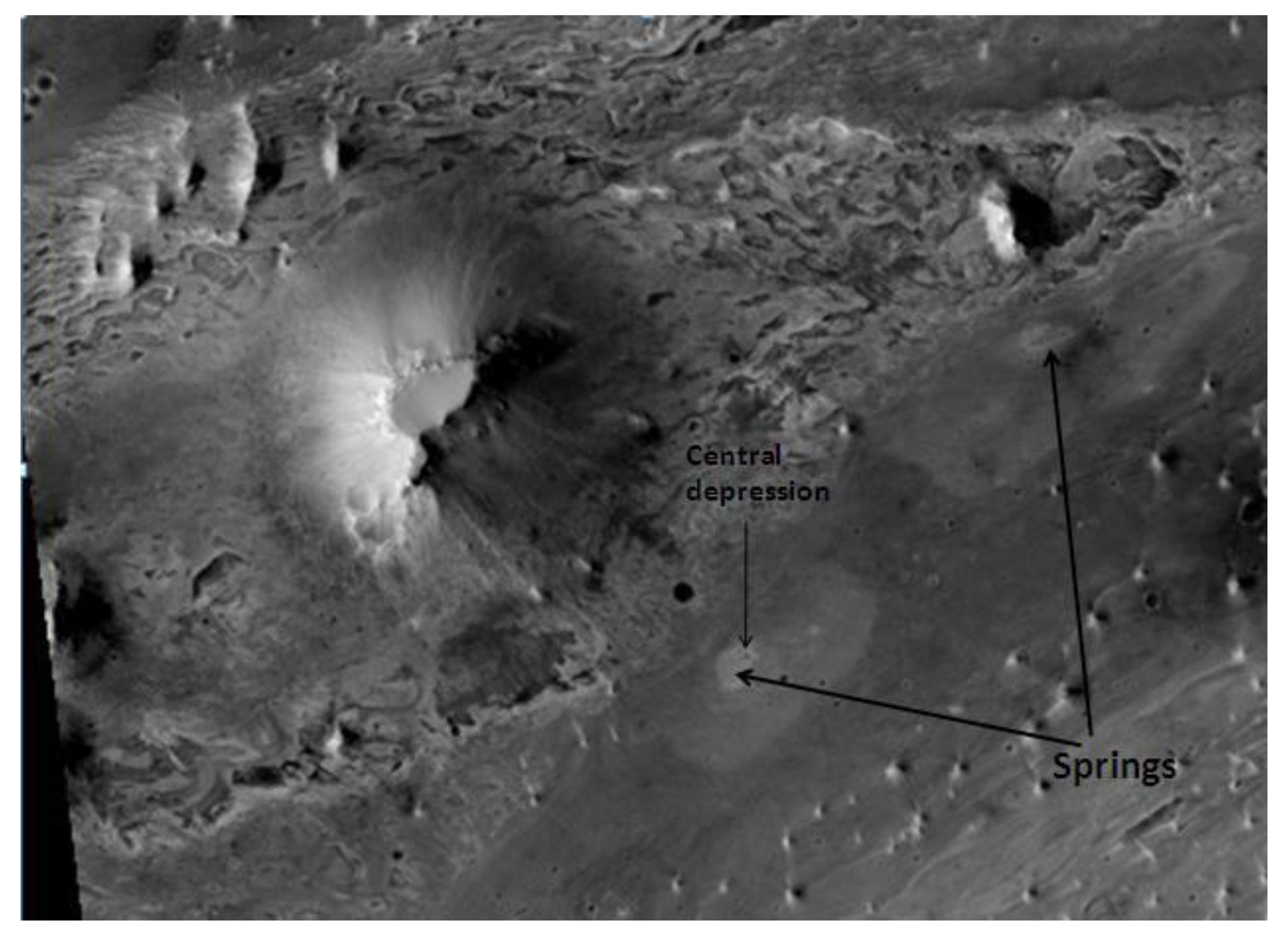
Figure 22. Springs in Vernal Crater, as seen by HiRISE. These springs may be good places to look for evidence of past life, because hot springs can preserve evidence of life forms for a long time. Location is the Oxia Palus quadrangle.
NASA’s Curiosity rover detected unequivocal fluvial sediments when it was at the beginning stages of its continuing mission. An earlier robust flow in a streambed, containing water between waist and ankle-deep, was expected given the characteristics of the pebbles in these outcrops (Figure 23). These rocks were discovered at the base of an alluvial fan system, which came from a crater wall although they had already been recognized from orbit. In October 2012, Curiosity accomplished an X-ray diffraction analysis of soil from Mars for the first time. The presence of various minerals, including feldspar, pyroxenes, and olivine was revealed. Therefore, it was inferred that the soil in the analyzed sample was similar to the weathered basaltic soils that are found in Hawaiian volcanoes. The composition of local fine sand and dust, disseminated from global dust storms, was also found in the sample. So far, the results from the materials analysis by Curiosity are in line with the initial ideas related to the Gale Crater area deposits, which seem to show that a transition from a wet to dry environment happened on the planet over time. The existence of sulfur, chlorine, and water molecules in the soil of Mars was announced by NASA in December 2012, when Curiosity implemented its first extensive soil analysis. Additionally, from the various rock samples analyzed, including the broken pieces of “Tintina” rock and “Sutton Inlier” rock, along with the nodules and veins in other rocks, like “Knorr” rock and “Wernicke” rock, NASA announced in March 2013 clues for the presence of mineral hydration, which was most likely hydrated calcium sulfate.
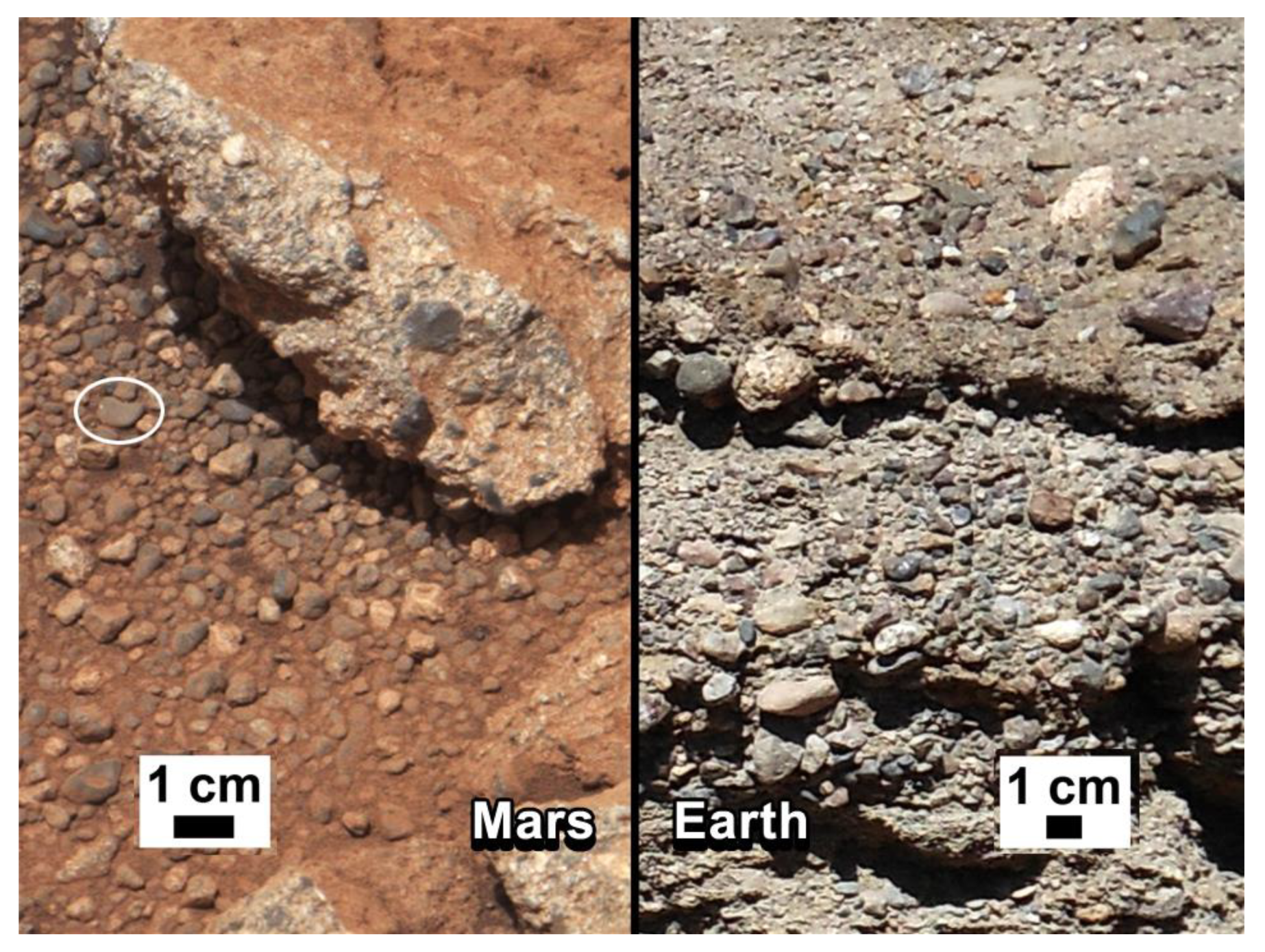
Figure 23. Rock outcrop on Mars—compared with a terrestrial fluvial conglomerate—suggesting water “vigorously” flowing in a stream.

