Your browser does not fully support modern features. Please upgrade for a smoother experience.
Please note this is a comparison between Version 2 by Amina Yu and Version 3 by Amina Yu.
The Sixtymile gold district, Yukon, Canada has been mined for placer gold since the late 19th century.
- Sixtymile gold district
- Yukon
- Canada
- Gold
1. Introduction
The Sixtymile mining district in the Yukon Territory, Canada is located in the Sixtymile River watershed which is ~75 km west of Dawson City and ~10 km east of the border with Alaska, USA (Figure 1). Since the late 19th century, it has been known primarily for its placer gold deposits, and is proximal to the Klondike Mining district—the site of the famous Klondike Gold Rush. The main streams that were mined in the district are the Bedrock, Big Gold, Little Gold, Glacier, and Miller [1] (Figure 2). Combined, these creeks likely produced >400,000 ounces of gold from 1892–2005 [2]. Placer gold deposits in this mining district, and in the vicinity, occur both in low-level creek gravels (valley bottoms), and in low- and high-level terraces (resting on schist bedrock) that were mainly formed by aggradation and incision associated with phases of glaciation and deglaciation in the past ~40 ka [3][4].
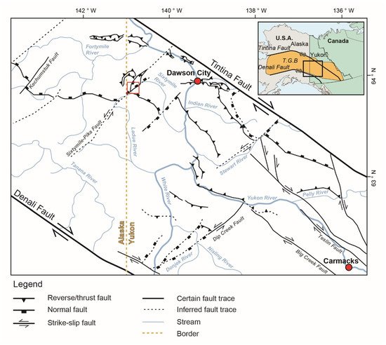
Figure 1. Regional structures in the Alaska-Yukon region (modified after Allan et al., 2013) [5]. Inset map shows the location of the Tintina Gold Belt (T.G.B.). The focused area (red box) is located close to the Alaska–Yukon border and lies within an area interpreted as a pull-apart basin resulting from left stepover on the left-lateral Sixtymile-Pika Fault.
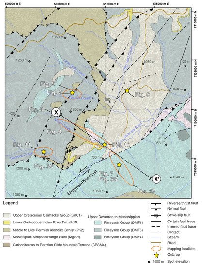
Figure 2. Local geology of the Sixtymile area which consists of a range of units which span the Mesozoic and Paleozoic (modified after maps by Mortensen, 1996, and the Yukon Geological Survey, 2020) [6][7]. Abbreviations of geological formations are from the Yukon Geological Survey (2020). Contour interval is 20 m.
The interpreted bedrock sources for gold in the region are Jurassic orogenic (mesothermal) gold deposits hosted in uplifted and exhumed greenschist facies rocks [8]. Prospectors have historically taken advantage of the proximity between exposed bedrock occurrences and placer deposits for their investigations on the location of orogenic veins [9][10].
However, almost 120 years since the Yukon placer gold rush, little is known about the structural setting of bedrock gold occurrence in the region [8][11][12]. A recent increase in demand for gold has prompted the exploration of new minable placer gold deposit sites and lode deposits [13]. Yet, there has only been small, incremental progress in bedrock mining due to the poor exposures, and consequently, insufficient knowledge of the bedrock geology [14]. In the main Klondike Gold district, placer gold has been suggested by geochemical signatures and microchemical characterizations to originate from a local bedrock source, and that these sources are associated with intrusions and/or hydrothermal/epithermal auriferous quartz veins within the underlying Klondike Schist [15][16][17].
2. Geologic Background
The Sixtymile mining district lies in the Tintina Gold Belt that spans more than 1000 km along the North American Cordillera (Figure 1). The Tintina Gold belt hosts diverse types of gold deposits (for example, orogenic, intrusion-related epithermal, porphyry, skarns and so on) that developed as a result of Late Jurassic to Late Cretaceous arc magmatism. The initiation of plutonism and fluid migration in the region supposedly correlates well with the onset of oblique subduction, and movement of the major right-lateral strike-slip Denali, Tintina, and associated fault systems [5][18][19]. The ~150 km-long Sixtymile-Pika Fault (Figure 1), a Late Cretaceous, NE–SW-striking, sinistral strike-slip fault system, with possibly up to ~30 km of displacement, is a major ‘orogen-perpendicular’ structure that runs through the Sixtymile mining district [5][6][20][21]. Previous regional analyses suggest this fault possibly exerted a structural control on Late Cretaceous localization of intrusions and volcanic deposits, as well as porphyry, skarn, and epithermal style deposits and occurrences in the region, which include high-grade gold (up to ~20 g/t) [22][23].
The geology of the Sixtymile district is characterized by a range of Mesozoic to Paleozoic units (Figure 2), that were originally documented in detail and given abbreviations, by MacKenzie et al. (2008) [8]. The area is underlain by a basement composed of stacked thrust slices including the Upper Devonian to Mississippian Finlayson Group (DMF1, 3 and 4), Mississippian Simpson Range Suite (MgSR), Middle to Late Permian Klondike Schist (PK2), and Carboniferous to Permian Slide Mountain Terrane (CPSM4), which are overlain by the Lower Cretaceous Indian River Formation (lKIR) and the Upper Cretaceous Carmacks Group (uKC1) [78][87].
The Upper Devonian to Mississippian Finlayson Group exposed in the area is composed of intermediate to mafic volcanic and volcaniclastic rocks, and mafic metamorphic rocks (DMF1); carbonaceous metasedimentary rocks, which includes the Nasina Schist (DMF3); and fine-grained siliciclastic and metavolcaniclastic rocks (DMF4) (Yukon Geological Survey, 2020). The Mississippian Simpson Range Suite (MgSR) consists of foliated to strongly foliated, fine to medium-grained granodiorite to tonalite rocks [7]. The Middle to Late Permian Klondike Schist includes felsic, intermediate and, mafic metavolcanics intercalated with metaclastic rocks. While the Klondike Schist in the area was mapped by the Yukon Geological Survey (2020) [7] as mostly muscovite and/or chlorite quartz phyllite and quartzites (PK2), greenschist facies chloritic, quartzofeldspathic, and micaceous schists, similar to those described by Mortensen (1990) [24] in the Klondike field, can also be found in the area. The Carboniferous to Permian Slide Mountain Terrane (CPSM4) is composed mostly of serpentinized ultramafic rocks [7]. The Lower Cretaceous Indian River Formation (lKIR) is a sedimentary sequence dominated by clast-supported, pebble-to-cobble conglomerate with clasts composed of vein quartz, foliated quartzite, sandstone, and tuff [25]. The lKIR is unconformably overlain by the Upper Cretaceous Carmacks Group (uKC1) is a volcanic succession of mostly mafic (for example, basalt), and to a lesser extent intermediate (for example, andesite), and locally felsic (for example, trachyte) layers, usually with a base that exhibits a downward transition from coarse clastic sedimentary rocks (for example, conglomerate) into an autochthonous basement breccia [26].
In the nearby Klondike district, Mackenzie et al. (2008) [8] proposed a structural evolution that consists of five deformation stages, which due to proximity, possibly also governs the structural setting of the Sixtymile mining district: an initial stage of compression in the Permian that resulted in foliation (D1); a second stage of compression, also in the Permian, causing pervasive foliation (D2), which involved parallel sub-parallel superimposition of remnants of D1 foliation to D2 foliation; a third stage of compression, which involved thrust stacking (D3) during the Jurassic (?); a fourth stage of compression, which involved fault-fold deformation (D4) also during the Jurassic (?); and finally, a stage of regional extension in the Cretaceous, involving normal faulting (D5), through reactivation of D4 faults.