Your browser does not fully support modern features. Please upgrade for a smoother experience.
Please note this is a comparison between Version 2 by Catherine Yang and Version 1 by Zhidan Wen.
The traditional field-based measurements of carbon dioxide (pCO2) for inland waters are a snapshot of the conditions on a particular site, which might not adequately represent the pCO2 variation of the entire lake. However, these field measurements can be used in the pCO2 remote sensing modeling and verification. By focusing on inland waters (including lakes, reservoirs, rivers, and streams), this paper reviews the temporal and spatial variability of pCO2 based on published data. The results indicate the significant daily and seasonal variations in pCO2 in lakes.
- pCO2
- remote sensing
- satellites
- inland waters
- CO2 flux
1. Introduction
Inland waters are an important component of the global carbon cycle. They function as active pipes to transport and transform a large quantity of naturally and anthropogenically derived carbon [1,2,3,4][1][2][3][4]. They serve as passive conduits from soil to sea and also divert carbon to the atmosphere and sediment sink. Carbon exchange occurs through the vertical interactions between inland waters and the atmosphere, often in the form of greenhouse gases (GHGs). The globally averaged surface temperature (combining land and ocean) has increased by approximately 1.0 °C (0.8–1.2 °C) above the pre-industrial levels [5]. Rising emission of natural and anthropogenic GHGs is highly likely to be the dominant cause of the observed warming since the mid-20th century [6]. Carbon dioxide (CO2) in the atmosphere is the most important GHG because it can enhance the greenhouse effect, with a contribution rate of 60%. A global CO2 emission survey on inland waters indicated that 95% of the 6708 streams and rivers have a median partial pressure of carbon dioxide (pCO2) greater than the atmospheric value, and 7939 lakes and reservoirs are supersaturated [3]. The CO2 flux released by inland waters is of the same order of magnitude as land–atmosphere and land–ocean net carbon exchanges. Hence, long-term monitoring of pCO2 and CO2 emissions from inland waters is essential for quantifying and understanding how inland waters contribute to the global carbon cycle [7,8,9][7][8][9].
The response of regional inland waters to global change has attracted the attention of the international research community [6]. Over the past decade, most of the research efforts have been on refining CO2 flux estimation at the regional and global scales [3,10,11,12,13][3][10][11][12][13]. Nevertheless, the quantification of the pCO2 in inland waters is also important for accurately estimating CO2 flux in the water–atmosphere interface and understanding the role of CO2 in inland waters in the Earth’s carbon budget. Some studies reported about the significant spatial and temporal variations of the pCO2 in lakes and rivers [13,14,15,16,17][13][14][15][16][17] and the strong influence of ambient environment and river discharge on the pCO2 of inland waters [18,19,20][18][19][20]. However, the current pCO2 data of inland waters remain uncertain due to the large discrepancy of pCO2 in the global inland waters. Moreover, the variation in CO2 flux estimation to the atmosphere stems not only from the limited spatiotemporal data availability, but also from various methods in an un-unified pCO2 estimation approach [12,21,22][12][21][22]. The common methods include the direct measurement of in situ pCO2 using an air-flushing equilibrator connected to an infrared photoacoustic gas analyzer [23,24][23][24]; the underway pCO2 system [25]; the underwater sensors, e.g., C-SenseTM, HydroCTM-CO2, and Franatech CO2-sensor [25,26][25][26]; calculation of pCO2 based on in situ pH, total alkalinity, water temperature, and salinity values of inland waters [27]; and estimation of pCO2 based on the dissolved CO2 concentration in the water [28]. There is a lack of an effective and generalized method to characterize the spatial and temporal dynamics of pCO2 in detail, particularly in some regions with a large freshwater surface area and regions sensitive to climate change [28,29][28][29]. According to climate model projections, extreme climatic events (e.g., rainfall and flood) would increase in some regions [30,31][30][31]. Some studies showed that intense rainfall events and floods could modify the water–atmosphere exchange of CO2 [32,33,34][32][33][34]. It is necessary to develop a common method to estimate pCO2, which covers long-term records and large spatial coverage, so that we could better illustrate the potential impact of such events on pCO2 and accurately quantify CO2 flux and the role of inland waters in the global carbon cycle. Over the past two decades, remote sensing of pCO2 in the water environment has received much attention due to its unique advantages against the traditional field-based technologies [35]. In addition, this method has the ability to achieve the simultaneous observation and comparison of pCO2 values in different waters and different times over the same location. The assessment of pCO2 variations based on multi-source remote sensing data has contributed greatly to the accurate quantification of CO2 flux in the atmosphere–water interface at high-spatiotemporal resolution in the ocean and coastal waters [36,37,38,39][36][37][38][39], while a similar attempt has also been conducted in the inland waters [11,13,40,41][11][13][40][41].
2. Remote Sensing of pCO2
According to existing theoretical analysis and research results, pCO2 in water surface cannot be directly derived from satellite radiance. It is mostly an indirect measurement that requires the estimation of other variables first. The remote sensing of pCO2 in water surface requires some environmental variables related to the pCO2 controlling processes as indicators (e.g., water surface temperature (T), water salinity (S), plankton concentration (Chla), colored dissolved organic matter (CDOM), mixed layer depth). There is also some directly remote sensing research of the dissolved CO2 concentration or pCO2 by developing the estimation model based on satellite imagery-derived products. At present, while remote sensing technology has been successfully applied for the estimation of pCO2 in water surface, most of these studies focused on ocean and coastal waters.2.1. Remote Sensing Estimating pCO2 in Marine and Coastal Waters
Research on remote sensing of pCO2 in sea and coastal waters has received much attention in recent years. It is useful for the accurate description of the spatial-temporal heterogeneity of sea-surface CO2 flux and for quantifying the ocean’s role in the global carbon cycle [39,93,94][39][42][43]. Moderate-Resolution Imaging Spectroradiometer (MODIS) imagery and MODIS-derived products are more commonly used in these pCO2 remote sensing inversion processes [38,94,95,96][38][43][44][45]. Related studies using statistical approaches and machine learning techniques have been conducted in many seas and coastal sites (Figure 41), e.g., the Gulf of Mexico [36[36][46][47],97,98], East China Sea [99[48][49],100], Caribbean Sea [94][43], Bering Sea [39], and West Florida Shelf [93][42]. In general, the empirical algorithms (e.g., linear or multiple regression relationships) and machine learning approaches can work reasonably well with good pCO2 inversion results in the specified areas [36,38,98][36][38][47]. However, pCO2 in the open ocean and coastal regions often exhibits a profound spatiotemporal heterogeneity and is controlled by multiple factors. Due to incomprehension of pCO2 variability mechanisms, these empirical algorithms can only function reliably for areas with available in situ pCO2 data. Thus, more complex semi-analysis algorithms, combined with the analysis of the main mechanisms causing pCO2 variability, have been developed in different coastal waters and seas, such as the first implementation of a mechanistic semi-analytic algorithm (MeSAA) in the East China Sea [39,97,100][39][46][49]. A satellite-based semi-mechanistic model was developed for the river-dominated Louisiana Continental Shelf [101][50], while a nonlinear semi-empirical model with the self-organizing map (SOM) was implemented in the Pacific coast of central North America [102][51]. Nevertheless, the existing semi-analytical algorithms also have limited applicability in different regions, primarily because of the difficulty in parameterizing and standardizing the physicochemical and biological influence on pCO2 in sea and coastal waters. In the process of constructing the pCO2 remote sensing algorithm/model, it is important to choose and develop accurate quantitative expressions relating satellite-derived parameters based on controlling mechanistic analysis, which can assist to better implement remote sensing of pCO2 in the similar oceanic conditions.
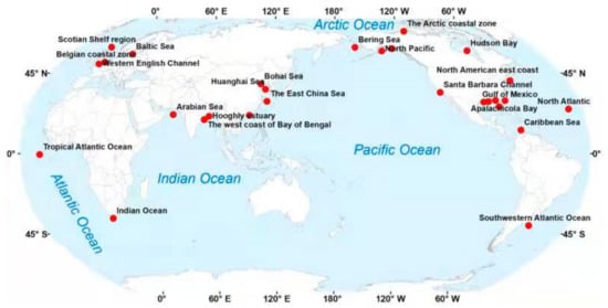
Figure 41.
Locations of published works on remote sensing of the surface
p
CO
2
in sea and coastal waters.
According to a survey of literature, the net sea–air CO2 flux of the global ocean is approximately 1.4 Pg y−1 [103][52], and this value is subjected to large uncertainty. The air–sea CO2 fluxes are different depending on the latitudinal and ecosystem diversity of the coastal ocean (particularly near-shore systems). The physical-biogeochemical distinction (including ocean-dominated margin and river-dominated ocean margin) has significant influence on the sources’/sinks’ role of coastal waters [104][53]. In addition, the marginal seas at high and temperate latitudes often act as sinks of atmospheric CO2; at subtropical and tropical regions, the marginal seas in these two climatic zones act as sources of atmospheric CO2 [105][54]. When integrating CO2 fluxes in the coastal ocean at the global scale, the diversity, latitudes, and seasonal biological effect on ecosystems should be fully considered.
2.2. Remote Sensing of pCO2 and CO2 Fluxes for Inland Waters
Typically, inland waters are characterized by the supersaturated, dissolved CO2 concentrations. However, there are huge differences in optical properties, physicochemical environments, trophic status, and circulation of materials between inland waters and ocean/coastal waters [11,13,40,41][11][13][40][41]. Some effective remote sensing algorithms and models for pCO2 in ocean/coastal waters cannot be used directly for that in inland waters. Considering the influencing factors and mechanisms of surface pCO2 in inland waters, some remote sensing algorithms for pCO2 in inland waters have been developed based on the relationship between pCO2 and the retrieved water biogeochemical and optical parameters, e.g., chromophoric dissolved organic matter (CDOM) optical property, algal productivity, and water surface temperature [41]. Earlier studies demonstrated that the temporal and spatial distributions of pCO2 in inland waters often exhibited high heterogeneity, which resulted in a large uncertainty in lake CO2 flux calculations. Satellite observations of pCO2 in inland waters could achieve a relatively high frequency and continuous, large-scale, and long-term data compared to field surveys. There are growing studies in this area in recent years despite a small number of published works. Combining with a high-resolution (25-m resolution), stream network map based on remote sensing, a Random Forest model was applied to predict the stream pCO2 with an average of 1134 μatm (range: 154–8174 μatm) in Denmark, Sweden, and Finland [106][55]. Estimations of inland waters’ CO2 emissions have been realized in relation to terrestrial net primary production, which can be obtained from a global data set based on remote sensing, such as in a temperate stream network [107][56] and in boreal lakes [13]. More recently, optical indicators generated from satellite-derived variables have been utilized to estimate pCO2 indirectly in some rivers and lakes based on the strong relationship between them, such as CDOM optical properties used in the Lower Amazon River [31] and a turbidity index used in the Swedish lakes Mälaren and Tämnaren [30]. Nevertheless, the direct application of the long-term satellite products to estimate pCO2 or dissolve CO2 in inland waters is still in its infancy. The long-term series mapping of dissolved CO2 pattern based on the remote sensing technology was conducted in Lake Taihu, China, which developed a dissolved CO2 estimation model based on MODIS-derived products. It was applied to perform the spatiotemporal distribution analysis of dissolved CO2 concentrations from 2003 to 2018 [22]. MERIS products have also been used to estimate lake pCO2 [40].
When using long-term remote sensing imagery to directly estimate the CO2 concentration or pCO2 in waters or retrieving pCO2 in water from some relevant environmental remote sensing indicators based on stable relationship [38,41[38][41][50],101], it should be noted that the retrieved CO2 concentration or pCO2 values are the instantaneous value at the satellite transit time. The previous studies showed some pronounced changes in the CO2 concentration over a day and seasons [15,22,52][15][22][57]. To achieve the transformation of retrieved pCO2 values from an instant to hours/days, some researchers have established the relationship between instantaneous lake CO2 concentration/pCO2 at the regular satellite flyover and the daily/weekly mean value [15,22,45][15][22][58] by using the satellite estimation results to extrapolate the daily/weekly CO2 mean values. In addition, combined with the in situ measured values of the diurnal pCO2 variation and seasonal pCO2 variation in a lake, we could realize the conversion of the daily value to the seasonal mean value of the lake’s CO2 through cross verification between different sensors with different time resolutions. More observations and additional efforts would be needed to achieve them in the further studies.
In fact, researchers have a full understanding of biogeochemical mechanism of CO2 generation and consumption in inland waters. Most of the determining and influence factors of pCO2 or dissolved CO2 in different inland waters have been elucidated. Some of these factors can be derived from satellite data, e.g., lake surface temperature, chlorophyll-a concentration, latitude, dissolved organic carbon (DOC), and solar radiation absorption. Therefore, in principle, it is possible to identify the spatiotemporal distribution of pCO2 in a specific lake or river using the satellite-derived variables and realize the long-term estimations. However, the accuracy and universality of the prediction models should be developed and evaluated as a priority in the large-scale estimation. Nevertheless, it is known that the relationships in the prediction models can vary among different lakes and lake regions, which is the current challenge of the pCO2 remote sensing in inland waters [22,40,41,45,47,100,101,108,109][22][40][41][58][59][49][50][60][61]. Due to the great influence of outside source input, the geochemical processes of inland lakes can show strong spatial heterogeneity, and the influence factors of the pCO2 in surface water are often coupled together. This leads to the unstable, non-universal relationship between pCO2 and its indicators among different lakes and lake regions and the large uncertainties from such extrapolations. Consequently, the development of the inverse models based on dissolved biogeochemical processes and the machine learning algorithm based on lots of measurement data may have better applicability over longer periods and across larger spatial scales.
References
- Cole, J.J.; Prairie, Y.T.; Caraco, N.F.; McDowell, W.H.; Tranvik, L.J.; Striegl, R.G.; Duarte, C.M.; Kortelainen, P.; Downing, J.A.; Middelburg, J.J.; et al. Plumbing the global carbon cycle: Integrating inland waters into the terrestrial carbon budget. Ecosystems 2007, 10, 171–184.
- Meybeck, M.; Vörösmarty, C. Global transfer of carbon by rivers. Glob. Chang. News 1999, 37, 18–19.
- Raymond, P.A.; Hartmann, J.; Lauerwald, R.; Sobek, S.; McDonald, C.; Hoover, M.; Butman, D.; Striegl, R.; Mayorga, E.; Humborg, C.; et al. Global carbon dioxide emissions from inland waters. Nature 2013, 503, 355–359.
- Tranvik, L.J.; Cole, J.J.; Prairie, Y.T. The study of carbon in inland waters-from isolated ecosystems to players in the global carbon cycle. Limnol. Oceanogr. Lett. 2018, 3, 41–48.
- IPCC. Global Warming of 1.5 °C. An IPCC Special Report on the Impacts of Global Warming of 1.5 °C above Pre-Industrial Levels and Related Global Greenhouse Gas Emission Pathways, in the Context of Strengthening the Global Response to the Threat of Climate Change, Sustainable Development, and Efforts to Eradicate Poverty; IPCC: Geneva, Switzerland, 2018.
- IPCC. Climate Change 2014: Synthesis Report. Contribution of Working Groups I, II and III to the Fifth Assessment Report of the Intergovernmental Panel on Climate Change; IPCC: Geneva, Switzerland, 2014; pp. 1–151.
- Yan, X.; Ma, J.; Li, Z.; Ji, M.; Xu, J.; Xu, X.; Wang, G.; Li, Y. CO2 dynamic of Lake Donghu highlights the need for long-term monitoring. Environ. Sci. Pollut. Res. Int. 2020, 28, 10967–10976.
- Bogard, M.J.; del Giorgio, P.A. The role of metabolism in modulating CO2 fluxes in boreal lakes. Glob. Biogeochem. Cycles 2016, 30, 1509–1525.
- Chmiel, H.E.; Hofmann, H.; Sobek, S.; Efremova, T.; Pasche, N. Where does the river end? Drivers of spatiotemporal variability in CO2 concentration and flux in the inflow area of a large boreal lake. Limnol. Oceanogr. 2020, 65, 1161–1174.
- Raymond, P.A.; Oh, N.-H.; Turner, R.E.; Broussard, W. Anthropogenically enhanced fluxes of water and carbon from the Mississippi River. Nature 2008, 451, 449–452.
- Ran, L.; Butman, D.E.; Battin, T.J.; Yang, X.; Tian, M.; Duvert, C.; Hartmann, J.; Geeraert, N.; Liu, S. Substantial decrease in CO2 emissions from Chinese inland waters due to global change. Nat. Commun. 2021, 12, 1730.
- Li, S.; Bush, R.T.; Santos, I.R.; Zhang, Q.; Song, K.; Mao, R.; Wen, Z.; Lu, X.X. Large greenhouse gases emissions from China’s lakes and reservoirs. Water Res. 2018, 147, 13–24.
- Hastie, A.; Lauerwald, R.; Weyhenmeyer, G.; Sobek, S.; Verpoorter, C.; Regnier, P. CO2 evasion from boreal lakes: Revised estimate, drivers of spatial variability, and future projections. Glob. Change Biol. 2018, 24, 711–728.
- Han, B.; Meng, X.; Yang, Q.; Wu, R.; Lv, S.; Li, Z.; Wang, X.; Li, Y.; Yu, L. Connections Between Daily Surface Temperature Contrast and CO2 Flux Over a Tibetan Lake: A Case Study of Ngoring Lake. J. Geophys. Res.-Atmos. 2020, 125, e2019JD032277.
- Xu, Y.J.; Xu, Z.; Yang, R. Rapid daily change in surface water pCO2 and CO2 evasion: A case study in a subtropical eutrophic lake in Southern USA. J. Hydrol. 2019, 570, 486–494.
- Yang, R.; Xu, Z.; Liu, S.; Xu, Y.J. Daily pCO(2) and CO2 flux variations in a subtropical mesotrophic shallow lake. Water Res. 2019, 153, 29–38.
- Ngochera, M.J.; Bootsma, H.A. Spatial and temporal dynamics of pCO(2) and CO2 flux in tropical Lake Malawi. Limnol. Oceanogr. 2020, 65, 1594–1607.
- Sobek, S.; Algesten, G.; Bergstrom, A.K.; Jansson, M.; Tranvik, L.J. The catchment and climate regulation of pCO(2) in boreal lakes. Glob. Chang. Biol. 2003, 9, 630–641.
- Jones, S.E.; Kratz, T.K.; Chiu, C.-Y.; McMahon, K.D. Influence of typhoons on annual CO2 flux from a subtropical, humic lake. Glob. Chang. Biol. 2009, 15, 243–254.
- Marce, R.; Obrador, B.; Morgui, J.-A.; Lluis Riera, J.; Lopez, P.; Armengol, J. Carbonate weathering as a driver of CO2 supersaturation in lakes. Nat. Geosci. 2015, 8, 107–111.
- DelSontro, T.; Beaulieu, J.J.; Downing, J.A. Greenhouse gas emissions from lakes and impoundments: Upscaling in the face of global change. Limnol. Oceanogr. Lett. 2018, 3, 64–75.
- Qi, T.; Xiao, Q.; Cao, Z.; Shen, M.; Ma, J.; Liu, D.; Duan, H. Satellite Estimation of Dissolved Carbon Dioxide Concentrations in China’s Lake Taihu. Environ. Sci. Technol. 2020, 54, 13709–13718.
- Frankignoulle, M.; Borges, A.; Biondo, R. A new design of equilibrator to monitor carbon dioxide in highly dynamic and turbid environments. Water Res. 2001, 35, 1344–1347.
- Abril, G.; Richard, S.; Guerin, F. In situ measurements of dissolved gases (CO2 and CH4) in a wide range of concentrations in a tropical reservoir using an equilibrator. Sci. Total Environ. 2006, 354, 246–251.
- Zhang, C.; Wang, C.; Ning, C.; Pang, Y. Intercomparison Study of Seawater pCO2 Measuring Instruments. Periodical Ocean Univ. China 2015, 45, 80–86.
- Reiman, J.H.; Xu, Y.J. Dissolved carbon export and CO2 outgassing from the lower Mississippi River—Implications of future river carbon fluxes. J. Hydrol. 2019, 578, 124093.
- Wen, Z.; Song, K.; Shang, Y.; Fang, C.; Li, L.; Lv, L.; Lv, X.; Chen, L. Carbon dioxide emissions from lakes and reservoirs of China: A regional estimate based on the calculated pCO2. Atmos. Environ. 2017, 170, 71–81.
- Wen, Z.; Song, K.; Zhao, Y.; Jin, X. Carbon dioxide and methane supersaturation in lakes of semi-humid/semi-arid region, Northeastern China. Atmos. Environ. 2016, 138, 65–73.
- Atilla, N.; McKinley, G.A.; Bennington, V.; Baehr, M.; Urban, N.; DeGrandpre, M.; Desai, A.R.; Wu, C. Observed variability of Lake Superior pCO(2). Limnol. Oceanogr. 2011, 56, 775–786.
- Yamamoto, K.; Sayama, T.; Apip. Impact of climate change on flood inundation in a tropical river basin in Indonesia. Prog. Earth Planet. Sci. 2021, 8, 5.
- Saurav, K.C.; Shrestha, S.; Ninsawat, S.; Chonwattana, S. Predicting flood events in Kathmandu Metropolitan City under climate change and urbanisation. J. Environ. Manag. 2021, 281, 111894.
- Takagaki, N.; Komori, S. Effects of rainfall on mass transfer across the air-water interface. J. Geophys. Res.-Ocean. 2007, 112.
- Macklin, P.A.; Suryaputra, I.G.N.A.; Maher, D.T.; Sidik, F.; Santos, I.R. Carbon dioxide dynamics in a tropical estuary over seasonal and rain-event time scales. Cont. Shelf Res. 2020, 206, 104196.
- Han, G.; Chu, X.; Xing, Q.; Li, D.; Yu, J.; Luo, Y.; Wang, G.; Mao, P.; Rafique, R. Effects of episodic flooding on the net ecosystem CO2 exchange of a supratidal wetland in the Yellow River Delta. J. Geophys. Res.-Biogeosci. 2015, 120, 1506–1520.
- Lees, K.J.; Quaife, T.; Artz, R.R.E.; Khomik, M.; Clark, J.M. Potential for using remote sensing to estimate carbon fluxes across northern peatlands—A review. Sci. Total Environ. 2018, 615, 857–874.
- Fu, Z.; Hu, L.; Chen, Z.; Zhang, F.; Shi, Z.; Hu, B.; Du, Z.; Liu, R. Estimating spatial and temporal variation in ocean surface pCO2 in the Gulf of Mexico using remote sensing and machine learning techniques. Sci. Total Environ. 2020, 745, 140965.
- Lafont, S.; Kergoat, L.; Dedieu, G.; Chevillard, A.; Karstens, U.; Kolle, O. Spatial and temporal variability of land CO2 fluxes estimated with remote sensing and analysis data over western Eurasia. Tellus Ser. B-Chem. Phys. Meteorol. 2002, 54, 820–833.
- Else, B.G.T.; Yackel, J.J.; Papakyriakou, T.N. Application of satellite remote sensing techniques for estimating air-sea CO2 fluxes in Hudson Bay, Canada during the ice-free season. Remote Sens. Environ. 2008, 112, 3550–3562.
- Song, X.; Bai, Y.; Cai, W.-J.; Chen, C.-T.A.; Pan, D.; He, X.; Zhu, Q. Remote Sensing of Sea Surface pCO(2) in the Bering Sea in Summer Based on a Mechanistic Semi-Analytical Algorithm (MeSAA). Remote Sens. 2016, 8, 558.
- Kutser, T.; Verpoorter, C.; Paavel, B.; Tranvik, L.J. Estimating lake carbon fractions from remote sensing data. Remote Sens. Environ. 2015, 157, 138–146.
- Valerio, A.d.M.; Kampel, M.; Vantrepotte, V.; Ward, N.D.; Sawakuchi, H.O.; Da Silva Less, D.F.; Neu, V.; Cunha, A.; Richey, J. Using CDOM optical properties for estimating DOC concentrations and pCO(2) in the Lower Amazon River. Opt. Express 2018, 26, A657–A677.
- Chen, S.; Hu, C.; Byrne, R.H.; Robbins, L.L.; Yang, B. Remote estimation of surface pCO(2) on the West Florida Shelf. Cont. Shelf Res. 2016, 128, 10–25.
- Olsen, A.; Trinanes, J.A.; Wanninkhof, R. Sea-air flux of CO2 in the Caribbean Sea estimated using in situ and remote sensing data. Remote Sens. Environ. 2004, 89, 309–325.
- Huang, W.-J.; Cai, W.-J.; Castelao, R.M.; Wang, Y.; Lohrenz, S.E. Effects of a wind-driven cross-shelf large river plume on biological production and CO2 uptake on the Gulf of Mexico during spring. Limnol. Oceanogr. 2013, 58, 1727–1735.
- Robbins, L.L.; Daly, K.L.; Barbero, L.; Wanninkhof, R.; He, R.; Zong, H.; Lisle, J.T.; Cai, W.J.; Smith, C.G. Spatial and Temporal Variability of pCO(2), Carbon Fluxes, and Saturation State on the West Florida Shelf. J. Geophys. Res.-Ocean. 2018, 123, 6174–6188.
- Chen, S.; Hu, C.; Cai, W.-J.; Yang, B. Estimating surface pCO(2) in the northern Gulf of Mexico: Which remote sensing model to use? Cont. Shelf Res. 2017, 151, 94–110.
- Chen, S.; Hu, C.; Barnes, B.B.; Wanninkhof, R.; Cai, W.-J.; Barbero, L.; Pierrot, D. A machine learning approach to estimate surface ocean pCO2 from satellite measurements. Remote Sens. Environ. 2019, 228, 203–226.
- Lu, H.; Bai, Y.; Chen, X.; Gong, F.; Zhu, Q.; Wang, D. Satellite remote sensing of the aquatic pCO(2) in the basin of the South China Sea. In Proceedings of the Remote Sensing of the Ocean, Sea Ice, Coastal Waters, and Large Water Regions 2017, Warsaw, Poland, 11–14 September 2017; Volume 10422.
- Bai, Y.; Cai, W.-J.; He, X.; Zhai, W.; Pan, D.; Dai, M.; Yu, P. A mechanistic semi-analytical method for remotely sensing sea surface pCO2 in river-dominated coastal oceans: A case study from the East China Sea. J. Geophys. Res. Ocean. 2015, 120, 2331–2349.
- Le, C.; Gao, Y.; Cai, W.-J.; Lehrter, J.C.; Bai, Y.; Jiang, Z.-P. Estimating summer sea surface pCO(2) on a river-dominated continental shelf using a satellite-based semi-mechanistic model. Remote Sens. Environ. 2019, 225, 115–126.
- Hales, B.; Strutton, P.G.; Saraceno, M.; Letelier, R.; Takahashi, T.; Feely, R.; Sabine, C.; Chavez, F. Satellite-based prediction of pCO2 in coastal waters of the eastern North Pacific. Prog. Oceanogr. 2012, 103, 1–15.
- Takahashi, T.; Sutherland, S.C.; Wanninkhof, R.; Sweeney, C.; Feely, R.A.; Chipman, D.W.; Hales, B.; Friederich, G.; Chavez, F.; Sabine, C.; et al. Climatological mean and decadal change in surface ocean pCO(2), and net sea-air CO2 flux over the global oceans. Deep-Sea Res. Part II-Top. Stud. Oceanogr. 2009, 56, 554–577.
- Dai, M.; Cao, Z.; Guo, X.; Zhai, W.; Liu, Z.; Yin, Z.; Xu, Y.; Gan, J.; Hu, J.; Du, C. Why are some marginal seas sources of atmospheric CO2? Geophys. Res. Lett. 2013, 40, 2154–2158.
- Borges, A.V.; Delille, B.; Frankignoulle, M. Budgeting sinks and sources of CO2 in the coastal ocean: Diversity of ecosystems counts. Geophys. Res. Lett. 2005, 32, 422.
- Martinsen, K.T.; Kragh, T.; Sand-Jensen, K. Carbon Dioxide Partial Pressure and Emission Throughout the Scandinavian Stream Network. Glob. Biogeochem. Cycles 2020, 34, 14.
- Magin, K.; Somlai-Haase, C.; Schaefer, R.B.; Lorke, A. Regional-scale lateral carbon transport and CO2 evasion in temperate stream catchments. Biogeosciences 2017, 14, 5003–5014.
- Yang, L.-B.; Li, X.-Y.; Yan, W.-J.; Ma, P.; Wang, J.-N. CH4 Concentrations and Emissions from Three Rivers in the Chaohu Lake Watershed in Southeast China. J. Integr. Agric. 2012, 11, 665–673.
- Morales-Pineda, M.; Cozar, A.; Laiz, I.; Ubeda, B.; Galvez, J.A. Daily, biweekly, and seasonal temporal scales of pCO(2) variability in two stratified Mediterranean reservoirs. J. Geophys. Res.-Biogeosci. 2014, 119, 509–520.
- Ouyang, Z.; Shao, C.; Chu, H.; Becker, R.; Bridgeman, T.; Stepien, C.A.; John, R.; Chen, J. The Effect of Algal Blooms on Carbon Emissions in Western Lake Erie: An Integration of Remote Sensing and Eddy Covariance Measurements. Remote Sens. 2017, 9, 44.
- Valerio, A.M.; Kampel, M.; Ward, N.D.; Sawakuchi, H.O.; Cunha, A.C.; Richey, J.E. CO2 partial pressure and fluxes in the Amazon River plume using in situ and remote sensing data. Cont. Shelf Res. 2021, 215, 104348.
- Yu, X.; Wang, Y.; Liu, X.; Liu, X. Remote sensing estimation of carbon fractions in the Chinese Yellow River estuary. Mar. Georesources Geotechnol. 2018, 36, 202–210.
More