Your browser does not fully support modern features. Please upgrade for a smoother experience.
Please note this is a comparison between Version 1 by Norma Camilla Baratta and Version 4 by Bruce Ren.
The Kofun period of the history of Japan—between the 3rd and the 7th century AD—bears its name from the construction of huge, earth mound tombs called Kofun. Among them, the largest have a keyhole shape and are attributed to the first, semi-legendary emperors. The study of the orientation of ancient tombs is usually a powerful tool to better understand the cognitive aspects of religion and power in ancient societies. This study has never been carried out in Japan due to the very large number of Kofun and to the fact that access to the perimeter is usually forbidden.
- Archaeoastronomy
- Japanese tombs
- Kofun orientation
1. Introduction
TIn the researcherspresent paper, we will be concerned with the Kofun (275–600 AD ca.) period of the history of Japan, which bears its name from the construction of thousands of earth mound tombs, some of which are among the largest monuments ever built on planet Earth [1]. There are no written sources about these tombs; excavations are rare and limited to the smaller ones, since the largest ones are considered the tombs of the first (semi-legendary) emperors and, as such, are strictly protected by law. Protection extends also to the exterior: many monuments are fenced and no permission to enter the perimeter is granted, so that it is impossible even to obtain precise measures of size or height. Furthermore, their astonishing number (a complete list is lacking, but those still visible today are many hundreds, and the total original number is estimated in the thousands) discourages every on-field investigation. It is thus natural to investigate them using simple but powerful tools of satellite imagery, in a manner similar to that recently followed for the Chinese imperial tombs complexes [2]. Our aim is to gain a better understanding of the cognitive aspects of the Kofun and, in particular, in the present paper, thwe researchers investigate the possible relationships of these tombs with the sky, an aim also motivated by a recent work in which orientation along the winter solstice sunrise/summer solstice sunset line has been found to occur in the hugest Kofun ever built, the Daisen [3].
As far as thwe researchers know, this is the first comprehensive attempt at analyzing the orientation of these fascinating monuments. To approach the problem in a reasonable but manageable way, the researcherswe constructed two databases. One includes all the Kofun whose entrance corridor has been measured, the other includes virtually all the measurable keyhole Kofun, which, as the researchers shwe shall see, are the most characteristic and important from a historical point of view. In particular, the dimensions of these tombs have a large variability, but about 33% stand out for their length, which exceeds 150 m, and one of them is as large as 486 m in length. These are usually considered the tombs of the first emperors of Japan. The database (Appendix A) includes all these huge monuments. Furthermore, thwe researchers measured all the recognizable elements of the five existing concentrations of Kofun (called clusters), among which are all the monuments recently included in the unique UNESCO site, the first ever to be devoted to the Kofun tombs (inscribed 2019)—the Mozu-Furuichi Kofun Group.
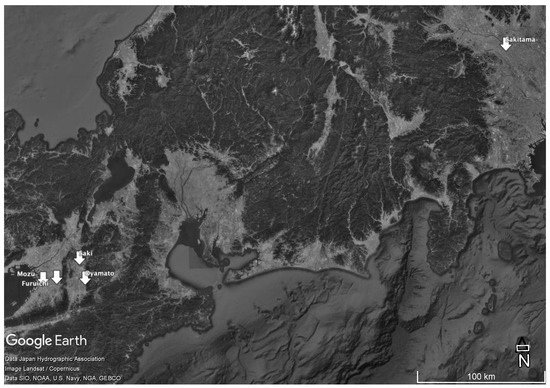
The locations of the sites under study are reported in the map of Figure 1.
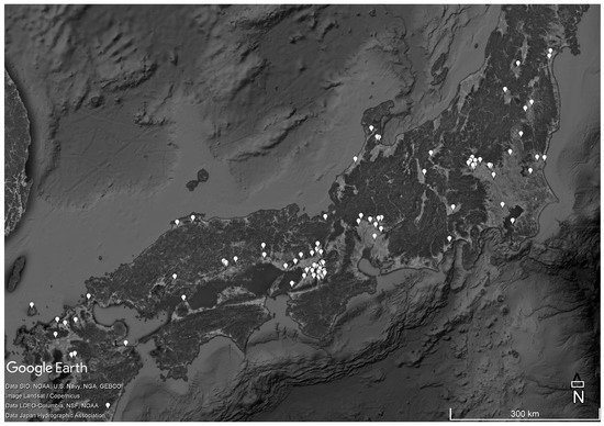
Figure 1.
Locations of the sites considered in this study (image courtesy Google Earth Pro, edited by the authors).
2. The Orientation of the Kofun Tombs
2.1. The Orientation of the Kofun Access Corridors
In 1897, William Gowland made a thorough survey of many Kofun of different shapes, measuring the azimuths of their access corridors [4]. Today, the same measures would be impossible to obtain, due to the mentioned difficulties of access to the monuments and to the fact that many of them have been damaged; therefore, thwe researchers decided to make use of Gowland’s data. Among these data, only a small number (around 10%) refer to keyhole Kofun, so the researchers we treat the keyhole phenomenon with a direct approach in the next section.
To check the reliability of the data set, thwe researchers managed to identify the largest possible number of Kofun whose entrance (or entire corridor, in case the covering earthen mound is no longer extant) is visible on satellite images. Then, the researchers cwe compared our measures to Gowland’s ones. The comparison turned out to be always very good (within half a degree); therefore, the researchers are we are confident that the data set is reliable. The data set contains Kofun of any shape; however, chronologically, the corridors (as opposed to the pit) started between the end of the 4th and the beginning of the 5th century, so the data mostly cover the middle and the late Kofun period. Comprehensively, the researchers we found reliable data for 127 mounds, a number which allows a reasonably clear analysis without resorting to sophisticated statistical tools.
Actually, it is immediately clear that the distribution is not random (Figure 2 and Figure 3). The distribution is indeed peaked at due south, with 84% of the mounds presenting an alignment included between 125 and 235 degrees, to be compared with the 31% which would compete to a sector of less than 1/3 of a circle (110°) in a uniform distribution.
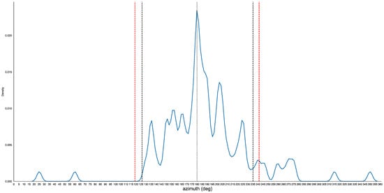
Figure 2. Kernel distribution of the azimuths of Kofun access corridors. The dashed lines indicate the azimuths of the rising/setting of the Sun at the winter solstice (red lines) and of the Moon at the major southern standstill (black lines).
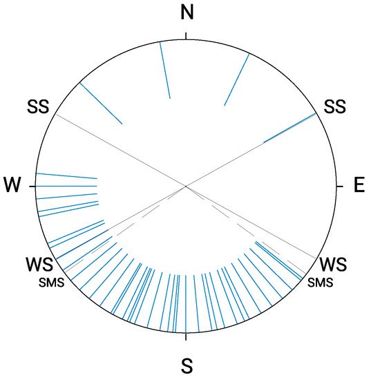
Figure 3. Orientation diagram of Kofun access corridors. The azimuths of the Sun rising/setting at the winter solstice (WS) and those of the Moon at the southern major standstill (SMS) are marked.
Taking the latitude of Osaka as a reference (and a flat horizon), the azimuths of the rising/setting of the Sun at the winter solstice are about 118–242 degrees. Therefore, the vast majority of the Kofun access corridors are orientated to a sector of the sky in which the Sun shines every day (climbing or descending) with a marked preference for culmination at due south (comparable situations occur for instance for the megalithic tombs of Europe [5]).
According to these data, a willing orientation of the Kofun’s corridors to solar exposure is virtually certain. However, analyzing the data more carefully, a more intriguing scenario appears, which leads to a more complex interpretation. As is well known, due to the precessional cycle of the lunar nodes (the points where the lunar orbit intersects the ecliptic), the maximum (and minimum) declination of the Moon is reached every 18.6 years. These declinations are +/−28.5°, and, at fixed latitude, correspond to azimuths which are always smaller/greater to those of the Sun at the summer/winter solstice. This means that orienting a building within the arc of azimuths of the Moon at the southern standstill (the minimum possible declination) assures both illumination by the Sun every day and illumination by every full Moon (the full Moon nearest to the summer solstice, in particular, will always be the one rising closer to the maximum azimuth, although the true standstill can be reached by the Moon in any of its phases). The azimuths of the Moon at the southern standstill are, at the latitude of Osaka, 126–234° (thwe researchers are are neglecting here a small variation due to the slow change of the obliquity of the Ecliptic); therefore, the vast majority of the Kofun corridors’ entrances are illuminated by the Sun every day and by every full Moon.
As thwe researchers will discuss in the final section, there are some hints coming from the Japanese traditions that combined solar–lunar exposure might be the correct interpretation for these orientations.
2.2. The Orientation of the Keyhole Kofun
ThWe researchers now concentrate on the keyhole Kofun which, as mentioned, enlist the largest royal tombs of Japan, and are poorly represented in the Gowland database. To define the orientation of a keyhole Kofun the researchers cwe could use the azimuth of its axis from the baseline to the round part. However, more suitable information is the azimuth of the baseline itself, since it is usually parallel to the direction of the entrance corridor, whenever present. The researchers hWe have thus measured the baseline azimuths of as many keyholes Kofun as possible; in order to define them uniquely, the researchers we used the following convention: the researchers awe assigned a measure of 90° to a baseline which is oriented east–west, and the round part of the keyhole is located to the north of the baseline.
To study the orientations, a database has been collected through satellite imagery. To construct the database, using a list of the existing Kofun would have been optimal, but such a list has never been compiled. Therefore, thwe researchers resorted to collecting information from different sources (articles, official websites of prefectures and local municipalities, UNESCO lists of protected sites). In this way, the researchers hwe have been able to list 158 localizable keyhole Kofun, among which, all the largest built Kofun (length of the axis greater than 200 m) are included. In compiling the database, the researchers rewe registered the geographic coordinates, the orientation, and short notes of information. These include length of the baseline, length of the symmetry axis, significant geo-morphological elements, such as presence of water, and position with respect to the mountain ranges (whether in the plains, by a slope, or on reliefs). These data might be useful for a deeper future analysis. Finally, the researcherswe registered the membership to a cluster and the “role” of the Kofun in the cluster: certainly principal, probably principal, or satellite.
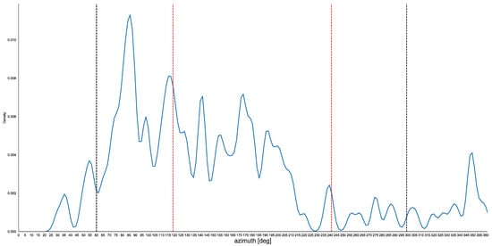
To investigate orientations, it is preferable to use only the data of the keyholes, which are either isolated or (with good certainty) principal, because there are cases in which it was the orientation of the main Kofun of a cluster which governed those of the satellites (see also next section). However, since few satellites are measurable, this reduces our data slightly, to 151, a number which is still sufficient to see whether a custom of orientation is present (Figure 4 and Figure 5).
Figure 4. Kernel distribution of the azimuths of keyhole Kofun baselines. The azimuths of the Sun rising/setting at the summer (black lines)/winter (red lines) solstice (SS, WS) are reported.
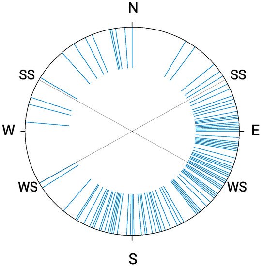
Figure 5. Orientation diagram of the azimuths of keyhole Kofun baselines. The azimuths of the Sun rising/setting at the summer/winter solstice (SS, WS) are reported.
The majority of the orientations of these Kofun (82% or 130 Kofun) is located in an arc of about half of a circle. Comparing our distribution with 100,000 random distributions (generated in Python with random.sample), thwe researchers cconfirmed that the alignments of the Kofun are not random.
It should be noted that distributions in azimuths on a circle, like the one studied here, can be compared with simple uniform distributions—that is, the null hypothesis in which each azimuth value is equally likely to be picked, since each azimuth value is an independent “box”—this would not be true in case of declination data, which, in the null hypothesis, would accumulate at the extreme and directional (circular) statistics would be needed [6][7].
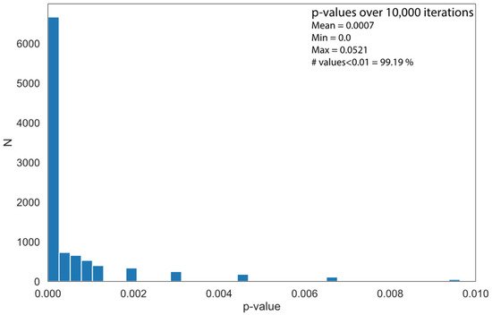
The resulting p-value (mean 7 × 10⁻⁴) is far below the usually accepted significance value of 0.05; therefore, the test fully refutes the null hypothesis of random orientation, confirming that the orientation was intentional (Figure 6).
Figure 6.
p
-value test results over 10,000 random distributions.
Proving that the orientation was intentional of course does not necessarily imply that it was astronomical. However, the arc comprising the vast majority of the azimuths is located roughly between summer solstice sunrise (az. 62) and winter solstice sunset (az. 242). This arc thus includes the arc of orientation thwe researchers hhave found before for the Kofun corridors independently from the shape, but in a sense “adds” to it the arc of the Sun rising in the whole year. Interestingly, a clear peak occurs near due east—another in correspondence of the winter solstice sunrise (the peak close to due east might a priori also correspond to orientation of the orthogonal axis to true north, if a systematic error to the west of north was present in the orientation method, for instance, if it were related to the western elongation of a circumpolar star).
The above discussion was based on azimuths only. Of course, a more detailed examination would require a study in terms of declinations; therefore, a measure of the horizon heights associated with each azimuth would be required. ThWe researchers ccan, however, perform a qualitative analysis of the possible effects of non-negligible horizon altitudes (for instance, nearby hills). For this aim, the effects at rising and at setting must be distinguished. At setting, the effect for the vast majority of the azimuths (see Figure 2 and Figure 4) is an increase in (negative) declination with respect to the declination corresponding to the same azimuth and zero height. ThWe researchers sesee from the orientation diagrams that, for the vast majority of the azimuths, the only sensible result may be to spread the distribution from true south towards the winter solstice sunset a bit; therefore, no qualitative change to our results would occur. At rising, the effect is again an increase in declination with respect to the declination corresponding to the same azimuth and zero height. Again, Figure 2 and Figure 4 show that the eventual effect is negligible for the corridors, since, “at worst”, a few declinations might spread towards winter solstice. In the keyhole case, the vast majority of the data would remain into the solar range of declinations, with only some azimuths close to summer solstice sunrise, which may eventually lead to a little spread of the data out of the solar range (i.e., towards declinations greater than 23.5°).
2.3. The Clusters
We are, therefore, fully confident in the robustness of the solar (or luni-solar) interpretation.
2.3. The Clusters
As far as satellite Kofun are concerned, it is interesting to analyze the data referring to each cluster, although the small number of items makes any discussion purely qualitative. In the literature there are five well-documented clusters (Figure 7).
Figure 7.
Location of the clusters (image courtesy of Google Earth).
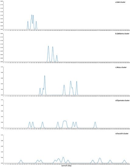
These are (in rough chronological order) Oyamato and Saki in the first half of the Kofun period, and Furuichi, Mozu, and Sakitama in the second half. ThWe researchers hhave found clear patterns of orientation in three of them, as follows:
-
In the Saki and Sakitama clusters, the orientation of the principal tomb directly governed the orientation of the others (Figure 8a,b).
-
In the Mozu cluster, the orientation of the principal tomb (the Daisen Kofun, oriented to summer solstice sunset) governed that of the others in the sense that a part is orientated in the same way and another part are orientated (almost) orthogonally (azimuths greater of about 90°) (Figure 8c).
-
No pattern is discernible in the orientations of the Oyamato and Furuichi clusters; although, at least in the first case, topographical reasons connected to the mountain range of Mount Miwa may have played a role (Figure 8d,e).
Figure 8. Kernel distribution of the orientations of keyhole Kofun in the Saki (a), Sakitama (b), Mozu (c), Oyamato (d), and Furuichi (e) clusters.
At the level of observation, thwe researchers notice that these patterns may correspond to political–religious patterns, which differentiate the corresponding periods/areas and might be enlightened by future historical research.
References
- Mizoguchi, K. An Archaeological History of Japan; University of Pennsylvania Press: Philadelphia, PA, USA, 2002.
- Magli, G. Astronomy and Feng Shui in the projects of the Tang, Ming and Qing royal mausoleums: A satellite imagery approach. Archaeol. Res. Asia 2018, 17, 98–108.
- Magli, G. The Orientation of the Daisen Kofun. Available online: https://papers.ssrn.com/sol3/papers.cfm?abstract_id=3604011 (accessed on 18 May 2020).
- Gowland, W. XX.—The Dolmens and Burial Mounds in Japan. Archaeologia 1897, 55, 439–524.
- Hoskin, M. Tombs, Temples, and Their Orientations. A New Perspective on Mediterranean Prehistory; Ocarina Books: Bognor Regis, UK, 2001.
- González-García, C.; Šprajc, I. Astronomical significance of architectural orientations in the Maya Lowlands: A statistical approach. J. Archaeol. Sci. Rep. 2016, 9, 191–202.
- Silva, F. A probabilistic framework and significance test for the analysis of structural orientations in skyscape archaeology. J. Archaeol. Sci. 2020, 118, 105138.
More