This study visualizes and quantifies extant publications of rural landscape research (RLR) in Web of Science using CiteSpace for a wide range of research topics, from a multi-angle analysis of the overall research profile, while providing a method and approach for quantitative analysis of massive literature data. First, it presents the number of papers published, subject distribution, author network, the fundamental condition of countries, and research organizations involved in RLR through network analysis. Second, it identifies the high-frequency and high betweenness-centrality values of the basic research content of RLR through keyword co-occurrence analysis and keyword time zones. Finally, it identifies research fronts and trending topics of RLR in the decade from 2009 to 2018 by using co-citation clustering, and noun-term burst detection. The results show that basic research content involves protection, management, biodiversity, and land use. Five clearer research frontier pathways and top 20 research trending topics are extracted to show diversified research branch development. All this provides the reader with a general preliminary grasp of RLR, showing that cooperation and analysis involving multiple disciplines, specialties, and angles will become a dominant trend in the field.
- bibliometrics
- mapping knowledge domains
- rural landscape research
- frontier paths
- trending topics
1. Overview of Rural Landscape Research
1.1. Number of Papers Published
Since 1936, the amount of research has tended to increase year by year, with particularly high growth rates in 2006, 2009, 2015, and 2017. The growth rate peaked in 2017, and the largest number of articles (782) was published in 2018.
1.2. Distribution of Research Disciplines
The subject distribution status of RLR can be obtained by visualizing the results through the ‘Category’ option in CiteSpace. After simplifying and merging the data with the same subject, 139 nodes and 209 lines were extracted, and betweenness-centrality analysis was performed (Figure 1). This analysis showed that RLR is involved in more than one hundred disciplines. In five of these disciplines, the number of articles published exceeded 1000, including the disciplines of environmental sciences and ecology, ecology, environmental sciences, environmental studies, and geography. The betweenness-centrality value exceeded 0.1 in 11 disciplines (e.g., engineering, social sciences and interdisciplinary, agriculture, and environmental sciences and ecology). Although there were few publications in some disciplines (e.g., psychology, social sciences and interdisciplinary), the betweenness-centrality value was relatively high, reflecting that these disciplines play a pivotal role in the construction of the interdisciplinary collaboration and research system. In addition, according to the intensity value of the connection lines, environmental sciences and ecology has a strong connection with similar fields such as environmental studies, and also has close interdisciplinary relationships with other subjects, such as geography, urban study, public administration, agriculture, and social sciences, among others.
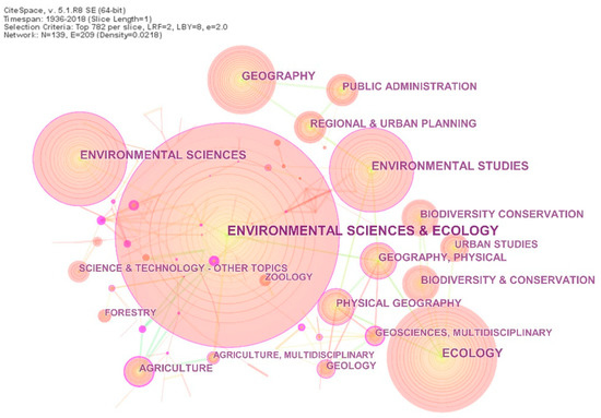
Figure 1. Distribution of main research disciplines.
1.3. Authors of Core Articles
In the mapping knowledge domain of author cooperation in CiteSpace, there were 1058 nodes and 1408 lines that connected the nodes. Among them, 18 authors published more than ten articles. Salvati, who published the largest number of articles, had 47 articles included in the WoS database. Moreover, there were relatively dominant academic associations. Among them were Verburg, Plieninger, Fischer, Hartel, Hanspach, and some other authors (Figure 2). Their academic backgrounds include agriculture, environmental geography, ecology, agricultural sociology, landscape ecology, etc., showing the interdisciplinary relationships.
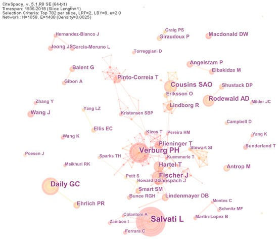
Figure 2. Authors network of core articles.
1.4. Countries of Articles’ Origin
The cooperation network of countries showed 110 nodes and 909 lines connecting the nodes, among which, scholars in the United States published the largest number of articles (1958). A total of 12 countries published more than 200 articles. The betweenness centrality in France, New Zealand, Switzerland, the United States, Britain, Germany, and Belgium, was more than 0.1 (Figure 3). Most of the high volume of publications and high betweenness-centrality values were found in European countries, likely due to the similar natural and geographical environment that makes European countries form strong research links. European countries’ alliances and organizations on landscape research, as well as the formulation and promulgation of some conventions and policies, have important significance for the research and development of rural landscapes and have been widely used for reference. These include the European Landscape Convention of the Council of Europe, which promotes the protection, management, and planning of the landscapes and organizes international co-operation on landscape issues.
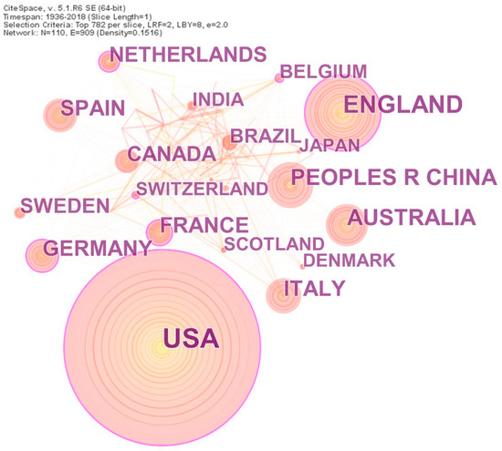
Figure 3. Main countries of articles’ origin.
1.5. Research Organizations
CiteSpace showed 930 nodes and 3536 lines for the organizations where research was conducted. Among these, 11 organizations published more than 60 articles in the field. Chinese Academy of Sciences had the largest number of papers published, with 138 articles in the WoS database. Three research organizations, Chinese Academy of Sciences, University of Copenhagen, and University of Cambridge, had a betweenness-centrality value over 0.1, reflecting their importance and influence in the field (Figure 4). Comparative analysis showed a direct correlation between the number of papers published by researchers at specific organizations and the number of papers published in countries where those organizations were located. For example, researchers at the University of Wisconsin, Ohio State University and Stanford University in the United States published numerous papers on RLR, which contributed to the high number of papers published in the United States.
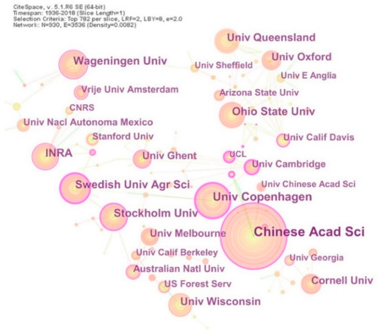
Figure 4. Main research organizations.
2. Themes and Fields of Rural Landscape Research
According to the results of the keywords co-occurrence analysis, by eliminating the retrieval terms, the four keywords that have been used over a long time and have high-frequency (Frequency over 700) were ‘protection’ (1034), ‘biodiversity’ (839), ‘management’ (829), and ‘land use’ (707),which can thus be considered the major fields and basic contents of RLR (Figure 5). The keyword time zone map shows these four high-frequency keywords began to appear in 1984, probably because the keywords of the early literature were not included in WoS. Of these, land use, protection, and management have a relatively high betweenness-centrality value and are media keywords for multidisciplinary and interdisciplinary studies of rural landscapes (Figure 6). In addition, the frequency of co-occurrence of key words such as urbanization, agriculture, forests, and diversity all exceeded 400. Among them, urbanization and agriculture have relatively high betweenness-centrality values. In each subject area, we selected representative articles based on the frequency of citations from high to low and more closely related to the topic and analyzed the research contents.
The rural landscape takes the ecological, environmental, and historical and cultural aspects as protection objects[1][2][3] [16–18], and the local residents as the main protection subject[4][5][6][7] [19–22]. Research on rural landscape protection has appeared early, frequently, and with strong intermediary centrality, which is the ultimate goal and purpose of the RLR. Rural landscape management aims to plan and assess land use and human activities in rural areas, coordinate with various stakeholders and interest groups, maintain landscapes at appropriate spatial scales and time periods, and ensure the economic, social, and environmental sustainability of ecosystems and resources[8] [23]. Rural landscape management is the avenue for the application of many RLR results[8][9][10][11][12][13][14] [23–29]. Land use is the carrier and substrate of rural landscape, which leads to changes in the natural and human environment of rural landscapes under the interaction of different time, space, and intensities[15][16][17][18][19][20][21] [30–36]. The biodiversity and ecological functions of rural landscapes have also been the focus of scholars[22][23] [37,38]. As the most common form of rural landscape, agricultural landscapes with diverse structures are key habitats in stimulating and protecting biodiversity[24][25][26][27] [39–42].
In addition, these keywords do not always exist independently, but often present a related research status, For example: the impact of changes in agricultural models on traditional land use[28][29][30][31] [43–46] and the protection of different agricultural substrates on biodiversity[32][33][34][35] [47–50]. Negative correlations were found between increased land use intensity and heterogeneity of rural landscapes, habitat diversity, species richness, and biodiversity[23][25][36][37] [38,40,51,52]. The dynamic changes of urbanization have led to new patterns in rural landscapes[38][39] [53,54]. Landscape indicators in landscape ecology are often combined with urban gradient analysis and are widely used to study changes in rural landscape patterns[36][40][41][42][43][44][45][46][47][48] [51,55–63].
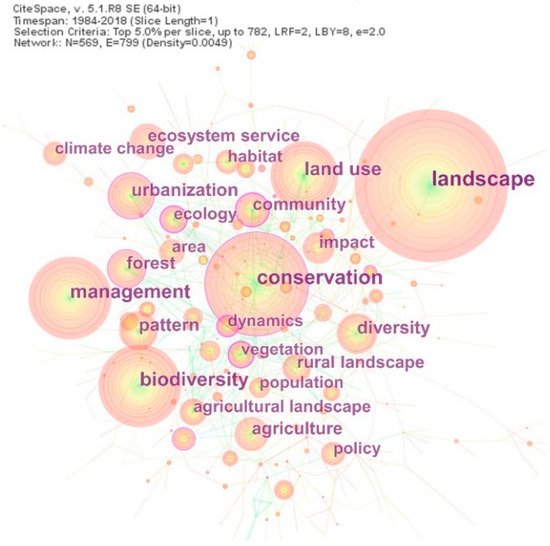
Figure 5. Keyword co-occurrence analysis (due to the clarity and visualization, the picture only shows the keywords of the top five cited articles in each year).

Figure 6. Time zone chart of keywords (Shows the distribution of key words and their frequencies over time from 1977 to 2018, the time slice set to every two years. Each circle in the figure represents a keyword that first appears in the analyzed data set and is fixed in the first year. If the keyword appears in a later year, it will be superimposed at the first occurrence).
3. Frontiers and Trending Topics of Rural Landscape Research in the Past Decade
3.1. Frontiers of Rural Landscape Research
The co-citation clustering view of RLR was generated with cited references as node types, and the maximum displays in each time slice are the total number of citations. Q = 0.6401 represents the significant modularity of the clustering network. S = 0.5292 represents a relatively high homogeneity of the network and ideal results of clustering. In Figure 7, there are a total of 29 clusters. In order to maintain the clarity of clusters, only five of them with the largest number of references and the highest homogeneity were highlighted and sorted out, and then the highly related noun terms derived from these clusters were summarized (Table 1). The frequently cited references in the clusters were read intensively. Next, according to the time zone chart of keyword co-occurrence, the branches of various studies were derived from the interpretation of basic thematic research on rural landscapes in the past ten years. The cutting-edge frontiers of the rural landscape were thereby determined. We found the following five main research pathways and sorted out the core contents.
Table 1. High-frequency co-words of co-citation clustering (top 5).
|
Cluster ID |
Size |
Silhouette |
Mean (Year) |
Core Noun Terms |
|
0 |
1304 |
0.53 |
2008 |
changing rural landscape; awareness–action gap; political ecology; rural landholders; collective occupational identity |
|
1 |
903 |
0.601 |
2012 |
ecosystem service; livestock production area; cultural landscape; collective scientific assessment; landscape planning |
|
2 |
887 |
0.594 |
2006 |
urbanization; rural housing; landscape dynamics; public–private interface; invasive exotic plant species richness |
|
3 |
785 |
0.546 |
2010 |
conservation; agrobiodiversity management; tropical amphibian; genetic structure; mechanistic insight |
|
4 |
676 |
0.576 |
2010 |
agricultural land abandonment; driving force; environmental change; land use change; regional scale |
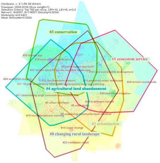
Figure 7. Clustering of co-citation references (the five clusters are highlighted by using different color edges and noun terms).
- Climate change—Landscape recognition and functional demand—Rural landscape transformation research path.
The reasons for the transformation of rural landscapes come from the natural environment, especially due to the rising climate problems in recent years. Climate change will lead to a shift in the current agricultural system[49][50] [64,65]. Such transformational adaptation encourages the understanding of the current situation of agriculture in rural landscapes and motivates the adaptation of an agricultural system to landscapes; rural communities; and social, political, and cultural environments. Another aspect stems from changes in nature, aesthetics, and lifestyle over the past decade. New land administrators and aborigines understand and manage landscapes in different ways, leading to different effects on the transformation of the functions of rural landscapes[51][52] [66,67]. Areas that were mainly used for productive agriculture have received increasing attention. Rural landscape sites are being transformed into multi-functional villages in pursuit of the unification of production, landscape protection, and consumption value[53][54] [68,69].
- Ecosystem services—Quantitative evaluation—Landscape planning—Scientific management of a rural cultural landscape research path.
In recent years, a strong trend has been research into the perception and assessment of ecosystem services in rural landscapes[55][56][57] [70–72]. Its applications concentrate mainly on the quantification of the values of ecosystem services that guide agricultural production[58] [73], the management of community forestry[59] [74], ecological transformation of agriculture[60] [75], and the effective management of the rural cultural landscape[61][62] [76,77]. The recognition and evaluation of the value of rural landscape services are oriented to management and development to provide a more scientific basis for supporting and guiding land use and landscape planning and decision-making[55][56][63] [70,71,78].
- 3. The research path focusing on synergic relationship between urbanization, biodiversity, and rural landscape.
Although the negative influence of urbanization on rural landscapes and biodiversity has been widely recognized, some studies found that landscape connectivity between urban and rural areas and landscapes with moderate urbanization could provide favorable habitats for some species[43][64][65] [58,79,80]. Between 2010 and 2014, many scholars gradually shifted their concerns to strategies for the coordinated development of urbanization, rural landscape, and biodiversity. For example, they found that the species diversity of semi-aquatic turtles could be enhanced by increasing the connectivity and quantity of green spaces in suburban landscapes[66] [81], and population urbanization’s mediating role helps to strengthen the connectivity of rural landscapes, thus promoting the spread of seeds[67] [82].
- Biodiversity management—Establishment of agricultural system—Rural landscape protection research path.
The expansion of agricultural land will affect the migration and distribution of organisms as well as gene flow in forests, while the agricultural intensification with high input is accompanied by a loss of biodiversity in rural landscapes[18][68] [33,83]. Therefore, promoting the balance between agricultural production in the agricultural system and biodiversity protection in rural landscapes is a key issue. Studies show that the establishment of a mixed agricultural and forestry system can enhance agricultural sustainability and biodiversity, while protecting landscapes that are culturally and aesthetically significant[69][70][71][72] [84–87]. Evaluation of the economic benefits of agricultural intensification and biodiversity in rural landscapes can provide a reference for the rationality of agricultural system interventions. Systematic agricultural landscape protection planning can achieve a balance between food security, landscape development, and biodiversity in rural landscapes[68] [83].
- Environmental driving—Land use change—Regional scale—Rural landscape evolution research path.
The main driving forces for the evolution of rural landscapes include climate change, social and economic urbanization, among others[73][74][75] [88–90]. A comprehensive assessment of the evolution of rural landscapes will be conducive to environmental management and spatial planning of landscapes, which is composed of both the changes in land use and the composition and patterns of landscapes[73][76] [88,91]. In recent years, scholars have been more inclined to study the evolution of rural landscapes from a regional scale. We can find the research scopes of different scales, such as the Mediterranean mountain, southern–eastern Europe, southern Italy, and Iberia range, among the nouns in the cluster set analysis, showing research trends across administrative boundaries, regions, and countries. Representative studies include, van der Zanden et al.[77] [92] who constructed a density map of linear landscape elements with a Europe-wide coverage, better reflecting the landscape structure in the environmental evaluation at a regional scale in accordance with areal typology. Verburg et al.[78] [93] simulated land-use patterns in Europe as a whole on the basis of changes in the context of population, economics, and policy, determining the main trajectory of agricultural abandonment and expansion. Barreiro-Lostres et al.[79] [94] studied the long-term evolution sequence of the landscape in mountainous rural areas of the Mediterranean, focusing particularly on land degradation and soil erosion from the perspective of sustainable development.
3.2. Trending Topics in Rural Landscape Research in the Past Decade
The high-frequency words in RLR and the time map for their bursts was visualized in terms of the analysis of noun-terms burst, yielding 198 burst noun terms. Figure 8 shows 20 groups of terms with the highest frequency.
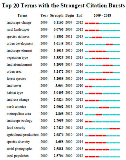
Figure 8. Top 20 high-frequency terms and their burst time ‘Terms’ represents the burst noun terms; ‘Year’ represents the starting time of the analysis (i.e., 2009, means the time span 2009–2018); ‘Strength’ represents the intensity of the burst; ‘Begin’ represents the starting year of the burst of noun terms; ‘End’ represents the end year of the burst; and the red line represents the duration of the burst.
In the period of 2009−2018, ecology-related research topics have been popular in RLR, which represents sustained frequency. In particular, research on types of vegetation in rural landscapes was a trending topic for five years.
In terms of time and content, previous studies mainly focused on rural landscape changes. The issue of landscape change under the influence of land use and land cover was a trending research topic for four years, until 2012. Since 2012, urbanization-related issues have become the main fields of research, particularly the regional study of rural urbanization and the impact of urban development and expansion on rural landscapes, as well as rapid urbanization, urban areas, and urban agriculture. With increased demand for better living conditions, rural landscape diversity and multifunction, food security, green spaces, cultural ecosystem services, and other life issues related to rural landscapes have become new focuses of research.
In these terms, the aerial photography lasted the longest, seven years to be exact. Aerial photography provides high-quality pictures and has been widely used as the basic tool for RLR. Due to the application of new tools and instruments, research into rural landscapes has focused increasingly on such data and technology.
4. Conclusions
Rural landscapes act as carriers through ecological methods and strategies to analyze biodiversity, species richness, and the behaviors and habits of species. The social forms and problems, political orientations, and institutional impacts behind the rural landscapes have always been a matter of great concern. The participation of the public, the role of farmers, the need for perceiving rural landscape characteristics from the perspective of human geography, and more integrated perspective for planning and cross-regional practice become increasingly important. The research tools, methods, and technologies used for identifying the characteristics, patterns, structures, and evolution mechanisms of rural landscapes are also constantly updated and integrated for the sake of scientific and comprehensive analyses from different angles. Rural landscapes have comprehensive, diverse, and strong connections with local natural resources, political and economic policies, social structures, and cultural awareness. Thus, rural landscapes should be discussed in the context of the various factors that drive such changes in landscapes and lead to diversified forms of research characterized by a wide coverage and complex subject systems. Therefore, the cooperation and analysis of multiple disciplines, specialties, and angles should continue into the future.
This paper used CiteSpace, a practical tool for improving our understanding of a research field, to carry out a visualization study of 7581 papers related to rural landscapes. This approach can overcome the limitations of the literature analysis of previous studies and reduce the subjectivity and inoperability of artificial screening. Through the analysis, we obtained the number of papers published, subject distribution, author network, fundamental condition of countries, and research organizations involved in RLR. The basic research content involves protection, management, biodiversity, and land use. Five clearer research frontier pathways and top 20 research trending topics were extracted. It provided a comprehensive picture for the study of rural landscapes and filled the gap in this aspect of research. Because of the complexity of the related disciplines, there were, however, some limitations, such as inadequacies in the depth and comprehensiveness of the analyses arising from limitations of the samples and the authors’ knowledge. Additionally, when applying CiteSpace to co-citation clustering, there were 29 cluster samples, except the 0–4 clusters we selected from high to low, the sample size from cluster 5–12 exceeded 100. Due to text restrictions and because some clustering content was so comprehensive that the research pathway was not obvious, no further analysis was performed. Although the path of rural landscape research frontiers is based on the clustering result, it still has a certain extent of subjectivity and needs further combing and analysis. This study only reflects the general and basic state of RLR. However, for the big data literature system and larger topics, a more scientific bibliometric analysis method and approach was introduced. Considering the popularity and complexity of this research field, it is suitable to use the thematic research areas identified in this study for further cluster analysis to find out the correlation. It can also combine the time zone chart and co-citation clustering view of RLR to screen more specific research pathways and determine the literatures that demand intensive reading to conduct further research and deeper analysis.
该出版物可以在这里找到:https://www.mdpi.com/2071-1050/12/1/66