Natural hazards are processes that serve as triggers for natural disasters. Natural hazards can be classified into six categories. Geophysical or geological hazards relate to movement in solid earth. Their examples include earthquakes and volcanic activity. Hydrological hazards relate to the movement of water and include floods, landslides, and wave action. Meteorological hazards are storms, extreme temperatures, and fog. Climatological hazards are increasingly related to climate change and include droughts and wildfires. Biological hazards are caused by exposure to living organisms and/or their toxic substances. The COVID-19 virus is an example of a biological hazard. Extraterrestrial hazards are caused by asteroids, meteoroids, and comets as they pass near earth or strike earth. In addition to local damage, they can change earth inter planetary conditions that can affect the Earth’s magnetosphere, ionosphere, and thermosphere. This entry presents an overview of origins, impacts, and management of natural disasters. It describes processes that have potential to cause natural disasters. It outlines a brief history of impacts of natural hazards on the human built environment and the common techniques adopted for natural disaster preparedness. It also lays out challenges in dealing with disasters caused by natural hazards and points to new directions in warding off the adverse impact of such disasters.
- natural hazards
- disasters
- global impacts
- disaster management
- built environment
1. Introduction
Earthquakes, floods, cyclones, storms, wildfires, volcanic eruptions, and landslides are natural processes that have sculptured the landscape of the earth for millenniums. These natural processes can cause natural disasters on interaction with human-made features such as settlements, agriculture, and infrastructure. This article begins with an overview of the various natural processes that have potential to cause natural disasters. After that, a brief history of impacts of natural hazards on the human built environment is provided, followed by a description of the common techniques adopted for natural disaster management. The chapter concludes with a review of challenges in dealing with disasters caused by natural hazards and points to new directions in building the capacity to ward off the adverse impact of natural disasters on vulnerable sections of society.
2. Natural Processes or Natural Hazards
The natural processes (or hazards) that are the triggers for natural disasters are broadly classified into six categories [1,2]. The definitions and descriptions of each hazard are as follows:
- Geophysical: This is also termed as geological hazard and originates from the solid crust of the Earth. The events associated with this hazard include earthquakes, volcanic activity, and dry mass movement.
- Hydrological: This hazard is associated with the occurrence, movement, and distribution of fresh and saltwater over or beneath the Earth’s surface. The events created by this hazard include floods, landslides, and scour and wave action.
- Meteorological: This hazard constitutes short-lived events having a time-span of minutes to a few days and are caused by micro- (<1 km) to meso-scale (2~2000 km) atmospheric conditions that can be exacerbated by global climate change. Convective storms (or tornadoes), extra-tropical storms (occurring in the middle, i.e., 30° to 60° latitude), tropical storms (occurring up to 30° latitude), fog, and sudden extreme temperature variation are included in this category of hazard.
- Climatological: A hazard linked with variability in climate over a broad time-span ranging from intra-season to multi-decade at a meso- to macro- (>2000 km) scale. Droughts, wildfires, glacial movement, and glacial lake outburst are some of the events associated with this hazard.
- Biological: A hazard originating from a biological substance, e.g., venom, mold, or a vector carrying disease-causing organisms, exposure to which poses a threat to other living beings or humans. Locust swarms, algal blooms, venomous wildlife infestation, and vector-borne diseases such as plague, malaria, dengue, and COVID-19 are some examples of this hazard.
- Extraterrestrial: A hazard originating outside the Earth’s atmosphere that may be caused by residues of asteroids, meteorites, comets, or human space debris, when these enter Earth’s atmosphere, or the impact caused by these objects on Earth’s surface. This hazard may also be caused by interplanetary conditions such as solar flares that can cause disruption in the Earth’s magnetosphere, thermosphere, or ionosphere.
Figure 1 depicts these categories of hazards along with main events and pertinent examples of peril/harm for each type of natural hazard. This article will explore the origin, impact, and management of natural disaster in the context of geophysical, hydrological, and climatological hazards only. These hazards were chosen in this article due to their pronounced impact on the human-built infrastructure and the socio-economic consequences posed by disasters caused by these natural hazards.
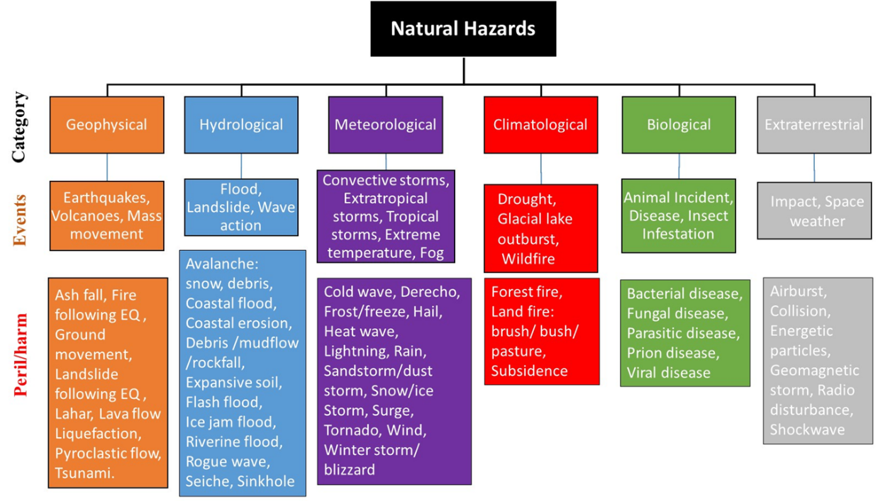 Figure 1. Classification of natural hazards with examples of events and peril/harm for each category.
3. Definitions and Terminologies
The field of natural disaster preparedness and hazard mitigation has been dynamically evolving for the past six decades. It is therefore necessary to obtain a clear understanding of various terms used in the context of natural disaster planning, preparedness, and mitigation.
3.1. Hazard
According to Cutter [3], “A hazard, in the broadest term, is a threat to people and the things they value. Hazards have a potentiality to them (they could happen), but they also include the actual impact of an event on people or places. Hazards arise from the interaction between social, technological, and natural systems”. This definition of hazard implies that the interaction between the natural and the social systems is the key element, which transforms a natural process to a hazard. It is also to be understood that ‘hazard’ by itself is harmless, as it is only a ‘threat’ that has the potential to cause harm. Therefore, Federal Emergency Management Agency (FEMA) [4] portrays hazards as “events or physical conditions that have potential to fatalities, injuries, property damage, infrastructure damage, agricultural loss, damage to the environment, interruption of business, or other types of harm or loss”. In the same vein, the United Nations International Strategy for Disaster Reduction (UNISDR) [5] defines a natural hazard as “any natural process or phenomenon that may cause loss of life, injury or other health impacts, property damage, loss of livelihoods and services, social and economic disruption or environmental damage”.
3.2. Exposure
According to the Cambridge Dictionary, exposure is “the fact of experiencing something or being affected by it because of being in a particular situation or place”. Therefore, in the context of natural disaster management, exposure refers to the inventory of elements (i.e., people, property, systems, or functions) in an area in which hazard events may occur [6,7]. Hence, if human or capital resources are not located in an area that is exposed to natural hazard(s), then there is no risk of a natural disaster. Exposure to a hazard is a necessary but not a sufficient requirement for a disaster situation to develop. For example, an asset could be exposed to a hazard but may possess sufficient capacity to withstand the hazard without damage and thus avoiding a disaster.
3.3. Vulnerability
Vulnerability refers to the susceptibility to loss of human life, physical injury, or economic loss of livelihoods and assets when exposed to hazard events [6,7]. The extent of vulnerability depends on the construction, predisposition, fragilities, inherent capacity, or weakness of the exposed elements [8].
3.4. Disaster
According to the Merriam Webster dictionary, a disaster is defined as “a sudden calamitous event bringing great damage, loss, or destruction”. Therefore, a disaster is an actual event having unfavorable consequences, unlike a hazard or risk, which is a potential threat. In the lexicon of natural disaster management community, a disaster is “a serious disruption of the functioning of a community or a society involving widespread human, material, economic or environmental losses or impacts which exceed the ability of the affected community or society to cope using its own resources” [5]. On the other hand, according to the Center for Research on the Epidemiology of Disasters (CRED) [9], a disaster is “a situation or event which overwhelms local capacity, necessitating a request to a national or international level for external assistance; an unforeseen and often sudden event that causes great damage, destruction and human suffering”.
Natural hazards have their origins in natural processes, but disasters affect a community and have social consequences that disrupt societal functioning and cause human and/or material loss. A hazardous process (event) occurring in an uninhabited region is not termed as a disaster, as it does not influence people (society) and their possessions (infrastructure). Similarly, occurrence of a hazardous process in a community that has built sufficient protection against such an event may also avoid a disaster. The following mnemonic expression eloquently describes this relationship:
|
Disaster = (Hazard + Vulnerability)/Capacity |
(1) |
The degree of exposure to a hazard and the level of vulnerability is directly related to the magnitude of a disaster, whereas disaster magnitude is inversely proportional to capacity.
3.5. Risk
The Oxford English Dictionary defines risk as “(Exposure to) the possibility of loss, injury, or other adverse or unwelcome circumstance; a chance or situation involving such a possibility”. Ansell and Wharton [10] argue: “Risk is the likelihood of an event’s occurrence multiplied by the consequences of that event, if it occurs” and can be stated as the following mnemonic:
|
Risk (R) = Hazard (H) × Vulnerability (V) |
(2) |
Risk depends on the combination of hazard, vulnerability, and exposure. Risk is the estimated impact that a hazard would have on people, services, infrastructure, and physical assets in a community. It refers to the likelihood of a hazard event becoming a disaster [7].
Wisner et al. [11] modified the relationship presented in (2) by including personal protection capacity (C) and larger scale risk mitigation measures at the societal level (M) and proposed the following mnemonic relationship between these variables:
|
R = H × [(V/C) − M] |
(3) |
It is to be noted that the expressions given by the mnemonics above are not exact mathematical relationships but are merely attempts to correlate various factors in the complex phenomenon.
4. Theories of Natural Disasters
Theories of origin of disasters have evolved over time, showing advancements in human understanding of the physical natural phenomena and their interaction with the social systems and infrastructure built by humankind [12]. An understanding of these theories is necessary for natural disaster planning, preparedness, and mitigation. Four theories of disaster are briefly reviewed in the following.
4.1. Disaster as a Retribution—An Act of God
Earliest usage, with continued acceptance in some communities, suggests that disasters are acts of God, which happen as “a divine retribution for human misdeeds and failings” [13]. A recent study found that the concept of disasters as act of God is still prevalent worldwide, and such a belief is strengthened after occurrence of a major natural disaster [14]. This fatalistic viewpoint encourages accepting the negative consequences of such event(s) as part of one’s fate and proposes that mitigation of a disaster’s impact is beyond human capacity [15]. Such fatalistic attitude could be one of the reasons for lack of disaster preparedness and adoption of better land-use planning and disaster mitigation measures in many parts of the world [16–18]. However, it is to be noted that the disaster risk management (DRM) community has moved away from this theory of disasters since the 18th century.
4.2. Disaster as a Physical Phenomenon—An Act of Nature
Progress in scientific thinking and knowledge after the Renaissance started to alter the perception of disasters from the supernatural paradigm to the natural physical realities. The Lisbon earthquake of 1755 was probably the first natural disaster that shaped the viewpoint of natural and geophysical phenomena as the agents responsible for a natural disaster [19]. According to Dynes [19]:
“Prior to that, earthquakes traditionally had been interpreted as a dramatic means of communication between gods and humans. In particular, such events previously had been explained as indicating some disturbance between earthly and heavenly spheres. The Lisbon earthquake can be identified as a turning point in human history which moved the consideration of such physical events as supernatural signals toward a more neutral or even a secular, proto-scientific causation”.
This theory of disasters became widely accepted by the early 20th century. However, the fatalism associated with disasters remained to some extent, especially for the geophysical hazards of earthquakes and volcanic activity. The only difference was the change in the causative agent, from God to Mother Nature.
This theory was instrumental in the adoption of engineering measures to ‘tame’ the natural forces that cause disasters in human settlements. The earliest examples of such attempts can be found in the building of river dams in the Middle East about 4000 years ago and earthquake-resistant dwellings in China about 2000 years ago [20]. Great strides were made in understanding the origin, physical causative mechanism, and future prediction of natural hazards (e.g., floods, earthquakes, storms, volcanic activity, etc.) after the advent of the industrial age in the late 18th century. Continuous discovery and innovation in this field continue today. This scientific knowledge was then utilized for engineering solutions that can either ‘tame’ the forces of nature (as is the case with flood control dykes, dams, embankments, and related irrigation works) or withstand the impact of brutal forces unleashed by natural phenomena such as earthquakes, windstorms, or volcanic activity by building strong, ductile, and integrated structures.
However, despite the adoptions of these engineered solutions, continuously increasing human life and economic losses stemming from natural disasters in the early half of the 20th century led to the realization that natural phenomena alone are not the only cause of disasters, and the problem cannot be adequately solved by adopting hard scientific and engineering methods alone. This led to the third theory, that disasters happen due to interaction between natural phenomena and societal systems.
4.3. Disaster as an Act of Nature–Human Interplay
Carr [21] was the first to propose that disasters occur due to the interaction between a geophysical (natural) system and a human-use system. Absence of either one will not result in a disaster. For example, a powerful earthquake happening in a remote uninhibited area is a natural hazard but will not result in a disaster.
After observing the limits of flood protection works to reduce economic losses in the USA, White [22] introduced his theory that disasters have a societal dimension, in addition to the presence of a geophysical hazard agent and the human-use system. He noted with dismay that reliance placed on the engineered solutions of flood protection works encouraged the social behavior of development of flood-prone lands for short-term economic gains. However, such actions resulted in greater economic loss after failure of the flood protection system. He advocated the ‘human ecology’ concept of Barrows [23], which calls for judicious land use planning and interconnectivity between the natural and the human systems for betterment of the society as well as the natural environment. This concept was applied to more complex interactions in subsequent studies by various authors [24–26].
A similar viewpoint of ecological design was championed by McHarg [27] for urban planning, which called for modification in the natural face of the earth for human use with due consideration to the ecology of the landscape. He argued that such planning will reduce the impact of natural hazards on human settlements. Recent studies [28,29] applied principles advocated by McHarg to the 2011 Fukushima Nuclear Power Plant disaster in Japan and to the settlements in Staten Islands subjected to Hurricane Sandy in 2012, respectively, and concluded that the economic impact of these disasters could have been considerably reduced by implementing the ecological design principles proposed by McHarg.
4.4. Disaster as a Complex Nexus of Natural-Human-Social-Economic Factors
By the late 20th century, it was clear that certain nations and segments of population were more vulnerable to the impact of natural disasters than others. Researchers and international donor agencies tried to uncover links between under-development and effects of natural disasters [30]. Two disturbing facts were noted: (1) disaster fatalities were disproportionately higher in the least developed countries (LDCs), and (2) although the absolute economic loss in LDCs was lower than that of the more developed countries (MDCs), the per capita cost of natural disasters in terms of GDP was more than 20 times higher in LDCs than in MDCs [20,31]. LDCs were noted to be caught up in a viscous circle of under-development, which was exacerbated by recurrence of natural disasters at regular intervals, which diverted the scarce and often borrowed human and infrastructure development funds to relief and reconstruction activities [32].
It is worthwhile to point out that O’Keefe et al. [33] questioned the use of the term ‘natural disasters’, as it appears to wrongly attribute disasters to nature and masks the role of decision makers responsible for underdevelopment, which is the main cause of people’s increased vulnerability to natural hazards. Recently, Chmutina and von Meding [34] carried out an extensive analysis of the usage of the term ‘natural disasters’ by researchers and professionals involved in disaster risk management (DRM) and concluded that most of the authors see its usage as a ‘convenience term’ while being fully aware that non-natural factors are mainly responsible for turning a natural hazard to a disaster. Recently, a shift in discontinuing the usage of this misleading term can be noticed in academia [35–38] and DRM organizations [39–42]. However, it is anticipated that the usage of the term will continue among disaster academicians, professionals, journalists, and mass media in the near future. Therefore, the term ‘natural disaster’ is used in this article to point to the trigger or the hazard that has its origin in the ‘natural’ physical phenomena and not to people’s vulnerabilities associated with ‘acts of nature’.
Cultural and social aspects, political instability, lack of will, civil unrest, fatalistic beliefs, and other anthropologic dimensions present a myriad of challenges in implementing capacity building and vulnerability mitigation measures against natural disasters [43]. Therefore, various holistic approaches to natural disaster mitigation have been proposed, which strive to integrate the diverse physical triggers of natural hazards, associated engineering solutions, and socio-economic–political–cultural dilemmas [44–47]. Increasingly, humans are no longer seen as the victims of natural disasters but as contributors to the misery caused by a hazardous natural process through irrational human exploitation of natural resources, contribution to climate change, and inefficient functioning of the political and economic systems [11,48,49]. Therefore, in order to address this complex paradigm, a long-term focus is needed on capacity building that ensures equitable distribution of economic resources, reduction in poverty, and participation of local communities in incorporating local knowledge and practices in the proposed solution to natural hazards [50–52].
5. Global Impact of Natural Hazards
Natural hazards have interacted with human settlements since the dawn of civilization. Accounts of such encounters are preserved in ancient religious texts, historical accounts, and local folklore around the globe. It is reasonable to assume that the number of reported natural disasters, as well their impact on human life and property, has historically increased over the course of time with growth in human population as well as inhibition of hazard-prone areas. In more recent times, evidence has been documented that disaster risk and the occurrence of disasters have significantly increased over the last six decades [53]. Boudreau [54] estimates that about 85% of the world’s population has been affected by at least one natural disaster in the past 30 years. Economic impact of routine natural disasters (i.e., without counting a significantly large event) is estimated to be around USD 100–200 billion/year worldwide since the 1990s [53,55]. The grim reality related to the economic development of countries is amply reflected in the facts that 90% of the fatalities attributed to natural disasters occur in developing countries, while 90% of the economic loss is borne by the developed nations [56].
This section examines the distribution and impact disasters caused by three types of natural hazards, i.e., geophysical, hydrological, and climatological, which happened around the world since 1900. The reason for focusing on this type of disasters is given in Section 2. Data used to compile the presented information were obtained from the Emergency Events Database (EM-DAT) maintained by the Centre for Research on the Epidemiology of Disasters (CRED) at the Catholic University of Louvain, Belgium [57]. For a disaster event to be listed in this database, at least one of the following criteria is to be met:
- Deaths: 10 or more people;
- Affected: 100 or more people affected/injured/homeless;
- Declaration/international appeal: Declaration by the country of a state of emergency and/or an appeal for international assistance.
Total estimated damages and direct or indirect economic losses in the EM-DAT are based on equivalent of 2017 US dollars.
A knowledge of global disaster hotspots resulting from various natural hazards is the first step in mitigating the impact of these disasters. Therefore, subsequent sections are devoted to identification of these hotspots based on the available natural hazard and disaster loss data.
5.1. Geophysical Disasters
Geophysical disasters are the result of earthquakes, dry mass movement, or volcanic activity. Figure 2 presents the distribution of such events, the death toll, persons affected, and the economic loss in various regions of the world from 1900–2020 AD. It is to be noted that more than 99% of the fatalities, adverse effects, and economic loss has been due to earthquakes, and the share of dry mass movement and volcanic activity is miniscule. More than 2.4 million people have lost their lives, and more than 206 million people have been injured or rendered homeless/jobless in these disasters. The economic toll of these events for the noted period is estimated to be more than USD 1.3 trillion. It is to be noted that the Asia–Pacific region is significantly affected by these disasters, as more than 50% of the entries in all the four categories were in this region, which can be attributed to the geomorphology, geophysical location, and larger area and population of this region.
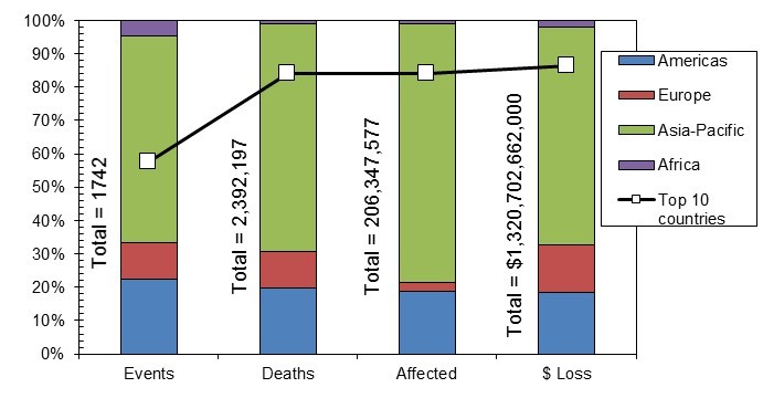 Figure 2. Distribution of events, deaths, persons affected, and economic loss due to geophysical disasters across the globe during the period 1900–2020 AD (Data Source: [57]).
It is also noteworthy in Figure 2 that almost half of these events occurred in the top 10 countries, while the burden of human and economic loss shared by the top 10 countries is more than 80% of the overall total. This finding is in line with the earlier observation that, since the year 1900 AD, only about 100 major earthquakes have resulted in more than 93% of the total fatalities [58] and more than 95% of the total economic loss [59].
The distribution of number of geophysical disaster events, fatalities, number of affected persons, and economic loss for the top 10 countries in each category for the period 1900–2020 is depicted on the world map in Figure 3 and listed in Table 1. Although the numbers of events are distributed more or less evenly among the top five countries, the fatalities and number of affected are disproportionately higher in China (32.5% and 44.9%, respectively), while Japan bore the brunt of the economic loss (46.4%). Italy is the only European country that is among the top 10 countries in three categories, while no country from the African continent is among the pool of top 10 countries for any category. Haiti tops the fatality list in the Americas, while Peru is the only country in this region listed in three categories. More detailed maps of these hotspots are presented in [60].
Table 1. Distribution of events, fatalities, affected people, and economic loss in top 10 countries due to geophysical disasters from 1900 to 2020 AD (Data Source: [57]).
|
Country |
Events (%) |
Country |
Fatalities (%) |
Country |
Affected (%) |
Country |
Economic Loss (%) |
|
China |
20.40 |
China |
32.50 |
China |
44.96 |
Japan |
46.37 |
|
Indonesia |
19.40 |
Haiti |
11.08 |
India |
16.49 |
China |
13.31 |
|
Iran |
13.03 |
Indonesia |
10.79 |
Indonesia |
6.96 |
Italy |
10.91 |
|
Turkey |
11.04 |
Japan |
9.39 |
Chile |
5.78 |
USA |
8.88 |
|
Japan |
8.46 |
Iran |
7.68 |
Philippines |
5.34 |
Chile |
6.54 |
|
Philippines |
7.16 |
Russia |
7.28 |
Guatemala |
4.73 |
Turkey |
3.47 |
|
Peru |
5.77 |
Pakistan |
7.18 |
Pakistan |
4.29 |
Russia |
3.42 |
|
Mexico |
5.17 |
Italy |
5.79 |
Turkey |
4.14 |
New Zealand |
2.91 |
|
Italy |
4.88 |
Turkey |
4.69 |
Nepal |
3.68 |
Iran |
2.12 |
|
USA |
4.68 |
Peru |
3.62 |
Peru |
3.65 |
Taiwan |
2.08 |
|
Total |
1005 |
2009 (thousand) |
173 (million) |
1140 (billion USD) |
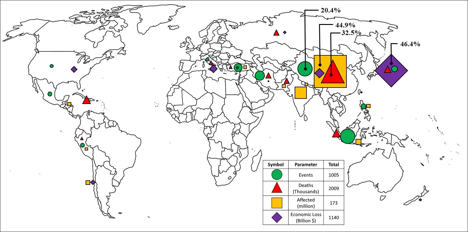 Figure 3. Global hotspots for geophysical disasters based on data for the top 10 countries in each category from 1900 to 2020 AD (Data Source: [57]).
5.2. Hydrological Disasters
Hydrological disasters are caused by floods, landslide, and wave action, with riverine flooding being the most dominant cause for such disasters. The distribution of these events in various regions of the world from 1900–2020 AD, the associated death toll, persons affected, and economic loss are depicted in Figure 4. More than 7 million people lost their lives in these events, and more than 3.8 billion people were injured or displaced in these disasters. The economic toll of these events for the noted period is estimated to be around 1.3 trillion dollars. China was the most affected country, losing more than 6.6 million people in these deluges that also affected more than 2 billion Chinese people. Economic loss in China was also the highest, at more than USD 413 billion. It can be noted in Figure 4 that the Asia–Pacific region was the most affected by these disasters, as more than 50% of events happened here that caused more than 95% of the total global fatalities and displacement of people, as well as more than 60% of the total global economic losses. Social impact of these disasters, in terms of fatalities and people affected, in the Americas and Europe was very low, whereas the economic losses were close to 40% of the global total. This trend of human and economic loss is similar to the one noted for the geophysical disasters across various regions of the world.
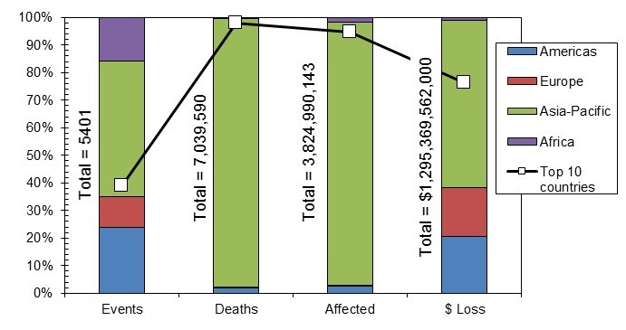 Figure 4. Distribution of events, deaths, persons affected, and economic loss due to hydrological disasters across the globe during the period 1900–2020 AD (Source: [57]).
The distribution of number of hydrological disaster events, fatalities, number of affected persons, and economic loss for the top 10 countries in each category for the period 1900–2020 AD are depicted on the world map of Figure 5, while the percentage distribution is listed in Table 2. Although the numbers of events are distributed evenly among the top five countries, the fatalities, number of affected, and economic loss are disproportionately higher in China (96.02%, 58.22%, and 41.93%, respectively). China lost more than 6.2 million people in just three events. Figure 5 reveals that China and the Indian sub-continent are the hotspots for these disaster events as well as social and economic losses. Italy, Germany, and the UK are the European countries that are among the top 10 countries for economic loss. No country from the African continent is among the pool of top 10 countries for any category. The USA tops the economic loss list in the Americas. It is noteworthy that no country outside the Asia–Pacific region is listed in the top 10 for three or more categories.
Table 2. Distribution of events, fatalities, affected people, and economic loss in top 10 countries due to hydrological disasters from 1900 to 2020 AD (Data Source: [57]).
|
Country |
Events (%) |
Country |
Fatalities (%) |
Country |
Affected (%) |
Country |
Economic Loss (%) |
|
China |
18.14 |
China |
96.02 |
China |
58.22 |
China |
41.93 |
|
India |
17.05 |
India |
1.17 |
India |
24.83 |
USA |
17.97 |
|
Indonesia |
14.58 |
Bangladesh |
0.77 |
Bangladesh |
9.53 |
India |
11.44 |
|
USA |
9.54 |
Guatemala |
0.60 |
Pakistan |
2.23 |
Italy |
6.05 |
|
Philippines |
8.78 |
Venezuela |
0.44 |
Thailand |
1.69 |
Thailand |
5.77 |
|
Brazil |
8.50 |
Pakistan |
0.27 |
Philippines |
0.94 |
Germany |
3.90 |
|
Colombia |
6.46 |
Japan |
0.21 |
Vietnam |
0.92 |
Japan |
3.88 |
|
Pakistan |
6.17 |
Russia |
0.20 |
Brazil |
0.69 |
Pakistan |
3.16 |
|
Afghanistan |
5.94 |
Peru |
0.16 |
Sri Lanka |
0.47 |
North Korea |
2.97 |
|
Bangladesh |
4.84 |
Indonesia |
0.15 |
Colombia |
0.46 |
UK |
2.92 |
|
Total |
2106 |
6902 (thousand) |
3624 (million) |
986 (billion USD) |
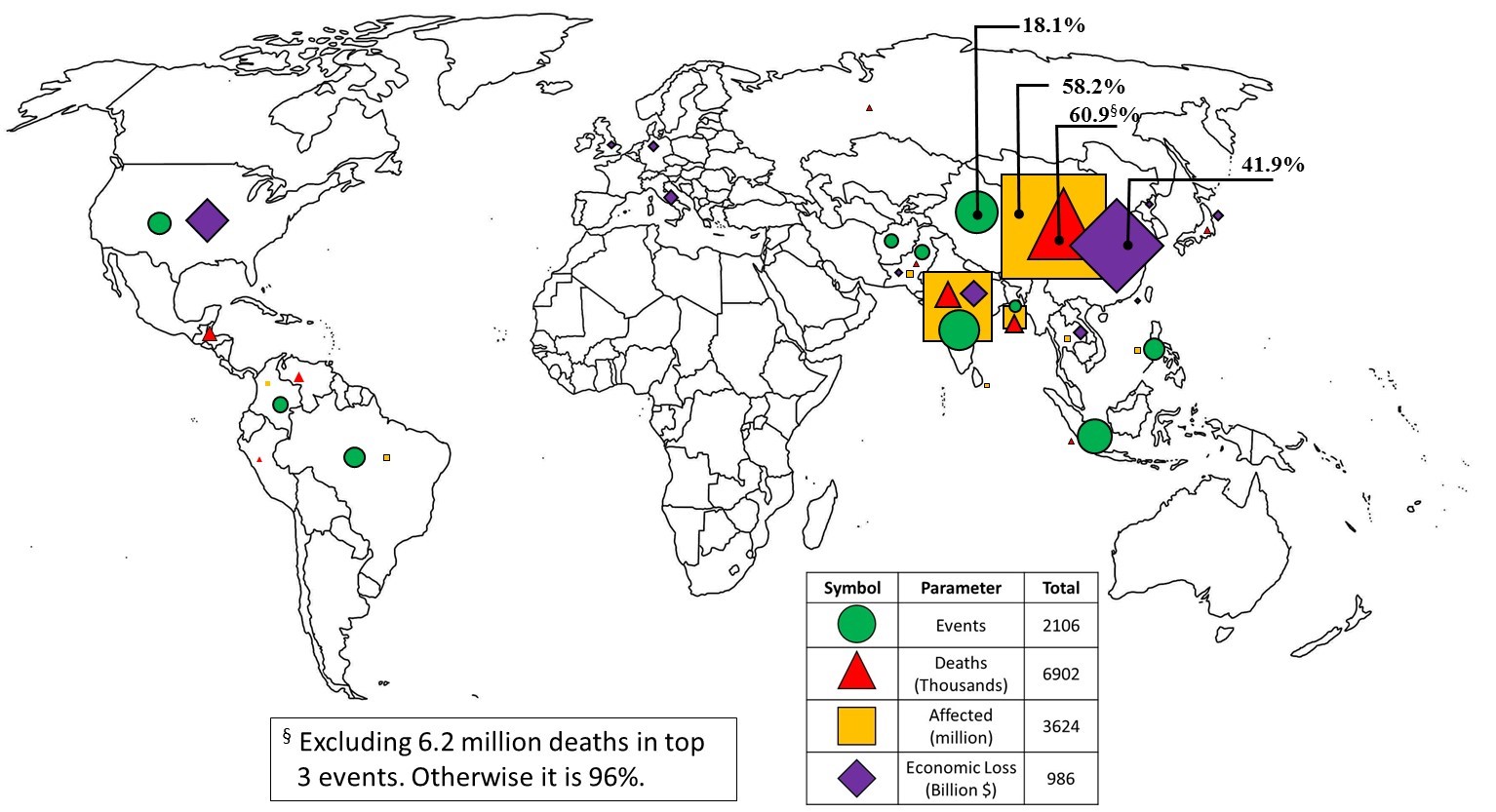 Figure 5. Global hotspots for hydrological disasters based on data for the top 10 countries in each category from 1900 to 2020 AD (Data Source: [57]).
5.3. Meteorological Disasters
Disasters caused by a meteorological hazard can be due to convective storms, extratropical storms, tropical storms, extreme temperature, and fog. In this article, only the effect of disasters caused by storms is discussed. Figure 6 presents the distribution of these storm events in various regions of the world for the period of 1900 to 2020 AD in terms of fatalities, persons affected, and the associated economic loss. Again, more than 50% of the events and more than 90% of the social cost in terms of lives lost and person affected were in the Asia–Pacific region. However, the lion’s share of economic loss was suffered by the Americas, with USA having the largest share in this loss. Similar to geophysical and hydrological disasters, the top 10 countries accounted for more than 90% of the total human and economic losses while subjected to about 60% of these events. The share of African and European continents in social losses was relatively small. However, Europe suffered economic damage roughly proportional to the number of reported events. Overall, about 1.4 million lives were lost worldwide to disasters caused by storms, and more than 1.2 billion people were affected. Total economic loss due to disasters in this category was more than 2.1 trillion dollars, which is the largest among the three types of disasters considered in this article.
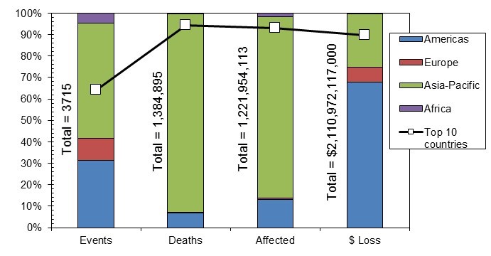 Figure 6. Distribution of events, deaths, persons affected, and economic loss due to metrological disasters (storms only) across the globe during the period 1900–2020 AD (Data Source: [57]).
Global hotspots for disasters caused by storms in the metrological hazard category for the four metrics of number of events, fatalities, person affected, and economic loss between 1900 AD and 2020 AD are depicted on the world map in Figure 7. The corresponding data for the top 10 countries in each category are presented in Table 3. The USA accounted for the greatest number of events (28.4%) and suffered the most economically, i.e., 65.3% of the total loss for the top 10 countries. On the other hand, the most fatalities occurred in Bangladesh (49.63%), and the most people were displaced in China (43.86%). Madagascar was the only African country that was listed among the top 10 in any category (i.e., number of people affected). Four countries from the Asia–Pacific region were among the top 10 in all four categories, while the USA was the only non-Asia–Pacific country to be listed among the top 10 in all four categories for any of the three types of natural disasters studied in this chapter (i.e., geophysical, hydrological, and metrological).
Table 3. Distribution of events, fatalities, affected people, and economic loss in top 10 countries due to meteorological disasters (storms only) from 1900 to 2020 AD. (Data Source: [57]).
|
Country |
Events (%) |
Country |
Fatalities (%) |
Country |
Affected (%) |
Country |
Economic Loss (%) |
|
USA |
28.41 |
Bangladesh |
48.63 |
China |
43.86 |
USA |
65.34 |
|
Philippines |
15.69 |
China |
13.41 |
Philippines |
16.89 |
Japan |
8.42 |
|
China |
13.34 |
India |
12.79 |
India |
13.13 |
China |
7.73 |
|
India |
8.60 |
Myanmar |
11.08 |
USA |
8.92 |
Puerto Rico |
4.08 |
|
Japan |
7.85 |
Philippines |
3.82 |
Bangladesh |
7.92 |
India |
3.02 |
|
Bangladesh |
7.64 |
Japan |
2.68 |
Vietnam |
4.90 |
Germany |
2.91 |
|
Vietnam |
5.25 |
USA |
2.38 |
Cuba |
1.95 |
Mexico |
2.33 |
|
Mexico |
4.95 |
Honduras |
1.90 |
Madagascar |
0.92 |
Australia |
2.19 |
|
Australia |
4.66 |
Hong Kong |
1.82 |
Mexico |
0.76 |
France |
2.18 |
|
Taiwan |
3.61 |
Vietnam |
1.51 |
Japan |
0.76 |
Philippines |
1.80 |
|
Total |
2383 |
1306 (thousand) |
1138 (million) |
1892 (billion USD) |
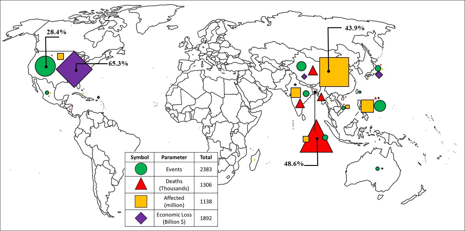 Figure 7. Global hotspots for meteorological disasters (storms only) based on data for top 10 countries in each category from 1900 to 2020 AD. (Data Source: [57]).
6. Natural Disaster Management
Disaster management comprises actions taken before and after the occurrence of a natural disaster to manage the negative consequences of the event. Disaster management is a cyclic process and comprises two stages and four phases, as depicted in Figure 8. Two phases (i.e., prevention and preparedness) precede a disaster event and are categorized as the development stage activities. The other two phases, i.e., response and relief, that immediately follow a disaster event constitute the humanitarian aid stage activities. This comprehensive model of disaster management developed in the USA is termed as PPRR [61]. Risk-driven and vulnerability-focused disaster management paradigms have also been proposed as competing models to PPRR [62–64]. However, the PPRR model is still widely used, and disaster management concepts in this article will be explained based on PPRR.
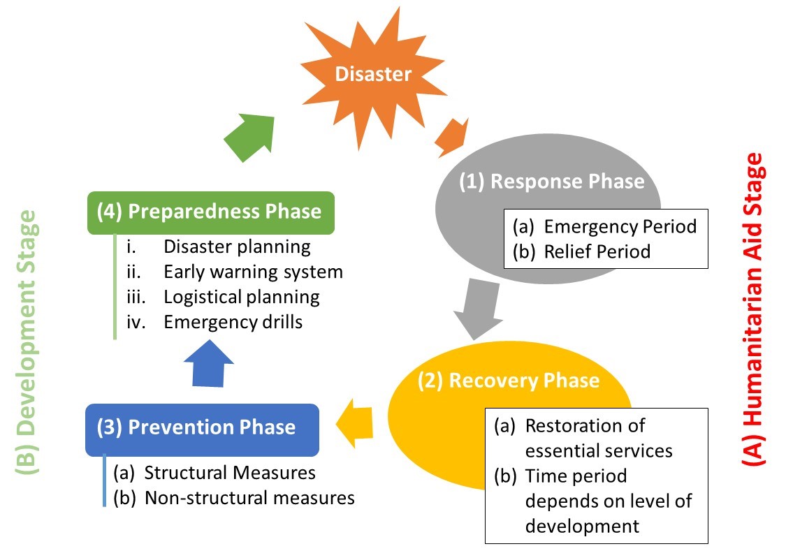 Figure 8. RRPP/PPRR model of disaster management.
Due to its cyclic nature, explanation of the disaster management cycle can start from any phase. Herein, the discussion on the disaster management cycle will begin with the phase immediately following the disaster, i.e., response. Therefore, the model can be renamed to RRPP with no change in the tasks performed in each phase. It is to be noted that RR and PP phases belong to the humanitarian aid and development stages, respectively. Detailed discussion on these phases in the two stages is presented in the following.
6.1. Humanitarian Aid Stage
The humanitarian aid stage comprises the ‘RR’, i.e., response and recovery phases. Discussion on each of these phases is undertaken in the following.
6.1.1. Response Phase
This is the phase immediately following a disaster event that is part of the humanitarian aid stage. The focus of this phase is on search and rescue, preventing further mortalities and meeting the basic needs (healthcare, subsistence, and shelter) of the survivors. This phase can be further divided into two periods, viz., emergency response and relief periods.
- Emergency response period
This is a time-sensitive phase that can last up to a couple of weeks after the disaster event. The main task during the first 72 ‘golden hours’ is search and rescue of disaster victims. Disaster survivors from the community and local medical teams play the most vital role in rescuing and treating the victims trapped in destroyed buildings or other infrastructure during this short period of time in which outside help is unable to arrive and timely join rescue activities. Smith [20] notes that almost 90% of the victims brought out alive from damaged buildings during earthquakes were rescued within the first 24 h. The numbers of survivors rescued from collapsed buildings usually decrease with each passing day after the disaster along with their chances of survival [65,66].
Effective communication is essential for rapid response and rescue efforts. Recently, a new informal communication channel for coordinating disaster rescue operation between affected citizens has emerged, which has utilized various social media platforms to play the role of rescuer, dispatcher, or information compiler [67]. Members of such platforms share information about alternate routes to reach/avoid a disaster area, location of rescuees, condition of damage to infrastructure, health and rescuee needs of affected persons, etc. Academics, disaster management professionals, and governmental agencies have provided policy frameworks and guidelines for the responsible use of social media for disaster response [68–71]. It is also noted with concern that this new form of communication can also be used to misguide, hamper, or even thwart rescue operations [69]. However, recently, social media platforms have been positively employed for rescue operations during hurricanes, rains, and earthquakes/tsunamis [72–75].
Other equally important tasks during this period include provision of healthcare facilities to the survivors, burial of the deceased, provision of shelter and food, and prevention of communicable diseases.
- Relief period
The relief period could last up to 5–6 months after the end of the emergency period. During this period, outside assistance in terms of trained personnel or materials is generally available. The focus is on prevention of additional mortalities and comforting the survivors to restart their lives. Typical tasks undertaken in this period include debris removal, demolishing of unsafe structures, restoration of lifelines (i.e., water, power, sanitation, and transportation networks), provision of temporary shelters and healthcare facilities, post-trauma counseling, and assessment of inflicted damage.
Each type of natural disaster requires a specific kind of medical help during this period. For example, earthquake victims need attention for fractures, respiratory tract infections, trauma to internal organs, and psychological stress, while control and treatment of water submersion (near drowning), snakebites, diarrhea, and communicable diseases is the focus during floods [76].
Although community involvement and tapping into the social network of the affected community are important, a centralized command and control approach to provision of relief efforts has been found to work satisfactorily during this period [77].
6.1.2. Recovery Phase
The recovery phase part of the humanitarian aid stage overlaps the relief period and can continue for many years. During this phase, the emergency situation created by the disaster event no longer exists, and focus is on restoration of daily life and economic activities of the affected population. Priority is given to restoration of essential services such as housing, subsistence, utilities, mobility, and healthcare.
The duration of the recovery phase is strongly affected by the level of development of the affected community [78]. Developing countries may experience slow recovery due to the viscous cycle of underdevelopment, as funds dedicated for development activities will be spent on emergency response and relief [79]. Effective recovery depends on the level of community involvement as well as appropriate and equitable allocation of external funds and material resources. Corruption in allocation and utilization of disaster relief assistance is another prevalent problem [80,81]. The recovery phase slowly blends into the long-term development phases of prevention and preparedness.
6.2. Development Stage
The phases in the disaster management cycle included in this stage, which precedes a disaster event, are the two Ps, i.e., prevention and preparedness. The development stage is the time-period in which a community prepares for a future disaster event. Due to the knowledge accumulated over the past two centuries about the mechanism of natural hazards and occurrence of these hazards in various parts of the world, most communities and nations are aware of the natural hazards frequently faced by them. However, lack of planning, community involvement, political will, or financial resources leave a number of communities unprepared for a future disaster. Therefore, disaster mitigation has been aptly termed as a social rather than a biophysical process [82].
Steps taken and plans implemented during the development stage have a profound impact on the post-disaster phases. This is the stage in which a community builds the necessary resilience to withstand a natural disaster and quickly navigate through the humanitarian aid stage of the disaster management cycle. Building resilience requires involvement of various stakeholders for improving the physical infrastructure, social engagement, disaster planning, and establishing a warning system to reduce the negative consequences when struck with a natural disaster. Such efforts are rewarded with significant payback, as evident from substantially less loss of life and property in recent natural disasters in China [83–85] and other countries [86,87].
A clear relationship between the level of development and the misery caused by a natural disaster in terms of lost lives and economic damage has emerged after careful analysis of natural disasters in the 20th century [88]. Developing countries are stuck in a viscous cycle of under-development, where emergency response and relief efforts after a natural disaster eats up funds dedicated for development activities [89]. Procrastination regarding building the necessary safeguards against future natural disasters is evident in almost all countries around the globe [90,91]. Preventive measures are delayed, even though it is well known that the benefit-to-cost ratio (BCR) of disaster prevention measures is around 60 for flood hazard and varies between 3 and 15 for all other natural hazards across different countries [92].
It was noted by the donor agencies that the situation of natural disaster risk in developing countries has not improved over the years despite spending billions of dollars. For example, World Bank loans for natural disaster relief totaled more than USD 14 billion for the last two decades of the 20th century [79]. Therefore, the focus has now shifted from disaster relief assistance to programs that are more directed towards reducing poverty, building resilient infrastructure, ensuring community participation, and creating social support mechanisms.
As noted in the beginning, the PP phases, i.e., prevention and preparedness, comprise the development stage of the disaster management cycle and are the focus of the discussion presented below.
6.2.1. Prevention Phase
Activities done in this phase are meant to prevent the negative consequences of a disaster event. However, it has been observed that fallout from a natural disaster cannot be fully prevented due to the uncertainties in frequency and magnitude of the hazard(s) as well as capacity of the prevention measure(s). Therefore, the phrase ‘prevention’ is replaced with ‘mitigation’ in recent disaster management literature that focuses on mitigating the harmful impacts of the disaster within a specified probabilistic tolerance. Mitigation measures can be classified as either structural or non-structural, as explained in the following for the three types of natural hazards discussed in this paper.
- Structural measures
Structural measures are the ones that change the characteristics of a natural hazard or improve the strength of an infrastructure component to withstand the impact of the forces unleashed by a natural hazard. Due to the inherent uncertainty of the magnitude and frequency of natural hazards, there is always a non-zero probability of failure of a structural measure. Much effort has been devoted and considerable progress has been made by scientist and engineers over the past 150 years to understand the physical process underlying various natural hazard phenomena as well as to devise cost-effective engineering solutions to improve the strength of the infrastructure components. A brief overview of these efforts, related to the geophysical, hydrological, and meteorological hazards, is presented below.
- Geophysical hazards
Probably the first documented account of adopting engineered structural measures in buildings to withstand the forces generated by earthquakes was in Japan in 1895 [93], while earlier seismic design codes date back to 1927 in USA [94] and in early 1930s in Chile [95] and India/Pakistan [96]. Ever since these early efforts, the field of earthquake resistant design has advanced to the use of various forms of traditional seismic lateral force resistance systems such as ductile moment frames, braced frames, and shear walls, as well as the use of base-isolation, supplemental damping devices, and active control of lateral forces induced by an earthquake in a variety of structures ranging from residential houses to skyscrapers to bridges and nuclear power plants [97].
Despite these impressive strides in the scientific knowledge and engineering applications of earthquake resistant design, the sad fact is that earthquakes are the leading cause of natural disaster mortality, as detailed in Section 2. A further examination [98] revealed that 90% of these fatalities were caused by collapse of non-engineered or semi-engineered structures—mostly houses built of adobe or unreinforced masonry (URM). This seismically vulnerable building stock is present in both developed and developing countries. However, such existing buildings in the developed countries have largely been replaced or retrofitted, and the inventory of the seismically deficient structures is continuously decreasing. Contrarily, in the developing countries, stock of such non-engineered or semi-engineered buildings is steadily increasing, and so is the risk to life and property.
It was noted that the reason for this increased vulnerability is not due to the absence of technical knowledge to cost-effectively build such buildings but an ignorance among homeowners about the available engineering solutions, lax code enforcement, outdated construction practices, and a lack of appreciation for the life-cycle cost and benefit of an improved construction methodology [99]. Detailed guidelines for cost-effective design and retrofit of non-engineered structures was originally published by the International Association for Earthquake Engineering (IAEE) in 1986 and has recently been adopted by UNESCO for widespread distribution [100]. An example of confined masonry for seismic resistance of ordinary houses and simple structures is depicted in Figure 9.
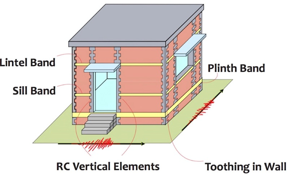 Figure 9. Concept of confined masonry for seismic resistance.
It is relatively easy to enforce improved construction practice in new construction when it is associated with an incentive, as was the case of construction of about 400,000 seismically designed houses in Pakistan after the 2005 Kashmir earthquake [101]. However, it has proven to be a hard task to convince owners to strengthen and retrofit their existing houses [102].
- Hydrological hazards
Two types of structural measures are commonly adopted to mitigate hydrological hazards. One intends to ‘tame’ the flood, while the other provides capacity to withstand the flood waters. Use of the first measure in the form of levees (also called embankment or dykes) to control riverine flooding dates back to early civilizations in China, Mesopotamia, Egypt, and Pakistan almost 4000 years ago [20]. Over the centuries, other means to ‘tame’ the rivers in the form of barrages, dams, and weirs have been devised. The hydrological and engineering aspects of flood control measures are rather well understood. Therefore, the use of structural measures for its control is the most widespread compared to other natural hazards.
The ‘levee effect’, i.e., the sense of security provided by the levee, is the driver for floodplain development and hence the losses associated with the flood when the levee is breached due to a construction defect or poor maintenance or overtopped due to an exceptional flood. Despite the widespread use of levees, flood losses are on the rise [103].
The second form of structural measure against riverine floods is ‘flood proof’ construction. This involves building the structure above the predicted flood level by either building it on an embankment or supporting it on stilts and providing adequate strength in the structural members to withstand the hydraulic forces generated by flowing flood water [104].
In urban areas, the structural measures to mitigate the effect of pluvial or surface flooding caused by rainfall independent of an overflowing water body consist of storm water drainage system, comprising catch pits, manholes, storm sewers, culverts, detention ponds, and pumping stations [105]. Figure 10 details some of the measures that can be adopted to mitigate effects of flood hazard for new and existing developments.
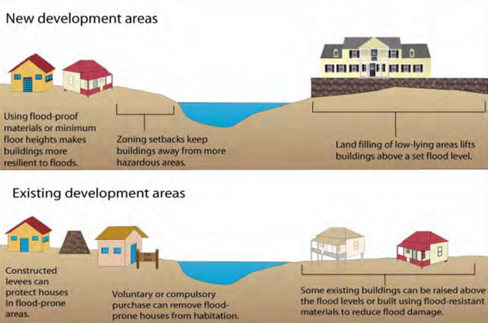 Figure 10. Flood mitigation measures for new and existing developments.
- Meteorological hazards
Meteorological hazards are caused by tropical storms termed as cyclones, hurricanes, or typhoons in different parts of the world. These storms are characterized by strong winds accompanied by rain and storm surge (i.e., an increase in the sea level). A tropical storm has 1 min sustained wind speed between 17.4 and 33.1 m/s, and when this speed exceeds 33.1 m/s, it is termed a hurricane [106]. Structural measures to mitigate the effect of this hazard need to cater for two very different forces of nature, i.e., wind and flowing water. There is a possibility of structural damage due to lateral wind load on the walls as well as uplift of the roof in addition to flooding caused by rainwater or storm surge.
Nearly all types of buildings (wood frame, steel, unreinforced masonry, and reinforced concrete) and their components are at risk of damage or failure due to high winds [107]. As with the seismic design, the main source of failure of these structures is a lack of continuity in the load path from roof/floors to walls to foundations [108]. Foundations could also be compromised due to flooding and erosion caused by flowing water, loss of soil bearing capacity due to submerged water conditions, or loss of stability due to buoyancy [109]. Proper appraisal of wind forces and adequate design of connections against uplift is the key to avoiding structural failure during a hurricane. Most often, the cost of these retrofit and mitigation measures is relatively small compared to the incurred damage [110].
- Non-structural measures
It was noted earlier that the non-structural measures do not rely on physical construction to mitigate the risk associated with a natural hazard but depend on enforcement of building codes and land-use regulations and community awareness to break the disaster–rebuild–disaster cycle. Use of insurance as a collaborative tool is encouraged to share economic losses with wider global financial markets that would otherwise have to be borne by the individuals or governments alone. This section presents an overview of commonly adopted non-structural measures to mitigate the risk of three types of natural hazards (i.e., geophysical, hydrological, and meteorological) that are the focus of this article.
- Geophysical hazards
Earthquakes happen without any warning. Unlike hydrological and meteorological hazard events, there is no reliable scientific method to forecast the location, time, and magnitude of seismic events. Therefore, being prepared and alert is the best defense to reduce human and material losses resulting from seismic hazards. Some of the non-structural measures to reduce risk of seismic disasters are reviewed below:
Land-use planning
Moving out of the seismic-hazard-prone areas seems to be the most logical and effective measure to reduce the risk of this disaster, as the locations of most of the active seismic regions are known through historical accounts or scientific investigations. Enforcing of seismic zoning laws may be possible only for new developments, as adopted in the Alquist-Priolo Earthquake Fault Zoning Act in California that limits any development near active faults [111]. However, such measures cannot be adopted for existing cities such as Tokyo, San Francisco, Tehran, Christchurch, etc., that have witnessed many recorded earthquakes but have surprisingly evolved into even bigger metropolises after successive disaster events.
Relocation of an entire town or a city is not only an expensive logistic nightmare but also a socially sensitive issue. For example, Yungay, a town in the Peruvian Andes, was completely destroyed by mudslides triggered by the Ancash earthquake in 1970, and the surviving residents forced the government to rebuild instead of relocating [112]. Many communities have other compelling reasons to inhibit places of known seismic hazard. In the case of many towns and cities in Iran (Tehran included), it is the lure of life-sustaining water that is brought up from the depths of the earth by seismic faulting associated with earthquakes, which forces these communities to live in the shadow of persistent seismic hazard [113]. These examples illustrate some serious limitations of land-use planning as a non-structural measure to mitigate seismic hazard.
Personal safety measures
Personal safety measures are important to prevent physical injuries, fires, loss of utilities, and damage to non-structural components inside buildings and houses. These measures include securing heavy and movable objects, such as cabinets, furniture, computers, etc., fuel (gas) cylinders, keeping building exits clear of any obstructions, etc. [114]. Injuries and deaths caused by loose objects and fires after an earthquake pose equal hazard to life and property as structural damage to buildings. Education and community awareness play a key part in achieving seismic hazard mitigation goals.
Insurance
Insurance is a disaster management tool that is most beneficial during the recovery phase. However, in order to reap its benefit, it should have been initiated before the disaster, i.e., in the prevention phase of the development stage. The majority of seismic risk around the world is uninsured due to the limited capacity of private insurers to cover the cost of potential damages [115]. This means that, inevitably, the government has to be involved as a provider, reinsurer, or regulator to assist the affected citizens. Setting the right insurance premium is the trickiest part. If it is too low, then the tendency is to have excessive assets built in the exposed area, which may also be of low quality, and if it is too high, then few buy the insurance. Both scenarios increase people’s vulnerability [116].
Access to seismic insurance is available mostly in developed countries and few developing countries. However, even with government assistance, seismic insurance uptake is generally low in most of the seismic hazard prone countries. For example, it is around 20% in California, Mexico, Turkey, and Italy, 30% in Japan and Chile, and 80% in New Zealand [117]. Paleari [118] found that higher seismic insurance penetration in the European Union countries is more, due to government involvement, than its voluntary or mandatory nature. With government support and compulsory offer or purchase, very high (90–100%) bundled seismic and flood insurance penetration is noted in Spain, France, and Belgium. On the other hand, Italy, which has observed the most seismic activity and damage in Europe, as noted in Figure 3, has seen a steady rise in the uptake of seismic insurance since 2009, with a nearly 0% insurance rate of residential properties to about 20% in 2019 [119]. This low uptake ratio in the majority of these countries could be due to high premiums, owner’s perception of risk, insurance history, governmental participation, uncertainties in the seismic loss models, involvement of insurers in development and promotion of seismic research and code development, and other issues [120,121].
The concept of seismic insurance is almost non-existent in developing countries, and its adaptation is a big challenge [122]. The active government role in enacting pertinent legislation and assurance to assist with loss coverage are essential for insurance uptake, as was the case in Turkey, where the Turkish Catastrophe Insurance Pool (TCIP) was established after the 1999 Marmara earthquake, and in Taiwan, where the Taiwanese Residential Earthquake Insurance program was initiated after the 1999 Chi-Chi earthquake. It is estimated that less than 1% of losses due to natural hazards are insured in the developing countries, which constitute a significant portion (almost 13%) of their GNP [123].
Natural hazard awareness and education
Preparedness through natural hazard perception, awareness, and education are of utmost importance to minimize loss of life and property when natural disasters occur. Everyone in a community must know the nature of natural hazards in their environments and how to prepare for them [124]. The National Research Council [125] compiled a very comprehensive set of recommendations for natural hazards education and awareness. NRC proposes national education and awareness campaigns for various levels and forums in society. They include home, community, schools, and the workplaces. All homes should have basic information about natural hazards in that area, emergency supplies, and escape and evacuation plans. Community centers, churches, and hospitals should all participate in natural hazard awareness and education. In addition to evacuation plans and emergency procedures, they should have information on shelter and treatment they would be able to provide in case of a natural disaster.
Disaster training and education is part of the curriculum at school and university levels in many countries all over the world. The Building Research Institute and the National Graduate Institute for Policy Studies in Japan took stock of disaster education at primary, secondary, and tertiary levels in Japan, Fiji, Indonesia, Uzbekistan, India, and Nepal [126]. It traced best practices and guided how countries can learn from each other to improve disaster education. Boon and Pagliano [127] looked into the disaster education in Australian schools and pointed to the need to significantly improve the same. Similar work on disaster education undertaken in parts of world has been reported in articles and reports (e.g., [128–131]).
Situation awareness of natural hazards depends on the type of hazard encountered. The Centre for Disease Control (CDC) provides biological hazard type specific awareness information [132]. Resources for public disaster education and awareness are made available through disaster related agencies such as meteorological departments, wildfire safety agencies, earthquake and tsunami warning agencies, and others. These agencies maintain situation awareness webpages for hurricanes, wildfires, floods, earthquakes, volcanos, and winter weather. The Rural Fire Service (RFS) NSW (Australia) is an example of such agencies. RFS (https://www.rfs.nsw.gov.au/ (accessed on 29 October 2021)) provides real time information about the bushfires (wildfires) on their website and via their smart phone app. The RFS places and manages bushfire warning signs that indicate the level of bushfire threat in real time. The RFS website provides guidance to property owners on how to prepare their properties to avoid damage from bushfires. They also educate the public on how to prepare bushfire survival plans. While such agencies may exist in developing countries, these are often not very active and/or effective in public awareness and education of disasters due to lack of resources and/or poor governance [133].
- Hydrological hazards
Flood risk is not only created by the combination of the flood hazard and the inadequacy of the engineering (or technical) solution. It is a combination of natural, social, cultural, and technological aspects that need to be ethically considered in a holistic manner as opposed to the stand-alone decisions based on technological, materialistic (economical), or political benefits. White [22] was perhaps the first to realize the ineffectiveness of structural measures in reducing flood damages in the US and strongly advocated adaptation of land-use planning as a solution. Ever since, various attempts have been made to include non-structural measures, such as land-use planning, flood plain management, social equity and inclusion, public awareness, and loss sharing through insurance, to mitigate the impact of flood disasters [134].
Structural measures endeavor to keep flood water away from people and property, whereas non-structural strategies strive to keep people and property away from the flood water. Non-structural measures fall into two broad categories: (1) those that modify the susceptibility to damage and (2) those that modify the loss. Flood plain management, flood proofing of structures, flood awareness, and societal participation are examples of the first type of measures while flood insurance represents the second category. Additional details can be found in [135,136].
Land-use planning
Land-use planning as an effective solution for reducing flood related economic loss has been advocated in the USA since 1930s [22]. It was demonstrated through a case study in Austria [137] that implementation of stricter land use control and/or flood proofing measures by the owners reduced the flood risk by about 30%. In contrast, ignoring such measures increased the losses by an additional 17%.
Social justice
It is also argued to include ‘social justice’ in the metric of flood mitigation measures. The authors of a study on this topic state [138]:
“……whatever risk mitigation measures are taken they will never be able to bring equal benefits to all members of the society, and even if they do so for the present generation they may not do the same for future generations. Consequently, on one hand, there will be members of the society who will benefit from such measures in one way or the other, and on the other hand, there will be other members of the society who will be more burdened by the same measures”.
Inclusion of the ‘social justice’ element is especially critical in the case of implementation of extensive structural measures in developing countries that are funded by borrowed funds through international donors. There is a propensity among the aid donors to push for solutions that are better suited to serve the political and technical establishments of their countries with little regard to the social and cultural norms of the recipient country. A flood control mega-project in Bangladesh can be cited as one such example where various governments and international aid agencies influenced different aspects of the project [139].
- Meteorological hazards
Regions prone to hurricanes are well known. However, exposure of human populations and related assets to hurricane hazard has different reasons in developed and the developing countries. In the US, the population of these coastal regions has almost doubled since 1960 due to the lure of beach, blue waters, and sunny weather. As a result, costly building assets are willingly exposed to hurricane risk. However, for millions of people living in the Caribbean islands and coastal areas of Bangladesh and India, there is no choice other than to live with the consistent threat of hurricane winds and storm surge. Community preparedness, storm warning system, and storm shelters are effective means to mitigate threat to life and property [140].
Meteorological hazards are characterized by high wind, moderate-to-intense rainfall, and storm surge. Non-structural measures can be effective against flooding and storm surge, while structural measures need to be adopted for protection against high winds. Land-use planning provides basic guidelines for development in coastal zones that caters for risk caused by the combination of high winds, urban flash flooding, and storm surge. The adoption of updated coastal hazard risk maps often faces challenges from developers and owners due to potential devaluation of the properties and increase in insurance premiums.
Coastal zone management
Utilization of stabilized sand dunes, coastal mangrove forests, man-made breakwaters, and sea walls are important defense mechanisms against storm surge, as depicted in Figure 11. These mitigation measures may not fully protect coastal structures from flooding but help in reducing coastal erosion. A mix of structural and non-structural measures, depending on the local geophysical conditions and community needs, usually result in a sustainable solution.
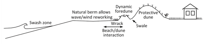 Figure 11. Use of sand dunes for protection against storm surge.
Loss sharing through insurance
Storm and flood insurance is almost non-existent in developing countries. Therefore, the losses are borne mostly by individuals, accompanied by some contribution by the national government. However, efforts are being made to extend insurance cover in these countries through subsidized schemes [141,142]. In the USA, the problem is complex, as almost 80% of at-risk properties are insured, and in the event of a major hurricane disaster, the insurance industry is faced with huge liabilities.
6.2.2. Preparedness Phase
This phase in the development stage of the disaster management cycle immediately precedes a disaster event and critically affects emergency response during the initial phases of the disaster. It is imperative that disaster preparedness plans are in place for various scenarios of anticipated natural disasters and various dimensions of vulnerability so that prompt actions can be taken to save lives and lessen the impact of economic loss.
It is important to recognize various dimensions of vulnerability to natural disasters for effective preparation and response. Vulnerability is the propensity of an asset or people or an institution to suffer damage and lose functionality as the result of a disaster. The various dimensions of vulnerability are: physical (risk of damage to physical infrastructure such as buildings, transportation networks, flood protection works, etc.); economic (impact on agriculture, fishing, commerce, and manufacturing); institutional (providing effective leadership, support, response and protection to the affectees in a streamlined manner without a chaos); and social (awareness and knowledge of disaster, ability to act on warnings and follow competent authorities, social bonding and cooperation, and insurance to cover the economic losses). Important dimensions of vulnerability of a community need to be properly assessed during the disaster preparedness phase, and appropriate contingency plans are to be prepared for effective response during a disaster.
The aim of this phase is to achieve a readiness level that is appropriate for the type of encountered disaster by building leadership, organizational, management, and technical capabilities at institutional, societal, and individual levels. Specific measures that can be taken during this phase include the following:
- Disaster planning
This includes drawing and following up on long- and short-term disaster emergency response mechanisms and procedures that detail responsibilities and actions of various organizations and individuals and clearly establish chain of command and communication protocols. Such disaster planning is recommended for communities and nations that are historically prone to natural disasters. Other activities include construction and regular maintenance of disaster shelters, publicizing of evacuation routes, provision of transport for evacuation, and safety and well-being of evacuees.
- Early warning system
Establishment of a reliable early warning system can save numerous lives for slow-onset disasters such as floods or storms. It is also important that the warning message is conveyed to the targeted population segment in a clear way; preferably, according to a well-established protocol, using a well-publicized or mutually agreed mechanism (e.g., public alarms, radio, TV, social media, etc.). Technological advancements and utilization of scientific knowledge is a key component of such warning systems.
With the widespread use of mobile telephones, social media has emerged as a new form of communication, through which warning messages can be reached out to people who are potentially in the harm’s way. Use of social media is no longer limited only to the search and rescue phases. It is being actively used to educate people about the risks associated with natural hazards, to adopt proactive measures for reducing the impact of a future disaster, and to create awareness [143–146]. Citizens expect disaster management agencies to engage with them through social media [147]. This is the reason that Red Cross, FEMA, CDC, NOAA, many city fire and police departments in USA, and other organizations have active and updated social media accounts on various platforms. As a case study, Tagliacozzo and Magni [148] analyzed how social media was effectively used for the post-disaster recovery (PDR) phase following the Emilia Romangna (northern Italy) earthquake in 2012. They found social media helpful at a grassroots level, enabling peer-to-peer communication for mobilizing public opinion about the reconstruction efforts.
- Logistical planning
This includes ensuring a sufficient stockpile of life-saving medicines, food, water, emergency power source, transportation, rescue equipment, and trained emergency response personnel. Mobilization and deployment of the army to assist the civilian administration can also be a part of such planning.
- Emergency drills
Emergency drills ensure the level of preparedness and can identify any lapses in planning and response. These drills include individual response during an emergency situation caused by the natural disaster, as well as societal and organizational responses. These rehearsal drills are effective defense mechanisms against rapid onset natural disasters such as earthquakes or fires.
- Knowledge and awareness
The role of natural hazard awareness and knowledge has already been emphasized in Section 6.2.1. Being knowledgeable of the nature of the natural hazard and various dimensions of vulnerabilities associated with it takes the ‘surprise factor’ out of disaster response. It prevents chaos and confusion and helps in coping with the disaster situation with focus and calm. Awareness and knowledge of individuals is a critical factor in rescue operations during the first few hours of a disaster occurrence, when limited outside help is available.
7. Challenges and New Directions in Natural Hazard Preparedness
Climate change is increasing extreme climatological events in both intensity and frequency. As a result, storm- and flood-related disasters are increasing and becoming more devastating. Continued population and economic growth are leading to ever-increasing natural resource consumption. Humans are increasingly encroaching on natural areas and coming into contact with natural processes. That is increasing disaster vulnerability. In the following accounts, both the challenges of and new directions in natural hazard preparedness are elaborated.
7.1. Population and Economic Growth
The world human population has exploded to about eight billion from close to one billion one hundred years ago [149]. It is forecasted to continue to grow in the future. The UN estimates that the human population will increase to ten billion by 2050 [149]. Seven billion people that were added in the last hundred years had to be provided with shelter, food, water, clothing, household objects, and means of transportation. That need was fulfilled by enormously increasing exploitation of natural resources, including land. Vast swaths of natural forested land had to be converted to human settlements, agriculture, aquaculture, and other anthropogenic land uses [150]. The loss of natural lands was also due to adoption of low-density car-reliant suburban development. Greek planner Constantinos Doxiadis pointed out that average densities in several major cities decreased by two-thirds in the 40 years to 1968 [151]. TNC [152] forecasts that, at the current rate of urban expansion, the world will encroach into natural lands equal to the size of London every seven weeks.
Expansion of human settlements and activities into natural lands has increased human exposure to natural disasters in multiple ways. Human settlements have had to be built in more precarious lands in river catchments, on unstable grounds, in steep hills, closer to fire-prone forests, etc. In addition, loss of natural wooded land reduced the ability of land to slow down the rainfall runoffs, increasing risk of flooding. Replacing natural wooded and grassed surfaces with less pervious agriculture and impervious concrete and bitumen surfaces, as well as replacement of meandering natural streams with straightened and concrete lined canals and drainage channels, leads to excessively high and fast runoff [153]. Expansion of land under human habitat thus has led to increased exposure to floods, landslides, droughts, and wildfires.
7.2. Climate Change Related Weather Extremes
In July 2021, Germany and Belgium experienced intense rainfall and floods that had never been experienced before. Unprecedently intense rainfall and resulting devastation is linked with climate change [154]. The floods caused 184 deaths and property damage of more than EUR 2.5 billion in Germany [155]. Unprecedented extreme weather events are being observed in all parts of world with increasing frequency. In early September 2021, New York (NY) and New Jersey (NJ) experienced more than 100 mm/h of rainfall for extended periods. That intensity of rain was never seen before [156]. The rain flooded NY subways and transformed Manhattan streets into rivers.
Climate change-induced heat in the Earth’s atmosphere is causing extended wildfire season and more extensive damage all over the world [157]. Unprecedentedly extensive and prolonged wildfires in California and in Australia are examples of that. In the Southern Hemisphere summer of 2019–2020, Australia experienced a mega bushfire that burnt about 20 million hectares of land and displaced or killed nearly 3 billion animals [158,159].
The world continues to release very high volumes of GHG (greenhouse gases) resulting from population and economic growth and a consumptive lifestyle. The Earth’s atmosphere is thus likely to continue to heat up for many years to come. The Intergovernmental Panel on Climate Change (IPCC) anticipates that the world will see an increasing frequency and intensity of weather patterns, causing ever-bigger disasters [157]. It also warns that the poor and dense areas of the world are the most vulnerable from climate-induced extreme weather events of rainstorms, cyclones, heatwaves, and droughts [157].
7.3. Better Weather and Climate Change Modelling
Tradition hydrological modeling is based on probability analysis of occurrence of rainfall events of a certain intensity and related forecast of flooding. This analysis entirely relies on historic rainfall data to estimate the probability of floods likely to occur every certain number of years—such as one in one hundred years. Related to those estimates is the demarcation of areas that would come under water when a flood, say, one in one hundred years, occurs. Hydrological modeling has assisted in locating new human settlements outside one in one hundred years flood zones [153] and thus largely out of the way of harm of the frequent floods.
Hydrological modelling relies on historic rainfall data that goes back to the latter half of the 19th century, when measurement and recording of rainfall began [160]. However, due to climate change, historic data is no longer a good predictor of the rainfall intensity and flood frequency [161]. One way of dealing with the uncertainty of rainfall in the future is to extend the rainfall records of past 150 years to a much longer period in the past, with estimation of older rainfalls from thickness of annual tree rings and annual alluvial deposits [162]. A second way of dealing with uncertainties introduced by the changes in rainfall patterns is to integrate hydrological modeling with the climate change modelling [163]. However, significant improvements in climate change models are required to achieve this integration. It is also reported that the clouds and precipitation forecast part of climate change models need significant improvements as well [164].
7.4. Compact and Sustainable Living
First and foremost, the biggest contributors to climate change and hence increasing risk of disasters must be tackled through modifications in the way people live. Resource- and energy-intensive suburban life in large houses and mobility reliant on cars will have to change. Living in smaller dwellings and compact neighborhood with access to transit for travel would reduce both encroachment into the natural lands as well as reduce GHG emissions. City planners have, for decades, advocated higher densities through concepts of smart growth, new urbanism, and transit-oriented development (TOD).
The concept of smart growth arose from the negative impacts of the low-density car-reliant urban development. smart growth, a USEPA collaboration, promotes compact and walkable, self-sustaining, and attractive urban development [165,166]. New urbanism recommends a gridiron street pattern, narrow streets, smaller lots, and shallow setbacks for achieving walkability and compactness [167]. Transit-oriented development (TOD) recommends higher densities and mixed-use urban nodes that are connected to each other by transit bus, light rail, or metro lines.
8. Conclusions
The Earth’s landscape is a product of natural processes of earthquakes, floods, cyclones, storms, wildfires, volcanic eruptions, and landslides. Disasters take place when these processes interact with human settlements and/or human economic activities. This article presents a broad and in-depth analysis of natural disasters, focusing on their origin, impact, and management. It describes a brief history of impacts of natural hazards on the human built environment. It lays out an account of natural processes and theories related to natural disasters. Theoretical knowledge in this field has evolved over the years. While in the past, they were attributed to acts of gods or acts of nature, they are now understood as a complex nexus of natural–human–social–economic factors.
A very elaborate discussion on global impacts of natural disasters is included in the paper. The paper provides detailed and spatially-differentiated statistics on harm from the natural disasters for various categories of natural hazards. About 85% of the world’s population has been affected by at least one natural disaster in the past 30 years [54]. A significant loss of human life is also associated with natural disasters that kill 60,000 people on average yearly [168]. Ninety percent of these fatalities take place in developing countries [56].
The impact of natural disasters is growing due to their increasing frequency due to climate change and increasing human encroachment and encounter with nature. In the twenty-year period from 1980 to 1999, 4212 disasters were recorded all over the world. In the same period, 1.19 million lives were lost, 3.25 billion people were affected, and USD 1.63 trillion in economic losses was incurred from these disasters. In the 20 years that followed (2000 to 2019), a large increase was recorded in number of disasters (7348), number of people affected (4.2 billion), and economic loss (USD 2.97 trillion) [169]. That increase in disaster frequency and damage is attributed to climate change, which is making climatological events more frequent and more extreme.
The paper covered a thorough discussion on natural disaster management. The four-phase PPRR—preparedness, prevention, response, and recovery—model is described in great detail. Various common techniques adopted for natural disaster preparedness, including structural measures for preparedness, are elaborated. Details of various responses adopted at various stages of disaster are also described.
Awareness and education play a vital role in disaster preparedness and mitigation. Natural hazard awareness and education is to be tailored for different demographics. The situational awareness would also be different depending on the type of natural hazards. The education and awareness can and should take place at all administrative levels, i.e., local, regional, national, and international. The paper also presented other aspects and dimensions of awareness, of which social media and new tools such as smartphone apps are the most noteworthy.
Huge advancements have been made in the past few decades in the forecast and modelling of natural hazards, disaster communication and warning systems, transport and mobility for quick evacuation and arrival disaster relief, and technology to build safer structures. However, lack of resources, unchecked population growth, political instability, dysfunction and fatalism in poor countries, and continuation and expansion of highly consumptive and unsustainable lifestyles in richer countries remain significant challenges.