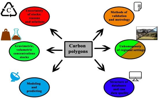
The most important area of study concerning carbon polygons is the problem of assessing the reserves and trends in the stability of organic matter in the soil of natural ecosystems. An adequate assessment of these stocks should be based on verified methods for determining the content of organic matter (direct and indirect methods and the problem of the correlation of results) and on unified ideas about the depth and regularity of sampling within soil profiles and monitoring sites. This problem is particularly relevant to the development of a spatial network of carbon polygons in the Russian Federation.
- carbon polygons
- carbon sequestration
- climate change
- carbon balance
- soil organic matter
1. Introduction
Soil organic carbon (SOC) is the main component of soil organic matter (SOM) [1][2][1,2]. SOC can be assumed as an indicator of soil health and plays a critical role in food production, climate change and sustainable human development [3][4][3,4]. In the face of climate change, SOC can be mineralized faster and become a significant source of greenhouse gases in the atmosphere [5][6][5,6]. However, the overall impact of climate change on SOC content differs depending on region and soil type [7][8][9][10][11][12][7,8,9,10,11,12]. Climate change can have catastrophic consequences for SOC and soils [2][4][9][2,4,9]. As a result, we can observe land degradation in various areas of the planet (the Arctic, desert and mountainous zones) [3][13][14][15][3,13,14,15]. Today, the world’s soil contains up to 1500 Pg (1 × 10 15 g) of soil organic carbon in the upper meter horizon [3][4][16][3,4,16]. The soil with the richest SOC levels (Histosol and Chernozem), as well as drylands with low carbon content, have the potential to make the greatest contribution to climate change [9]. The areas occupied by permafrost-affected soils make up more than 8.6 million km 2, roughly 27% of all land north of 50° N, meaning that up to 1024 Pg of soil organic carbon is stored within the upper 3 m of soil [1][17][1,17]. Thus, the management of these territories can enhance the sequestration of carbon in soils, contributing to the mitigation of climate change on our planet [2][3][4][9][2,3,4,9].
The soil cover of Russia holds the largest store of carbon in the whole world and is the most important area for carbon deposition in the northern hemisphere. Carbon stock in soils and biosediments have been evaluated by numerous investigators [4][7][9][12][14][4,7,9,12,14]. During the Postsoviet era, the sequestration rate of carbon in soil increased sharply due to abandoning of millions of hectares of arable lands and afforestation of former agricultural lands [18][19][18,19]. Thus, the abandoned agricultural lands were formed in various bioclimatic environments, and have recently been used for retrospective analyses of soil parameters by numerous researchers [20][21][22][23][24][20,21,22,23,24]. In this context, the forthcoming plans regarding the creation of special monitoring plots state that carbon polygons should be considered and discussed in terms of pedological methodology with the aim of mutualizing carbon poll assessments with carbon offset risks in our national environmental economy and carbon market.
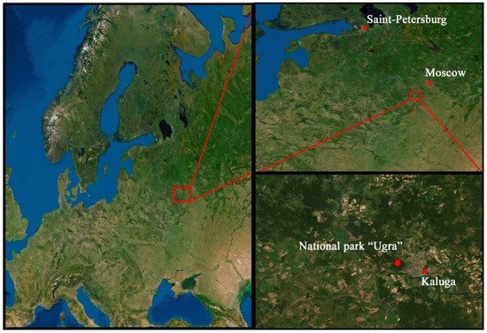
Carbon polygons are places where carbon dioxide emissions and accumulation are monitored under conditions of various types of relief and soil cover [4] ( Figure 1 ).
Today, Russia has the only “Ugra” carbon polygon it located in the Kaluga region, which is a place for studying the global carbon balance and sequestration potential of the territory ( Figure 2 ). It is planned to create polygons in Kaliningrad, Krasnodar, Sverdlovsk, Tyumen, Novosibirsk and Sakhalin regions as well as Chechen and Tatarstan republic up to 2022. Thus, the formation of carbon polygons in Russia will allow for the creation of a monitoring network that will study the processes of formation, accumulation, emission and deposit of priority greenhouse gases in various ecosystems of our country [25][26][25,26]. When forming carbon polygenes in natural zonal environments, industrial areas, large cities and anthropogenic ecosystems, it will create a reliable and productive monitoring network that will contribute to the study of the planetary carbon cycle and sequestration potential of the territory of the Russian Federation. This will allow to Russia to comply with the goals set out in the Sustainable Development Cooperation Framework of the UN and the Paris Climate Agreement [27][28][27,28].
2. Carbon Polygons: Current State and Key Challenges
In Russia, different concepts are used regarding soil organic matter and humus compared to the EU and the USA. In the EU and USA, the SOM includes the following fractions: plant residues, particle decomposed plant materials, soil microbial biomass and humus [4]. In Russian pedology, humus is often understood as a colloidal organic substance that consists of humic acids and the precursors of humification (proteins, carbohydrates, lignin and aldehydes). Organic residues presented in the form of peat, sapropel, plant litter and organic fertilizers are not considered humus in the Russian School of Soil Science [29][30][41,42]. This is why, when determining carbon in fine earth, roots and detritus forms of organic matter are extracted, a process that is not always practiced in the EU and USA. Therefore, the concepts of humus, soil organic matter and total organic carbon, are not equivalent [31][32][43,44]. The concept of “carbon of organic compounds” also differs from them. Thus, we have to decide what we will use for monitoring and from which horizons we will gather regular samples, e.g., are we going to include a forest floor or all superficial undecomposed organic matter, which is an important part of stock [31][33][34][35][36][43,45,46,47,48] but not stabilized? The sequestration of organic carbon occurs at various levels of organization of organic matter, in forest litter, in peat and in the organo–mineral and mineral horizons. Due to various stabilization mechanisms (mechanical, chemical and molecular), SOM is transformed into a more stable form and can be stored in a soil for a long time [14][37][14,49]. Another important question is related to sampling depth: 0–20 (arable layers), 0–100 (the average depth of soil in Eurasia) or the horizontal approach (sampling form each soil genetic horizon). Thus, we have numerous key questions on sampling strategy that we must discuss and define at the very beginning of polygon creation.
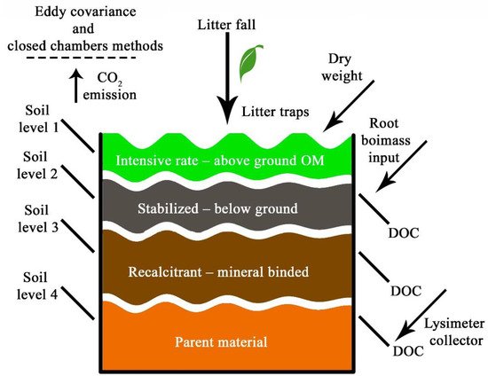
Currently, carbon polygons proposed by the Ministries of Education and Science in the Russian Federation [38][50] do not cover all natural zones. The proposed approach is based on the location of polygons in different areas of the Russian Federation. However, not all of the natural conditions, even at the biome level, will be covered by the proposed network of polygons, which will lead to distortions and inaccuracies even in approximate assessments. The planned network of carbon polygons does not yet include cryogenic soils found in of the circumpolar environments, in which huge reserves of organic matter are concen trated. It is necessary to pay special attention to the need to expand the network of carbon polygons to all natural zones of Russia. Russian boreal soil, polar soil and subsurface sediments possess the highest stock of carbon in the northern hemisphere; nevertheless, the stocks of organic matter in these environments are underestimated due to the complex heterogeneity of the territory and the presence of permafrost tables on soil [1]. Thus, the question of covering the country with the polygons is a keynote for the accurate assessment of carbon stocks, taking into account the unique phenomena of soils and environment zonality, which has been elaborated by V.V. Dokuchaev [29][41]. If Russia follows a zonal approach in the spatial distribution of polygons, it will become a standard for the whole world—all types of biomes will be covered, except for tropical ones. In this context, the previous experience of the International Biological Program should also be obtained [39][40][51,52]. The soils of Russia, taking into account the greatest pedodiversity, should be a standard in terms of humus state and carbon content metrology ( Figure 3 ).
Modeling is a critical tool for predicting and analyzing large amounts of data, including carbon data. Modern mathematical simulation models (Romul, Efimod) allow one to process large amounts of soil–climatic and soil–chemical data to predict the dynamics of the content of various fractions of organic matter, from easily decomposable to highly stabilized [31][33][34][36][43,45,46,48]. Soil–climatic data are currently in deficit; therefore, a long-term temperature and water content logger should be inserted into the soil, at different depths to provide an automatic meteostation on the soil’s surface. High-accuracy simulation modeling is not only important from the point of view of basic science; it is also important for the forecasting markets of carbon units and carbon offsets. Every type of carbon market should be targeted by a prediction system, such as a mathematical simulation model. This model should be verified using the input data derived from carbon polygons. The use of GIS systems is also crucial for the generalization of big raw data and the visualization of boundless information [39][40][51,52].