Your browser does not fully support modern features. Please upgrade for a smoother experience.
Please note this is a comparison between Version 1 by Ashutosh Sharma and Version 2 by Vicky Zhou.
Urban land suitability could be evaluated from the aspects such as the imbalance of the existing land-use structure and function distribution, along with the scarcity of land resources, so as to provide people with more a rational use of land service space.
- geographic information system (GIS)
- urban land planning
- suitability evaluation
- intercepting flood ditch
1. Introduction
The advancement in the economy and technological dependence has led to the increasing demand for urban residential area in various countries around the world. Various serious issues have been raised due to the rapid increase in the urbanization rate such as air pollution, imbalanced land-use structure, lack of traffic management, and many more [1][2]. This situation has raised the social economic burden on the management and environment for optimization of urban residential land, requiring the help of various urban planning agencies. This raises the need for a reliable and quantified urban residential environment for building a more improved understanding of the process of urbanization. In order to analyze this viewpoint, various factors should be kept in mind to understand the complete scenario of a land-use factor. Figure 1 depicts the land-use factors which generally affect the urban land distribution.

Figure 1. Land-use factors affecting the urban land distribution.
Table 1. Descriptive analysis of various land suitability methods.
| Research | Crop | Methods | |
|---|---|---|---|
| Bagherzadeh and Gholizadeh | [9] | Alfalfa | Artificial Neural Network (ANN) |
| Bagherzadeh et al. | [10] | Soyabean | Fuzzy approach |
| Danvi et al. | [11] | Rice | Machine Learning (ML) |
| Deng et al. | [12] | Rice | ANN + Genetic Algorithm (GA) |
| Estes et al. | [13] | Maize | Machine Learning (ML) |
| Lopez-Blanco et al. | [14] | Several Crops | Fuzzy approach + ML |
| Raza et al. | [15] | Several Crops | Fuzzy approach |
The literature presented in this table depicts various approaches utilized by food and agricultural organization for land suitability frameworks. Most of the identified tractional methods indicates that the socioeconomic data are minimal, and this is very critical in the case of conducting the assessment for crop suitability [16][17]. Some of the approaches also pointed out the limitations of using the ordinal linear combinations for addressing the problems which are needed to practice the non-linearity. It was also revealed that the suitability and vulnerability of the transcending approaches is more in the cases of qualitative and quantitative analyses.
2. Evaluation of Suitability of Urban Land Using GIS Technology, Take Yan'an as an Example
2.1. Analysis on the Evaluation Results of Land-Use Suitability in the New Planning Area
The suitability level and degree of impact of subdivided construction land need to consider the characteristics and distribution of the current topography of the planning new area [18][19]. The northern New Area of Yan’an has many mountain structures and complex topography, which poses certain limitations to the construction of urban land. Combining the four major influencing factors mentioned above and analyzing through the GIS system, the suitability construction distribution map is obtained. According to the above calculation method, the degree of influence of each evaluation factor is obtained. Then, through the ArcGIS weighted synthesis tool, the weight of the construction land is obtained. Figure 26 shows the resulting weight map. According to the result of the superposition analysis, the suitability construction level of the planning new area is divided into three types: suitable construction area, generally suitable construction area, and unsuitable construction area. Finally, Figure 37 shows the most suitable construction land area, which is about 80% of the total planning area. The banned construction area occupies the smallest land area, about 4% of the total planning area.
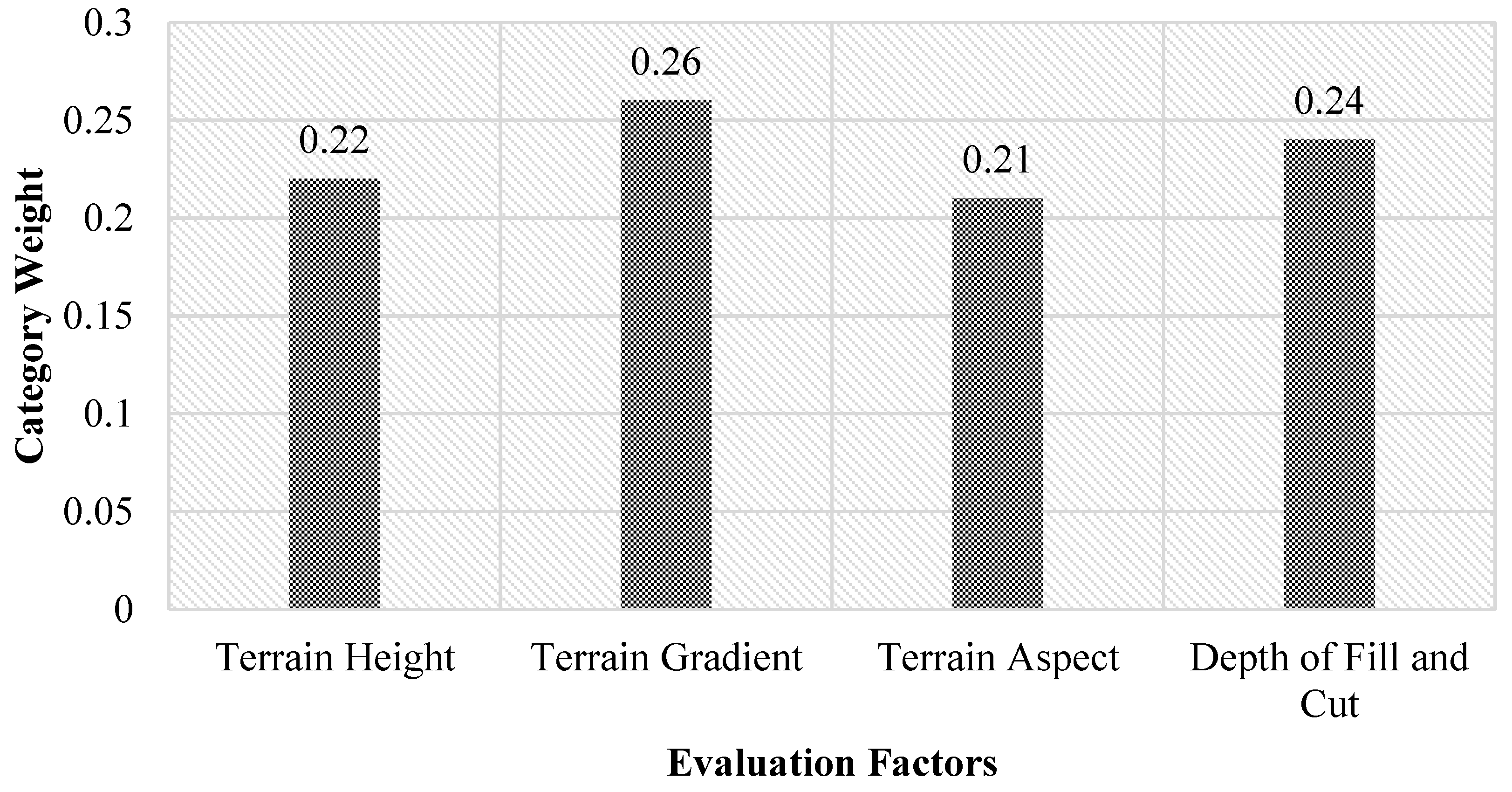
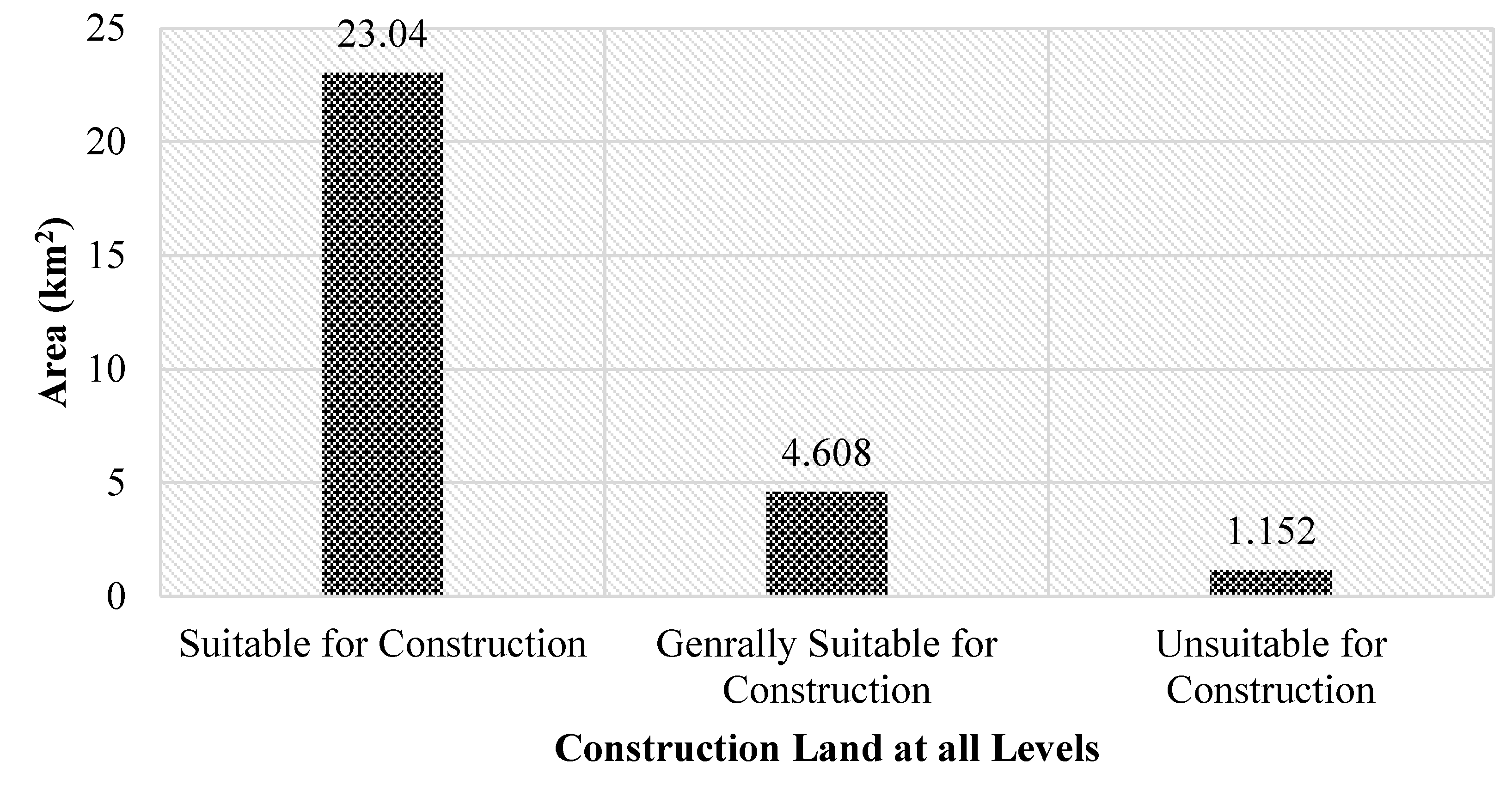
Figure 26. Index weights of the evaluation system for the suitability of construction land.
Figure 37. Distribution of floor area of each grade.
Unsuitable construction land is mainly distributed at the backbone of the mountains in the planning new area. The filling area larger than 40 m contains more than 55% slope. The loess quality in this area is not stable and suffers from natural disasters throughout the year. This area is unsuitable land construction. To ensure people’s personal safety and property, all construction related to human activities is prohibited. This area covers an area of 1.152 HA, accounting for 4% of the total planning land area. Generally, the construction of suitable land mainly includes a slope of 15–55%, and the distribution is relatively scattered. Generally suitable land is suitable for the construction of ecological green space to protect the natural environment. The area covers an area of 4.608 HA, accounting for 16% of the total planning area. If certain engineering techniques are used, generally suitable land can also be used as constructive land. The loess quality of the suitable construction land is stable and suitable for the construction for various activities. The distribution of suitable construction land is also concentrated. The terrain slope factor has little effect on the construction of this area. The aspect is also more suitable for construction. The area covers an area of 23.04 HA, accounting for about 80% of the total planning area. In summary, this area can be used as a centralized construction land. Observing the laws of nature is a prerequisite for building a city. It is the responsibility of each of us to protect the ecological region. Then, the construction land needs to protect the good original conditions of the original land. At the right time, the appropriate methods and technologies are used to plan urban construction scientifically and rationally.
2.2. Analysis of Safety Planning for Ecological Protection
A large amount of filling and excavation is required at the edge of the land topography transformation, which changes the original land shape. Then, natural disasters must be prevented at this time to protect the terrain and slopes. Figure 48 below shows the design of the slope protection.
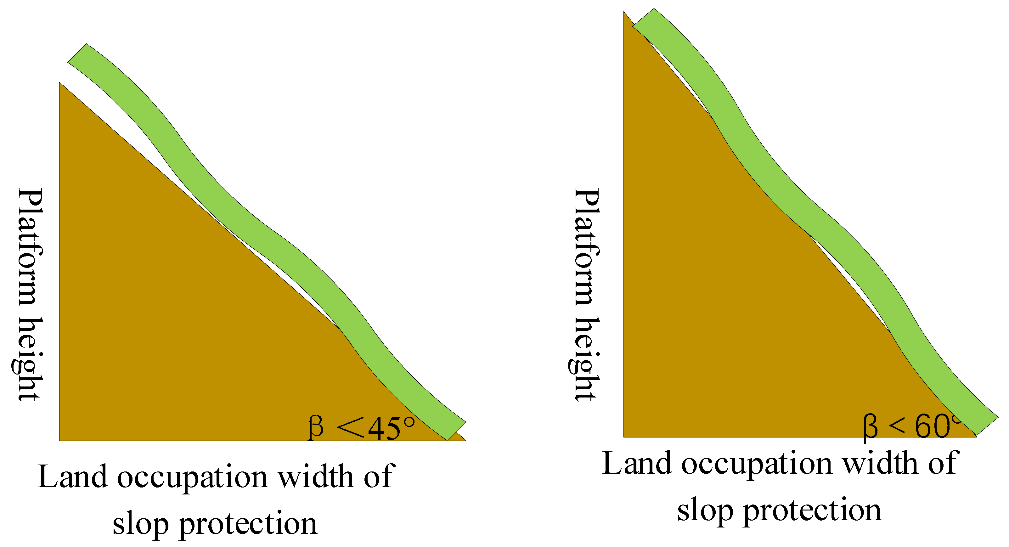
Figure 48 shows the design requirements for slope protection. The minimum protection slope is not recommended to be less than 45 degrees. If the protection slope is less than 45 degrees, it leads to an excessively large area and a waste of land resources. The protection slope is greater than 60 degrees, which is prone to landslides, and the safety factor is not high. Therefore, the range of the protective slope should be controlled between 45 and 60 degrees.
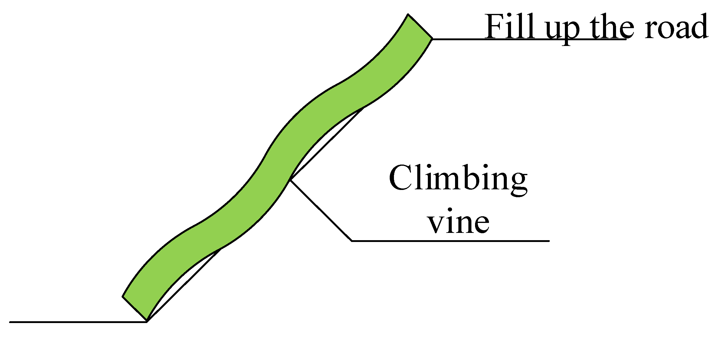
Figure 59 shows the protective slope of the filling area. The protective slope forms a gentle green slope, and fills the edge of the filling to integrate it with nature.
 The excavation area is divided into the edge of excavation within 10 m protection slope, 10–20 m edge zone protection slope, 20–30 m excavation edge zone protection slope, and over 30 m excavation edge zone protection slope. The 10–20 m edge protection slope construction land is retreated 45 m to protect the side slope withdrawal. The 10–20 m edge protection slope construction land is designed as a stepped small platform. The small platforms are generally designed to be 3.2–4.2 m wide with a vertical spacing of 8.2–12.2 m. This can make the slope smooth and prolong the service life. The edge protection construction land within 10 m is set back by 45 m, and it is more appropriate to plan it as a green slope. Figure 610 shows the edge protection slope of 20–30 m. The gradually increasing design slope is safer and more economical.
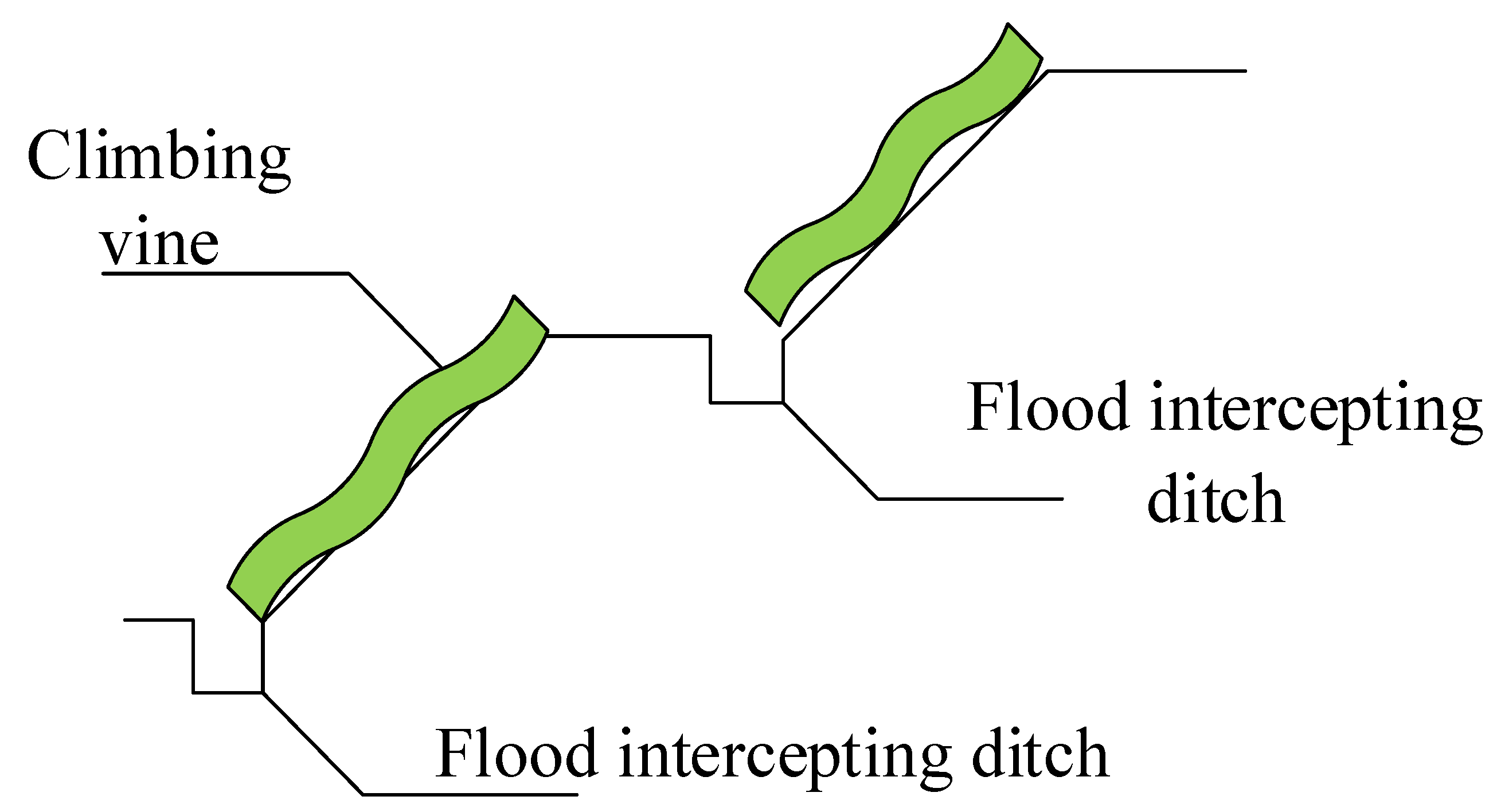 Figure 7 11 shows a cut edge slope protection greater than 30 m. The building retreat area is 95 m for slope protection with multiple retreats. A step-like low slope is formed step by step. Considering safety factors and preventing rain erosion, the slope should be controlled between 45° and 38°. In the end, a stepped low-steep slope with a slope angle greater than 65 degrees is selected to reduce rain damage to the slope.
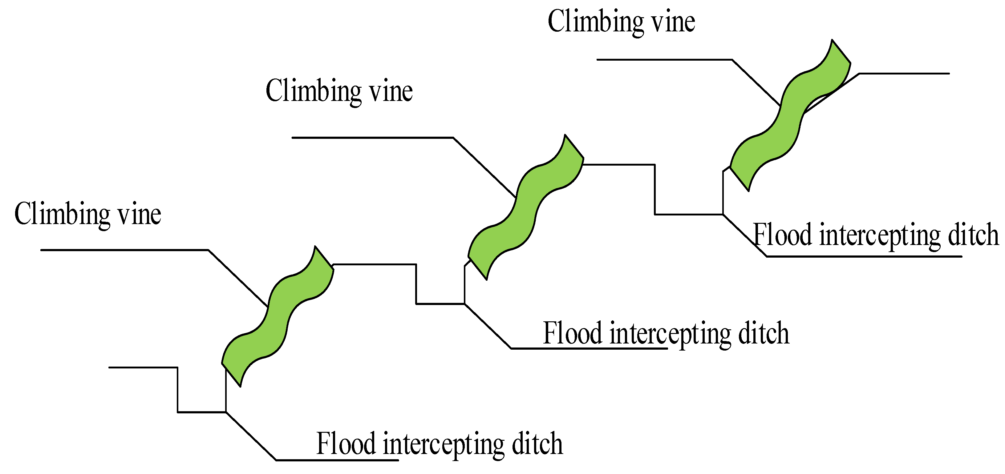
Figure 48. Design of slope protection.
Figure 59. Schematic diagram of protection measures for slopes less than 10 m in excavation.
Figure 610. Schematic diagram of protection measures for the 20–30 m side slope in excavation.
Figure 711. Schematic diagram of protection measures for slopes greater than 30 m in excavation.
In summary, slopes of different heights need to be protected in different ways. A slope greater than 30° needs to emphasize its safety and ecology. With a slope of less than 30° in consideration of safety and ecological conditions, the required activity area should be designed. The flood control ditch at the foot of the mountain must be set up. Meanwhile, to prevent the occurrence of flood disasters, rainwater collection, flood control, and other corresponding projects must be established.
2.3. Plan the Land Layout According to the Evaluation Results
Based on the above analysis and elaboration, with a scientific point of view and the rationality of construction as the starting point, the land construction plan for the planning new area is drawn. In accordance with the topographic characteristics of the northern New Area of Yan’an, the shape and form connected with form and meaning are finally formed. In general, the pattern still maintains the original continuity in the east–west direction. According to the plan of the land construction plan, the north and south will carry out the construction design according to the requirements. According to the concept of mountain management, city management, ecological stability, and safety first, the overall layout of the original ecological and economical, safe, and innovative landform planning is designed [18].
3. Conclusions
Herein uses the economics, physical geography, population distribution, and society of the planning new area as the starting point of the research. The research work selects the appropriate evaluation factors and corresponding evaluation indicators for proper mathematical modeling. The entire proposed analysis is quantified, and the evaluation of the suitability of the land forms an intuitive assumption, which benefits from the scientific use of GIS system. According to the current characteristics of the new area, the evaluation factors of the dominant factors in the planning new area are analyzed and evaluated. The multi-objective approach is used in this work for the evaluation of the suitability of land construction. The adaptability evaluation results of the study area are divided into three categories: suitable for construction, generally suitable for construction, and unsuitable for construction. The scale and layout of these three types of areas were qualitatively analyzed, respectively. This article significantly constructs and maximizes the planning of the new area, while analyzing the current situation of land use, conducting land-use evaluation, and proposing land-use construction strategies.
References
- Mondal, B.; Das, D.N. How residential compactness and attractiveness can be shaped by environmental amenities in an industrial city? Sustain. Cities Soc. 2018, 41, 363–377.
- Zellner, M.L.; Theis, T.L.; Karunanithi, A.T.; Garmestani, A.S.; Cabezas, H. A new framework for urban sus-tainability assessments: Linking complexity, information and policy. Comput. Environ. Urban Syst. 2008, 32, 474–488.
- Qiong, J.; Andrey, Z. Study on ecological evaluation of urban land based on GIS and RS technology. Arab. J. Geosci. 2021, 14, 1–8.
- Marcella, S.V.; Juan, P.M.D. City Logistics in historic centers: Multi-Criteria Evaluation in GIS for city of Salvador (Bahia–Brazil). Case Stud. Transp. Policy 2019, 7, 772–780.
- Qin, X.F.; Qin, P. Evaluation of the Suitability of Urban Construction Land—A Case Study of Hudai Town. Urban. Land Use 2019, 7, 1–10.
- Hoseini, Y.; Kamrani, M. Using a fuzzy logic decision system to optimize the land suitability evaluation for a sprinkler irrigation method. Outlook Agric. 2018, 47, 298–307.
- Hassan, I.; Javed, M.A.; Asif, M.; Luqman, M.; Ahmad, S.R.; Ahmad, A.; Akhtar, S.; Hussain, B. Weighted overlay based land suitability analysis of agriculture land in Azad Jammu and Kashmir using GIS and AHP. Pak. J. Agric. Sci. 2020, 57, 1509–1519.
- Silva-Gallegos, J.J.; Aguirre-Salado, C.A.; Miranda-Aragón, L.; Sánchez-Díaz, G.; Valdez-Lazalde, J.R.; Pedroza-Carneiro, J.W.; Flores-Cano, J.A. Locating potential zones for cultivating Stevia rebaudiana in Mexico: Weighted linear com-bination approach. Sugar Tech 2017, 19, 206–218.
- Bagherzadeh, A.; Gholizadeh, A. Modeling land suitability evaluation for wheat production by parametric and TOPSIS approaches using GIS, northeast of Iran. Model. Earth Syst. Environ. 2016, 2, 1–11.
- Bagherzadeh, A.; Ghadiri, E.; Darban, A.R.S.; Gholizadeh, A. Land suitability modeling by parametric-based neural networks and fuzzy methods for soybean production in a semi-arid region. Model. Earth Syst. Environ. 2016, 2, 104.
- Danvi, A.; Jütten, T.; Giertz, S.; Zwart, S.; Diekkrüger, B. A spatially explicit approach to assess the suitability for rice cultivation in an inland valley in central Benin. Agric. Water Manag. 2016, 177, 95–106.
- Deng, F.; Li, X.; Wang, H.; Zhang, M.; Li, R.; Li, X. GIS-based assessment of land suitability for alfalfa cultivation: A case study in the dry continental steppes of northern China. Span. J. Agric. Res. 2014, 12, 364–375.
- Estes, L.D.; Bradley, B.A.; Beukes, H.; Hole, D.G.; Lau, M.; Oppenheimer, M.G.; Schulze, R.; Tadross, M.A.; Turner, W.R. Comparing mechanistic and empirical model projections of crop suitability and productivity: Implications for ecological forecasting. Glob. Ecol. Biogeogr. 2013, 22, 1007–1018.
- López-Blanco, J.; Pérez-Damián, J.L.; Conde-Álvarez, A.C.; Gómez-Díaz, J.D.; Monterroso-Rivas, A.I. Land suitability levels for rainfed maize under current conditions and climate change projections in Mexico. Outlook Agric. 2018, 47, 181–191.
- Raza, S.M.H.; Mahmood, S.A.; Khan, A.A.; Liesenberg, V. Delineation of Potential Sites for Rice Cultivation Through Multi-Criteria Evaluation (MCE) Using Remote Sensing and GIS. Int. J. Plant Prod. 2017, 12, 1–11.
- Veselov, G.; Tselykh, A.; Sharma, A.; Huang, R. Applications of Artificial Intelligence in Evolution of Smart Cities and Societies. Informatica 2021, 45.
- Leroux, L.; Castets, M.; Baron, C.; Escorihuela, M.-J.; Bégué, A.; Seen, D.L. Maize yield estimation in West Africa from crop process-induced combinations of multi-domain remote sensing indices. Eur. J. Agron. 2019, 108, 11–26.
- Ruzikulova, O.; Sabitova, N.; Kholdorova, G. The role of GIS technology in determining irrigated geosystems. E3S Web Conf. 2021, 227, 03004.
- Hossain, M.; Masud, M. Evaluating software usability of geographic information system. Int. J. Comput. Internet Manag. 2009, 17, 37–54.
More