Natural, semi-natural, and planted forests are a key asset worldwide, providing a broad range of positive externalities. For sustainable forest planning and management, remote sensing (RS) platforms are rapidly going mainstream. In a framework where scientific production is growing exponentially, a systematic analysis of unmanned aerial vehicle (UAV)-based forestry research papers is of paramount importance to understand trends, overlaps and gaps.
- UAV
- drone
- forest
1. Introduction
Natural, semi-natural and planted forests are a key asset worldwide, providing a broad range of positive externalities. These kinds of benefits can be included in three main categories such as goods (timber, food, fuel, and bioproducts), ecosystem services (carbon storage, nutrient cycling, water, air quality, and wildlife habitat), and social and cultural features (recreation, traditional resource uses, and well-being) [1]. In this context, sustainable forest planning and management require understanding both short and long-term woodland dynamics [2]; furthermore, a modernization of forestry inventory frameworks is needed and driven by the ongoing uncertainty on the future condition of forests related to climate [3]. Ordinary inventory operations require the collection of field data with labor-intensive, time-consuming, and, no less important, increasingly expensive acquisition procedures. Besides, field campaigns are restricted to small areas, so that the number of field inventories that can be reasonably completed is drastically limited [2]. For the adoption of precision forestry practices, promptness is a key requirement and this is especially true when the forest structure is changing in a hardly predictable way due to pressure from biotic or abiotic factors [3].
Remote sensing (RS) platforms, such as unmanned aircraft systems (UAS), satellites, and airplanes fitted with dedicated sensors are rapidly going mainstream. They are still being developed for full optimization, among other sectors, of forest management and their relevance for decision support is growing crucially for forestry managers, entrepreneurs, and researchers [4]. RS provides data at different resolutions in terms of space, spectral band, and time allowing forest modeling under different conditions and for various management purposes (economic, monitoring, conservation, restoration). Unlike traditional field-based inventories, the full-coverage often guaranteed by RS platforms provides data on many primary forestry parameters [1]. Nevertheless, RS applications for forestry often require images with a high temporal resolution [5]. Considering the traditional airborne and spaceborne RS platforms, the spatial and temporal resolutions provided by satellite-based data are usually not suited to achieving regional or local forestry objectives while aircraft, even if their products have a more appropriate spatial scale, are expensive when regular time-series monitoring is desired [6]. Moreover, data from manned aircraft and satellite platforms are vulnerable to cloudy sky conditions, which attenuate electromagnetic waves and cause information loss and data degradation [7]. Drones (hereafter called Unmanned Aerial Vehicle—UAV), equipped with GPS and digital cameras, are suitable for real-time applications, inasmuch as they combine high spatial resolution and quick turnaround times with lower operational costs [8]. Thanks to their flexibility of use, UAVs are becoming one of the emergent technological tools, with a wide perspective, as well as increasing applicability [9] and therefore, for precision forestry application especially at a local scale, they overtake traditional RS platforms. It is also important to note that recent UAV advances, along with computer vision and other related research topics, have created many opportunities for practical forestry by facilitating and improving field data collection in terms of temporal and spatial accuracy, with the possibilities of creating customized datasets according to specific needs [10].
The major drawbacks in using UAVs rather than other RS platforms are represented by generic technical issues that are not related to the inner features of forests. To the best of the authors’ knowledge, only Surovỳ and Kuželka [10] report that the effective extent of detailed UAV data is limited to several forest stands because the high resolution and high-frequency data cannot be efficiently acquired for the whole extent of a very large forest. In general, the main disadvantages of UAV flights are imposed by battery duration and therefore by small area coverage, payload weight [11], and sensitivity to some bad weather conditions (i.e., wind, precipitation, and sudden and sharp light conditions variation) [4][12]. In the post-flight workflow, UAV imagery products involve massive data processing capability [1], often with a combination of robust image processing software and sophisticated machine learning systems; all this results in substantial computation requirements and therefore high expense in terms of money and time [13]. Current limitations for UAV activity are also enforced by policy and regulations (restrictions on airspace use). This is one of the major factors that prevent researchers from testing all of the possibilities for UAV civil applications [7]. Despite the critical issues listed, the advantages of using UAV instead of other RS platforms far outweigh the drawbacks. If used appropriately and combined with ground surveys and local knowledge, UAVs can constitute a valuable tool in monitoring and mapping forests, especially over small areas, responding to the growing need for more accurate data [14]. In the last years, UAVs have been recognized as an effective complement to traditional vehicles due to their economy, safety, maneuverability, positioning accuracy, high spatial resolution, and data acquisition on demand [5][7]. UAV imagery, due to its extremely high possible spatial resolution (fixed-wing up to 2 cm/pixel; rotary: sub-millimeter), is a cost-effective data source for providing detailed reference information [15], especially for a research project or service-based business with a tight budget. UAVs can carry a wide range of task-oriented sensors [16][17] whose operation is not affected by clouds due to the low flight altitude [4]. UAV missions can be planned flexibly, avoiding poor weather conditions, providing data availability on-demand, and enhancing temporal resolution [6]. The availability of UAV imagery in NRT (Near Real-Time) is another feature that can help agroforestry operations, due to the possibility of identifying problems faster and, consequently, reacting quickly, reducing losses, and, in the case of professional foresters, economic outlays [4]. UAVs can thus be used in real-time operations, for example in wildfire detection using thermal sensors [6]. Regarding academia, the use of UAV allows researchers to acquire complex imagery (i.e., hyperspectral) themselves and with higher frequency than in the past when specialized companies provided all the airborne imagery [10]. Furthermore, thanks also to the constant technological development, UAV costs in terms of material and operational charges are diminishing, while processing capabilities and dedicated artificial intelligence (AI) algorithms, i.e., machine learning, improve [13]. Finally, UAVs can save time, manpower, and financial resources for practitioners, public authorities, and researchers [6]. For all the aforementioned pros, interest in UAV has been increasing and this technology has become a focus of research [5].
2. UAV in Forest Remote Sensing: Research Topics, Vehicle Type, and Sensors
The use of smart and low-cost tools such as UAVs in precision forestry has increased exponentially in recent years, as demonstrated by the large number of papers published from 2018 until mid-2020; more than 600 references were found when searching for “UAV” + “forest” and considering articles, systematic reviews, conference proceedings and books [18]. By summarizing the results of some recent review papers [4][5][13][19], it follows that the range of UAV academic topics investigated by researchers is very wide and it also involves the use of UAV together with other RS platforms. Two main clusters among research topics can be outlined: (i) dendrometric parameters estimation (ii) monitoring and conservation activities. Regarding the estimation of basic physiological features, UAVs have been used with varying levels of success in 2D and 3D mapping applications such as individual tree detection or estimation of tree height, leaf area index (LAI), chlorophyll content, tree crown dimension, and location. In this cluster a subgroup of topics, regarding the estimation of derived dendrometric parameters, can be connected directly also with practical forestry activities: monitoring growth status, measuring plant density, merchantable biomass estimation, species identification, inspection of forestry operations, diseases detection and management, and post-harvest data (i.e., forest stockpiles measuring, truckload soil structure degradation). The second cluster includes the use of UAV for monitoring, conservation, and restoration activities required by the impact of climate change on forests and the change in the level of woodland biodiversity. In particular, UAVs are used, from an ecological point of view, for the mapping and control of weed vegetation and invasive alien species; deforestation monitoring and estimation of deforestation rates utilizing the identification of gaps; forest wildfire management and detection, especially for prevention and post-fire monitoring, by identifying and constructing risk maps and supporting shut down operations. UAV and their sensors are also applied to quantify aboveground biomass (AGB) and monitor it over time to assess the impacts of climate and land-use changes on the global carbon cycle of forest ecosystems and to understand their effects on woodland resilience and health. Furthermore, UAVs can track wildlife, detect woodland land-use change, monitor legal restrictions, and, in general, monitor habitats that are difficult to reach (wetlands, rock faces, coastal ecosystems) or where trespassing is undesirable [4][5][13][19].
UAVs employed for forestry applications and reviewed in this study are classified according to their size as small, mini, and micro vehicles and can also be categorized on the basis of wing type. Generally, in regard to civilian usage, UAVs can be rotor-based, fixed-wing, or can adopt hybrid solutions (
). They are user-friendly platforms with take-off mass ranging from a few tens of grams up to 25 kg and over [5] and with a flight time comprised between a couple of minutes and a few hours of autonomy [4]. Fixed-wing platforms are adequate for monitoring larger areas with a pre-defined flight plan but need space for landing [1]. On the other hand, multi-rotor UAVs are more maneuverable, having easier take-off and landing and are preferred by researchers because they are usually cheaper and more flexible for demonstrative/scientific studies [4].
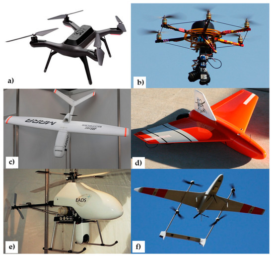
Unmanned aerial vehicle (UAV) types for remote sensing civilian usage: rotary-wing (
,
), fixed-wing (
,
), unmanned helicopter (
), and hybrid solution (
).
The progress in sensor implementation particularly concerned their miniaturization to lessen the payload to be transported. This big step forward has allowed us to equip the UAV with a broad range of sensors and tools: high-resolution digital cameras, infrared/thermal cameras, multi-spectral cameras (passive sensors), lidar—Laser Imaging Detection and Ranging (active sensors)—as well as chemical instrumentation for sensing Volatile Organic Compounds (VOCs) [20][21][22] and also tools for distributing agro-forestry products [23]. The possibility of equipping UAV with a wide choice of sensors in association with georeferencing systems has supported forestry scientific research by monitoring anomalies and trends which, if observed by traditional means from the ground, could have manifested in a less obvious way [24].
RS applications very often separate RGB channels and work with individual red, green, and blue channels to provide valuable visual information for foresters [25]. Instead, for assessing vegetation properties, information obtained in the NIR region (from 750 nm to approximately 1400 nm), where the high reflectance of vegetation occurs, should be used. Indeed, the NIR band results crucial for most forestry applications precisely because healthy vegetation that is actively growing and producing energy from photosynthesis reflects more in the NIR region [4]. Thermal cameras operate approximately in the spectrum at wavelengths from 8000 to 15,000 nm and detect electromagnetic radiation which can be experienced as heat. Thanks to these sensors, the pixel’s digital number can be transformed into a temperature measurement [26]. Multispectral sensors sense broadbands, usually 4–12, and are extensively used for vegetation analysis, given that they often include NIR together with multiple bands (e.g., R, G, B, red edge) [27]. The hyperspectral sensor is gradually becoming more common in UAV forestry applications. It has very high spectral resolutions sensing hundreds of narrow bands up to 2 nm in wavelength. Hyperspectral sensors produce images in which each pixel contains the whole spectrum of the sensed wavelengths. In this way, greater imagery information than all the other passive devices is provided [28] but a few drawbacks, such as high operation costs and complex equipment are inevitable with today’s technology [13]. Lidar is an active laser-based remote-sensing technology that uses focused laser light pulses by transmitting them to the surface with a fast repeat rate. It measures the time taken for the reflections to be detected by the sensor (transmitter-target-receptor) to determine the distance to targets (objects, surface). By repeating this process with a fast sequence, lidar generates a 3D point cloud of the surface [4][13].
Regarding the use of UAV sensors in forestry applications, it can be emphasized how the RGB sensors are suitable to estimate Fractional Vegetation Cover (FVC) [29], to find features within a certain area (e.g., tree crown size estimation) [30], and to detect invasive species [31]. Instead, through reflectance analysis with wavebands outside of the visible spectrum, the multispectral, infrared, and hyperspectral sensors are most suitable for LAI [32] and for identifying the presence/absence of certain components or materials (e.g., disease [33][34] and water stress detection [35]). Thermal sensors are used effectively to detect water stress [36] and in forest fire monitoring [37] and wildlife detection [38] while multispectral sensors can be applied for determining burned areas in a post-fire scenario [39]. Lidar sensors can provide accurate measurements targeting land objects for an effective forest inventory, also being capable of gathering data also below the canopy [40]. By penetrating the forest canopy, lidar is a powerful tool for the direct 3D measurement of various tree attributes, even at a fine-grained scale [41]. It can be used for individual tree detection and crown delineation [42][43][44], for retrieving inventory parameters such as diameter [45], height [46] and biomass [47] and for predicting carbon dynamics [48]. Lidar metrics are both ecologically meaningful and management-relevant, as demonstrated by their applications in overstory characterization [49], forest restoration [50], wildfire prevention [51] and post-fire monitoring [52]. Nevertheless, a careful comparison must always be made with optical sensors considering the relatively high cost of lidar technology [53][54]. For instance, to determine vegetation height, optical sensors are a plausible choice, because they offer the possibility of image 3D reconstruction using Structure from Motion (SfM) algorithms and, at the same time, they have higher cost-effectiveness compared to lidar [4].
3. Unmanned Aerial Vehicle Forest Remote Sensing
Forests, but also other natural resources, need monitoring, management, and preservation, which increasingly profit from UAV remote sensing. As a rule, the capabilities of UAS are evaluated in terms of spectral, spatial and temporal resolution, as well as processing time, area coverage and cost-efficiency. When the monitored woodland has a quite small area, the use of drones is surely advantageous for the amplitude and precision in the acquisition of the spectral range, the centimetric resolution, and daily monitoring frequency. Conversely, among the main drawbacks of UAV compared to other RS platforms may be cited processing time (i.e., about ten times greater than that of a satellite) [55], inability to survey large areas due to the battery and regulatory limitations, and the lack of consistent data collection and processing workflows for multitemporal analysis [56].
The results presented in this Part I show how forestry RS is expanding exponentially. The growth is witnessed by the increased number of scientific papers (also in the short timespan analyzed) and by several journals belonging to different scientific publishers. From scientific mapping, it emerges that the research issues are mainly heading towards the estimation of inventory parameters among which AGB stands out for importance; at a methodological level, researchers look expectantly at the use of UAV-DAP and machine learning techniques for tree identification and classification purposes. The screened papers cover both natural and planted forests composed of coniferous, broadleaved, or mixed species. Researchers make use of a wide range of UAV-mounted sensors (passive and active); in this context, the RGB camera with centimetric resolution now seems a consolidated and mature technology.
Despite all this, there are several critical issues that the academic world must address to further improve the general quality of research in UAV forest remote sensing as also revealed by the scientific mapping of the most frequent keywords. This review highlights that the number of papers in some continents is often inversely proportional to their huge forest heritage: the case of Africa is striking (only five studies published), but also South America has a quite small number of researches. In parallel, tropical and equatorial forests (representing about 30% of emerged land areas) are under-represented biomes, with only <14% of studies. Remote sensing methods represent a powerful tool for investigating spatial and temporal patterns of vegetation in these challenging environments; this is especially true for low-flying UAV imagery which is not affected by atmospheric artifacts from highly seasonal cloud cover and aerosol loads [57]. The resulting lack of knowledge about tropical and equatorial woodland could perhaps be ascribed to the geographic distribution of research centers, which are often located in developed countries, but also to UAV’s limited flight range associated with the inaccessibility of tropical forests that make these ecosystems technically hard to monitor, as long as BVLOS (Beyond Visual Line of Sight) flight strategy will be authorized. Besides, in this context, the availability of ready-to-fly UAV platforms at affordable prices seems to be too recent and it might not allow end-users from developing countries to perform image acquisition with a simpler tool in comparison to customized ones. In the case of UAV, it is difficult to suggest a possible solution through open data accessibility to potential end-users, as in the case of some satellite platforms. As stated by Huylenbroeck et al. [58], using the RS tools to monitor natural resources is not neutral: these methods could exclude stakeholders who do not have access to the technology.
Hyperspectral sensors certainly represent a promising tool for future RS progress but, in this review, less than 10% of papers were found to utilize the technology. This could be due to the difficulties in calibration and setting of prototype/customized solutions, in addition to the high market prices of commercially available packages. In this sense, the ongoing cost reduction of off-the-shelf hyperspectral cameras could certainly boost the use of the sensor. By exploiting the ability to choose numerous bands in a precise spectral range, UAV-mounted hyperspectral cameras can provide the tree spectral signature that, in turn, could be used for species recognition or disease detection.
The capability of acquiring UAV images with high frequency provides new opportunities to study forest evolution. Although UAVs can easily acquire a dense time series, only a few research papers deal with the central issue of multi-temporality to describe vegetation dynamics. Multi-temporal analysis can sometimes replace the spectral range, as in some studies where UAV time series are mainly exploited for intra-annual application such as phenology monitoring. Other papers compare single-season UAV imagery products with relatively coarse resolution satellite images. Less than 1% of research works gather multi-seasonal UAV data; in particular, a three-year UAV image time series is used both for species identification in a Brazilian Atlantic forest [59] and chestnut health monitoring [60]. The poor use of UAV-acquired image time series is an issue that must certainly be addressed by future research. Doing this, it is of pivotal importance to find a balance among the size of the remote-sensed area, spatial and temporal resolution without running into the drawbacks of field surveys again (i.e., high cost and labor).
Finally, although the legal situation of UAV flying is analyzed quite recently [61], none of the selected papers tackle this issue. Many countries still lack legislation that regulates the use of UAV both for research and commercial purposes. Some authors [4][62] highlight the importance of integrating as soon as possible UAV in the airspace through a specific regulatory regime. The legislative framework should be concerted by all the stakeholders to realize UAS’s full potential and increase its usage while ensuring individual citizens’ safety and privacy rights. A debate on conditions under which drones can be operated is required where this is lacking (i.e., within the European Union) or in specific situations where human artifacts could raise some concerns (i.e., agroforestry, the riparian ecosystem in developed countries). In the end, UAV regulations should be improved addressing not only forestry monitoring but also innovative uses such as management operations including, for instance, chemical distribution.
References
- Gómez, C.; Alejandro, P.; Hermosilla, T.; Montes, F.; Pascual, C.; Ruiz, L.Á.; Álvarez-Taboada, F.; Tanase, M.A.; Valbuena, R. Remote sensing for the Spanish forests in the 21st century: A review of advances, needs, and opportunities. For. Syst. 2019, 28, 1–33.
- Goodbody, T.R.H.; Coops, N.C.; White, J.C. Digital Aerial Photogrammetry for Updating Area-Based Forest Inventories: A Review of Opportunities, Challenges, and Future Directions. Curr. For. Rep. 2019, 55–75.
- Iglhaut, J.; Cabo, C.; Puliti, S.; Piermattei, L.; O’Connor, J.; Rosette, J. Structure from Motion Photogrammetry in Forestry: A Review. Curr. For. Rep. 2019, 5, 155–168.
- Pádua, L.; Vanko, J.; Hruška, J.; Adão, T.; Sousa, J.J.; Peres, E.; Morais, R. UAS, sensors, and data processing in agroforestry: A review towards practical applications. Int. J. Remote Sens. 2017, 38, 2349–2391.
- Raparelli, E.; Bajocco, S. A bibliometric analysis on the use of unmanned aerial vehicles in agricultural and forestry studies. Int. J. Remote Sens. 2019, 40, 9070–9083.
- Guimarães, N.; Pádua, L.; Marques, P.; Silva, N.; Peres, E.; Sousa, J.J. Forestry remote sensing from unmanned aerial vehicles: A review focusing on the data, processing and potentialities. Remote Sens. 2020, 12, 1046.
- Xiang, T.Z.; Xia, G.S.; Zhang, L. Mini-Unmanned Aerial Vehicle-Based Remote Sensing: Techniques, applications, and prospects. IEEE Geosci. Remote Sens. Mag. 2019, 7, 29–63.
- Chianucci, F.; Disperati, L.; Guzzi, D.; Bianchini, D.; Nardino, V.; Lastri, C.; Rindinella, A.; Corona, P. Estimation of canopy attributes in beech forests using true colour digital images from a small fixed-wing UAV. Int. J. Appl. Earth Obs. Geoinf. 2016, 47, 60–68.
- De Rango, F.; Palmieri, N.; Santamaria, A.F.; Potrino, G. A simulator for UAVs management in agriculture domain. Simul. Ser. 2017, 49, 149–156.
- Surovỳ, P.; Kuželka, K. Acquisition of forest attributes for decision support at the forest enterprise level using remote-sensing techniques—A review. Forests 2019, 10, 273.
- Manfreda, S.; McCabe, M.F.; Miller, P.E.; Lucas, R.; Madrigal, V.P.; Mallinis, G.; Dor, E.B.; Helman, D.; Estes, L.; Ciraolo, G.; et al. On the use of unmanned aerial systems for environmental monitoring. Remote Sens. 2018, 10, 641.
- Hakala, T.; Honkavaara, E.; Saari, H.; Mäkynen, J.; Kaivosoja, J.; Pesonen, L.; Pölönen, I. Spectral Imaging From Uavs Under Varying Illumination Conditions. ISPRS Int. Arch. Photogramm. Remote Sens. Spat. Inf. Sci. 2013, XL-1/W2, 189–194.
- Zimudzi, E.; Sanders, I.; Rollings, N.; Omlin, C.W. Remote sensing of mangroves using unmanned aerial vehicles: Current state and future directions. J. Spat. Sci. 2019, 1–18.
- Senthilnath, J.; Kandukuri, M.; Dokania, A.; Ramesh, K.N. Application of UAV imaging platform for vegetation analysis based on spectral-spatial methods. Comput. Electron. Agric. 2017, 140, 8–24.
- Chen, Q.; Kutser, T.; Collin, A.; Warner, T.A. Fine resolution remote sensing of species in terrestrial and coastal ecosystems. Int. J. Remote Sens. 2018, 39, 5597–5599.
- Shakhatreh, H.; Sawalmeh, A.; Al-Fuqaha, A.; Dou, Z.; Almaita, E.; Khalil, I.; Othman, N.S.; Khreishah, A.; Guizani, M. Unmanned aerial vehicles: A survey on civil applications and key research challenges. IEEE Access 2019, 7, 48572–48634.
- Dunford, R.; Michel, K.; Gagnage, M.; Piégay, H.; Trémelo, M.-L. Potential and constraints of Unmanned Aerial Vehicle technology for the characterization of Mediterranean riparian forest. Int. J. Remote Sens. 2009, 30, 4915–4935.
- Web of Science [v.5.35]—Web of Science Core Collection Basic Search. Available online: (accessed on 8 January 2021).
- Poley, L.G.; McDermid, G.J. A systematic review of the factors influencing the estimation of vegetation aboveground biomass using unmanned aerial systems. Remote Sens. 2020, 12, 1052.
- Batista, C.E.; Ye, J.; Ribeiro, I.O.; Guimarães, P.C.; Medeiros, A.S.S.; Barbosa, R.G.; Oliveira, R.L.; Duvoisin, S.; Jardine, K.J.; Gu, D.; et al. Intermediate-scale horizontal isoprene concentrations in the near-canopy forest atmosphere and implications for emission heterogeneity. Proc. Natl. Acad. Sci. USA 2019, 116, 19318–19323.
- Mckinney, K.A.; Wang, D.; Ye, J.; Fouchier, J.B.D.; Guimarães, P.C.; Batista, C.E.; Souza, R.A.F.; Alves, E.G.; Gu, D.; Guenther, A.B.; et al. A sampler for atmospheric volatile organic compounds by copter unmanned aerial vehicles. Atmos. Meas. Tech. 2019, 12, 3123–3135.
- Chen, J.; Scircle, A.; Black, O.; Cizdziel, J.V.; Watson, N.; Wevill, D.; Zhou, Y.; Batista, C.E.; Ye, J.; Ribeiro, I.O.; et al. On the use of multicopters for sampling and analysis of volatile organic compounds in the air by adsorption/thermal desorption GC-MS. Air Qual. Atmos. Health 2019, 116, 835–842.
- Katsigiannis, P.; Misopolinos, L.; Liakopoulos, V.; Alexandridis, T.K.; Zalidis, G. An Autonomous Multi-Sensor UAV System for Reduced-Input Precision Agriculture Applications. In Proceedings of the 2016 24th Mediterranean Conference on Control and Automation (MED), Athens, Greece, 21–24 June 2016; pp. 60–64.
- Nebiker, S.; Lack, N. Multispectral and thermal sensors on UAVs. GIM Int. 2016, 30, 19–21.
- Nebiker, S.; Annen, A.; Scherrer, M.; Oesch, D. A light-weight multispectral sensor for micro uav-opportunities for very high resolution airborne remote sensing. Int. Arch. Photogramm. Remote Sens. Spat. Inf. Sci. ISPRS Arch. 2008, 37, 1193–1199.
- Mejias, L.; Lai, J.; Bruggemann, T. Sensors for Missions BT—Handbook of Unmanned Aerial Vehicles; Valavanis, K.P., Vachtsevanos, G.J., Eds.; Springer: Dordrecht, The Netherlands, 2015; pp. 385–399.
- Colomina, I.; Molina, P. Unmanned Aerial Systems for Photogrammetry and Remote Sensing: A Review. ISPRS J. Photogramm. Remote Sens. 2014, 92, 79–97.
- Bendig, J.V. Unmanned Aerial Vehicles (UAVs) for Multi-Temporal Crop Surface Modelling—A New Method for Plant Height and Biomass Estimation Based on RGB-Imaging. Doctoral Thesis, Universität zu Köln, Cologne, Germany, 2015.
- Riihimäki, H.; Luoto, M.; Heiskanen, J. Estimating fractional cover of tundra vegetation at multiple scales using unmanned aerial systems and optical satellite data. Remote Sens. Environ. 2019, 224, 119–132.
- Shashkov, M.; Ivanova, N.; Shanin, V.; Grabarnik, P. Ground Surveys Versus UAV Photography: The Comparison of Two Tree Crown Mapping Techniques. In Proceedings of the Information Technologies in the Research of Biodiversity; Bychkov, I., Voronin, V., Eds.; Springer International Publishing: Cham, Switzerland, 2019; pp. 48–56.
- Casapia, X.T.; Falen, L.; Bartholomeus, H.; Cárdenas, R.; Flores, G.; Herold, M.; Coronado, E.N.H.; Baker, T.R. Identifying and quantifying the abundance of economically important palms in tropical moist forest using UAV imagery. Remote Sens. 2020, 12, 9.
- Guo, X.; Wang, L.; Tian, J.; Yin, D.; Shi, C.; Nie, S. Vegetation horizontal occlusion index (VHOI) from TLS and UAV image to better measure mangrove LAI. Remote Sens. 2018, 10, 1739.
- Zhang, N.; Zhang, X.; Yang, G.; Zhu, C.; Huo, L.; Feng, H. Assessment of defoliation during the Dendrolimus tabulaeformis Tsai et Liu disaster outbreak using UAV-based hyperspectral images. Remote Sens. Environ. 2018, 217, 323–339.
- Cardil, A.; Otsu, K.; Pla, M.; Silva, C.A.; Brotons, L. Quantifying pine processionary moth defoliation in a pine-oak mixed forest using unmanned aerial systems and multispectral imagery. PLoS ONE 2019, 14, e0213027.
- Zhao, T.; Stark, B.; Chen, Y.Q.; Ray, A.L.; Doll, D. Challenges in Water Stress Quantification Using Small Unmanned Aerial System (sUAS): Lessons from a Growing Season of Almond. J. Intell. Robot. Syst. Theory Appl. 2017, 88, 721–735.
- Zarco-Tejada, P.J.; González-Dugo, V.; Berni, J.A.J. Fluorescence, temperature and narrow-band indices acquired from a UAV platform for water stress detection using a micro-hyperspectral imager and a thermal camera. Remote Sens. Environ. 2012, 117, 322–337.
- Kinaneva, D.; Hristov, G.; Raychev, J.; Zahariev, P. Early forest fire detection using drones and artificial intelligence. In Proceedings of the 2019 42nd International Convention on Information and Communication Technology, Electronics and Microelectronics (MIPRO), Opatija, Croatia, 20–24 May 2019; pp. 1060–1065.
- Witczuk, J.; Pagacz, S.; Zmarz, A.; Cypel, M. Exploring the feasibility of unmanned aerial vehicles and thermal imaging for ungulate surveys in forests—Preliminary results. Int. J. Remote Sens. 2018, 39, 5504–5521.
- Shin, J.I.; Seo, W.W.; Kim, T.; Park, J.; Woo, C.S. Using UAV multispectral images for classification of forest burn severity—A case study of the 2019 Gangneung forest fire. Forests 2019, 10, 1025.
- Hyyppä, E.; Hyyppä, J.; Hakala, T.; Kukko, A.; Wulder, M.A.; White, J.C.; Pyörälä, J.; Yu, X.; Wang, Y.; Virtanen, J.P.; et al. Under-canopy UAV laser scanning for accurate forest field measurements. ISPRS J. Photogramm. Remote Sens. 2020, 164, 41–60.
- Lefsky, M.A.; Cohen, W.B.; Parker, G.G.; Harding, D.J. Lidar Remote Sensing for Ecosystem Studies: Lidar, an Emerging Remote Sensing Technology That Directly Measures the Three-Dimensional Distribution of Plant Canopies, Can Accurately Estimate Vegetation Structural Attributes and Should Be of Particular Interest to Forest, Landscape, and Global Ecologists; Oxford Academic: Oxford, UK, 2002; p. 52.
- Hu, B.; Li, J.; Jing, L.; Judah, A. Improving the efficiency and accuracy of individual tree crowndelineation from high-density LiDAR data. Int. J. Appl. Earth Obs. Geoinf. 2014, 26, 145–155.
- Wu, B.; Yu, B.; Wu, Q.; Huang, Y.; Chen, Z.; Wu, J. Individual tree crown delineation using localized contour tree method and airborne LiDAR data in coniferous forests. Int. J. Appl. Earth Obs. Geoinf. 2016, 52, 82–94.
- Jeronimo, S.M.A.; Kane, V.R.; Churchill, D.J.; McGaughey, R.J.; Franklin, J.F. Applying LiDAR Individual Tree Detection to Management of Structurally Diverse Forest Landscapes. J. For. 2018, 116, 336–346.
- Kuželka, K.; Slavík, M.; Surový, P. Very high density point clouds from UAV laser scanning for automatic tree stem detection and direct diameter measurement. Remote Sens. 2020, 12, 1236.
- Yin, D.; Wang, L. Individual mangrove tree measurement using UAV-based LiDAR data: Possibilities and challenges. Remote Sens. Environ. 2019, 223, 34–49.
- D’Oliveira, M.V.N.; Broadbent, E.N.; Oliveira, L.C.; Almeida, D.R.A.; Papa, D.A.; Ferreira, M.E.; Zambrano, A.M.A.; Silva, C.A.; Avino, F.S.; Prata, G.A.; et al. Aboveground biomass estimation in Amazonian tropical forests: A comparison of aircraft-and gatoreye UAV-borne LIDAR data in the Chico mendes extractive reserve in Acre, Brazil. Remote Sens. 2020, 12, 1754.
- Stark, S.C.; Leitold, V.; Wu, J.L.; Hunter, M.O.; de Castilho, C.V.; Costa, F.R.C.; McMahon, S.M.; Parker, G.G.; Shimabukuro, M.T.; Lefsky, M.A.; et al. Amazon forest carbon dynamics predicted by profiles of canopy leaf area and light environment. Ecol. Lett. 2012, 15, 1406–1414.
- Wiggins, H.L.; Nelson, C.R.; Larson, A.J.; Safford, H.D. Using LiDAR to develop high-resolution reference models of forest structure and spatial pattern. For. Ecol. Manag. 2019, 434, 318–330.
- Almeida, D.R.A.; Broadbent, E.N.; Zambrano, A.M.A.; Wilkinson, B.E.; Ferreira, M.E.; Chazdon, R.; Meli, P.; Gorgens, E.B.; Silva, C.A.; Stark, S.C.; et al. Monitoring the structure of forest restoration plantations with a drone-lidar system. Int. J. Appl. Earth Obs. Geoinf. 2019, 79, 192–198.
- Fernández-álvarez, M.; Armesto, J.; Picos, J. LiDAR-based wildfire prevention in WUI: The automatic detection, measurement and evaluation of forest fuels. Forests 2019, 10, 148.
- Viedma, O.; Almeida, D.R.A.; Moreno, J.M. Postfire Tree Structure from High-Resolution LiDAR and RBR Sentinel 2A Fire Severity Metrics in a Pinus halepensis-Dominated Burned Stand. Remote Sens. 2020, 12, 3554.
- Cao, L.; Liu, H.; Fu, X.; Zhang, Z.; Shen, X.; Ruan, H. Comparison of UAV LiDAR and digital aerial photogrammetry point clouds for estimating forest structural attributes in subtropical planted forests. Forests 2019, 10, 145.
- Ganz, S.; Käber, Y.; Adler, P. Measuring tree height with remote sensing—A comparison of photogrammetric and LiDAR data with different field measurements. Forests 2019, 10, 694.
- Ruwaimana, M.; Satyanarayana, B.; Otero, V.; Muslim, A.M.; Muhammad Syafiq, A.; Ibrahim, S.; Raymaekers, D.; Koedam, N.; Dahdouh-Guebas, F. The advantages of using drones over space-borne imagery in the mapping of mangrove forests. PLoS ONE 2018, 13, e0200288.
- Matese, A.; Toscano, P.; Di Gennaro, S.F.; Genesio, L.; Vaccari, F.P.; Primicerio, J.; Belli, C.; Zaldei, A.; Bianconi, R.; Gioli, B. Intercomparison of UAV, aircraft and satellite remote sensing platforms for precision viticulture. Remote Sens. 2015, 7, 2971–2990.
- Huete, A.R.; Saleska, S.R. Remote sensing of tropical forest phenology: Issues and controversies. Int. Arch. Photogramm. Remote Sens. Spat. Inf. Sci. ISPRS Arch. 2010, 38, 539–541.
- Huylenbroeck, L.; Laslier, M.; Dufour, S.; Georges, B.; Lejeune, P.; Michez, A. Using remote sensing to characterize riparian vegetation: A review of available tools and perspectives for managers. J. Environ. Manag. 2020, 267, 110652.
- Miyoshi, G.T.; Imai, N.N.; Tommaselli, A.M.G.; de Moraes, M.V.A.; Honkavaara, E. Evaluation of hyperspectral multitemporal information to improve tree species identification in the highly diverse atlantic forest. Remote Sens. 2020, 12, 244.
- Pádua, L.; Hruška, J.; Bessa, J.; Adão, T.; Martins, L.M.; Gonçalves, J.A.; Peres, E.; Sousa, A.M.R.; Castro, J.P.; Sousa, J.J. Multi-temporal analysis of forestry and coastal environments using UASs. Remote Sens. 2018, 10, 24.
- Cracknell, A.P. UAVs: Regulations and law enforcement. Int. J. Remote Sens. 2017, 38, 3054–3067.
- Greenwood, F. Drones on the horizon: New frontier in agricutural innovation. ICT Update 2016, 82, 2–4.