The Cenozoic Malaguide Basin from Sierra Espuña (Internal Betic Zone, S Spain) due to the qual-ity of outcropping, areal representation, and continuity in the sedimentation can be considered a key-basin. In the last 30 years, a large number of studies with very different methodological ap-proaches have been done in the area. Models indicate an evolution from passive margin to wedge-top basin from Late Cretaceous to Early Miocene. Sedimentation changes from limestone platforms with scarce terrigenous inputs, during the Paleocene to Early Oligocene, to the deep ba-sin with huge supplies of turbidite sandstones and conglomerates during the Late Oligocene to Early Miocene. The area now appears structured as an antiformal stack with evidence of synsedimentary tectonics.
- Sierra Espuña
- Cenozoic
- wedge-top basin
- tectono-
Note: The following contents are extract from your paper. The entry will be online only after author check and submit it.
1. Introduction
The Sierra Espuña area is located in the Murcia province in SE Spain (Figure 1A,B). The area is located around the towns of Alhama de Murcia and Totana, to the south, Pliego, in the center, and Mula, to the north (Figure 1A).
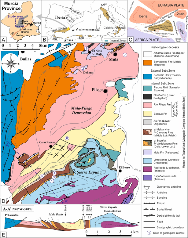
Figure 1. Geographical and geological location of the Sierra Espuña area (modified from [1]). (A) Geographic locations in the Murcia province (SE Spain). (B) Geographic location in the framework of the western Mediterranean alpine chains. (C) Paleogeographic sketch in Cretaceous times of the western Mediterranean area. (D) Geological map of the Sierra Espuña area including Sierra Espuña s.s. and the Mula-Pliego Depression. (E) Geological cross-section of the area located in Figure 1D. The location of the sites of geological interest appears in Figure 1D.
This area belongs to the Malaguide Complex from the Internal Betic Cordillera [2,3] [2][3]. The Internal Zone of this cordillera usually shows metamorphic rocks (Nevado-Filabride and Alpujarride complexes) and only the Malaguide Complex shows a sedimentary (or epimetamorphic) basement and cover. The Betic Cordillera belongs to the Alpine chains of the western Mediterranean area (Figure 1B) and formed during the Cretaceous to Miocene in response to continental collisions between the Mesomediterranean Microplate and the Iberia-Europe and Africa plates. This led to the closure of seaways and subductions in the western Tethys (Figure 1C) [4–11][4][5][6][7][8][9][10][11].
The area exhibits the Mesozoic-Cenozoic cover from the Malaguide Complex, structured in an antiformal stack [2[12][13][14],12–14], in the southern part (Sierra Espuña s.s.). This is followed to the north by a synclinorium (Mula-Pliego Depression) with minor structural highs related to fold-thrust (Figure 1D,E). The whole area consists of metamorphic (the lower units from the Alpujarride Complex) and sedimentary rocks (the upper two from the Malaguide Complex: Morrón de Totana and Perona units) ranging from the Paleozoic to the Miocene (Figure 1B). The area has outcrops of good quality and a quite continuous sedimentary record from the Cenozoic succession so that a large number of papers have been published in the area in the last three decades (see below). In particular, the Paleocene to Early Miocene tectono-sedimentary evolution has been the subject of numerous research papers making this basin a key-site for understanding the Cenozoic tectonostratigraphic of the region.
This paper has two scientific focuses: (1) the reviewing of the knowledge of the area, in general, and the Cenozoic, in particular; (2) the proposal of this Cenozoic record as geological heritage. So, this paper aims to show the Cenozoic tectono-sedimentary evolution of the Sierra Espuña as a key area and propose it as a geological heritage. This fact is already mentioned in the previous literature [2,3], and references therein) where the quality of outcropping of this tectonic complex from the Internal Betic Zone, is highlighted. To do this, eight sites of geological interest have been selected and evaluated according to recent methodologies [15,16][15][16].
2. Backgrounds
Former studies in the area were carried out by [17–27][17][18][19][20][21][22][23][24][25][26][27]. These works introduced the “nappe tectonics” concepts in the area. The involved units were defined and the main structural features of the nappes were established. These studies also proposed a basic stratigraphy and the approximate ages of the sedimentary record.
Studied of the Cenozoic Malaguide Basin in the Sierra Espuña area revived in the late nineties by [28] and related papers providing new insight into the structure and stratigraphy of the Cenozoic sediments of the area. These papers addressed the timing of deformation in the area, the stratigraphy of Cenozoic formations, and the structure of the Cenozoic sediments [29]. Detailed works were performed on the early Oligocene As Fm related to the beginning of Cenozoic deformation in the area [30] and the Paleocene Mula Fm of the Malaguide Complex [31].
More recent papers related to the structure and/or tectono-sedimentary evolution of the area include [5,6,11,12,32][32]. They redefine the cartographic boundaries, stratigraphy and direction of emplacement of the tectonic units. These authors classified the Cenozoic Malaguide basin of Sierra Espuña as a piggy-back.
The mineralogy and petrography of Cenozoic formations were described by [2] [2]. Most recently, the Paleocene-Early Eocene platform deposits of the Sierra Espuña area have been recently studied by [1].
Some books and papers have also been published about the area in recent times highlighting the geological heritage of the area and presenting it to the general public [33–35][33][34][35]. These works pointed out some sites of geological interest and georoutes in the area but no evaluation was performed.
3. Stratigraphic Framework of the Cenozoic Malaguide Basin from Sierra Espuña
According to literature, the Cenozoic of the Malaguide Complex in the Sierra Espuña area comprises nine stratigraphic formations arranged into two main sedimentary cycles (Figure 2): the lower one (Paleocene to Earliest Oligocene) is considered pre-orogenic since it is deposited before the older thrusts affecting the Malaguide Complex reached the surface. Nevertheless, flexural tectonics due to basement folding took place during this cycle. The upper cycle (Late Oligocene to Burdigalian) is considered syn-orogenic and deposited contemporaneously to the thin-skin thrusting tectonics which affected the entire Internal Betic Zone.
The pre-orogenic cycle includes six stratigraphic formations separated by lateral changes or unconformities (Figures 1,2). The older is the Mula Fm (Paleocene) consisting of marine carbonate platform and continental deposits and is separated from the underlying Upper Cretaceous deep marine Capas Blancas Fm by an erosional unconformity with a minor hiatus affecting the Upper Cretaceous p.p. The Mula Fm is separated from the overlying formations by a stratigraphic gap (unconformity and temporal hiatus) representing the Lower Ypresian (Ilerdian). Following this gap is the Cuisian to Lower Lutetian Espuña Fm, representing an alveoloine-Nummelite platform, and its proximal lateral equivalent, the Valdeparra Fm, consisting of lagoon- and marsh-deposits with coal). The top of both formations is a new erosive contact with minor hiatus associated. It separates the overlying Middle Lutetian to Upper Bartonian alveoline-Nummelites internal platform deposits of the Malvariche Fm. The latter (interfingers) into the marly Nummulite external platform deposits belonging to the Cánovas Fm (Lower Bartonian-Priabonian). The Canovas is unconformably overlain by the Lower Rupelian As Fm, consisting of marshy-lagoonal and deltaic deposits (with quartzite rounded pebbles). The syn-orogenic cycle includes three units (deposited in a syn-tectonic setting) (Figures 1,2). The Upper Oligocene to Aquitanian Bosque Fm consists of deltaic conglomerate, and limestone to marly platform deposits, which are separated from the underlying As Fm by an erosive unconformity. The Bosque Fm fingers laterally into, and is overlain by turbidites of the Rio Pliego, which in turn are overlain by the Burdigalian deep marine marls, turbidites and silexites of the El Niño Fm. The latter predates the Internal-External Zone Boundary suture [31]; the back thrusting of the External over the Internal Zone marks the end of the Cenozoic Malaguide Basin.
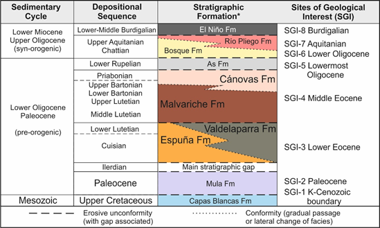
Figure 2. Stratigraphic framework with the chronostratigraphic range of Cenozoic formations of the Malaguide basin from Sierra Espuña (modified from [1]).
4. Tectono-Sedimentary Evolution of the Cenozoic Malaguide Basin from Sierra
Espuña
The study area is made up of several Malaguide tectonic units (nappes) divided into lower units (mainly metamorphosed) and upper units (with a sedimentary character) (Figure 1D). The upper tectonic units are two: the Morrón de Totana unit, in the lower position, and the Perona unit, in the upper position (Figures 1D and 3). In turn, the Malaguide units (both lower and upper ones) are thrusting to the Alpujarride tectonic units (in the middle position in the pile of nappes of the Internal Betic Zone). The Cenozoic geodynamic framework of the study area was very complex and marked by different structural stages [2,6,13] that strongly influenced the evolution and sedimentation of the basin. During this period, convergence took place between the Internal Betic Units (belonging to the western and southern margin of the Mesomediterranean Microplate) and the External Betic Units (belonging to the Iberian plate) as represented in Figure 1C. The convergence started in the Latest Cretaceous, and progressed until the Eocene-Oligocene boundary with the superposition of the Malaguide tectonic units over the lower Alpujarride tectonic units from the Internal Zone (Figure 3A) [6,13]. Later a second superposition stage took place in the Middle Oligocene. In this case, the upper Malaguide Perona unit was up-thrusted over the Morron de Totana one (Figure 3B), generating related structures in the southern studied area as the Espuña fold. During the Burdigalian, the westward displacement of the Internal Betic Zone and collision against the External Zones probably caused the rotation of the units located along with the Internal–External Zone contact [6].
The Cenozoic of this area was arranged into two main sedimentary cycles [6,8]). The older is: Paleocene to Earliest Oligocene (preorogenic) and deposited contemporaneously to the deep tectonics (Figure 3A). The younger is Late Oligocene to Burdigalian (syn-orogenic) and deposited contemporaneously to the progression of thrustings in thin skin tectonics affecting the entire Internal Betic Zone (Figure 3B).
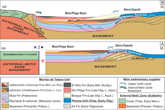
Figure 3. Interpretative tectono-sedimentary cross-sections of the Malaguide Basin from Sierra Espuña (modified from [1]). (A) Preorogenic Cycle (Paleocene-Earliest Oligocene). (B) Syn-orogenic Cycle (Late Oligocene-Early Miocene).
This division is accepted (with minor variation in the age) and equivalent for the Central-Western Alpine Chains (Apennines, Rif, Tell, and Betics). The mentioned evolution is due to the closure of the Tethyan Ocean [4,8]. After the tectonic inversion (from spreading to convergence), although this ocean started to close, the compressive conditions only provoked basement folding (deep tectonic) during most of the Paleogene, reflected in the surface by the rising of minor reliefs in the anticlines and the appearance of unconformities and lateral change of facies in the sedimentary record of the basins (usually synclines). This period is considered and mostly accepted in the literature as pre-orogenic. The first important and thin-skin tectonic manifestation took place at the middle Oligocene (just after the As Fm deposition in the study area) when subduction and collision of blocks should take place in the Tethyan area. So, deposition during the Late Oligocene to Miocene is contemporaneous to the nappe tectonic and considered and mostly accepted in the literature as a syntectonic cycle.
Based on the interpreted tectono-sedimentary evolution, the development of the Cenozoic Malaguide Basin can be divided into three stages [12] (Figure 4): (1) a flexural carbonate marine stage during almost the entire Paleogene; (2) a mixed carbonate and terrigenous marine stage during the Latest Oligocene-Earliest Aquitanian; (3) a terrigenous deep marine stage during the rest of the Aquitanian and Burdigalian.
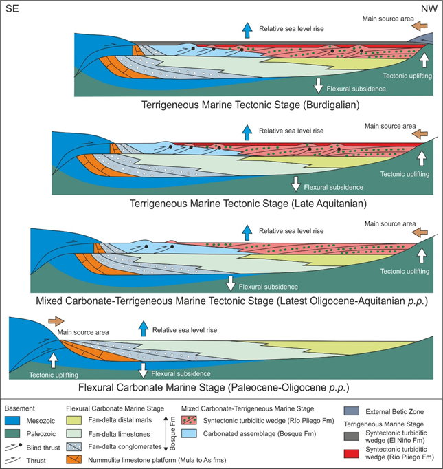
Figure 4. Tectono-sedimentary evolution of the Malaguide Cenozoic basin from Sierra Espuña area (modified from [12][12]).
The flexural carbonate marine stage is coincident with the sedimentary pre-orogenic cycle. In this period the terrigenous sedimentation was very scarce and coming from the southern margin of the basin, while tectonics was restricted to basement folding, stacking of units at a deep level, and propagation of blind thrust not manifested at upper tectonic level (Figure 4).
The following two sedimentary stages coincided with the syn-orogenic evolution of the basin. Mixed carbonate and terrigenous deposition commenced as structures along the basin margins rose above sea-level, particularly in the south, where sediments were sourced from Jurassic to Cenozoic carbonate sediments. During this period, the basin was segmented and compartmentalized by the fold propagation faults, creating a series of local structural highs and subsiding local basins. Finally, the terrigenous deep marine stage clearly shows the paroxysmal tectonics in the area with the main source area from the northern boundary of the basin (basement and Triassic sediments) coincident with a nappe and superficial tectonics.
After this, the Internal Zone was back-thrusted by the External at the Latest Burdigalian, terminating the development of the Cenozoic Malaguide Basin.
References
- Martín-Martín, M.; Guerrera, F.; Tosquella, J.; Tramontana, M. Paleocene-Lower Eocene carbonate platforms of westernmost Tethys. Sediment. Geol. 2020, 404, 105674.
- Perri, F.; Critelli, S.; Martín-Martín, M.; Montone, S.; Amendola, U. Unravelling hinterland and offshore palaeogeography from pre-to-syn-orogenic clastic sequences of the Betic Cordillera (Sierra Espuña), Spain. Palaeogeogr. Palaeoclimatol. Palaeoe-col. 2017, 468, 52–69.
- Martín-Martín, M.; Robles-Marín, M. Alternative methods for calculating compaction in sedimentary basins. Mar. Pet. Geol. 2020, 113, 104132.
- Guerrera, F.; Manuel Martín-Martín, M.; Mario Tramontana, M. Evolutionary geological models of the central-western pe-ri-Mediterranean chains: A review. Int. Geol. Rev. 2021, 63, 65–86.
- Martín-Martín, M.; Rey, J.; Alcalá-García, F.J.; Tosquella, J.; Deramond, J.; Lara-Corona, E.; Duranthon, F.; Antoine, P.O. Tectonic controls of the deposits of a foreland basin: An example from the Eocene Corbières-Minervois basin, France. Basin Res. 2001, 13, 419–433.
- Martín-Martín, M.; Sanz de Galdeano, C.; García-Tortosa, F.J.; Martín-Rojas, I. Tectonic units from the Sierra Espuña-Mula area (SE Spain): Implication on the triassic paleogeography and the geodynamic evolution for the betic-rif internal zone. Geo-din. Acta 2006, 19, 1–9.
- Martín-Martín, M.; Martín-Rojas, I.; Caracuel, J.E.; Estévez-Rubio, A.; Martín-Algarra, A.; Sandoval, J. Tectonic framework and extensional pattern of the Malaguide Complex from Sierra Espuña (Internal Betiz Zone) during Jurassic-Cretaceous: Im-plications for the Westernmost Tethys geodynamic evolution. Int. J. Earth Sci. 2006, 95, 815–826.
- Guerrera, F.; Martín-Martín, M. Geodynamic events reconstructed in the Betic, Maghrebien and Apennine chains (cen-tral-western Tethys). Bull. Société Géologique Fr. 2014, 185, 329–341.
- Jabaloy Sánchez, A.; Martín-Algarra, A.; Padrón-Navarta, J.A.; Martín-Martín, M.; Gómez-Pugnaire, M.T.; López Sánchez-Vizcaíno, V.; Garrido, C.J. Lithological Successions of the Internal Zones and Flysch Trough Units of the Betic Chain. In The Geology of Iberia (A Geodynamic Approach); Springer: Berlin/Heidelberg, Germany, 2019; Chapter 8, pp. 377–432.
- Martín-Martín, M.; Guerrera, F.; Tramontana, M. Geodynamic implications of the latest Chattian-Langhian central-western Mediterranean volcano-sedimentary event: A review. J. Geol. 2020, 128, doi:10.1086/706262.
- Martín-Martín, M.; Guerrera, F.; Miclaus, C.; Tramontana, M. Similar Oligo-Miocene tectono-sedimen-tary evolution of the Paratethyan branches represented by the Moldavidian Basin and Maghrebian Flysch Basin. Sediment. Geol. 2020, 396, 105548.
- Martín-Martín, M.; Martín-Algarra, A. Thrust sequence and syntectonic sedimentation in a piggy-pack basin: The oli-go-aquitanian Mula-Pliego Basin (Internal Betic Zone, SE Spain). Comptes Rendus Geosci. 2002, 334, 363–370.
- Martin-Rojas, I.; Sanz de Galdeano, C.; Martín-Martín, M.; García-Tortosa, F.J. Geometry and kinematics of an antiformal stack deduced from brittle structures. Example of the Internal Betic Zone in the Sierra Espuña (province of urcia, Spain). Comptes Rendus Geosci. 2007, 339, 506–515.
- Lonergan, L. Structural Evolution of the Sierra Espuña, Betic Cordillera, SE Spain. Ph.D. Thesis, University of Oxford, Ox-ford, UK, 1991; 154p.
- Brilha, J. Inventory and Quantitative Assessment of Geosites and Geodiversity Sites: A Review. Geoheritage 2016, 8, 119–134.
- Aulad-Sidi-Mhend, A.; Maaté, A.; Amri, I.; Hlila, R.; Chakiri, S.; Maaté, S.; Martín-Martín, M. The Geological Heritage of the Talassemtane National Park-Ghomara coast Natural Area (NW of Morocco). Geoheritage 2019, 11, 1005–1025.
- Fallot, P. Rapports du Subbétique avec le Bétique dans les Sierras Tercia et Espuña. Comptes Rendus Geosci. 1929, 188, 404.
- Fallot, P. Les Cordillères bétiques. Estud. Geológicos 1948, 8, 83–172.
- Paquet, J. Les unités supérieures de la Sierra de Espuña (Espagne). Bull. Société Géologique Fr. 1962, IV, 857–866.
- Paquet, J. Age auversien de la phase tectonique majeure dans le Bétique de Malaga et le Subbétique de la province de Murcie (Sierras de Espuña et de Ponce). Comptes Rendus Geosci. 1966, 263, 1681–1684.
- Paquet, J. Age de mise en place des unités supérieures de la Sierra de Espuña et de la partie méridionale du Subbétique (prov. de Murcie, Espagne). Bull. Société géologique Fr. 1966, VIII, 946–955.
- Paquet, J. Étude géologique de l'Ouest de la province de Murcie. Bull. Société Géologique Fr. 1969, 111, 270.
- Paquet, J. Transgressivité de l’Eocene supérieur dans les Malaguides de la Sierra Espuña (Cordilléres Bètiques, Sud-Est de l’Espagne). Mise au point. Geol. Mijnb. 1970, 49, 61–64.
- Magné, J.; Paquet, J. Données nouvelles sur l’Éocéne superiéur, l’Oligocè et le Miocène inférieur de la zone séparant le Subbé-tique du Bétique de Málaga au N de la Sierra de Espuña (Cordillères bétiques, Espagne). Bull. Société Géologique Fr. 1967, IX, 225–245.
- Kampschuur, W.; Langeberg, C.W.; Baena, J.; Velando, F.; García-Monzón, G.; Paquet, J.; Rondeel, H.E. Mapa Geológico de España (E. 1:50.000). Hoja de Coy nº 932. Instituto Geológico y Minero de España: Madrid, Spain; 1972.
- Kampschuur, W.; Langenberg, C.W.; Rondeel, H.E.; Espejo, J.A.; Crespo, A.; Pignatelli, R. Mapa Geológico de España (E. 1:50.000). Hoja de Lorca nº 953. Instituto Geológico y Minero de España: Madrid, Spain, 1972.
- Jerez-Mir, L.; Jerez-Mir, F.; García-Monzón, G. Mapa Geológico de España (E. 1:50.000). Hoja de Mula nº 912. I.G.M.E Instituto Geológico y Minero de España: Madrid, Spain, 1972.
- Martín-Martín, M. El Terciario del Dominio Maláguide en Sierra Espuña (Cordillera Bética oriental, SE de España). Ph.D. Thesis, University of Granada, Granada, Spain, 1996; p. 299.
- Martín-Martín, M.; El Mamoune, B.; Martín-Algarra, A.; Martín-Pérez, J.A.; Serra-Kiel, J. Timing of deformation in the Ma-laguide of the Sierra Espuña (Southeastern Spain). Geodynamic evolution f the Internal Betic Zone. Geol. Mijnbow 1997, 75, 309–316.
- Martín-Martín, M.; El Mamoune, B.; Martín-Algarra, A.; Serra-Kiel, J. La formation As, datée de l’Oligocène inferieur, est impliquée dans les charriages des unités malaguides supérieures de la Sierra Espuña (Zones Internes bétiques, prov. de Mur-cie, Espagne). Comptes Rendus Geosci. 1997, 325, 861–868.
- Martín-Martín, M.; Serra-Kiel, J.; El Mamoune, B.; Martín-Algarra, A.; Serrano, F. The Paleocene of the Eastern Malaguides (Betic Cordillera, Spain): Stratigraphy and Paleogeography. Comptes Rendus Geosci. 1998, 326, 35–41.
- Tent-Manclus, J.E.; Martin-Martin, M.; Martin-Perez, J.A.; Serrano, F. Structural evolution of the early Miocene in the eastern Betic internal-external zone boundary (SE Spain). Bull. Société Géologique Fr. 2001, 172, 41–47.
- Manuel Martín Martín, M.; Mancheño, M.A.; Romero, G. La Ruta del Jurásico. Itinerario geológico guiado por el Parque Re-gional de Sierra Espuña. Cons. Agric. Agua Medio Ambiente Región Murcia 2006, 60.
- Martín-Martín, M.; Romero, G.; Mancheño, M.A. Guía Geológica del Parque Regional de Sierra Espuña. Cons. Agric. Agua Medio Ambiente Región Murcia 2010, 221.
- Mancheño Jiménez, M.A.; Rodríguez Estrella, T.; Martín Martín, M.; Romero Sánchez, G. Guía geológica del Parque Regional de la Sierra de la Pila (Murcia). In Una Visión Multidisciplinar del Patrimonio Geológico y Minero. Cuadernos del Museo Geomine-ro; Florido, P., Rábano, I., Eds.; Instituto Geológico y Minero de España: Madrid, Spain, 2010; pp. 425–436.