Your browser does not fully support modern features. Please upgrade for a smoother experience.
Please note this is a comparison between Version 1 by Zhang Zhiqi and Version 2 by Catherine Yang.
Opium poppy is a medicinal plant, and its cultivation is illegal without legal approval in China. Unmanned aerial vehicle (UAV) is an effective tool for monitoring illegal poppy cultivation. Unmanned aerial vehicle (UAV) is more flexible and mobile than remote sensing satellite, and their high-resolution images can help to detect poppies in areas that are hard to see.
- opium poppy detection
- UAV remote sensing
1. Introduction
Poppy is the source of various sedatives and narcotics, such as morphine, codeine, and thebaine. Planting poppies without the permission of relevant authorities is illegal in China. However, poppies, being a plant with medicinal value, are privately grown in some rural areas in China. The illicit cultivation of poppies poses a huge threat to society, and they cause serious harm to people’s physical and mental health [1]. Anti-drug efforts must be controlled at the source of illegal poppy cultivation, which has become a primary task for drug enforcement agencies. Existing opium poppy detection methods rely on field photography and manual collection, which require lots of manpower and material resources. Furthermore, Poppies are often planted in hidden areas in order to avoid inspection by anti-drug department. Traditional object detectors are inefficient and difficult to detect accurately [2][3][2,3]. Moshia et al. [4] conducted an analysis of opium poppy cultivation in Mexico using deep learning techniques. Their study focused solely on distinguishing between corn seedlings and opium poppies.
In recent decades, the rapid development of remote sensing satellites has positioned them as a crucial technology for combating illegal poppy cultivation. Demir et al. [2] have proposed using high-resolution remote sensing satellite images to detect poppy. Their approach has provided a fundamental basis for utilizing remote sensing techniques to detect poppy cultivation in flat regions. Liu et al. [5] collected a remote sensing image dataset of poppies using satellite imagery and employed the SSD model for poppy detection. However, their approach proves ineffective in detecting low-density poppy cultivation in rural areas. There is still illegal poppy cultivation in some rural areas, and it is hard to find by remote sensing satellite because of its scarcity, low density, and interference by other plant species.
Unmanned aerial vehicle (UAV) is more flexible and mobile than remote sensing satellite, and their high-resolution images can help to detect poppies in areas that are hard to see. Zhou et al. [1] employed UAV for monitoring illicit poppy cultivation. Iqbal et al. [6] utilized unmanned systems to estimate the height and yield of cultivated poppy plants. Luo et al. [7] employed a semantic segmentation model for pixel-level extraction of poppy regions and proposed a TransAttention U-Net model. However, poppies at various growth stages bear a striking resemblance to vegetation in terms of shape, rendering existing object detection methods potentially inadequate for accurately identifying poppies.
Preventing illicit poppy cultivation and providing accurate location information to law enforcement personnel still necessitates the design of low-power models suitable for drone platforms. While the aforementioned methods have achieved promising results, existing approaches remain challenging to apply on drone platforms for eradicating illicit poppy cultivation. The pursuit of lightweight and low-power models has been a prominent research focus.
Figure 1 shows some poppy image samples captured by UAV. It can be observed that different growth stages, irregular shapes, low density, and surrounding vegetation interference make it challenging for existing deep learning models to accurately detect poppies.
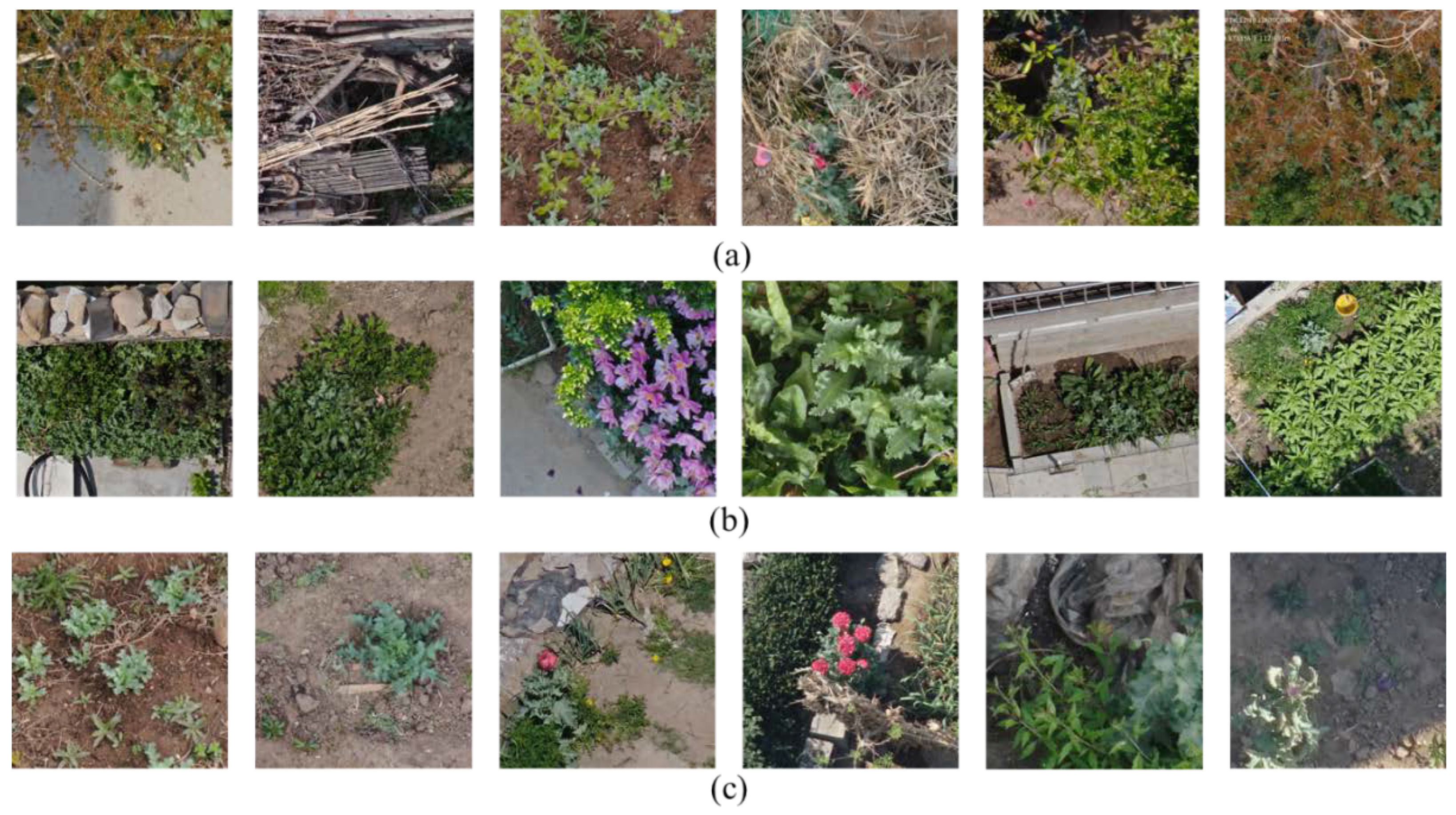
Figure 1.
Samples of opium poppies. (
a
) occlusion, (
b
) confused vegetation, (
c) different growth periods.
) different growth periods.
2. Opium Poppy Detection in Unmanned Aerial Vehicle Imagery
2.1. UAV Remote Sensing
With the development of unmanned aerial vehicle (UAV) remote sensing technology, researchers are using UAV to solve some problems in many fields, e.g., agricultural production, Earth observation, and disaster monitoring [8][9][10][13,14,15]. Feng et al. [11][16] used UAV remote sensing to achieve urban vegetation mapping. Ye et al. [12][17] proposed a UAV-based remote sensing image processing method for the recognition of banana fusarium, their method provided guidance for banana cultivation. Alvarez-Vanhard et al. [13][18] argued that the combination of UAV and remote sensing satellite is potentially valuable for Earth observation. Maes and Steppe [14][19] gave a detailed analysis of the application of UAV remote sensing technology in precision agricultural production. In the field of plant disease detection, Wang et al. [15][20] proposed an automatic classification method for cotton root rot disease based on UAV remote sensing images. Pu et al. [16][21] proposed a UAV platform flow-susceptibility detection and counting model based on YOLO. Their method was successfully applied in practical detection scenarios. The above cases show that UAV remote sensing technology has been widely used in many fields and has achieved excellent effects, especially in the monitoring of plant diseases in precision agriculture. In recent years, with the development of deep learning technology, many object detection algorithms have been used in various fields [17][18][19][20][21][22][23][24][25][26][22,23,24,25,26,27,28,29,30,31], including smart agriculture, industrial production, medical image processing, remote sensing image processing, and more. With the rapid development of drones in various fields, communication security has gradually become an important research area in drone transmission [27][32], especially in crucial sectors such as military applications [28][33].
YOLO family [29][30][31][32][33][8,9,10,11,12] is one of the most popular object detection methods. Many scholars improve the detection ability of the YOLO model by designing excellent feature extraction modules and inserting attention mechanisms to meet the needs of different task scenarios. However, it is still necessary to design a professional object detection model for UAV poppy detection.
2.2. Opium Poppy Detection Based on CNN
Some scholars have conducted research related to opium poppy detection. For example, Wang et al. [34] proposed an improved YOLOV3 model to achieve rapid and accurate image processing in low-altitude remote sensing poppy inspection. Zhou et al. [3] proposed an SPP-GIoU-YOLOv3-MN model-based YOLOV3, Spatial Pyramid Pooling (SPP) unit, and Generalized Intersection over Union (GIoU) for UAV opium poppy detection and achieved a better performance than general YOLOv3. Wang et al. [35] proposed an opium poppy image detection system based on YOLOV5s and DenseNet121, which reduced the number of incorrectly detected images by 73.88% and greatly reduced the workload of subsequent manual screening of remote sensing images. Rominger et al. [36] suggested using UAV imagery to study endangered plant species such as opium poppy. They used images with a resolution of 50 m to find marked poppy plants and then used 15 m images to locate them accurately. He et al. [37] proposed to use hyperspectral imaging and spectral matching classification techniques to identify poppies and distinguish them from the surrounding environments. Pérez-Porras et al. [38] proposed an early opium poppy detection method and used YOLOV3, V4, and V5 frameworks as basic models to perform extensive comparative experiments. They concluded that the YOLOV5s model has higher performance in speed and accuracy.