Your browser does not fully support modern features. Please upgrade for a smoother experience.
Please note this is a comparison between Version 2 by Camila Xu and Version 1 by Md Muzakkir Quamar.
Drones, also known as unmanned aerial vehicles (UAVs), have gained numerous applications due to their low cost, ease of use, vertical takeover and landing, and ability to operate in high-risk or hard-to-reach areas. Geographic Information System (GIS) refers to a field of science that involves the study of the lands, features, inhabitants, and phenomena of the Earth. GIS is a comprehensive framework that includes the processes of acquiring, retaining, modifying, examining, and presenting geographical data in an effective and streamlined way.
- drone
- GIS
- mapping
- aerial photogrammetry
- GPS
- smart city
1. Introduction
Geographic Information System (GIS) refers to a field of science that involves the study of the lands, features, inhabitants, and phenomena of the Earth. GIS is a comprehensive framework that includes the processes of acquiring, retaining, modifying, examining, and presenting geographical data in an effective and streamlined way [1]. The software package under consideration may be described as a tool that effectively establishes a connection between graphical information and attribute data recorded in a database, and vice versa [2,3][2][3]. GIS provides a range of tools that may enhance operational efficiency and effectiveness in handling both spatial and non-spatial characteristic data [4,5][4][5].
The integration of drones with advanced technologies such as artificial intelligence (AI), machine learning (ML), cutting-edge equipment including high-definition (HD) cameras, precision lenses, light detection and ranging (LiDAR), and the computational efficiency afforded by cloud storage and computing has witnessed exponential growth across diverse domains. Accordingly, GIS has revolutionized the field of data collection and analysis. Drones help to procure high-resolution images and collect a plethora of data. GIS, on the other hand, is a technology that captures, manages, analyzes, and displays spatial or geographic data [6]. A simple pictorial representation highlighting the different functions of drones and GIS as well as their potential integrated applications is shown in Figure 1. The integration of these two technologies has brought numerous benefits, especially in areas such as mapping, surveying [7], disaster management [8], and agriculture [9].
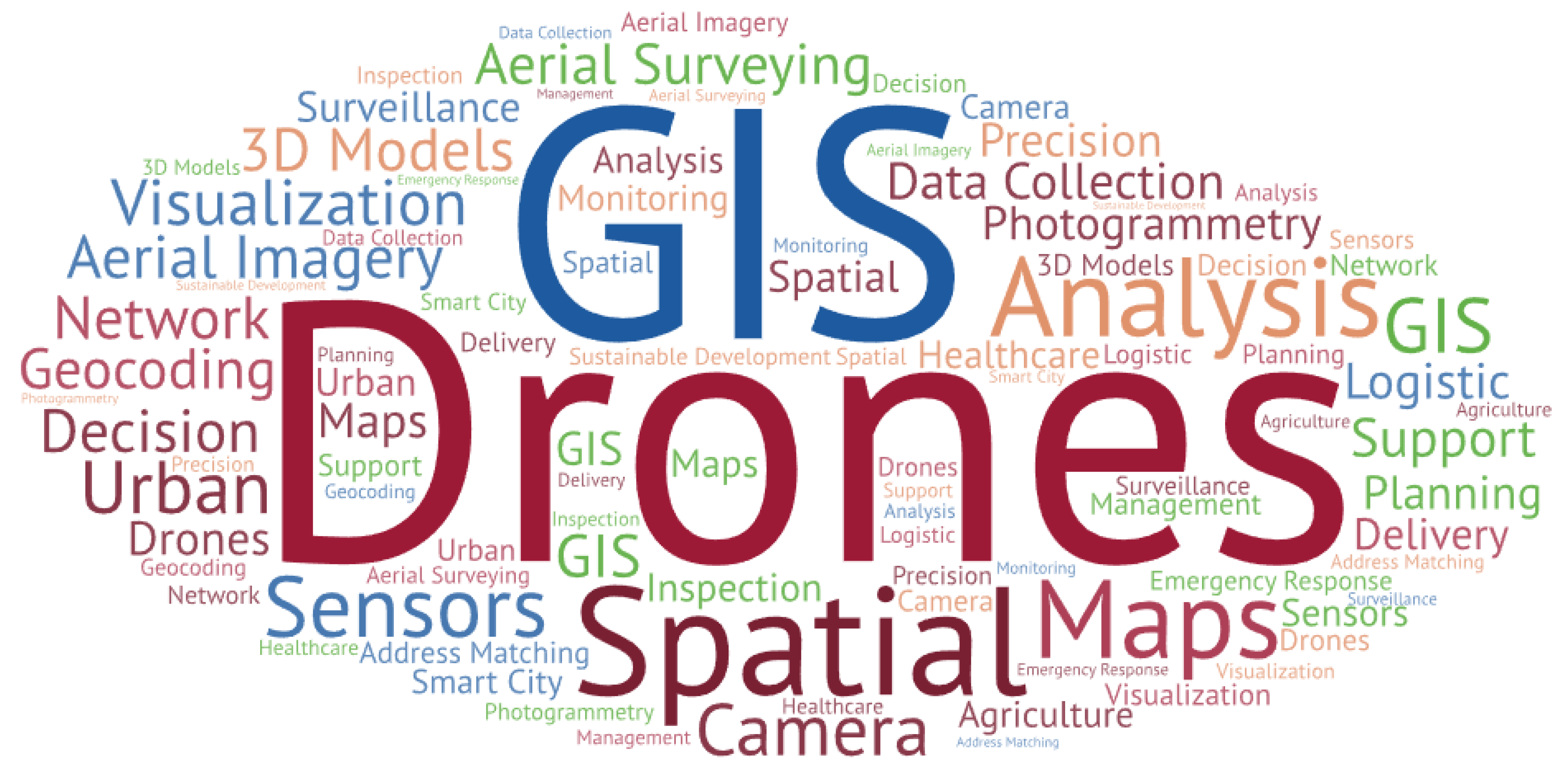
Figure 1.
The potential functions and applications of GIS-integrated drone technology.
1.1. Incorporation of GIS–Drone Technology
Drones equipped with high-resolution cameras can capture detailed images of the terrain and produce accurate maps of an area. These maps can be used in urban planning, land-use management, and environmental monitoring [10]. Surveyors can also use drones to capture topographic data and produce digital elevation models (DEMs) that are useful in various fields such as civil engineering and mining [11,12][11][12]. Another important application of GIS-integrated drone technology is disaster management and emergency response assistance [8]. Drones equipped with thermal cameras can be used to detect and monitor wildfires and other natural disasters [13]. Drones can also be used to assess the damage caused by disasters and identify areas that need immediate attention [14]. GIS can be used to analyze the data collected by drones and produce maps that show the extent of the damage and the areas that need assistance.
1.2. Use Cases and Applicative Scope
In agriculture, drones integrated with GIS can be used to monitor crop growth and health [15]. Drones can capture multispectral images of crops, which can be used to detect the early signs of disease or stress. GIS can then be used to analyze data and produce maps that show the areas that need attention. This can help farmers take timely action and improve their yields [16,17][16][17]. Apart from these applications, drone-integrated GIS can also be used in wildlife monitoring, infrastructure inspection, and search and rescue operations. In wildlife monitoring, drones can be used to capture images of animals and track their movement [18,19][18][19]. In infrastructure inspection, drones can be used to inspect bridges, power lines, and other structures that are difficult to access [20,21][20][21]. In search and rescue operations, drones can be used to search for missing persons or to locate stranded individuals [22,23][22][23].
Furthermore, drones integrated with GIS can play a crucial role in smart city management and sustainable development [24,25][24][25]. GIS is a technology that captures, manages, analyzes, and presents geographical data in a way that helps decision-makers make informed choices. By integrating drones with GIS, city managers can collect and analyze data on various aspects of the city such as traffic management [26], public safety [27], and environmental monitoring [28]. Drones integrated with GIS have the ability to map and monitor changes in urban landscapes [29]. By capturing aerial imagery and analyzing it using GIS, city planners can track changes in land use, detect illegal construction, and identify areas in need of development. This information can be used to develop more sustainable urban planning strategies that promote environmentally friendly and socially equitable growth [30]. A generalized flowchart for the implementation of GIS–drone technology is depicted in Figure 2 [31].
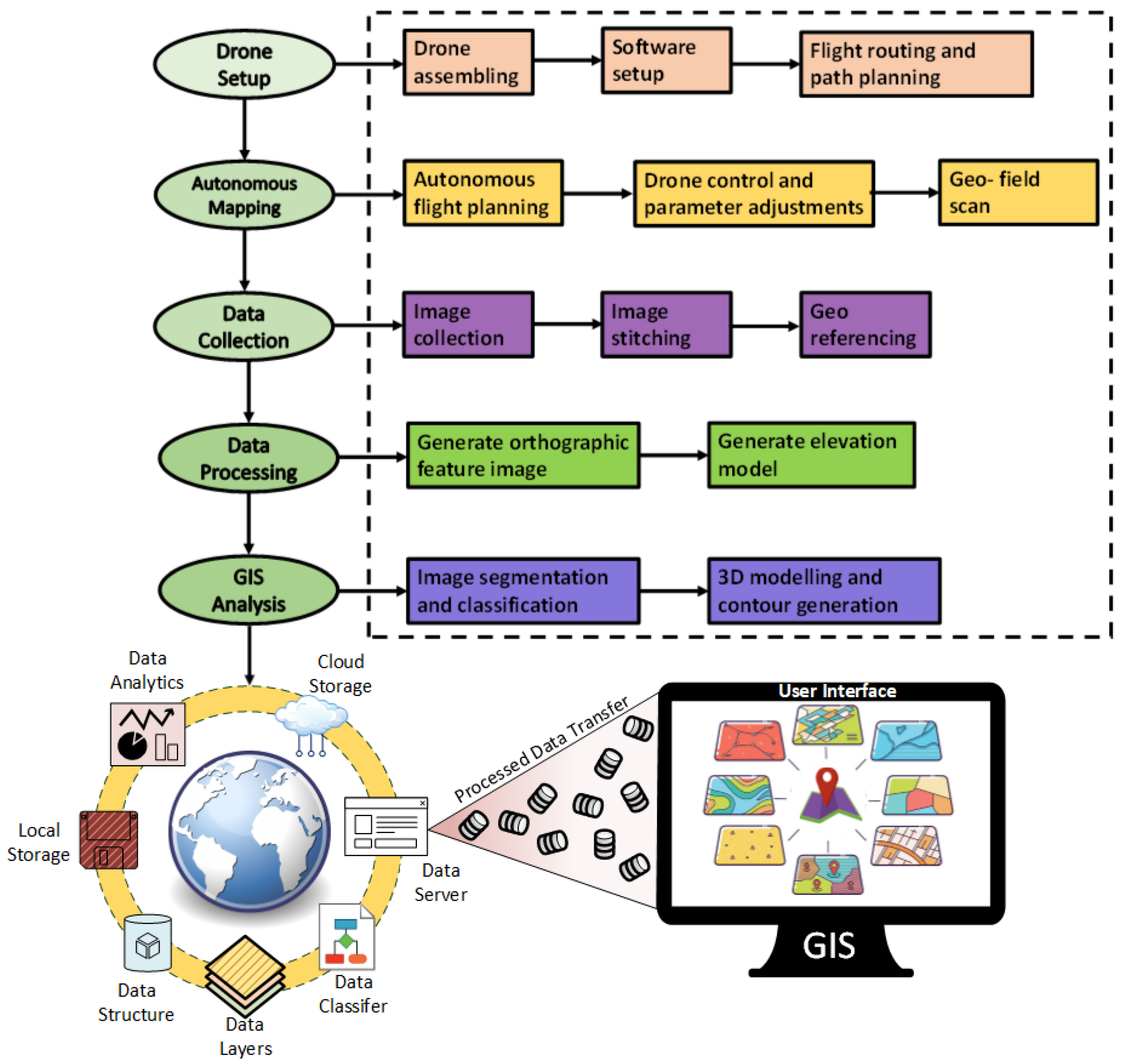
Figure 2.
Process and formulation of GIS using drones.
2. Background
As a powerful tool, GIS technology has a wide range of applications in various fields, including urban planning, environmental management, health, agriculture, transportation, and emergency response. Although GIS was traditionally used for spatial data analysis and visualization for several decades, with evolving technologies, GIS has also evolved and has significantly contributed to different fields and applications. For example, the integration of remote sensing technology with GIS in the 1980s and 1990s was a significant milestone in the evolution of GIS technology. Remote sensing technology uses satellite imagery to collect data on the Earth’s surface. These data are then integrated into GIS systems to create detailed maps of the environment. This integration allowed for the creation of more accurate and comprehensive maps, which were used for a wide range of applications, including environmental monitoring, land-use planning, and natural resource management [6,30][6][30].
Another breakthrough integration was that of global positioning systems (GPSs) and GIS. GPS technology uses satellite signals to determine the location of objects on the Earth’s surface. The integration of GPS technology with GIS allowed for the creation of real-time maps that could track the movement of objects, including vehicles, people, and animals. The GIS and GPS integration revolutionized the transport and logistics industry [37][32]. One of the earliest applications of GIS and GPS integration was in the field of wildlife tracking [38][33]. Researchers used GPS technology to track the movement of animals and GIS technology to analyze the spatial data collected. This helped to understand the behavior and movement patterns of animals and inform wildlife conservation efforts [39,40][34][35]. The recent development in GIS technology integrated with mobile devices such as smartphones and tablets has further revolutionized GIS applications. Computing devices allow to collect spatial data in the field and transmit these to a central database for analysis. For example, in the field of emergency response, mobile devices equipped with GIS technology allow emergency responders to collect real-time data on the location and extent of emergencies, which is then transmitted to a central database for analysis. This helps inform emergency response efforts and improve response times [41][36].
An interesting cross-pollination of GIS is drone technology. The technology of drones has evolved over time with numerous upgrades, installations, and optimizations increasing its potential as well as application in numerous different studies [42,43,44,45][37][38][39][40]. Drones or unmanned aerial vehicles (UAVs) have revolutionized the field of GIS by providing high-resolution, accurate, and up-to-date imagery data that can be used for a variety of GIS applications [46][41]. Initially, drones were used for aerial photography and videography, but with the introduction of specialized sensors such as LiDAR and hyperspectral cameras, drones can now collect data on vegetation health, topography, and water quality [47][42]. These sensors can provide highly accurate and detailed data that can be used for a variety of GIS applications, including precision agriculture, land-use planning, and natural resource management. The integration of drone technology with GIS has also become more streamlined, with the development of software and platforms that can process and analyze drone-collected data. This has made it easier for GIS professionals to incorporate drone data into their existing GIS workflows and analysis [12,48][12][43].
The use of drones in GIS applications is on the rise and is a popular topic for future research. The global GIS–drone mapping market is expected to reach a valuation of USD 349.5 million in 2023 and is projected to grow at a compound annual growth rate of 16.5 %, reaching up to USD 1609.6 million in the next ten years [49][44].
References
- Kennedy, M.D. Introducing Geographic Information Systems with ARCGIS: A Workbook Approach to Learning GIS; John Wiley & Sons: Hoboken, NJ, USA, 2013.
- Lü, G.; Batty, M.; Strobl, J.; Lin, H.; Zhu, A.; Chen, M. Reflections and speculations on the progress in geographic information systems (GIS): A geographic perspective. Int. J. Geogr. Inf. Sci. 2019, 33, 346–367.
- West, H.; Horswell, M. GIS has changed! Exploring the potential of ArcGIS online. Teach. Geogr. 2018, 43, 22–24.
- Budiharto, W.; Irwansyah, E.; Suroso, J.S.; Chowanda, A.; Ngarianto, H.; Gunawan, A.A.S. Mapping and 3D modelling using quadrotor drone and GIS software. J. Big Data 2021, 8, 1–12.
- Scott, L.M.; Janikas, M.V. Spatial statistics in ArcGIS. In Handbook of Applied Spatial Analysis: Software Tools, Methods and Applications; Springer: Berlin/Heidelberg, Germany, 2009; pp. 27–41.
- Panigrahi, N.; Panigrahi, S. Processing data acquired by a drone using a GIS: Designing a size-, weight-, and power-constrained system. IEEE Consum. Electron. Mag. 2018, 7, 50–54.
- Jiang, Y.; Huang, Y.; Liu, J.; Li, D.; Li, S.; Nie, W.; Chung, I.H. Automatic volume calculation and mapping of construction and demolition debris using drones, deep learning, and GIS. Drones 2022, 6, 279.
- Tonti, I.; Lingua, A.M.; Piccinini, F.; Pierdicca, R.; Malinverni, E.S. Digitalization and spatial documentation of post-earthquake temporary housing in Central Italy: An integrated geomatic approach involving UAV and a GIS-based system. Drones 2023, 7, 438.
- Fareed, N.; Rehman, K. Integration of remote sensing and GIS to extract plantation rows from a drone-based image point cloud digital surface model. ISPRS Int. J. -Geo-Inf. 2020, 9, 151.
- Yu, J.; Zeng, P.; Yu, Y.; Yu, H.; Huang, L.; Zhou, D. A combined convolutional neural network for urban land-use classification with GIS data. Remote. Sens. 2022, 14, 1128.
- Pérez-Álvarez, R.; Sedano-Cibrián, J.; de Luis-Ruiz, J.M.; Fernández-Maroto, G.; Pereda-García, R. Mining exploration with UAV, low-cost thermal cameras and GIS tools—Application to the specific case of the complex sulfides hosted in carbonates of Udías (Cantabria, Spain). Minerals 2022, 12, 140.
- Zhang, F.; Cao, N. Application and research progress of geographic information system (GIS) in agriculture. In Proceedings of the 2019 8th International Conference on Agro-Geoinformatics, Agro-Geoinformatics 2019, Istanbul, Turkey, 16–19 July 2019.
- Penglase, K.; Lewis, T.; Srivastava, S.K. A new approach to estimate fuel budget and wildfire hazard assessment in commercial plantations using drone-based photogrammetry and image analysis. Remote Sens. 2023, 15, 2621.
- Bilașco, t.; Hognogi, G.G.; Roșca, S.; Pop, A.M.; Iuliu, V.; Fodorean, I.; Marian-Potra, A.C.; Sestras, P. Flash flood risk assessment and mitigation in digital-era governance using unmanned aerial vehicle and GIS spatial analyses case study: Small river basins. Remote Sens. 2022, 14, 2481.
- Plata, I.T.; Panganiban, E.B.; Alado, D.B.; Taracatac, A.C.; Bartolome, B.B.; Labuanan, F.R.E. Drone-based geographical information system (GIS) mapping of cassava pythoplasma disease (CPD) for precision agriculture. Int. J. Emerg. Technol. Adv. Eng. 2022, 12, 1–9.
- Prajapati, J.B.; Barad, R.; Patel, M.B.; Saini, K.; Prajapati, D.; Engineer, P. Smart farming ingredients: IoT sensors, software, connectivity, data analytics, robots, drones, GIS-GPS. In Applying Drone Technologies and Robotics for Agricultural Sustainability; IGI Global: Hershey, PA, USA, 2023; pp. 31–49.
- Cui, J.; Zheng, H.; Zeng, Z.; Yang, Y.; Ma, R.; Tian, Y.; Tan, J.; Feng, X.; Qi, L. Real-time missing seedling counting in paddy fields based on lightweight network and tracking-by-detection algorithm. Comput. Electron. Agric. 2023, 212, 108045.
- Colpaert, A. Satellite and UAV Platforms, Remote Sensing for Geographic Information Systems; Multidisciplinary Digital Publishing Institute: Basel, Switzerland, 2022.
- Jessin, J.; Heinzlef, C.; Long, N.; Serre, D. A systematic review of UAVs for island coastal environment and risk monitoring: Towards a Resilience Assessment. Drones 2023, 7, 206.
- Rangel, R.K.; Maitelli, A.L.; Rodrigues, V.A.; Valente, D.R.G. Smart cities-automatic power lines inspection. In Proceedings of the 2022 IEEE Aerospace Conference (AERO), Big Sky, MT, USA, 5–12 March 2022; pp. 1–14.
- Cano-Solis, M.; Ballesteros, J.R.; Branch-Bedoya, J.W. VEPL Dataset: A vegetation encroachment in power line corridors dataset for semantic segmentation of drone aerial orthomosaics. Data 2023, 8, 128.
- Barone, P.M.; Di Maggio, R.M.; Mesturini, S. A complementary remote-sensing method to find persons missing in water: Two case studies. Forensic Sci. 2023, 3, 284–292.
- Lyu, M.; Zhao, Y.; Huang, C.; Huang, H. Unmanned aerial vehicles for search and rescue: A survey. Remote. Sens. 2023, 15, 3266.
- Prabu, B.; Malathy, R.; Taj, M.G.; Madhan, N. Drone Networks and Monitoring Systems in Smart Cities; CRC Press: Boca Raton, FL, USA, 2023.
- Nguyen, D.D.; Alharasees, O.; Kale, U.; Ugur, M.; Karakoc, T.H. “Drones GIS System” in Urban Transport. In Proceedings of the International Symposium on Energy Management and Sustainability; Springer: Berlin/Heidelberg, Germany, 2022; pp. 733–741.
- Ranganathan, R.H.; Balusamy, S.; Partheeban, P.; Mani, C.; Sridhar, M.; Rajasekaran, V. Air quality monitoring and analysis for sustainable development of solid waste dump yards using smart drones and geospatial technology. Sustainability 2023, 15, 13347.
- He, R.; Xu, Y.; Jiang, S. Applications of GIS in public security agencies in China. Asian J. Criminol. 2022, 17, 213–235.
- Kim, M.S.; Hong, W.H.; Lee, Y.H.; Baek, S.C. Selection of take-off and landing sites for firefighter drones in urban areas using a GIS-based multi-criteria model. Drones 2022, 6, 412.
- Cohen, M.C.L.; de Souza, A.V.; Liu, K.b.; Yao, Q. A timely method for post-disaster assessment and coastal landscape survey using drone and satellite imagery. MethodsX 2023, 10, 102065.
- Hognogi, G.; Pop, A.; Marian-Potra, A.; Someșfălean, T. The role of UAS–GIS in digital era governance. A systematic literature review. Sustainability 2021, 13, 11097.
- Yang, B.; Hawthorne, T.L.; Hessing-Lewis, M.; Duffy, E.J.; Reshitnyk, L.Y.; Feinman, M.; Searson, H. Developing an introductory UAV/drone mapping training program for seagrass monitoring and research. Drones 2020, 4, 70.
- Sibanda, M.; Mutanga, O.; Chimonyo, V.G.P.; Clulow, A.D.; Shoko, C.; Mazvimavi, D.; Dube, T.; Mabhaudhi, T. Application of drone technologies in surface water resources monitoring and assessment: A systematic review of progress, challenges, and opportunities in the global south. Drones 2021, 5, 84, Erratum in Drones 2022, 65, 131.
- Fudala, K.; Bialik, R.J. Identifying important bird and biodiversity areas in Antarctica using RPAS surveys—A case study of Cape Melville, King George Island, Antarctica. Drones 2023, 7, 538.
- Dinko, D.H.; Nyantakyi-Frimpong, H. The prospects and challenges of using drone-based participatory mapping in human-environment research. Prof. Geogr. 2022, 75, 1–11.
- Bassi, E. European drones regulation: Today’s legal challenges. In Proceedings of the International Conference on Unmanned Aircraft Systems, ICUAS, Atlanta, GA, USA, 11–14 June 2019; pp. 443–450.
- Radoglou–Grammatikis, P.; Sarigiannidis, P.; Lagkas, T.; Moscholios, I. A compilation of UAV applications for precision agriculture. Comput. Netw. 2020, 172, 107148.
- Quamar, M.M.; El Ferik, S. Cooperative prey hunting for multi agent system designed using bio-inspired adaptation technique. In Proceedings of the 2023 International Conference on Control, Automation and Diagnosis (ICCAD), Rome, Italy, 10–12 May 2023; pp. 1–6.
- Matani, A.G. Internet of things and internet of drones in the renewable energy infrastructure towards energy optimization. In AI and IOT in Renewable Energy; Springer: Singapore, 2021; pp. 15–26.
- Munawar, H.S.; Hammad, A.W.; Waller, S.T. Disaster region coverage using drones: Maximum area coverage and minimum resource utilisation. Drones 2022, 6, 96.
- Quamar, M.M.; ElFerik, S. Control and coordination for swarm of UAVs under multi-predator attack. In Proceedings of the 2023 Systems and Information Engineering Design Symposium (SIEDS), Virtual Conference, 29–30 April 2021; pp. 96–101.
- Bikbulatova, G.; Kupreyeva, E.; Pronina, L.; Shayakhmetov, M. Using remote sensing methods in precision agriculture. In Proceedings of the International Scientific Conference The Fifth Technological Order: Prospects for the Development and Modernization of the Russian Agro-Industrial Sector (TFTS 2019); Atlantis Press: Amsterdam, The Netherlands, 2020; pp. 55–59.
- Peterson, E.A.; Carne, L.; Balderamos, J.; Faux, V.; Gleason, A.; Schill, S.R. The use of unoccupied aerial systems (UASs) for quantifying shallow coral reef restoration success in Belize. Drones 2023, 7, 221.
- Maulana, H.; Kanai, H. Development of precision agriculture models for medium and small-scale agriculture in Indonesia. Proc. Iop Conf. Ser. Mater. Sci. Eng. 2020, 879, 012085.
- Drone Gis Mapping Market Share & Growth Statistics. 2023. Available online: https://www.factmr.com/report/drone-gis-mapping-market (accessed on 7 May 2023).
More