Disaster management is a critical area that requires efficient methods and techniques to address various challenges. An increasing number of studies have elaborated on the importance and applications of remote sensing in disaster management. A major reason for the adoption of remote sensing is that it is one of the fastest means of acquiring data for pre-disaster and post-disaster studies. It is used to provide data for damage assessment in a timely manner and to assist in evaluation and rehabilitation plans. During the pre-disaster phase, remote sensing can be applied to identify and develop adequate systems and resources before the occurrence of a disaster. Adequate systems and resources can ensure that the response to a disaster is coordinated and efficient and that the recovery time is minimal.
- disaster management
- natural disasters
- floods
- wildfire
- earthquake
- ecosystem
1. Introduction
2. Earthquake
2.1. Analysis of Earthquake Keywords
Figure 31 shows that there are five common ways to discuss earthquakes: vibration, seismology, tremor, seismic, and soil mechanism.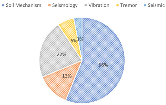
2.2. Analysis of Detector Keywords
2.3. Findings on Different Earthquake Detectors
2.4. Analysis of Earthquake Effects on the Environment
3. Floods
3.1. Data Analytics and Machine Learning for Floods
3.2. Geographical Information System and Spatial Data Management
3.3. Model-Driven Engineering
3.4. Sensors Network and Internet of Things
3.5. Big Data Analysis and Cloud Computing
3.6. Google Earth Engine
4. Applications Based on Remote Sensing for Disasters
4.1. Wildfires
Wildfires, like other disasters, pose threats to life and property; moreover, they contribute to carbon emissions. Remote sensing data can prove valuable in fire detection, monitoring, modeling, and burnt area mapping. Satellite sensors with high temporal resolution, such as GOES (Geostationary Operational Environmental Satellite) and SEVIRI (approximately 30 min), have been utilized for fire monitoring [55]. Sensors with thermal and infrared capabilities, such as MODIS and AVHRR, can be employed as well. Burnt area mapping is accomplished through a multi-temporal comparison of NDVI using visible and near-infrared sensors [55,56].4.2. Earthquakes
Earthquakes are natural disasters associated with earth movements, while landslides result from mass movements. Predicting earthquakes and volcanic eruptions remains challenging, limiting earthquake disaster management to preparedness and relief. Remote sensing has proven highly valuable across all phases of volcanic eruption disaster management, while its usefulness for earthquakes and landslides is somewhat limited [58]. Tralli et al. [59] suggested that high-resolution digital elevation models (DEMs) such as InSAR and LIDAR combined with in situ data and imaging spectroscopy, e.g., ASTER, MODIS, and Hyperion, can aid in assessing and monitoring volcanic and landslide hazards. Sensors such as ASTER can be utilized to monitor earthquake-induced landslide dams for hazard mitigation in case of dam breach [60]. Satellite remote sensing imagery was successfully employed for deployment, data collection, and dissemination during disaster management operations following the Haiti earthquake [61].4.3. Floods
4.2. Earthquakes
Earthquakes are natural disasters associated with earth movements, while landslides result from mass movements. Predicting earthquakes and volcanic eruptions remains challenging, limiting earthquake disaster management to preparedness and relief. Remote sensing has proven highly valuable across all phases of volcanic eruption disaster management, while its usefulness for earthquakes and landslides is somewhat limited [26]. Tralli et al. [27] suggested that high-resolution digital elevation models (DEMs) such as InSAR and LIDAR combined with in situ data and imaging spectroscopy, e.g., ASTER, MODIS, and Hyperion, can aid in assessing and monitoring volcanic and landslide hazards. Sensors such as ASTER can be utilized to monitor earthquake-induced landslide dams for hazard mitigation in case of dam breach [28]. Satellite remote sensing imagery was successfully employed for deployment, data collection, and dissemination during disaster management operations following the Haiti earthquake [29].4.3. Floods
4.4. Impacts of Disaster Management System on Human Beings
-
Loss of Life and Injury: Technical problems in crisis management systems can slow down response and rescue efforts. This may cause delays in reaching affected areas, resulting in a larger number of casualties and injuries.
-
Psychological Distress: When emergency management systems do not work well, people may feel alone and overwhelmed. This can make them feel more stressed, anxious, and traumatized.
-
Disruption of Social Networks: When a disaster strikes, people often band together to help each other. Technical problems with crisis management systems can make it hard for people and communities to talk to each other and coordinate their relief efforts.
-
Loss of Culture: Sometimes, disasters can damage or destroy culturally important locations and artifacts. Technical problems could make it harder to maintain and protect these important parts of cultural identity.
-
Economic Loss: Technical flaws can stymie disaster response and recovery efforts, resulting in protracted downtime for businesses and key infrastructure. People, companies, and governments may lose money because of such disruptions.
-
Inequality and Vulnerability: Vulnerable individuals, such as the elderly, disabled, or disadvantaged communities, may experience additional difficulties obtaining resources during catastrophes. Technical problems can make these differences worse, placing groups even more at risk.
-
Migration and Displacement: If emergency management systems do not provide people with the right information or help, they may have to move or be moved in order to obtain help and resources.
-
Lack of Information: During disasters, timely and accurate information is critical. Technical problems with communication systems can cause people to receive the wrong information, resulting in confusion and fear.
-
Interconnected Disasters: In complex disasters with multiple events, technical problems can make it hard to obtain a full picture of events, in turn making it difficult to coordinate reactions.
-
Loss of Trust in Institutions: Persistent technological failures in disaster management systems can erode public trust in government agencies and other institutions responsible for disaster response and management.
-
Long-Term Recovery Challenges: It might be difficult to plan for effective recovery and mitigation plans when technical issues that hamper data collection and analysis make it impossible to estimate the long-term effects of catastrophes.
References
- Okada, T.; Larcombe, P.; Mason, C. Estimating the spatial distribution of dredged material disposed of at sea using particle-size distributions and metal concentrations. Mar. Pollut. Bull. 2009, 58, 1164–1177.
- Othman, S.H.; Beydoun, G. A metamodel-based knowledge sharing system for disaster management. Expert Syst. Appl. 2016, 63, 49–65.
- Recker, J. “Modeling with tools is easier, believe me”—The effects of tool functionality on modeling grammar usage beliefs. Inf. Syst. 2012, 37, 213–226.
- Yahya, H.; Latif, A.A.; Ahmad, M.N. A preliminary study of the construction of ontology-based flood management systems. In Proceedings of the 2017 6th ICT International Student Project Conference (ICT-ISPC), Johor, Malaysia, 23–24 May 2017; pp. 1–4.
- Greenfield, J.; Short, K. Software factories: Assembling applications with patterns, models, frameworks and tools. In Proceedings of the Companion of the 18th annual ACM SIGPLAN Conference on Object-Oriented Programming, Systems, Languages, and Applications, Anaheim, CA, USA, 26–30 October 2003; pp. 16–27.
- Sulasikin, A.; Nugrahat, Y.; Aminanto, M.E.; Nasution, B.I.; Kanggrawan, J.I. Developing a knowledge management system for supporting flood decision-making. In Proceedings of the 2022 IEEE International Smart Cities Conference (ISC2), Pafos, Cyprus, 26–29 September 2022; pp. 1–4.
- Aini, M.; Fakhru’l-Razi, A.; Daud, M.; Adam, N.; Abdul Kadir, R. Analysis of royal inquiry report on the collapse of a building in Kuala Lumpur: Implications for developing countries. Disaster Prev. Manag. Int. J. 2005, 14, 55–79.
- Flannigan, M.D.; Amiro, B.D.; Logan, K.A.; Stocks, B.J.; Wotton, B.M. Forest fires and climate change in the 21st century. Mitig. Adapt. Strateg. Glob. Chang. 2006, 11, 847–859.
- Bowman, D.M.; Balch, J.; Artaxo, P.; Bond, W.J.; Cochrane, M.A.; D’antonio, C.M.; DeFries, R.; Johnston, F.H.; Keeley, J.E.; Krawchuk, M.A.; et al. The human dimension of fire regimes on Earth. J. Biogeogr. 2011, 38, 2223–2236.
- Filkov, A.I.; Ngo, T.; Matthews, S.; Telfer, S.; Penman, T.D. Impact of Australia’s catastrophic 2019/20 bushfire season on communities and environment. Retrospective analysis and current trends. J. Saf. Sci. Resil. 2020, 1, 44–56.
- Richards, L.; Brew, N.; Smith, L. 20 Australian bushfires—Frequently asked questions: A quick guide. Res. Pap. Ser. 2019, 2020.
- British Broadcasting Company. Australian Fires: Why Do People Start Fires during Fires? 2019. Available online: https://www.bbc.com/news/world-australia-50400851 (accessed on 14 September 2022).
- Williams, A.P.; Abatzoglou, J.T.; Gershunov, A.; Guzman-Morales, J.; Bishop, D.A.; Balch, J.K.; Lettenmaier, D.P. Observed impacts of anthropogenic climate change on wildfire in California. Earth’s Future 2019, 7, 892–910.
- Ribeiro, L.M.; Viegas, D.X.; Almeida, M.; McGee, T.K.; Pereira, M.G.; Parente, J.; Xanthopoulos, G.; Leone, V.; Delogu, G.M.; Hardin, H. Extreme wildfires and disasters around the world: Lessons to be learned. In Extreme Wildfire Events and Disasters; Elsevier: Amsterdam, The Netherlands, 2020; pp. 31–51.
- Naeher, L.P.; Brauer, M.; Lipsett, M.; Zelikoff, J.T.; Simpson, C.D.; Koenig, J.Q.; Smith, K.R. Woodsmoke health effects: A review. Inhal. Toxicol. 2007, 19, 67–106.
- Walter, C.M.; Schneider-Futschik, E.K.; Knibbs, L.D.; Irving, L.B. Health impacts of bushfire smoke exposure in Australia. Respirology 2020, 25, 495–501.
- Becker, J.S.; Paton, D.; Johnston, D.M.; Ronan, K.R. A model of household preparedness for earthquakes: How individuals make meaning of earthquake information and how this influences preparedness. Nat. Hazards 2012, 64, 107–137.
- Dutta, P.K. Earthquake alarm detector microcontroller based circuit for issuing warning for vibration in steel foundations. Int. J. Mechatron. Electr. Comput. Technol. 2017, 7, 3582–3594.
- Pelliccia, R.A. Vibration Sensor and Electrical Power Shut off Device. U.S. Patent 4,390,922, 28 June 1983.
- Tomaneng, S.D.G.; Docdoc, J.A.P.; Hierl, S.A.; Cerna, P.D. Towards the Development a Cost-effective Earthquake Monitoring System and Vibration Detector with SMS Notification Using IOT. Int. J. Eng. Manuf. 2022, 12, 22.
- Cakir, T. Evaluation of the effect of earthquake frequency content on seismic behavior of cantilever retaining wall including soil–structure interaction. Soil Dyn. Earthq. Eng. 2013, 45, 96–111.
- Liu, X.; Li, Y. Experimental study of seismic behavior of partially corrosion-damaged reinforced concrete columns strengthened with FRP composites with large deformability. Constr. Build. Mater. 2018, 191, 1071–1081.
- Aczel, M.; Makuch, K. Shale, quakes, and high stakes: Regulating fracking-induced deismicity in Oklahoma, USA and Lancashire, UK. Case Stud. Environ. 2019, 3, 1–14.
- Leblon, B.; Bourgeau-Chavez, L.; San-Miguel-Ayanz, J. Use of remote sensing in wildfire management. In Sustainable Development-Authoritative and Leading Edge Content for Environmental Management; Books on Demand: Norderstedt, Germany, 2012; pp. 55–82.
- Chuvieco, E.; Congalton, R.G. Application of remote sensing and geographic information systems to forest fire hazard mapping. Remote Sens. Environ. 1989, 29, 147–159.
- Van Westen, K.; Soeters, R.; Buchroithner, M.F. Potential and limitations of satellite remote sensing for geo-disaster reduction. Int. Arch. Photogramm. Remote Sens. 1996, 6, 39–44.
- Tralli, D.M.; Blom, R.G.; Zlotnicki, V.; Donnellan, A.; Evans, D.L. Satellite remote sensing of earthquake, volcano, flood, landslide and coastal inundation hazards. ISPRS J. Photogramm. Remote Sens. 2005, 59, 185–198.
- Parvaiz, I.; Champatiray, P.; Bhat, F.; Dadhwal, V. Earthquake-induced landslide dam in the Kashmir Himalayas. Int. J. Remote Sens. 2012, 33, 655–660.
- van Aardt, J.A.; McKeown, D.; Faulring, J.; Raqueño, N.; Casterline, M.; Renschler, C.; Eguchi, R.; Messinger, D.; Krzaczek, R.; Cavillia, S.; et al. Geospatial disaster response during the Haiti earthquake: A case study spanning airborne deployment, data collection, transfer, processing, and dissemination. Photogramm. Eng. Remote Sens. 2011, 77, 943–952.
- Withee, G.W.; Smith, D.B.; Hales, M.B. Progress in multilateral Earth observation cooperation: CEOS, IGOS and the ad hoc Group on Earth Observations. Space Policy 2004, 20, 37–43.
- Barrett, E. The Storm Project: Using Remote Sensing for Improved Monitoring and Prediction of Heavy Rainfall and Related Events; Taylor & Francis: Abingdon, UK, 1996.
- Chakraborti, A. Satellite remote sensing for near-real-time flood and drought impact assessment-Indian experience. In Proceedings of the Workshop on Natural Disasters and Their Mitigation—A Remote Sensing & GIS Perspective, Dehradun, India, 11–15 October 1999; pp. 11–15.
- Kordzakhia, G.; Shengelia, L.; Tvauri, G.; Tatishvili, M.; Mkurnalidze, I. Remote sensing for early warning of natural meteorological and hydrological disasters and provision of transportation safety over the Black Sea in Georgia. Procedia-Soc. Behav. Sci. 2011, 19, 532–536.