1000/1000
Hot
Most Recent
 +1 point
In this study, a sustainable perspective of the use of remotely piloted aircraft (RPA) or drone technology in the agriculture sector is discussed. For this purpose, the types of cameras (multispectral, thermal, and visible), sensors, software, and platforms frequently deployed for ensuring precision agriculture for crop monitoring, disease detection, or even yield estimation are briefly discoursed.
The world is going through rapid technological shifts and innovations. The agriculture sector has also been benefiting from such technological advancements for many years. An indispensable way of accomplishing more by utilizing fewer resources and exerting little effort is considered as innovation [1]. It is very well argued that enriching raw material by innovation ensures production efficiency, contributes to economic growth, food safety and security [2].
In recent years, the use of technology in agriculture has gained momentum of which GIS (Geographic Information System), satellites, air vehicles, autonomous robots, GPS (Global Positioning System) and various other communication technologies have made their way into farming. With the innovation and implementation of such technologies, new terms like “precision agriculture”, “precision farming”, “precision approach”, “digital farming” and “agriculture 4.0” etc. have appeared on the horizon. The precision agriculture is defined as information and technology based agricultural production system that is used in order to analyze, determine, and manage field factors like spatial and temporal variability for obtaining maximum sustainability, profit, and environmental protection [3].
Precision agriculture that paves the way to make efficient plans for pest control, harvest, irrigation, disease control, and optimum fertilization etc. is an emerging technology and is related to the development of technology for obtaining and analysing data that in turn results in the implementation of adequate solutions [3,4]. Remote sensing (a technique of collecting information about objects without establishing any physical contact with them [5]) has proven itself an integral part of precision farming. Although, it was initially linked to photogrammetry with the usage of balloons for aerial observation as first ever aerial photographs captured thus date backs to 1858 aboard a hot-air balloon [6]. Various platforms are used for remote sensing and can be classified as aerial platforms (i.e., planes, helicopters, drones, balloons) and spatial platforms (i.e., satellites) that use sensors for measuring reflected or emitted electromagnetic radiations from the object under study. Consequently, they can be classified according to the radiations they register into passive (cameras, scanners, etc.) and active (radar and LIDAR) ones. The formers are limited to collecting the electromagnetic energy reflected or emitted by the surface, while the latter discharge radiations towards the observed surface and collect the energy reflected by it. A refined definition for remote sensing according to the scope of this article could thus be: a set of techniques that analyse the data obtained by sensors on aerial or spacial platforms, including the acquisition of data from earth’s surface as emitted or reflected radiations followed by its subsequent reception, correction and distribution, as well as its final treatment by experts for the extraction of useful information in which the end user can support their decision-making.
Satellites and drones are the most commonly used tools in precision farming. With the launch of Landsat-1 satellite in 1972 [7], a new era of remote sensing began. Nevertheless, given the recent technological advancements, the use of drones has become widespread and is gaining popularity due to the number of benefits they offer, explicitly integrated sensors and imagery system [2,8]. Remotely Piloted Aircraft (RPA), commonly known as drone, refers to a remotely controlled or autonomously flown, unpiloted, unmanned aircraft that is based on complex dynamic automation systems [3]. The incorporation of drones into precision farming is a growing agricultural trend with a potential of invoking novel agricultural and economical trails. Although, today’s research is slanted towards the employment of novel tools and sensors capable of remote surveillance of soil properties and crops in quasi-real-time [3].
To ensure global food security for the cumulating world population, there is an immense need for closing the gap between actual and potential crop yields. The most prominent factors contributing to this gap include interactions among the crop genotype, environment, and management: G × E × M [9]. For instance, a difference in soil affects fertilizer uptake even if the crop response to fertilizer application is known, thereby contributing to this yield gap. Similarly, on practical basis farmers usually apply excessive fertilizers than the desired amount, even for areas of high potential yield, resulting this excessive fertilizer to be accumulated in the ground and deteriorating water quality [10,11]. International controls on the use of fertilizers in agriculture not only ensure the safety of humans but also the environment. That’s why it is very important not to exceed these limits by over-fertilizing the land. For improved crop yield, as nitrogen (N) is the most limiting crop nutrient, so N based fertilizers are applied frequently [12]. However, this also augments the N losses to the environment via leaching or gaseous emissions. For example, fertilizer nitrate (NO3–) leaching pollutes the surface and ground water [13]. Ultimately, these NO3– ends up in our diet. In human body NO3– is converted to NO2– and then eventually to nitrosamine compounds and NO in acidic environment (specifically in stomach). These compounds are responsible for methemoglobinemia that further provokes cancers, diabetes and thyroid disorders [14]. To nip the evil in the bud precision agriculture is the answer. Precision agriculture presents on site-specific information with optimized solutions for which drones are anticipated to play a key role thereby minimizing the yield gaps while widening up the room for scientific exploration and development [15]. RPAs are facilitating us in this domain too by furnishing the estimates of total N concentration in water, so that only the required amount of N fertilizer be applied avoiding the potential harmful impacts and saving the economic loss to farmers. One such practical example of using drone equipped with hyperspectral cameras to assess the N concentration in water has recently been reported [13]. Although the lower adoption rates of precision technologies than expected comprise of various factors including economical ones [15,16].
An overview of RPA technology with a prospective of sustainable agriculture is conveyed in this article. The current technology available for precision agricultural is discoursed along with examples. The promising feature of RPA technology with practical cases from the available literature and future perspectives are highlighted in this study. This study may help in better adoption of RPA technology, development of policy regulations, identifying the future research areas, and hinting towards the need for advancement of this mature technology given the challenging circumstances provoked by COVID-19 pandemic.
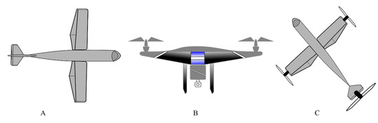
There are various RPAs in the commercial market to date including for military use but based on the use of RPAs in agriculture, they are largely categorized into rotary wing and fixed wing RPAs, Figure 1. Although both of these kinds have their own benefits and limitations. For example, structurally simple fixed wing RPAs lack hovering and require a runway for take-off and landing while offering high-speed flights for longer durations. Whereas, with structurally complex rotary wings RPAs exhibit low-speed flights for shorter duration, they are also capable of hovering, vertical takeoff, and landing with nimble maneuverability [22].
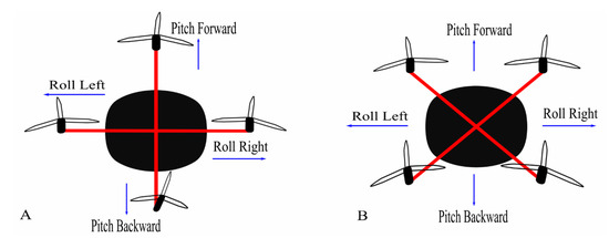
There is also a notable difference in the landing gears of fixed wings and rotary wings RPAs as the former ones may use wheels or magnetic levitation while the later ones have simple supporting structures. The rotary winged RPAs can further be of a helicopter, quadcopter, hexacopter, and octocopter, based on the number of rotors they have. The rotor movements are responsible for the lift of these copters as two of the four rotors, in a quadcopter specifically, move in clockwise direction and other two in the anticlockwise direction. Two configuration models plus (+) and cross (X) are used in quadcopters, of which the latter is more stable and common than former [22] (Figure 2).
With the developing technologies and invention of novel sensors, drones are finding numerous application in agriculture field. The ease and autonomy that RPAs offer is their prominent feature. For example, they can either be flown manually or put on GPS programmed pre-determined paths where learning to pilot is not more than a few hours job with the possibility of one touch takeoff and ground steering. Self-leveling programs further facilitate their autonomy by helping in the acquisition of stabilized images while adjusting the drones to the wind [27]. Few of their most common applications along with novel areas of application are discussed below.
RPAs have been anticipated for counting plants, monitoring growth, phenology and chlorophyll measurement among other potential applications [21]. For this purpose, RPAs like SenseFly’s eBee Ag, having NDVI or near infrared (NIR) sensors, have replaced the conventional farm scouting by significantly minimizing the human error [49]. RPAs are also highly efficient sources of monitoring crops especially in hilly areas that are otherwise challenging for conventional scouting [24]. The most commonly used vegetation indices for crop monitoring and health assessment are summarized in Table 3.

Several vegetation indexes, for example NDVI, are in play to assess the disease, water deficiency or nutrient stress in crops and present useful information like even the presence of algae etc. [15]. Psirofonia, et al. [75] have also reported an effective way of pest or disease infestation detection and mapping in olive and palm plantations, using RPAs. Moreover, the use of drones in the early detection of disease or deficiency in crops has also been suggested to timely mitigate the stress [24].
Recently, Parrot RPA is proposed for effective crop assessment in terms of determination of the density of green on a patch of land. The RPA camera uses the light reflectance from plant (i.e., chlorophyll and leaves) for the determination of their spatial distribution. Following is proposed for calculating NDVI [25]:
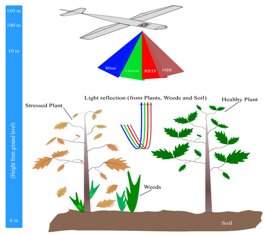
NIR−REDNIR+REwhere, the spectral reflectance measurements acquired in near-infrared and red regions are indicated by NIR and RED respectively. Higher the value of NDVI, the denser and healthier will be the vegetation. Whereas the range of NDVI varies from −1 to +1. Although, different cameras provide different NDVI values for the same field and time of flight, which could mislead the user. Agricultural cameras, however, can provide a standard NDVI that is comparable to other agricultural cameras such as those on satellites. An illustration for a drone equipped with NIR and other sensors for taking data from soil, plant and weeds is presented in Figure 6.
The data collected by crop monitoring, if integrated with soil fertility and weather forecast data, can predict harvest time and yield of crop that in turn can be a vital source for bureaucrats and farmers to accordingly plan for storage and marketing [24].
For refining variable-rate applications (VRA) like Potassium, Phosphorus and Nitrogen, satellite or ground-based images are considered more useful although RPAs do have their uses. For example, drone generated VRA maps are reported to be useful for in-season fertilizer applications on corn and other crops thereby adding up for increased yield [49]. Similarly, novel VIs are being investigated for remote detection of macronutrients. For example, hyperspectral remote sensing was used to monitor N, P and S in Oryza sativa L. reporting novel spectral algorithms especially for P (P_670_1092 and P_670_1260) and S (S_670_1090), as the previously reported VIs did not entail better accuracy for them [76]. Such advancements are really productive in precision agriculture favoring accuracy in real time monitoring. Figure 7 represents the practical example of the data taken for a field of olive plants, using multispectral camera (Parrot Sequoia) mounted on Yuneec Typhoon H hexacopter drone flown on a height of 40 m, and the recommended areas of treatment depending upon the generated maps.
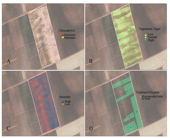
Figure 7. Drone generated maps for olive crop using QGIS. (A) Map for ‘chlorophyll a’ representation generated based on GNDVI. (B) Map for vegetation status generated based on NDVI. (C) Map for humidity contents of the crop generated based on NDWI. (D) Representation of recommended treatment zones in the crop field. (Images facilitated by MC Biofertilizantes).
There is a possibility that crop withering and destroying pathogens evade detection due to the lack of careful inspection. Here comes the role of drones as they can easily distinguish the yellowing plants from the green ones [77]. In a study where drone was used to monitor the canola crop, the mapped region was reported to exhibit reductions in NDVI and leaf area index (LAI) hinting towards its inspection for nutrient deficiency, so that the subsequent pest and disease can be detected beforehand [17].
Another captivating use of drones is monitoring airborne pathogens (e.g., Phytophthora or Fusarium). For this purpose, spore samples are collected using drones that later are grown in the laboratory and analyzed by the researchers. Virginia Tech University is undertaking this novel project [27].
An interesting use of drones is their potential in bird control strategies that is significant problem in agricultural community. Here too, drones have been demonstrated as an effective remedy to psychologically fight off the bird pests in vineyard, where ravens, silvereyes, and cockatoos were kept off [78].
RPAs are also serving to save water in agriculture. For substantial growers having various outstretched fields, management of multiple irrigation pivots is a quite a challenge. For example, in case of sorghum or jowar crops when they acquire certain heights, the watering system (the nozzles and sprinklers) observation becomes a critical task. Therefore, the use of RPA technology comes in handy for such situations by providing useful information for precise application of water quantities in the required area. For example, studies on apple crop with half of the field irrigated and the rest under water stress, resulted in establishment of substantial correlation between drone thermal images and radiometers’ measured field data, where the trees under stress demonstrated significantly higher temperatures [79]. Furthermore, farmers can efficiently opt for various rates of irrigation water instead of the same rate throughout the field thus avoiding water wastage, provided the right irrigation technology [49]. Furthermore, irrigation scheduling has also been proposed based on the data obtained through drones [24].
Drought and irrational water use are provoking water scarcity in California, thus requiring the formulation of modest irrigation management strategies [21]. In this respect, use of drones can do the job. As for instance, satellite-derived evapotranspiration (ET) maps and the ratio of real ET to reference (f RET) based on images of the Earth’s surface temperature (LST) from remote sensors have been reported very useful to control crop water use and stress in vineyards [80]. This suggests that using high-resolution images from drones, better evapotranspiration maps can be established thus favoring precision agriculture. Currently available evapotranspiration (ET) models that estimate ET with the use of drone technology require, in addition to the selected Red and NIR spectral filters, the incorporation of a temperature sensor along with information from the local weather station [21].
It is commonly found that the water absorption is uneven i.e., some parts may get missed while others may work faster. Thermographic and spectroscopic studies can disclose the dry point of crop wilting. Apart from these, imaging can also serve the purpose by the detection of leaks. To effectively assess the topography of the land, farmers can benefit from the laser scanning technology or software capable of stitching hundreds of high-quality aerial imageries into 3D maps. These 3D maps thus generated indicate the water flow direction at the bottom of each tree in the orchard along with the identification of other features [77].
The chemicals or pesticides used in agriculture usually get absorbed by the crops and natural resources including water and soil and ultimately become part of the food chain thereby inflicting severe health impacts and pollution risks for the environment. The excessive use of fertilizers is further responsible of soil degradation, loss of soil fertility and subsequent degradation of water-related ecosystems. Therefore, RPAs have the potential to minimize such dangers by helping in the administration of fertilizers and pesticides in the specifically needed area rather than throughout the field. Such smart and targeted irrigation and fertilization using RPAs is previously reported [15]. Employment of RPAs in spraying fertilizers also paves the way towards sustainable agriculture. Not only this, their operation rate is faster and cheaper as compared to other methods [24]. Psirofonia, et al. [75] reported a very sophisticated use of RPA (DJI Phantom 3) to spray pesticide in the nominated areas using electronic traps (E-Traps), which counts the insects and transmits the data to the server that in turn directs the RPAs. Similarly, an efficient use of drone was reported to control Spodoptera frugiperda, an invasive sugarcane crop pest, by spraying pesticides with the help of 3WWDZ-10A, XAG [81]. Considering these studies, it is evident that RPAs promise efficiency and low-cost in agriculture field.
A variety of sensors can be mounted on RPAs that can help in the acquisition of soil related data i.e., fertility levels of the soil, terrain conditions, nutrients content and moisture content. This data further helps in management decision, planning, fertilizer application, irrigation scheduling etc. [24]. Soil moisture at the spatial surface can be an important indicator of crop conditions in cultivation lands, but its continuous estimation remains a challenge due to the approximate spatial and temporal resolution of existing remote sensing products [21]. However, environmental conditions, calibration, and terrain settings can affect the measurements from sensors. Similarly, a novel methodology, which can pave the way to minimize the erosion problem in agricultural fields, was proposed for the classification of the field’s plowing depths using an RGB-D sensor capable of easy integration into commercially available RPAs [82]. The other useful feature of RPA is that the problems of plough pan formation and subsoil compaction can be effectively avoided if RPAs are used for spraying and sowing purposes [24]. Thus, conserving the soil for better yield.
Likewise, the excessive crop residues are mostly set to fire, thereby degrading soil and adding up to environmental pollution. Using RPAs for spraying decomposing microbial formulations on crop residues is an effective and environmentally friendly way to manage the crop residues [24].
It is a common problem that farmers do not have an idea of how critical the weed issue was until they harvest their crop. By the mercy of drones, this problem can efficiently be resolved by identifying the high-intensity weed growth regions and distinguishing them from healthy crops [49]. RPAs have also been proposed effective for timely removal of weeds to avoid resource depletion for the actual crop [24].
The use of drones for weed mapping encounters two major challenges: (a) distinction between vegetation and bare soil, (b) distinction between weeds and crops. To overcome these, three types of spectral values (i.e., weeds, crop and bare soil) are extracted from pre-defined sampling areas [25]. Similarly, herbicides resistant weeds can also be identified using data obtained by the mercy of agricultural RPAs [77]. This can effectively pave the way to precision agriculture. Furthermore, RPAs can also be used to direct field robots to remove weeds [19].
RPAs can effectively predict and indicate the optimum harvesting time of a crop or fruit by analyzing the data taken by crop monitoring [24]. Few scientists have also proposed their application for fruit picking and aerial transport [19] that need further research in this field. A practical example of this application is the prediction of maize yield using MiniMCA12 camera [83]. More and more studies are being undertaken in this domain, as yield prediction is an indispensable factor for both the farmer and the insurance companies.
In case of a natural disaster, it is very difficult to survey the large fields and obtain the accurate data for insurance companies. RPAs are highly efficient for insurance companies in aiding them to rank the percentage of field damage i.e., 70% or 90%, after a natural disaster [27]. They also serve in saving a lot of material resources, manpower and thus considerably reducing claim time limits [77]. The use of drones for survey purposes aimed for state governments and insurance companies is also reported [24]. It is evident that drone technology is being incorporated into the agriculture sector through the doors of insurance companies as it meets their economic ends.
Robots can serve as pollinators. Although bee robots may not be of that much help, they do have the potential of lending a hand to real bees. Recently, a pollen dump drone pollinating fruits (i.e., apples, cherries and almonds) was developed by a New York based startup that is optimistic about its future sales. Similarly, a few fruit growers are also hopeful of the possible application of RPAs in their orchards [77].
Global warming is a pressing issue now a days. One way to combat this problem is by planting new trees. RPAs are the best option here as they are labor cost effective and save humans from the drudgery. Not only for trees or forests, they can be implied for sowing crops thereby saving fuels and helping to reduce greenhouse gases emissions, as tractors will not be used. Biodegradable seedpods or seed bombs can also be delivered using RPAs for reforestation and for afforestation activities likewise [24].
Initially, drones were employed for managing and monitoring forest fires. Even an RPA, capable of flying up to 24 hours, was presented by the US Forest Service and National Aeronautics and Space Administration (NASA). This shows the quick adoption of RPA technology in this field. Additionally, other areas of RPAs application in forestry includes research applications, mapping canopy gaps, quantifying spatial gaps, mapping forests and biodiversity, measuring forest canopy height and attributes, precision forestry and sustainable forest planning management, mapping diseases and estimating post-harvest soil displacement [84,85]. One such example is the high-throughput phenotyping approach that was implied to examine the phenology in the seedlings of conifer [86].
By late-90s, cattle employment was added by many farmers to diversify their farms during the days of low commodity rate. Drones are equally serving this field of agriculture. Their uses include monitoring herds for their health and protection particularly during night [49]. For example, an automated activity tracking of goats was achieved using drone [87]. Similarly, drones also facilitate the ranchers to monitor the animals at a distant pasture [27]. Equally, drones equipped with night cameras and thermal imager also help to find the herd attacking and harassing animals. In the same way, human poachers can also be monitored by these drones. One such example is their practically employment in Kaziranga National Park India [77]. Another use of drones using thermal cameras is stipulated as geo-fencing [24].
At the beginning of the use of RPAs, it was projected that these technologies would be closely integrated into agricultural activities at an accelerated rate and would become a ubiquitous and low-cost tool for such operations [21]. However, several years later, it is widely recognized that this available technology has not yet been integrated into agriculture as expected despite the multiple offerings of the platform. Farmer’s lack of awareness, complexity of use and higher costs are few of the reasons for slower adoption of this technology in agriculture sector. Although their price start from as low as $10 but in the context of agricultural RPAs it is not the case. For a starter system, agricultural drones can range from $1000 and depending upon the cameras and other features can go up to $10,000 or $20,000 [27]. For smallholder farmers, such costs are an impeding step towards the adoption of this technology.
Nevertheless, drones are regarded as cost effective as they pay for themselves in few usages considering the larger land holdings. Usually there is a possibility to replace their parts in case of a crash. Similarly, they are fairly cost effective as compared to per hour price of a piloted airplane, and application of fertilizers and pesticides further adds up into the cost effectiveness [27]. One such example of cost effectiveness, of using drones, is reported by Psirofonia, et al. [75] where they used drones to spray pesticide. In another study, three RPAs models, eBee (fixed wing), Phantom 2 (rotary wing) and X8 (fixed wing), were tested to monitor palm cultivation for oil extraction. Infrared images were used to monitor punning and disease identifications. Of these eBee equipped with NIR was reported as an efficient model in monitoring pathologies e.g., analysis of chlorosis. Although eBee was reported expensive economically, with flight time of 45 min and coverage of 100 ha per flight at 150 m altitude. The Phantom 2 was regarded as cheapest economically, with flight time of 25 min and coverage of 12 ha per flight at 150 m altitude. The X8, having a flight time of 45 min and coverage of 100 ha per flight at 150 m altitude, was regarded in medium range economically [17].
Another excellent example where RPAs are efficiently aiding in the economy is weed management. A cost of 16–45 € per ha was saved by efficient use of herbicides in in maize field based on the RPA post-emergence image data [88]. This study also strengthens the efficiency of PA thereby not only reducing the input costs but also ensuring the uniformity of application. Similarly, the use of RPAs in forestry for recording the vegetation dynamics was regarded as highly economical given the possibility of their year-round use and providing high resolution images [89].
RPAs do promise a high temporal and spatial resolution but considerably lower spectral resolution, as it depends upon the amount of spectral ranges or bands and the sensor detected wavelength. Sensors are usually costly and thus make a RPA expensive. A low spectral resolution sensor is cheaper, with red (0.62–0.70 μm), green (0.49–0.58 μm) and blue (0.45–0.49 μm) bands and taking images only in visible range, as compared to a multispectral sensor that also measures the infrared (IR; 0.78–10.0 μm) bands thus providing a better vegetation index, i.e., such as NDVI. Sensors measuring thermal radiations from mid-infrared (MIR) to the far-infrared (FIR) are also available based on their perspective use [17].
NIR cameras have been used in several studies [38,46,88,90,91,92], although these sensors are costly. For this reason, cameras with only visible bands are preferred [36,37,92,93] that are relatively cheaper. Consequently, a modified photochemical reflectance index (MPRI) using only red and green band was proposed. A study was undertaken in São Carlos to investigate the temporal and spatial variability of the MPRI vegetation index of grass, and demonstrated its potential for grass cultivation management and control [17].
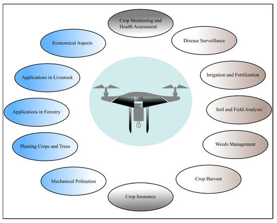
In another study of wheat mapping, six spectral indices including VEG, CIVE, Woebbecke index, ExGR, ExG, and NGRDI were studied using a RPA carrying a conventional low-cost camera. Of these, VEG and ExG with values varying from 83.74% to 87.82% at 60 m flight altitude and from 87.73% to 91.99% at 30 m flight altitude were regarded as optimum [37]. Similarly, a study reported the use of conventional RGB camera but with its red filter removed. Thus, modifying the camera to capture green, blue and NIR bands that promise a useful tool for plant health, vegetation and phenology monitoring [17]. Such findings are further straightening up the way for making the technology more efficient and economically accessible for small farmers for real time inspections, monitoring and decision-making. With rapid progress of technological inventions, sensors, cameras, gimbles and basic RPA architecture are becoming more and more efficient, thus promising a greener and more sustainable agriculture. A summary of applications of drones in agriculture is presented in Figure 8.