1000/1000
Hot
Most Recent
 +1 point
Wind forecasts are widely spread because of the growth in wind power, but also because there are other applications to consider, such as the long-term scenario forecasts regarding the effects of global warming. Overall, there have been big developments in global circulation models (GCM) that inform future scenarios at the large scale, but wind forecast at a local scale is a problem that has not totally been solved.
Traditionally, weather forecast models, and specifically wind forecast ones, have the main feature of working at large spatial scales, for example, as General Circulation Models [1]. All these models are designed for perform over large areas, and the problem is to know the real effects of the wind over a scale of a few kilometres. New techniques have been developed to obtain local data from large-scale information in an accurate way. These kinds of techniques are known as regionalisation techniques, scale reduction techniques, or downscaling techniques [2]. Between them, the transfer functions are a type of regionalisation technique based on the statistical regression relationship between the large and local scales. This regression allows an approach for the local weather to be predicted from the models developed at a large scale, but it does not seem that these functions have been developed directly from the meteorological data series and with the enough accuracy to be reliable.
For that matter, a wind transfer equation based on regression and made from data series, terrain and atmosphere parameters could be posed for local scales. Figure 1 depicts the general idea for this wind data transference in reduced areas or at small scales.
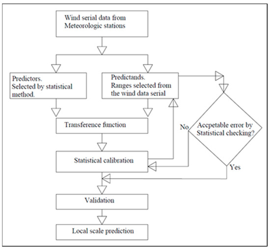
Figure 1. Basic flowchart for the local-scale issue.
So far, large-scale circulation models and the forecast from these for both large and regional scales have been widely developed. Representative examples of these include the wind field evaluation for surge storms in the Persian Gulf [3] and the achievement of wind speeds for a river basin in India from a GCM [4]. However, the question is to solve the impact of the climatic actions—in this case the wind—when it is acting over different local systems (harbours, shorelines, dunes, wind farms and beach geomorphology).
The methodology is focused on the study of different papers to investigate the development of wind models and aims to select those that contribute applicable tools to get the parameters on a regional scale, not only from the global circulation models (GCMs) but also from meteorological stations near the study area. The investigation explores the different alternatives along with several ways to solve the problem depending on the area where the local wind was analysed. The point is to find which models have developed a wind transfer function on a scale of a few kilometres. For this purpose, the different downscaling applications normally used have firstly been identified. Table 1 provides a summary of them.
Table 1. Typology of the downscaling applications. Source: Adapted from Pielke and Wilby [5].
| Purpose | Inputs to Regional Downscaling |
|---|---|
| Short-term prediction | Observed data and regional conditions analysis |
| Regional Simulation | Information from global reanalysis without considering initial conditions |
| Seasonal Prediction | Global model prediction from observed conditions |
| Climate Prediction | Multidecadal global prediction based on radiative forcing |
The downscaling techniques can be separated into two groups, which include, on the one hand, dynamic downscaling or DD [6], and on the other hand, statistical downscaling or SD [7]. A brief but accurate definition was extracted from the Geophysical Fluid Dynamics Laboratory web (https://www.gfdl.noaa.gov/): DD refers to the use of high-resolution regional simulations to dynamically extrapolate the effects of large-scale climate processes to regional or local scales of interest. In the so-called dynamic downscaling, high-resolution fields are obtained by nesting a regional climate model (RCM) within the GCM [8] or using a variable resolution GCM (the so-called stretching technique) [9]. SD encompasses the use of various statistics-based techniques to determine the relationships between large-scale climate patterns resolved by GCMs and the observed local climate responses. In statistical downscaling [10], the high-resolution predictands (surface variables) are obtained by applying previously identified relationships in the observed climate between these predictands and large-scale predictor fields to the outputs of the GCMs. Table 2 shows the advantages and disadvantages of both methods where some have been adapted from Climate Workspace (http://www.glisaclimate.org/) and other authors [11][12][13][14][15][16][17][18]:
Table 2. Advantages and disadvantages of statistical downscaling (SD) and dynamic downscaling (DD).
| Statistical Downscaling | Dynamic Downscaling | |
| Advantages |
|
|
|
|
|
| Disadvantages | Two major disadvantages exist:
|
|
|
||
|
|
The several reviewed papers lead to the conclusion that SD is the technique to be applied to reduced areas. The main reasons are its feasibility and ability to diagnose at local scales, as well as performing over different time scales [19]. The dynamic downscaling and its different types [13] are still not the final solution, such as a way to predict wind in near field, because of the different aspects such as the atmospheric/oceanic boundary conditions, circulations, or the limited spatial resolution [5]. Additionally, DD is practically the same as GCMs but with a higher resolution. This implies the DD is computationally intensive and requires large volumes of data, as well as a high level of experience to implement and interpret the results. Devis et al. [20], already delved into this point after making a comparison between dynamical and statistical downscaling, and the main conclusion found was that dynamical downscaling can be used for regional climatic models between approximately 20 and 50 km, with the boundary conditions provided by a GCM. The statistical downscaling develops important transference functions. These functions relate the great-scale GCM models, with the near field. The main advantage over the dynamical downscaling is the relative ease of use and application in assembly with GCM.
The experience from Puertos del Estado (the state-owned Spanish port system, http://www.puertos.es/es-es) is one of the precedent cases to the achievement of climatic parameters in the near field. It is focused on wave forecasting on the coastal shoreline [21]. The aim of this investigation was to find the waves in the continental shelf as data coming from a GCM, such as the WAM model [22] and SWAN model [23], or SMC [24]. These models predict the waves in coasts, lakes, and estuaries for a certain wind pattern and this propagation can be used in many different fields, for example for the gradation of sand beaches such as that developed by Bernabeu et al. [25]. The problem was solved for Puertos del Estado by dividing the system into two steps: one at an oceanic scale and another at a local scale nested with the first one and introducing a set of applications to solve the problem in the specific port area. Another experience was carried out by Machado et al. [26] on Deception Island, where the model was validated by comparing the simulation results against data collected in several stations inside the domain. The idea may be similar but is applied to the wind, also considering how to proceed from meteorological station data series whilst taking advantages from previous conducted investigations. Therefore, the methodology consists of selecting the research that contributes applicable findings. These will be developed in a future line of research.