Submitted Successfully!
To reward your contribution, here is a gift for you: A free trial for our video production service.
Thank you for your contribution! You can also upload a video entry or images related to this topic.
Version Summary Created by Modification Content Size Created at Operation
1 + 2407 word(s) 2407 2021-09-29 10:30:30 |
2 format corrected. Meta information modification 2407 2021-09-30 14:27:52 | |
3 Roll back entry to make some changes. Meta information modification 2407 2021-10-08 11:26:36 |

Video Upload Options

Do you have a full video?

Confirm

Are you sure to Delete?
Cite
If you have any further questions, please contact Encyclopedia Editorial Office.
Yu, L.; Zhao, Q. Application of Google Earth Engine. Encyclopedia. Available online: https://encyclopedia.pub/entry/14783 (accessed on 20 April 2024).
Yu L, Zhao Q. Application of Google Earth Engine. Encyclopedia. Available at: https://encyclopedia.pub/entry/14783. Accessed April 20, 2024.
Yu, Le, Qiang Zhao. "Application of Google Earth Engine" Encyclopedia, https://encyclopedia.pub/entry/14783 (accessed April 20, 2024).
Yu, L., & Zhao, Q. (2021, September 30). Application of Google Earth Engine. In Encyclopedia. https://encyclopedia.pub/entry/14783
Yu, Le and Qiang Zhao. "Application of Google Earth Engine." Encyclopedia. Web. 30 September, 2021.
Application of Google Earth Engine
Edit

Google Earth Engine (GEE) is a cloud computing platform that was launched by Google in 2010. Since then, GEE has demonstrated its capacity of preprocessing and mining of geographic big data. GEE enables cloud computation and is an effective tool for carrying out the analysis of global geospatial big data.

Google Earth Engine scientometric analysis meta-analysis

1. Introduction

Global environmental change is one of the most critical challenges facing attempts to achieve sustainable development. The concept of Earth system science was first proposed by the Earth System Sciences Committee of NASA (National Aeronautics and Space Administration) in the 1990s [1]. This interdisciplinary science emerged to address global environmental change in a way that was systematic and integrated. Yu and Gong [2] identified three challenges facing traditional geographic information science (GIS): (1) the 3D global representation and visualization of geospatial data from local to global scales; (2) the preprocessing and mining of geographic big data; and (3) spatial-temporal techniques for research into geographic processes. There is an urgent need to make significant technological advances to solve global environmental problems [2]. In connection with this, the use of Google Earth Engine (GEE) to analyze environmental problems at global scales is becoming common.

Google Earth Engine (GEE) is a cloud computing platform that was launched by Google in 2010 [3]. Since then, GEE has demonstrated its capacity to address the second challenge listed at the beginning of this section. GEE enables cloud computation and is an effective tool for carrying out the analysis of global geospatial big data. Other cloud platforms that can be used for processing geospatial big data include Amazon Web Services (AWS, released in 2006) and Microsoft Azure (released in 2010) [4]. Compared with other cloud platforms, GEE supports more types of geospatial data (for example, Sentinel and early Landsat data) and provide services free to all users, which is especially important in less developed countries. GEE is currently the most popular cloud computing platform in Earth system science and was extensively used to process data related to a variety of fields concerned with environmental change, including agriculture [5][6][7][8][9], water [10][11][12][13][14], land cover/land use [15][16][17][18], disasters [19][20][21][22][23], climate change [24][25], soil [26][27][28][29], wetland [30][31][32][33][34][35], forest [36][37], and urbanization [38][39][40][41] as well as other fields [4][42]. GEE provides users with publicly downloadable Earth observation data at the petabyte scale, advanced algorithms for analyzing geographic big data, and an interactive programming environment. GEE also hosts long time-series of Earth observation records and plays a vital role in environmental monitoring and analysis [3]

2. Scientometric Analysis

We used“Google Earth Engine” as keywords to retrieve relevant articles and review articles from the Web of Science (WoS) (https://www.webofscience.com/ ) core collection, including the SCIE (Science Citation Index Expanded) and SSCI (Social Sciences Citation Index), dated up to January 2021. After screening, 565 articles related to “Google Earth Engine” were obtained.

Most of the analysis is based on CiteSpace, a powerful bibliometric analysis software [43]. CiteSpace can analyze document co-citations, keyword co-occurrences, and cooperative maps, thus enabling the exploration of knowledge base, structural frameworks, and research frontiers in research that is based on GEE. These types of analyses can provide a basis for the subsequent application and development of GEE.

2.1 Statistical Characteristics

GEE was launched in 2010; however, it was difficult to make use of GEE in scientific research until 2015. As a result, there were few relevant publications or citations made during the period 2010–2015. After 2015, the number of publications and citations increased exponentially, due to the significantly improved interface, data cube, and programming environment.

The journals that published papers on GEE were mainly thematic. A total of 565 papers referencing GEE were published in 121 journals, and the top ten journals accounted for 62% of the total (Figure 1). These ten were Remote Sensing (194), Remote Sensing of Environment (65), the ISPRS Journal of Photogrammetry and Remote Sensing (18), the IEEE Journal of Selected Topics in Applied Earth Observations and Remote Sensing (16), the International Journal of Applied Earth Observation and Geoinformation (12), the International Journal of Remote Sensing (10), the ISPRS International Journal of Geo-Information (10), Water (10), PloS One (9) and Sustainability (8). This means that the journals Remote Sensing and Remote Sensing of Environment accounted for 46% of the total. Of the 121 journals, 68 published only one paper on GEE. Publications on GEE were mostly about remote sensing, geo-information, and the environment.

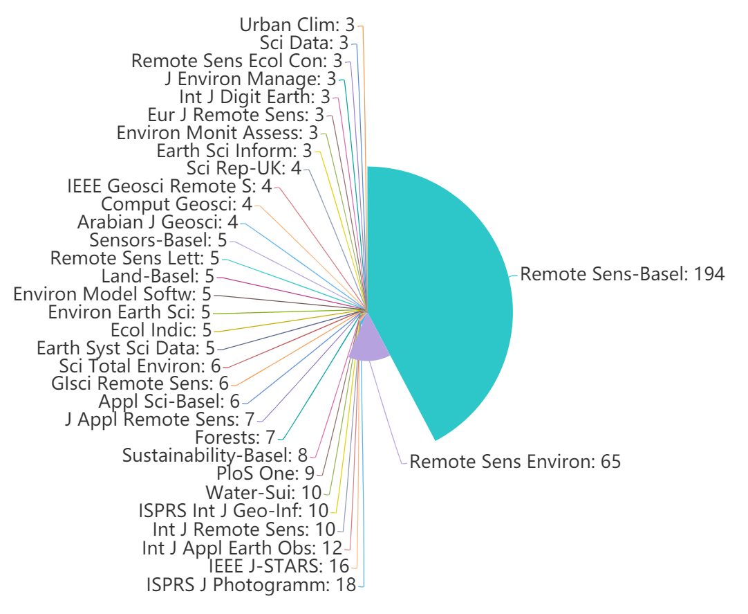
Figure 1. Journals in which papers related to GEE were published

The number of research disciplines covered by the GEE publications was far fewer. The 565 papers on GEE covered only 35 of the WoS disciplines and were concentrated in fewer disciplines than the GE papers. The research areas with more than 100 publications were environmental sciences and ecology (365), remote sensing (363), and imaging science and photographic technology (129). These three research areas alone accounted for 70% of the total (Figure 2).

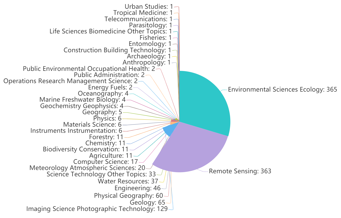
Figure 2. Research disciplines in which GEE was applied

2.2 Subject Structure Analysis

According to the analysis of keywords in the literature on GEE (Figure 3), it was found that “Remote sensing”, “Regions”, and “Landsat Satellite” appeared most frequently—203, 197, and 189 times, respectively. GEE has been used to collect various types of open-source geographic information, including remote sensing data, data on land-surface conditions, and other relevant derived products that are freely accessible to users. However, there are several limitations on the use of datasets in GEE: e.g., the data sets stored in GEE are not comprehensive (such as complex SAR is not included), and there is a limit to the amount of user-uploaded data that can be stored. From Figure 3, it can be seen that the most frequently occurring keywords include “Water”, “High Resolution”, “Management”, “Random Forest”, “Algorithm”, “Cloud Platform”, and “Model”, which appear 174, 165, 154, 134, 129, 126 and 124 times, respectively. The machine-learning algorithms in GEE allow for convenient data processing and information extraction. However, there are still some types of image-processing algorithms that are not supported by GEE, such as Gaussian and Laplacian filters, edge-detection methods, and frequency domain algorithms [3]. Due to the advantages that GEE has in processing geographic big data, the use of GEE makes it simpler and more efficient to obtain annual regional geographical information [4].

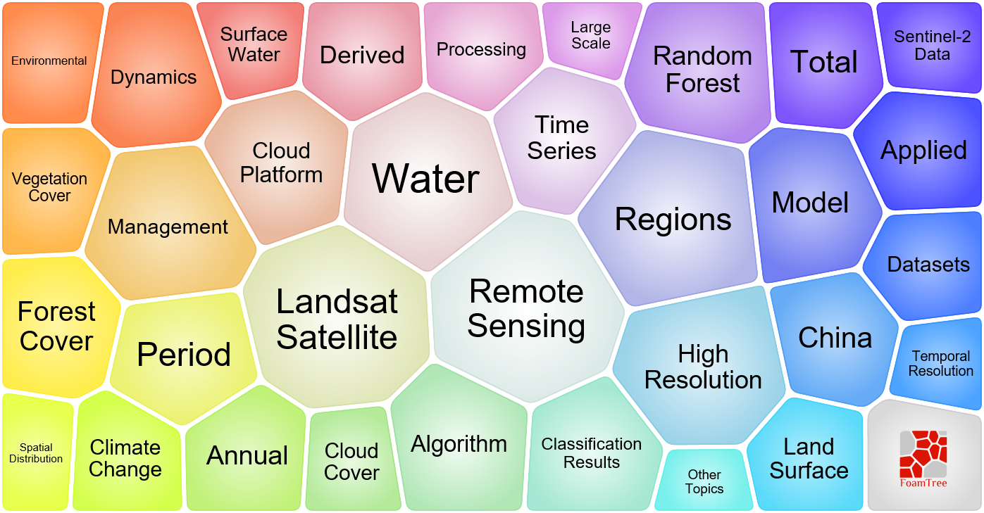
Figure 3. Keywords related to GEE

Papers describing the application of GEE began to appear in 2015 (Figure 4), and, since then, many keywords have appeared, including “GEE”, “Landsat”, “Land Cover Change”, “Classification”, “Cover”, “Image Classification”, “Area”, “Forest”, “Map”, “Cloud Computing”, “Time Series”, “Remote Sensing”, “MODIS”, “Vegetation”, “China”, “Algorithm”, “Climate”, “Random Forest”, “Sentinel”, and “Dynamics”.

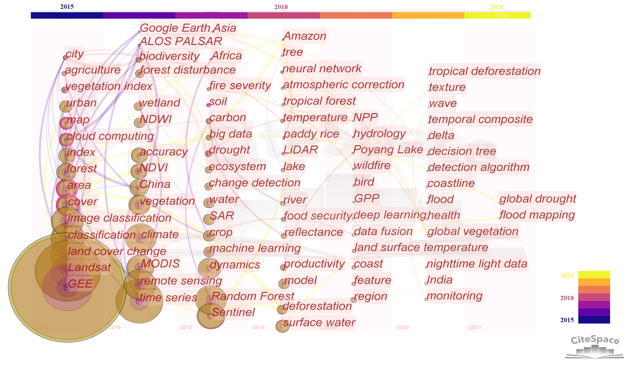
Figure 4.  Co-occurrence keywords were used in relation to GEE. The size of the node represents the frequency of the occurrence of the keyword, the connecting lines indicate the co-occurrence relationships for the keyword, and a purple outer circle indicates that the node is a key node (betweenness centrality > 0.1).

2.3 Research Contribution Analysis

Table 1 lists the cited papers that were found to have the strongest citation bursts in GEE articles. GEE is a cloud computing platform that has the capacity to provide and process geographic big data and provides an excellent platform for carrying out global land cover research [44][45][46]. Landsat data are a vital source of satellite imagery that is available on GEE. Roy, et al. [47] evaluated the capabilities of Landsat 8 data and identified new opportunities for scientific research and applications using these data. This paper also laid a solid foundation for the application of Landsat 8 remote sensing data in resource management and global change studies using GEE. An important characteristic of GEE is the availability of geographic big data. Wulder, et al. [48] explained the role of free data in promoting new scientific research, applications, and international collaboration on Earth observation. GEE’s integration of a range of accessible geographic data (including Landsat [47], Sentinel [49], and MODIS [50] data) also promotes progress in Earth system science. Studies on various image processing and geophysical dataset acquisition methods have become the main driving force behind the promotion of the application of GEE [51][52][53][54].

Table 1. GEE papers with the strongest citation bursts

Article

Author

Year

Strength

Begin

End

High-Resolution Global Maps of 21st-Century Forest Cover Change [45]

Hansen, MC

2013

24.13

2015

2018

Finer resolution observation and monitoring of global land cover: first mapping results with Landsat TM and ETM+ data [44]

Gong, P

2013

6.46

2016

2018

Good practices for estimating area and assessing accuracy of land change [46]

Olofsson, P

2014

5.36

2016

2019

Landsat-8: Science and product vision for terrestrial global change research [47]

Roy, DP

2014

5.06

2016

2019

Opening the archive: How free data has enabled the science and monitoring promise of Landsat [48]

Wulder, MA

2012

4.39

2016

2017

Object-based cloud and cloud shadow detection in Landsat imagery [51]

Zhu, Z

2012

4.39

2016

2017

Development of gridded surface meteorological data for ecological applications and modelling [52]

Abatzoglou, JT

2013

3.7

2015

2018

Automated Water Extraction Index: A new technique for surface water mapping using Landsat imagery [53]

Feyisa, GL

2014

3.65

2018

2019

Sentinel-2: ESA’s Optical High-Resolution Mission for GMES Operational Services [49]

Drusch, M

2012

3.09

2015

2017

Multitemporal settlement and population mapping from Landsat using Google Earth Engine [54]

Patel, NN

2015

2.75

2015

2017

2.4 Cooperation Network Analysis

At the institutional level, Chinese scientific institutions have dominated the application of GEE. The top ten institutions were the Chinese Academy of Sciences (102), the University of Chinese Academy of Sciences (53), the United States Geological Survey (23), Tsinghua University (20), Google Incorporated (18), the National Aeronautics and Space Administration (17), Wuhan University (17), the University of Oklahoma (15), the United States Forest Service (13), and the China University of Geosciences (12). The number of published papers from Chinese scientific institutions was far greater than that from institutions in other countries.

At the national level, the number of publications was more concentrated. The top five countries published 526 GEE papers (including duplicates), which accounted for 57.9% of the total number of published papers. The top five countries, in this case, were the USA (229), China (203), the United Kingdom (43), Australia (31), and Canada (31). In summary, the United States and China have dominated the application of GEE, and have published a considerable number of related papers, as compared to other countries. According to Nature Index (https://www.natureindex.com/ ), the United States and China have the largest number of scientific institutions (2637 and 1485, respectively) and published articles (29,207 and 19,084, respectively in 2020) in high-quality peer-reviewed journals. These top-ranking countries produce high-quality research output and participate in high-quality collaboration, which supports our results. Although the United States is not as prominent in terms of the number of published papers at the institutional level, it has many high-level scientific institutions and is important in terms of the number of published papers at the national level.

3. Current Insights

Cloud computing has emerged as a popular research topic in recent years. It was widely applied to geospatial big data, and a large number of remote sensing cloud computing platforms were launched. AWS is a comprehensive and widely adopted cloud platform that was developed earlier than GEE and provides a large number of application program interfaces (APIs) [3][55]. Microsoft Azure is a platform contemporary with GEE that provides machine-learning services [3][4]. AWS and Microsoft Azure are both pay-as-you-go platforms [3]. NASA Earth Exchange (NEX) works in a virtual environment to ensure maximum ease-of-use and reproducibility [56]. GEE provides a larger number of geospatial data sets than all of these platforms. Although the API of GEE includes only JavaScript and Python, it is able to meet the needs of most users [55]. Gomes et al. [57] made detailed comparisons of other cloud computing platforms, such as Sentinel Hub (SH), Open Data Cube (ODC), and OpenEO. They believed that GEE is an easy-to-use and mature remote sensing cloud computing platform, and that the data abstraction, physical infrastructure abstraction, processing scalability, and storage scalability provided by GEE stand out as advantages over existing platforms. ODC is currently the best available solution for geospatial big data and has significant advantages over GEE in terms of open governance, infrastructure replicability, data access interoperability, and extendibility. Due to the ease-of-use and maturity of GEE, it was used more widely in Earth system science than other platforms (with the number of relevant articles retrieved from WoS being 14 for AWS, 3 for Microsoft Azure, 34 for NASA Earth Exchange, 5 for SH, and 3 for ODC).

GEE is a advanced platform that has stronger cloud computing power (Table 2). Although GEE is not a virtual Earth, the technologies available in GEE can support the development and improvement of the virtual Earth. The main part of GEE (the Earth Engine (EE) Code Editor) is a web-based interactive development environment (IDE) for the Earth Engine JavaScript API, which develops complex geospatial workflows. At present, GEE supports a web APP (EE Explorer), which has limited functionality. In the future, it may be possible to develop an APP that is convenient for all users by, for example, optimizing the visualization of GEE and adding more data interfaces that can accept different types of geospatial data (such as geospatial data collected in real-time). GEE runs calculations as scripts, which is not convenient for users carrying out complex procedures or who require transitional data sets. It would be an improvement if users could control more of the data processing and if there was an interface of modules that could directly combine different tools. It is also important to increase the necessary data and algorithms mentioned in Table 2.

Table 2. Merits and limitations of GEE

Merits

  • Freely accessible data collections [3][4][42]
  • Capable of geospatial big data analysis based on Google’s substantial computational capabilities [3][4][42]
  • Image-processing algorithms are supported [3][4][42]
  • JavaScript and Python API supported [3][4][42]
  • Cloud platform: performance requirements for the user’s computer are low [3]

Limitations

  • Privacy issues in relation to private data [3]
  • Limited upload and download speeds [3]
  • Supported algorithms are not comprehensive (e.g., deep learning algorithms are not available) [3]
  • Limited numbers of training samples and validation samples for large scale classification [3]
  • SAR data (except Sentinel-1) and high-resolution (except National Agriculture Imagery Program (NAIP) and Planet Skysat) data are not supported [3][4]
  • Memory issues and storage limitations affect computational abilities [3][4][42]
  • Difficult to use; developing new tools is not easy [3]
  • Simulation of complex geographical processes remains a challenge [58]

GEE has a comprehensive range of functions. It also has the capability to analyze geospatial big data, provides a greater number of geospatial data sets, and supports various image-processing algorithms. Still, the visualization capability of GEE is not an advantage. GEE’s modeling capabilities (simulation of complex geographical/ecological processes, such as urban expansion modeling and vegetation dynamic modeling) are limited. It also lacks complex SAR and high-resolution geospatial data sets and the ability to perform optimization. Complex algorithms are difficult to implement, and optimization algorithms are implemented locally. At present, the development of GEE is still in its infancy. Nonetheless, it is undeniable that GEE has the potential to become an effective tool for use in Earth system science. Significant improvements in the supporting technology are needed, however. The addition of more computing resources, more open-source data sets, more image-processing algorithms, and the contributions of more Earth system scientists will allow GEE to become an effective tool that combines monitoring, modeling, analysis, assessment, and management decisions that can be applied to solve global environmental problems.

References

  1. NASA Advisory Council, Earth System Sciences Committee. Earth System Science Overview: A Program for Global Change; National Aeronautics and Space Administration: Washington, DC, USA, 1986; pp. 56.
  2. Le Yu; Peng Gong; Google Earth as a virtual globe tool for Earth science applications at the global scale: progress and perspectives. International Journal of Remote Sensing 2011, 33, 3966-3986, 10.1080/01431161.2011.636081.
  3. Meisam Amani; Arsalan Ghorbanian; Seyed Ali Ahmadi; Mohammad Kakooei; Armin Moghimi; S. Mohammad Mirmazloumi; Sayyed Hamed Alizadeh Moghaddam; Sahel Mahdavi; Masoud Ghahremanloo; Saeid Parsian; et al.Qiusheng WuBrian Brisco Google Earth Engine Cloud Computing Platform for Remote Sensing Big Data Applications: A Comprehensive Review. IEEE Journal of Selected Topics in Applied Earth Observations and Remote Sensing 2020, 13, 5326-5350, 10.1109/jstars.2020.3021052.
  4. Haifa Tamiminia; Bahram Salehi; Masoud Mahdianpari; Lindi Quackenbush; Sarina Adeli; Brian Brisco; Google Earth Engine for geo-big data applications: A meta-analysis and systematic review. ISPRS Journal of Photogrammetry and Remote Sensing 2020, 164, 152-170, 10.1016/j.isprsjprs.2020.04.001.
  5. David B. Lobell; David Thau; Christopher Seifert; Eric Engle; Bertis Little; A scalable satellite-based crop yield mapper. Remote Sensing of Environment 2015, 164, 324-333, 10.1016/j.rse.2015.04.021.
  6. Jun Xiong; Prasad S. Thenkabail; James C. Tilton; Murali K. Gumma; Pardhasaradhi Teluguntla; Adam Oliphant; Russell G. Congalton; Kamini Yadav; Noel Gorelick; Nominal 30-m Cropland Extent Map of Continental Africa by Integrating Pixel-Based and Object-Based Algorithms Using Sentinel-2 and Landsat-8 Data on Google Earth Engine. Remote Sensing 2017, 9, 1065, 10.3390/rs9101065.
  7. Andrii Shelestov; Mykola Lavreniuk; Nataliia Kussul; Alexei Novikov; Sergii Skakun; Exploring Google Earth Engine Platform for Big Data Processing: Classification of Multi-Temporal Satellite Imagery for Crop Mapping. Frontiers in Earth Science 2017, 5, 1–10, 10.3389/feart.2017.00017.
  8. Jun Xiong; Prasad S. Thenkabail; Murali K. Gumma; Pardhasaradhi Teluguntla; Justin Poehnelt; Russell G. Congalton; Kamini Yadav; David Thau; Automated cropland mapping of continental Africa using Google Earth Engine cloud computing. ISPRS Journal of Photogrammetry and Remote Sensing 2017, 126, 225-244, 10.1016/j.isprsjprs.2017.01.019.
  9. Pardhasaradhi Teluguntla; Prasad S Thenkabail; Adam Oliphant; Jun Xiong; Murali Krishna Gumma; Russell G. Congalton; Kamini Yadav; Alfredo Huete; A 30-m landsat-derived cropland extent product of Australia and China using random forest machine learning algorithm on Google Earth Engine cloud computing platform. ISPRS Journal of Photogrammetry and Remote Sensing 2018, 144, 325-340, 10.1016/j.isprsjprs.2018.07.017.
  10. Chao Wang; Mingming Jia; Nengcheng Chen; Wei Wang; Long-Term Surface Water Dynamics Analysis Based on Landsat Imagery and the Google Earth Engine Platform: A Case Study in the Middle Yangtze River Basin. Remote Sensing 2018, 10, 1635, 10.3390/rs10101635.
  11. Yingbing Wang; Jun Ma; Xiangming Xiao; Xinxin Wang; Shengqi Dai; Bin Zhao; Long-Term Dynamic of Poyang Lake Surface Water: A Mapping Work Based on the Google Earth Engine Cloud Platform. Remote Sensing 2019, 11, 313, 10.3390/rs11030313.
  12. Tim Busker; Ad de Roo; Emiliano Gelati; Christian Schwatke; Marko Adamovic; Berny Bisselink; Jean-Francois Pekel; Andrew Cottam; A global lake and reservoir volume analysis using a surface water dataset and satellite altimetry. Hydrology and Earth System Sciences 2019, 23, 669-690, 10.5194/hess-23-669-2019.
  13. Qi Huang; Di Long; Mingda Du; Chao Zeng; Gang Qiao; Xingdong Li; Aizhong Hou; Yang Hong; Discharge estimation in high-mountain regions with improved methods using multisource remote sensing: A case study of the Upper Brahmaputra River. Remote Sensing of Environment 2018, 219, 115-134, 10.1016/j.rse.2018.10.008.
  14. Yan Zhou; Jinwei Dong; Xiangming Xiao; Ronggao Liu; Zhenhua Zou; Guosong Zhao; Quansheng Ge; Continuous monitoring of lake dynamics on the Mongolian Plateau using all available Landsat imagery and Google Earth Engine. Science of The Total Environment 2019, 689, 366-380, 10.1016/j.scitotenv.2019.06.341.
  15. Huabing Huang; Yanlei Chen; Nicholas Clinton; Jie Wang; Xiaoyi Wang; Caixia Liu; Peng Gong; Jun Yang; Yuqi Bai; Yaomin Zheng; et al.Zhiliang Zhu Mapping major land cover dynamics in Beijing using all Landsat images in Google Earth Engine. Remote Sensing of Environment 2017, 202, 166-176, 10.1016/j.rse.2017.02.021.
  16. Alemayehu Midekisa; Felix Holl; David J. Savory; Ricardo Andrade-Pacheco; Peter Gething; Adam Bennett; Hugh Sturrock; Mapping land cover change over continental Africa using Landsat and Google Earth Engine cloud computing. PLOS ONE 2017, 12, e0184926-e0184926, 10.1371/journal.pone.0184926.
  17. G. Azzari; David Lobell; Landsat-based classification in the cloud: An opportunity for a paradigm shift in land cover monitoring. Remote Sensing of Environment 2017, 202, 64-74, 10.1016/j.rse.2017.05.025.
  18. Hamdi A. Zurqani; Christopher J. Post; Elena A. Mikhailova; Mark Schlautman; Julia L. Sharp; Geospatial analysis of land use change in the Savannah River Basin using Google Earth Engine. International Journal of Applied Earth Observation and Geoinformation 2018, 69, 175-185, 10.1016/j.jag.2017.12.006.
  19. Mohammad Kakooei; Yasser Baleghi; A two-level fusion for building irregularity detection in post-disaster VHR oblique images. Earth Science Informatics 2020, 13, 459-477, 10.1007/s12145-020-00449-6.
  20. Ben DeVries; Chengquan Huang; John Armston; Wenli Huang; John W. Jones; Megan W. Lang; Rapid and robust monitoring of flood events using Sentinel-1 and Landsat data on the Google Earth Engine. Remote Sensing of Environment 2020, 240, 111664, 10.1016/j.rse.2020.111664.
  21. Mrinal Singha; Jinwei Dong; Sangeeta Sarmah; Nanshan You; Yan Zhou; Geli Zhang; Russell Doughty; Xiangming Xiao; Identifying floods and flood-affected paddy rice fields in Bangladesh based on Sentinel-1 imagery and Google Earth Engine. ISPRS Journal of Photogrammetry and Remote Sensing 2020, 166, 278-293, 10.1016/j.isprsjprs.2020.06.011.
  22. Varun Tiwari; Vinay Kumar; Mir Abdul Matin; Amrit Thapa; Walter Lee Ellenburg; Nishikant Gupta; Sunil Thapa; Flood inundation mapping- Kerala 2018; Harnessing the power of SAR, automatic threshold detection method and Google Earth Engine. PLOS ONE 2020, 15, e0237324, 10.1371/journal.pone.0237324.
  23. Ella Meilianda; Biswajeet Pradhan; Syamsidik; Louise K. Comfort; Dedy Alfian; Romy Juanda; Saumi Syahreza; Khairul Munadi; Assessment of post-tsunami disaster land use/land cover change and potential impact of future sea-level rise to low-lying coastal areas: A case study of Banda Aceh coast of Indonesia. International Journal of Disaster Risk Reduction 2019, 41, 101292, 10.1016/j.ijdrr.2019.101292.
  24. Binfei Hao; Mingguo Ma; Shiwei Li; Qiuping Li; Dalei Hao; Jing Huang; Zhongxi Ge; Hong Yang; Xujun Han; Land Use Change and Climate Variation in the Three Gorges Reservoir Catchment from 2000 to 2015 Based on the Google Earth Engine. Sensors 2019, 19, 2118, 10.3390/s19092118.
  25. Tenaw Geremew Workie; Habte Jebessa Debella; Climate change and its effects on vegetation phenology across ecoregions of Ethiopia. Global Ecology and Conservation 2018, 13, e00366, 10.1016/j.gecco.2017.e00366.
  26. J. Padarian; Budiman Minasny; Alex McBratney; Using Google's cloud-based platform for digital soil mapping. Computers & Geosciences 2015, 83, 80-88, 10.1016/j.cageo.2015.06.023.
  27. Raúl R. Poppiel; Marilusa P. C. Lacerda; José L. Safanelli; Rodnei Rizzo; Jr. Manuel P. Oliveira; Jean J. Novais; José A. M. Demattê; Mapping at 30 m Resolution of Soil Attributes at Multiple Depths in Midwest Brazil. Remote Sensing 2019, 11, 2905, 10.3390/rs11242905.
  28. Konstantin Ivushkin; Harm Bartholomeus; Arnold K. Bregt; Alim Pulatov; Bas Kempen; Luis de Sousa; Global mapping of soil salinity change. Remote Sensing of Environment 2019, 231, 111260, 10.1016/j.rse.2019.111260.
  29. J. Padarian; B. Minasny; A.B. McBratney; Chile and the Chilean soil grid: A contribution to GlobalSoilMap. Geoderma Regional 2017, 9, 17-28, 10.1016/j.geodrs.2016.12.001.
  30. Alice Alonso; Rafael Muñoz-Carpena; Robert E. Kennedy; Carolina Murcia; Wetland Landscape Spatio-Temporal Degradation Dynamics Using the New Google Earth Engine Cloud-Based Platform: Opportunities for Non-Specialists in Remote Sensing. Transactions of the ASABE 2016, 59, 1331-1342, 10.13031/trans.59.11608.
  31. Qiusheng Wu; Charles R. Lane; Xuecao Li; Kaiguang Zhao; Yuyu Zhou; Nicholas Clinton; Ben DeVries; Heather Golden; Megan W. Lang; Integrating LiDAR data and multi-temporal aerial imagery to map wetland inundation dynamics using Google Earth Engine. Remote Sensing of Environment 2019, 228, 1-13, 10.1016/j.rse.2019.04.015.
  32. Jennifer N. Hird; Evan R. DeLancey; Gregory J. McDermid; Jahan Kariyeva; Google Earth Engine, Open-Access Satellite Data, and Machine Learning in Support of Large-Area Probabilistic Wetland Mapping. Remote Sensing 2017, 9, 1315, 10.3390/rs9121315.
  33. Masoud Mahdianpari; Bahram Salehi; Fariba Mohammadimanesh; Saeid Homayouni; Eric Gill; The First Wetland Inventory Map of Newfoundland at a Spatial Resolution of 10 m Using Sentinel-1 and Sentinel-2 Data on the Google Earth Engine Cloud Computing Platform. Remote Sensing 2018, 11, 43, 10.3390/rs11010043.
  34. Meisam Amani; Sahel Mahdavi; Majid Afshar; Brian Brisco; Weimin Huang; Sayyed Mohammad Javad Mirzadeh; Lori White; Sarah Banks; Joshua Montgomery; Christopher Hopkinson; et al. Canadian Wetland Inventory using Google Earth Engine: The First Map and Preliminary Results. Remote Sensing 2019, 11, 842, 10.3390/rs11070842.
  35. Zhenghong Tang; Yao Li; Yue Gu; Weiguo Jiang; Yuan Xue; Qiao Hu; Ted Lagrange; Andy Bishop; Jeff Drahota; Ruopu Li; et al. Assessing Nebraska playa wetland inundation status during 1985–2015 using Landsat data and Google Earth Engine. Environmental Monitoring and Assessment 2016, 188, 654, 10.1007/s10661-016-5664-x.
  36. Eric L. Bullock; Curtis E. Woodcock; Pontus Olofsson; Monitoring tropical forest degradation using spectral unmixing and Landsat time series analysis. Remote Sensing of Environment 2018, 238, 110968, 10.1016/j.rse.2018.11.011.
  37. Bangqian Chen; Xiangming Xiao; Xiangping Li; Lianghao Pan; Russell Doughty; Jun Ma; Jinwei Dong; Yuanwei Qin; Bin Zhao; Zhixiang Wu; et al.Rui SunGuoyu LanGuishui XieNicholas ClintonChandra Giri A mangrove forest map of China in 2015: Analysis of time series Landsat 7/8 and Sentinel-1A imagery in Google Earth Engine cloud computing platform. ISPRS Journal of Photogrammetry and Remote Sensing 2017, 131, 104-120, 10.1016/j.isprsjprs.2017.07.011.
  38. Ran Goldblatt; Michelle F. Stuhlmacher; Beth Tellman; Nicholas Clinton; Gordon Hanson; Matei Georgescu; Chuyuan Wang; Fidel Serrano-Candela; Amit K. Khandelwal; Wan-Hwa Cheng; et al.Robert C. Balling Using Landsat and nighttime lights for supervised pixel-based image classification of urban land cover. Remote Sensing of Environment 2018, 205, 253-275, 10.1016/j.rse.2017.11.026.
  39. Xiaoping Liu; Guohua Hu; Yimin Chen; Xia Li; Xiaocong Xu; Shaoying Li; Fengsong Pei; Shaojian Wang; High-resolution multi-temporal mapping of global urban land using Landsat images based on the Google Earth Engine Platform. Remote Sensing of Environment 2018, 209, 227-239, 10.1016/j.rse.2018.02.055.
  40. Ran Goldblatt; Wei You; Gordon Hanson; Amit K. Khandelwal; Detecting the Boundaries of Urban Areas in India: A Dataset for Pixel-Based Image Classification in Google Earth Engine. Remote Sensing 2016, 8, 634, 10.3390/rs8080634.
  41. Peng Gong; Xuecao Li; Jie Wang; Yuqi Bai; Bin Chen; Tengyun Hu; Xiaoping Liu; Bing Xu; Jun Yang; Wei Zhang; et al.Yuyu Zhou Annual maps of global artificial impervious area (GAIA) between 1985 and 2018. Remote Sensing of Environment 2019, 236, 111510, 10.1016/j.rse.2019.111510.
  42. Noel Gorelick; Matt Hancher; Mike Dixon; Simon Ilyushchenko; David Thau; Rebecca Moore; Google Earth Engine: Planetary-scale geospatial analysis for everyone. Remote Sensing of Environment 2017, 202, 18-27, 10.1016/j.rse.2017.06.031.
  43. Chaomei Chen; Fidelia Ibekwe-SanJuan; Jianhua Hou; The structure and dynamics of cocitation clusters: A multiple-perspective cocitation analysis. Journal of the American Society for Information Science and Technology 2010, 61, 1386-1409, 10.1002/asi.21309.
  44. Peng Gong; Jie Wang; Le Yu; Yongchao Zhao; Yuanyuan Zhao; Lu Liang; Zhenguo Niu; Xiaomeng Huang; Haohuan Fu; Shuang Liu; et al.Congcong LiXueyan LiWei FuCaixia LiuYue XuXiaoyi WangQu ChengLuanyun HuWenbo YaoHan ZhangPeng ZhuZiying ZhaoHaiying ZhangYaomin ZhengLuyan JiYawen ZhangHan ChenAn YanJianhong GuoLiang YuLei WangXiaojun LiuTingting ShiMenghua ZhuYanlei ChenGuangwen YangPing TangBing XuChandra GiriNicholas ClintonZhiliang ZhuJin ChenJun Chen Finer resolution observation and monitoring of global land cover: first mapping results with Landsat TM and ETM+ data. International Journal of Remote Sensing 2012, 34, 2607-2654, 10.1080/01431161.2012.748992.
  45. M. C. Hansen; P. V. Potapov; R. Moore; M. Hancher; S. A. Turubanova; A. Tyukavina; D. Thau; S. V. Stehman; S. J. Goetz; T. R. Loveland; et al.A. KommareddyA. EgorovL. ChiniC. O. JusticeJ. R. G. Townshend High-Resolution Global Maps of 21st-Century Forest Cover Change. Science 2013, 342, 850-853, 10.1126/science.1244693.
  46. Pontus Olofsson; Giles M. Foody; Martin Herold; Stephen V. Stehman; Curtis E. Woodcock; Michael A. Wulder; Good practices for estimating area and assessing accuracy of land change. Remote Sensing of Environment 2014, 148, 42-57, 10.1016/j.rse.2014.02.015.
  47. D.P. Roy; Michael Wulder; T.R. Loveland; Woodcock C.E.; R.G. Allen; Martha Anderson; D. Helder; J.R. Irons; D.M. Johnson; R. Kennedy; et al.T.A. ScambosCrystal SchaafJ.R. SchottY. ShengE.F. VermoteA.S. BelwardR. BindschadlerW.B. CohenFeng GaoJ.D. HipplePatrick HostertJ. HuntingtonC.O. JusticeA. KilicV. KovalskyyZ.P. LeeLeo LymburnerJ.G. MasekJ. McCorkelY. ShuaiR. TrezzaJames VogelmannR.H. WynneZ. Zhu Landsat-8: Science and product vision for terrestrial global change research. Remote Sensing of Environment 2014, 145, 154-172, 10.1016/j.rse.2014.02.001.
  48. Michael Wulder; Jeffrey G. Masek; Warren B. Cohen; Thomas R. Loveland; Curtis E. Woodcock; Opening the archive: How free data has enabled the science and monitoring promise of Landsat. Remote Sensing of Environment 2012, 122, 2-10, 10.1016/j.rse.2012.01.010.
  49. M. Drusch; U. Del Bello; S. Carlier; O. Colin; V. Fernandez; F. Gascon; B. Hoersch; C. Isola; P. Laberinti; P. Martimort; et al.A. MeygretF. SpotoO. SyF. MarcheseP. Bargellini Sentinel-2: ESA's Optical High-Resolution Mission for GMES Operational Services. Remote Sensing of Environment 2012, 120, 25-36, 10.1016/j.rse.2011.11.026.
  50. Leandro Parente; Laerte Ferreira; Assessing the Spatial and Occupation Dynamics of the Brazilian Pasturelands Based on the Automated Classification of MODIS Images from 2000 to 2016. Remote Sensing 2018, 10, 606, 10.3390/rs10040606.
  51. Zhe Zhu; Curtis E. Woodcock; Object-based cloud and cloud shadow detection in Landsat imagery. Remote Sensing of Environment 2012, 118, 83-94, 10.1016/j.rse.2011.10.028.
  52. John T. Abatzoglou; Development of gridded surface meteorological data for ecological applications and modelling. International Journal of Climatology 2011, 33, 121-131, 10.1002/joc.3413.
  53. Gudina Legese Feyisa; Henrik Meilby; Rasmus Fensholt; Simon Proud; Automated Water Extraction Index: A new technique for surface water mapping using Landsat imagery. Remote Sensing of Environment 2014, 140, 23-35, 10.1016/j.rse.2013.08.029.
  54. Nirav N. Patel; Emanuele Angiuli; Paolo Gamba; Andrea Gaughan; Gianni Lisini; Forrest Stevens; Andrew J. Tatem; Giovanna Trianni; Multitemporal settlement and population mapping from Landsat using Google Earth Engine. International Journal of Applied Earth Observation and Geoinformation 2015, 35, 199-208, 10.1016/j.jag.2014.09.005.
  55. Fu, Dongjie; Xiao, Han; Su, Fenzhen; Zhou, Chenghu; Dong, Jinwei; Zeng, Yelu; Yan, Kai; Li, Shiwei; Wu, Jin; Wu, Wenzhou; et al.Yan, Fengqin Remote sensing cloud computing platform development and Earth science application. Journal of Remote Sensing 2020, 25, 220–230, DOI:10.11834/jrs.20210447.
  56. Ramakrishna Nemani; Petr Votava; A R Michaelis; F S Melton; Cristina Milesi; Collaborative Supercomputing for Global Change Science. Eos 2011, 92, 109-110, 10.1029/2011eo130001.
  57. Vitor Gomes; Gilberto Queiroz; Karine Ferreira; An Overview of Platforms for Big Earth Observation Data Management and Analysis. Remote Sensing 2020, 12, 1253, 10.3390/rs12081253.
  58. Jianyuan Liang; Yichun Xie; Zongyao Sha; Alicia Zhou; Modeling urban growth sustainability in the cloud by augmenting Google Earth Engine (GEE). Computers, Environment and Urban Systems 2020, 84, 101542, 10.1016/j.compenvurbsys.2020.101542.
More
Information
Contributors MDPI registered users' name will be linked to their SciProfiles pages. To register with us, please refer to https://encyclopedia.pub/register : ,
View Times: 3.6K
Entry Collection: Environmental Sciences
Revisions: 3 times (View History)
Update Date: 08 Oct 2021
1000/1000