1000/1000
Hot
Most Recent
 +1 point
Landscape integrated soil and water conservation (LISWC) is a system designed to conserve and reuse soil and water within the landscape by integrating multiple BMPs based on an understanding of the landscape processes and knowledge about the BMPs. On a typical sloping field in Atlantic Canada, an LISWC system can be established by integrating BMPs such as diversion terraces and grassed waterways, tile drainage, water retention structures, supplemental irrigation, conservative tillage practices and soil–landscape restoration.
Atlantic Canada (AC) features a humid continental climate, hilly landscapes and soils developed from glacial till parent materials [1]. The climate and soil conditions have supported high quality rainfed potato production systems (potato typically rotates with cereal and forage crops in multi-year cycles), making potato the dominant cash crop in AC for the past century [2][3][4]. However, potato production requires intensive management, typically associated with a high disturbance of soil and high inputs of fertilizers and pesticides. As a result, agricultural fields in AC are subject to strong soil erosion, particularly water and tillage erosion [5][6][7]. The risk of losing fertile soil due to erosion poses a significant threat to soil health and, therefore, is of great concern to landowners.
Another challenge the agricultural industry is facing in this region is water management. Annual precipitation in AC and much of northeast USA is approximately 1100 to 1200 mm, whereas annual evaporation varies from 400 to 500 mm [8]. The amount of natural water supply generally meets the requirement for potato growth and, therefore, this area is dominated by rainfed agriculture [2]. However, precipitation is not evenly distributed in time and space. There are dry periods in the growing season and there are areas more prone to drought conditions than other areas. Climate change leads to higher frequency of extreme events in the future thus adds onto these uncertainties.
To meet these rising challenges, there is an urgent need for effective beneficial management practices (BMPs) to conserve soil and water. Many soil and water conservation BMPs have been adopted, developed and implemented in AC and studies have been carried out to examine their effectiveness. However, there are often unexpected “trade-offs” or limitations for a given BMP. There is still a lack of integration for BMPs at the landscape level and BMP application is often disconnected to the complexity of hydrologic dynamics and pathways of nutrient and sediment loss. More importantly, many BMPs were designed to remove water and sediment as waste or pollutants without realizing that they are fundamental and precious resources for agriculture.
It has long been recognized in soil science that soil processes, especially soil formation, need to be studied from a landscape perspective. Milne [9] examined soil development along a hillslope and found that topographic context determines some key soil forming processes and leads to a distinctive, repeated suite of soil taxonomic units (termed soil catena) along the hillslope. The landscape perspective can be demonstrated with the hydrology and soil erosion processes along a hillslope (Table 1). Knowledge on these landscape processes at different landscape positions is critical for understanding how the soil and water conservation BMPs work, as BMPs are mostly designed to intervene or regulate one or more of these landscape processes at specific landscape positions.
Table 1. Generalized topographic and hydrologic characters and erosion patterns for different landscape positions (revised based on [10]).
| Landscape Position | ||||
|---|---|---|---|---|
| Upper-Slope | Middle-Slope | Lower-Slope | Depression * | |
| Field boundary | Downslope side | Not adjacent to | Upslope side or not adjacent to | Upslope side or not adjacent to |
| Slope gradient | Low | High | Low | Near level |
| Slope curvature | Convex | Linear | Concave | High concave |
| Surface runoff | Slow | Fast | Fast to slow | Not flowing or very slow |
| Subsurface flow | Vertical, down | Vertical and lateral, down | Lateral and vertical, down | Vertical, down to up |
| Water erosion | Low loss | High loss | Loss or accumulation | High accumulation |
| Tillage erosion | Loss | Balanced | Accumulation | High accumulation |
| Wind erosion ** | Loss | Low loss or accumulation | Low loss or accumulation | High accumulation |
* Some landscapes may not have the depression segment and some depressions may locate in the middle of a field. ** Pattern of wind erosion is primarily driven by the prevailing wind direction and is normally asymmetric with soil loss on the windward middle-slope to upper-slope areas and soil accumulation on the leeward middle-slope to lower-slope areas.
The DTGW system is one of the most popular BMPs used for water erosion control on fields with long and steep slopes. In a DTGW system, earth berms are built along the contour lines (with a slight angle to shed water) to divide a long slope into shorter segments (terraces), thus preventing surface runoff from building up its energy and momentum, reducing its erosive power. Runoff is directed into waterways that are planted with grass to prevent the formation of gullies and allow water infiltration and the settlement of eroded soil particles [11][12]. The DTGW system has proven to be an effective BMP for water erosion control.
Tile drainage is often used for water table management in lowland areas where water table is high [12]. However, it is increasingly being used in areas with poor internal drainage or with temporarily perched water table. In AC, basal till soil underlain with dense, compact subsoil or parent materials of low permeability is a widespread problem. Nowland [13] estimated over 32% of arable lands in AC are affected by impermeable subsoils. Slow drainage results in excessive wetness, particularly during spring and autumn. The wet soil conditions limit field trafficability, delay tillage operations and seedbed preparation, and sometimes lead to yield losses [47]. To remove excess water from the soil profile, tile drainage has long been adopted in AC and has been progressing rapidly since the late 1970s [49,50]
Wet water retention ponds, dry detention ponds and wetlands have long been used in both urban and agricultural settings to manage storm water runoff [14]. By retaining runoff water, these WRSs can retain substances dissolved in water and are effective in reducing peak flow, thus preventing flooding and downstream erosion [15]. More effectively, WRSs retain soil particles (sediment) eroded from upslope catchment areas together with nutrients and other chemicals attached to these soil particles. As a result, WRSs are effective in improving water quality in downstream water systems [16][14][17].
Water deficit is one of the most important problems in semiarid and arid regions where irrigation is absolutely required for profitable crop productions [12]. In AC, however, annual precipitation is approximately 1100–1200 mm, whereas annual evaporation varies from 400 to 500 mm [8]. Therefore, in general, irrigation is not necessary for potato and field crop productions [2]. Unfortunately, precipitation is not evenly distributed in time and space. There are dry periods in the growing season and there are areas in AC more prone to drought conditions than other areas. Water deficit can be a serious problem in dry years, especially for potato crop due to its relatively shallow root-zone depth [18][19]. Studies have shown that supplemental irrigation has the potential to increase potato yield and quality in AC [9,18,63].
Intensive tillage operations have long been recognized as a major factor for accelerated water and wind erosion and a reason for soil degradation [20]. Many conservative tillage practices have been developed to reduce the negative impacts of tillage on soil. A relatively easy practice is contour tillage instead of up–down-slope tillage. With contour tillage, ridges and furrows are oriented along the contour lines. They work as barriers for downslope water flow so that runoff and water erosion are reduced. Contour tillage also reduces variation in tillage speed and depth and thus reduces tillage erosion compared to up–down-slope tillage [68]. Another practice that can be used to reduce tillage erosion is to use a reversible moldboard plough and always throw soil upslope, a practice termed upslope-throw tillage [31,68]. By throwing soil to the upslope direction, it compensates the gravity-driven downslope soil movement and, therefore, reduces net downslope tillage translocation, thus, tillage erosion.
Soil–landscape restoration is the practice of moving some of the accumulated soil from soil deposition areas back to soil loss areas [21][22]. This practice is particularly suitable for tillage erosion because tillage erosion is not selective with regard to particle size and does not break soil aggregates. For water erosion, soil–landscape restoration is more complicated because water erosion is a selective process. The particles first deposited in a field are often the coarse particles while the fertile fine particles are carried further, and a large portion could be carried out of the field by runoff water into streams and waterways.
In AC and northeast USA, a dominant landform type is rolling landscape, which is characterized by long and steep slopes [23]. These slopes are mostly linear across the slope (i.e., without much variation along the contour direction). Therefore, a one-dimensional linear slope is a good representation for such a landscape (Figure 1a). On such a linear slope, an LISWC system can be established by integrating BMPs as follows: (1) build a DTGW system to control water erosion (Figure 1(b1)); (2) install drainage tiles to quickly remove excessive water (Figure 1(b2)); (3) direct surface and tile drained water into a WRS (e.g., a pond) to retain water, sediment and nutrients (Figure 1(b3)); (4) use the retained water for supplemental irrigation during dry periods (Figure 1(b4)); (5) apply contour and upslope-throw tillage to reduce water and tillage erosion (Figure 1(b5)); and (6) apply soil–landscape restoration by moving soil from the bottom to the upper part of a terrace and from the retention structure back to the eroded spots in the field to restore soil health at these eroded spots (Figure 1).
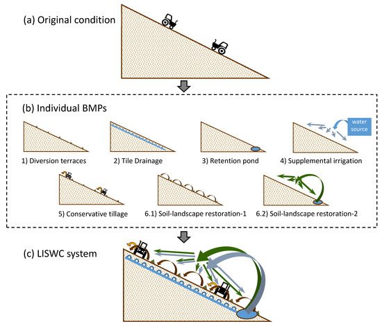
Figure 1. Illustration of the LISWC system on a sloping field.
Based on our current knowledge about the landscape processes and how each BMP functions, the effects of such an LISWC system (Figure 1c) can be summarized as follows. The DTGW effectively reduces water erosion. It also forces tillage to be conducted in the contour direction which reduces both water and tillage erosion. The drawback of DTGW and contour tillage on causing excessive water condition and poor soil drainage is effectively compensated by tile drainage. The other drawback of DTGW on increasing tillage erosion is effectively compensated by upslope-throw tillage and soil–landscape restoration within a terrace. The drawback of tile drainage on enhancing nutrient losses is in turn effectively reduced by the retention pond. On the other hand, in this LISWC system, the benefit of the retention pond is no longer just improving water quality downstream. The water retained in the retention pond facilitates supplemental irrigation, which otherwise will have to find other water resources. Meanwhile, excavating accumulated sediment is no longer just to restore the capacity of the retention pond. Sediment and its attached nutrients, which otherwise will leave the field and cause contaminations in waterways, are used as soil modification materials to restore the degraded soil landscape to its original condition. Overall, by integrating multiple BMPs into such an LISWC system, the shortcomings of each individual BMPs are minimized or compensated so that the benefits for the landscape as a whole are maximized.
The LISWC system is a system designed to conserve and reuse soil and water within the landscape by integrating multiple BMPs based on an understanding of the landscape processes and knowledge about the advantages and disadvantages of those BMPs. On a rolling landform field with a linear slope, an LISWC system can be established by integrating BMPs such as diversion terraces and grassed waterway systems, tile drainage, water retention structures, supplemental irrigation, conservative tillage practices and soil–landscape restoration. Water and tillage erosion will be reduced by diversion terraces and grassed waterways and conservative tillage; field drainage conditions will be enhanced by tile drainage; runoff water will be stored in the retention structure and reused for irrigation; most eroded soil will be returned to the soil loss area via soil–landscape restoration. This holistic perspective can be used to develop LISWC systems for other landform types as well as at larger scales such as for a watershed or a region. Future studies are needed for individual BMPs, the connections and interactions between individual BMPs, and analysis on the overall economic benefit of an LISWC system.